The European Space Agency has published a short guide on the recovery of Galileo satellites 5 and 6. The PDF of “Salvage in Space: Recovering Galileo 5 and 6” can be downloaded.
The four-page guide, written for a non-technical audience, describes the root cause of the anomaly that placed the two satellites into the wrong orbit, and the solution used to correct the orbits.
April marks the 20th anniversary of GPS FOC. U.S. Air Force Space Command declared Full Operational Capability (FOC) for the GPS constellation April 27, 1995, signifying the system met all requirements with 24 operational Block II/IIA satellites in their assigned orbital slots and providing both the military Precise Positioning Service (PPS) performance standard and the civil Standard Positioning Service (SPS) performance standard.
FOC was formally announced on July 17, 1995.
GPS IIF-9 Launch on March 25
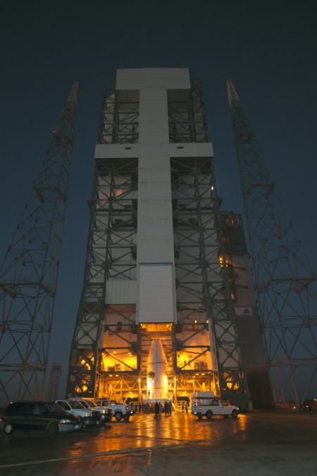
As this magazine went to press on March 19, the U.S. Air Force’s ninth GPS Block IIF satellite (GPS IIF-9) was being readied for a March 25 launch [since successfully launched]. The satellite was encapsulated in the Delta IV rocket’s 4-meter-diameter nose cone at a processing facility, and moved to the launch pad at Space Launch Complex 37 for mating to its booster inside the mobile service tower.
Launch is scheduled for March 25 at 2:36 p.m. U.S. Eastern time from Space Launch Complex 37 at Cape Canaveral Air Force Station, Fla. GPS IIF-9 marks the 29th Delta IV launch and the 57th operational GPS satellite to launch on a ULA or heritage launch vehicle.
CNAV Performance Compares Favorably to Legacy Signals
A March 5 announcement concerning the new L2C and L5 GPS civil signals states: “CNAV Message Types 10, 11, 30 and 33 are currently transmitted on seven GPS IIR-M (L2C) and eight GPS IIF satellites (L2C and L5). A Modernized Navigation (MODNAV) Tool integrated with the GPS ground control software (Architecture Evolution Plan or AEP) is generating the CNAV data messages. Daily CNAV uploads began December 31, 2014, and the U.S. Air Force reports that signal performance of CNAV matches or slightly outperforms Legacy performance: average user range error (RMS URE) from 25 February – 3 March 2015 was 0.50 m for Legacy and 0.57 m for Modernized; best week for Modernized signals since the broadcast initiated April 2014 was 0.42 m for 6 – 13 January 2015.
“Users are reminded that these CNAV signals are ‘pre-operational’ and should be used with discretion until they become fully operational; the L5 message is currently set unhealthy,” concluded Rick Hamilton, CGSIC Executive Secretariat, USCG Navigation Center, in a status email to the Civil Global Positioning System Service Interface Committee (CGSIC).
Galileo Six, Seven, Eight: Lay Them Straight
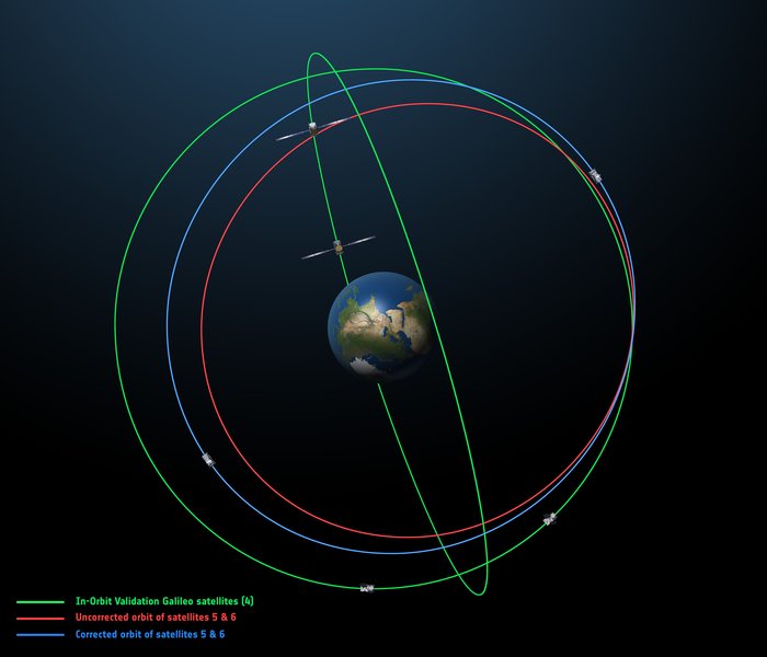
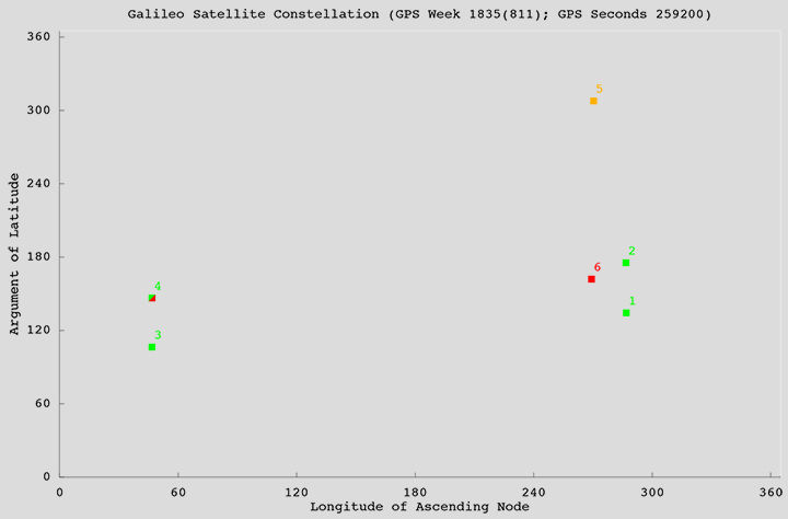
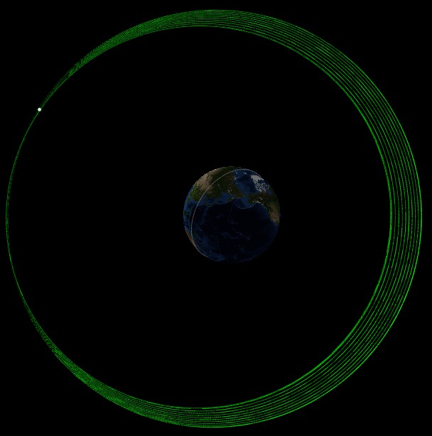
The original (in red) and corrected (in blue) orbits of the fifth and sixth Galileo satellites, along with that of the first four satellites (green).
On March 17, some stations participating in the International GNSS Service Multi-GNSS Experiment acquired E1 and E5a signals from Galileo 6 (FOC-FM2, GSAT0202). The satellite is using pseudorandom noise code E14.
This development follows the successful repositioning of the sixth Galileo satellite into a corrected orbit, which will now allow detailed testing to assess the performance of its navigation payload. A 20-meter-diameter antenna at the European Space Agency’s (ESA’s) Redu center in Belgium will study the strength and shape of the navigation signals at high resolution.
Launched with the fifth Galileo last August, its initial elongated orbit saw it traveling as high as 25,900 kilometers above Earth and down to a low point of 13,713 kilometers — confusing the Earth sensor used to point its navigation antennas at the ground.
A recovery plan was devised between ESA’s Galileo team, flight dynamics specialists at ESA’s ESOC operations centre and France’s CNES space agency, as well as satellite operator SpaceOpal and manufacturer OHB. This involved gradually raising the lowest point of the satellites’ orbits more than 3,500 km while also making them more circular.
The fifth Galileo entered its corrected orbit at the end of November 2014. Both its navigation and search-and-rescue payloads were switched on the following month to begin testing. Now the sixth satellite has reached the same orbit.
This latest salvage operation began in mid-January and concluded six weeks later, with 14 maneuvers performed in total. Its corrected position is effectively a mirror image of the fifth satellite’s, placing the pair on opposite sides of the planet. The exposure of the two to the harmful Van Allen Belt radiation has been greatly reduced, helping to ensure future reliability.
The corrected orbit means they will overfly the same location on the ground every 20 days. This compares with a standard Galileo repeat pattern of every 10 days, helping to synchronize their ground tracks with the rest of the constellation.
“I am very proud of what our teams at ESA and industry have achieved,” said Marco Falcone, head of the Galileo system office. “Our intention was to recover this mission from the very early days after the wrong orbit injection. This is what we are made for at ESA.”
The decision whether to use the two satellites for navigation and search-and-rescue purposes will be ultimately made by the European Commission, as the system owner, based on the in-orbit test results and the system’s ability to provide navigation data from the improved orbits.
March 27 Launch Date for Galileo Seven, Eight
The seventh and eighth Galileo satellites, set for launch together on March 27, were placed onto the Fregat upper stage of their Soyuz ST-B launcher in mid-March. [The satellites have been successfully launched.]
The Fregat stage will hold the satellites in place during their four-hour flight into orbit 22,300 kilometers above the Earth. Then, at the correct altitude, the two satellites are sprung away in opposing directions.
The Fregat upper stage was blamed for theAugust mis-delivery of Galileo satellites five and six. The root cause of the anomaly producing the wrong orbits was a shortcoming in the system thermal analysis performed during stage design, according to findings by an independent inquiry board.
The anomaly occurred during the flight of the launcher’s fourth stage, Fregat. It occurred about 35 minutes after liftoff, and was due to a temporary interruption of the joint hydrazine propellant supply to the Fregat thrusters. The interruption in the flow was caused by freezing of the hydrazine, resulting from the proximity of hydrazine and cold helium feed lines, these lines being connected by the same support structure, which acted as a thermal bridge. Ambiguities in the design documents allowed the installation of this type of thermal bridge between the two lines.
IRNSS Launch Scheduled for March 29
The launch of the fourth satellite for the Indian Regional Navigation Satellite System, previously scheduled for March 9, was postponed until March 29 at 13:00 UTC, due to the replacement of a faulty telemetry transmitter on the satellite. [The satellite has been successfully launched.]
IRNSS-1D will be fourth in the seven-spacecraft IRNSS constellation.
BeiDou, Too, in Late March
There are indications that the first satellite in the BeiDou Phase 3 expansion may be launched by the end of March [since successfully launched]. Apparently, a BeiDou satellite has been shipped to the Xichang launch site, and tracking ships have left port for the open ocean. Also, a philatelic first day cover for the launch (a common Chinese practice) has been issued with a March 2015 inscription. This is likely a launch of a medium Earth orbit (MEO)satellite.
Where It All Began for Galileo and EGNOS
The European Space Agency issued a press information notice on June 11, 1995 — in the same timeframe as the GPS FOC announcement noted on the previous page — titled “Europe’s Contribution to a Navigation Satellite System.”
“The European Commission, the European Space Agency (ESA), and the civil aviation organisation EUROCONTROL have agreed to cooperate on a joint programme).The European Satellite Navigation (ESN) Action Programme, elements of which are GNSS-1 [First Generation Global Navigation Satellite System] and GNSS-2, is planned to run for five years (from mid-1995 to mid-2000) with a budget of the order of 150 million euros.
“National aviation authorities and the parties involved in the action programme see Europe’s commitment to satellite navigation as being of strategic significance for the future.
“The main objective of the programme is to develop technologies that will ensure that data from the two existing Global Navigation Satellite Systems — the United States’ GPS and Russia’s GLONASS — which are both under military control, will also be available for civil use on a reliable basis and will provide the requisite precision.In parallel, studies will be conducted in order to make preparations for a second generation satellite-navigation and positioning system (GNSS-2), to be deployed as from 2005.
“In the first phase (GNSS-1), ESA’s contribution to the joint action programme will be EGNOS [European Geostationary Navigation Overlay Service].Satellites stationed in geostationary orbit at an altitude of about 36,000 km will relay to aircraft, shipping or road vehicles information that will enable the recipients to determine their actual positions with greater precision than is possible by using GPS/GLONASS data alone.Civil users of those systems receive artificially degraded data deviating by about 100 metres.EGNOS, will enable in particular, to increase the number of satellites that can be seen by a given user within the geostationary broadcast area.
“Around the period 2005–2008, after completing a trial period, the new system is due to be used as sole means.”
Galileo, Previously GNSS-2
“It is planned to develop GNSS-2 in the period between 2005 and 2020, building on experience acquired under GNSS-1.From the technical viewpoint, the second generation will be a considerable improvement on the first in terms of reliability, precision and availability.
“However, if Europe were to confine itself to developing the relevant technologies, its industry would have only a very slim chance of being involved in the construction of the satellites for the system or in the control and user segments for a second-generation civil system (GNSS-2). Given that U.S. and Russian firms are the current leaders in this area, it is necessary for strategic reasons for Europe to carry out a comprehensive development and demonstration programme as it must be able to prove it has the requisite capabilities before GNSS-2 becomes operational, which, in the experts’ opinion, will be from 2005.
“The time schedule foreseen for the different steps can be summarised as follows:
GNSS-1 mission analysis and definition studies: mid-1995 to mid-1996
European GNSS-1 pre-operational mission (task 1): to end 1997. Development of the geostationary network, following the Inmarsat III launch and first ranging demonstration phase
GNSS-1 (task 2): 1996 to end 1998. In parallel to the development of the network, the Ground Integrity Channel will be set up, followed by a second demonstration phase
GNSS-1 (task 3): 1997 to early 2000. Wide Area Differential service for precision approaches to be set up and tested
Introduction of GNSS-1 as sole means: 2000/2003.”
GPS World is indebted to Richard Langley’s CANSPACE archive of historical documents for this note of interest.
In August 2014, they were considered lost: Two Galileo satellites ended in the wrong orbit after their launch by a Soyuz from Kourou, French Guiana. Now the two satellites have been recovered and should be able to fulfill, at least partially, their mission, according to the ESA (the European Space Agency) — a situation made possible by the extended Galileo team, ESA and agency partners.
On March 17, some stations participating in the International GNSS Service Multi-GNSS Experiment acquired E1 and E5a signals from Galileo 6 (FOC-FM2, GSAT0202). The satellite is using pseudorandom noise code E14.
The orbit of Galileo 6 was recently adjusted to make it more circular with a higher perigee after it was launched into an incorrect orbit last August.
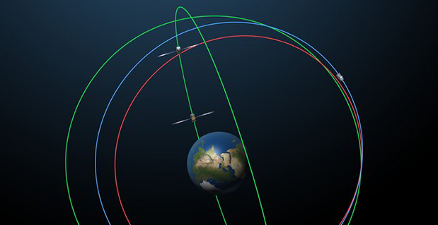
The original (in red) and corrected (in blue) orbits of the fifth and sixth Galileo satellites, along with that of the first four satellites (green). Photo: European Space Agency
By the European Space Agency
The sixth Galileo satellite of Europe’s navigation system has entered its corrected target orbit, which will allow detailed testing to assess the performance of its navigation payload.
Launched with the fifth Galileo last August, its initial elongated orbit saw it traveling as high as 25,900 km above Earth and down to a low point of 13,713 km — confusing the Earth sensor used to point its navigation antennas at the ground.
A recovery plan was devised between ESA’s Galileo team, flight dynamics specialists at ESA’s ESOC operations centre and France’s CNES space agency, as well as satellite operator SpaceOpal and manufacturer OHB. This involved gradually raising the lowest point of the satellites’ orbits more than 3500 km while also making them more circular.
The fifth Galileo entered its corrected orbit at the end of November 2014. Both its navigation and search and rescue payloads were switched on the following month to begin testing. Now the sixth satellite has reached the same orbit, too.
This latest salvage operation began in mid-January and concluded six weeks later, with 14 maneuvers performed in total. Its corrected position is effectively a mirror image of the fifth satellite’s, placing the pair on opposite sides of the planet. The exposure of the two to the harmful Van Allen Belt radiation has been greatly reduced, helping to ensure future reliability.
Significantly, the corrected orbit means they will overfly the same location on the ground every 20 days. This compares with a standard Galileo repeat pattern of every 10 days, helping to synchronize their ground tracks with the rest of the constellation.
The test results from Galileo 5 proved positive, with the same test campaign for the sixth satellite due to begin shortly, overseen by ESA’s Redu centre in Belgium. A 20 m-diameter antenna will study the strength and shape of the navigation signals at high resolution.
“I am very proud of what our teams at ESA and industry have achieved,” says Marco Falcone, head of Galileo system office. “Our intention was to recover this mission from the very early days after the wrong orbit injection. This is what we are made for at ESA.”
The decision whether to use the two satellites for navigation and search-and-rescue purposes will be ultimately taken by the European Commission, as the system owner, based on the in-orbit test results and the system’s ability to provide navigation data from the improved orbits.
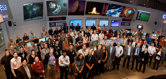
The Galileo operations team, joined by Director General Jean-Jacques Dordain, Director of Human Spaceflight and Operations Thomas Reiter and experts from European industry, in the Main Control Room at ESA’s Space Operations Centre, ESOC, in Darmstadt, Germany, August 28, 2014. (Photo courtesy of ESA)
Editor’s Note: See the report from the European Space Agency here.
An official with the European Space Agency has confirmed that the sequence of maneuvers to adjust the orbit of the second of two Galileo satellites launched into a wrong orbit in August 2014 has been completed.
The orbit of the first satellite, known variously as GSAT0201, Galileo FOC-FM1 or Galileo 5 (with COSPAR ID 2014-050A and NORAD ID 40128) was raised during operations carried out in November, and the satellite began transmitting L-band signals on Nov. 29.
Maneuvering of the second satellite (GSAT0202, Galileo FOC-FM2 or Galileo 6, with COSPAR ID 2014-050B and NORAD ID 40129) began around Jan. 15. The procedure took somewhat longer than that for the first satellite as it also involved changing the mean anomaly of the satellite to be about 180° away from that of the first satellite.
The locations of the satellites in the Galileo constellation are shown in the accompanying figure. Satellites in green are transmitting a full complement of L-band signals. Galileo 4 (GSAT0104), one of the in-orbit validation satellites, suffered a power anomaly and only transmits on the E1 frequency. Galileo 5 is transmitting L-band signals but its orbit cannot be properly represented in the Galileo broadcast almanac. Galileo 6 has not started transmitting valid L-band signals yet.
Officially, all Galileo signals are currently declared unavailable during an extended period of testing following ground segment upgrades. However, signals continue to be monitored by stations participating in the International GNSS Service Multi-GNSS Experiment.
At a press conference on Jan. 16, Director General Jean-Jacques Dordain of the European Space Agency (ESA) announced that the second errant full-operational capability (FOC) satellite, launched in August, had started its orbital change maneuver the previous day. He anticipated that the orbital change would be completed and the final orbit — “albeit somewhat lower in height than the one into which it was supposed to go” — achieved in “a few weeks.” He confirmed that both in-orbit FOCs are working well, fully operational, and providing excellent “on specification” positioning data.
The first errant Galileo satellite is now pointing toward Earth.
Two more FOC satellites are ready for launch, and a third has undergone thermal vacuum testing at ESA’s European Space Research and Technology Centre (ESTEC) facility in the Netherlands. Dordain said four would be available to launch soon, and he anticipated up to six FOCs being ready for launch during 2015.
The previous plan had called for four for 2015, but the year’s anticipated total now includes the two that were held back from launch during a December 2014 window, so the total number is the same. The actual launch schedule and launch vehicles are still under discussion, according to Dordain, and he said the European Commission (EC) would make a decision at the end of January on this issue. He refused to be drawn out on what ESA would recommend to EC on this front.
Jean-Jacques Dordain
“As you know, Soyuz did not place the first two FOC satellites in the right orbit. They only achieved very low orbits. This led and is still leading to delays in the deployment of the Galileo constellation. However, it’s not all bad news, because the two FOC satellites are working perfectly,” Dordain said.
“One of the two has already had its orbit changed, last November, and once in its new orbit, we ran all the new payload tests, and all the data that we have show that the FOC payload is the best in orbit today of the Galileo satellites. We were able to achieve on-spec positioning with the first FOC and the IOV satellites. It provides us with highly accurate positioning data,” Dordain said.
“Once we have both FOCs in their final orbits, not their nominal orbits, it’s true, but they are orbits that mean they will be usable for a long time, because they no longer go through the Van Allen belts.”
A video of the news conference is available here. The Galileo portion of the 2-hour video begins at 11:45. The event took place at ESA-HQ, Paris, France.
Will Be Employable for Surveying, Precise Positioning, and Geodesy
By Peter Steigenberger and André Hauschild, German Aerospace Center (DLR) / German Space Operations Center
The first Full Operational Capability (FOC) Galileo satellite started transmitting L-band navigation signals on November 29, 2014. Based on data collected by a global network of GNSS tracking stations of the Cooperative Network for GNSS Observation (CONGO) and the Multi-GNSS Experiment (MGEX) of the International GNSS Service (IGS), we determined that an E1 signal with pseudorandom noise code (PRN) E18 was first tracked at the station LLAG (La Laguna, Tenerife, Canary Islands) at 06:08 UTC. A few moments later, the satellite’s transmissions were also tracked at other MGEX stations including the E5a, E5b, and E5 AltBOC signals. Based on the computed satellite visibility at various tracking stations, the satellite could be positively identified as GSAT0201, also known as Galileo FOC-FM1 or Galileo 5 with COSPAR ID 2014-050A and NORAD ID 40128.
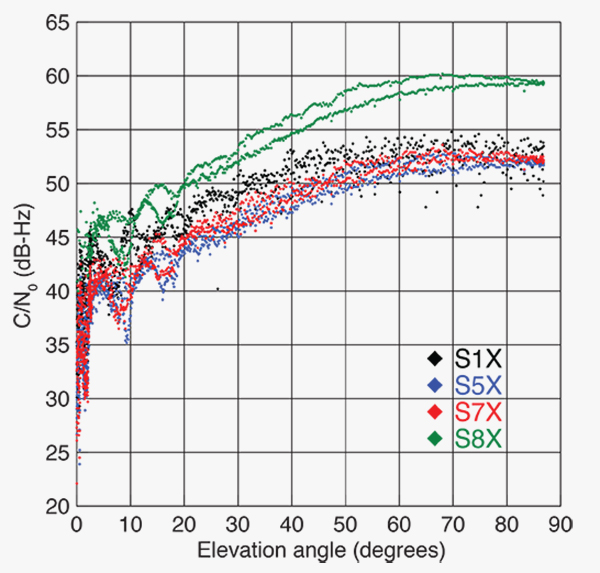
FIGURE 1 shows the carrier-to-noise-density ratio (C/N0) of the E18 signals tracked at the CONGO/MGEX station SIN1 (Singapore, using a Trimble NetR9 receiver with a Leica AR25.3 antenna). We selected the signals from this station for analysis due to an E18 pass occurring close to the zenith and covering almost the full range of elevation angles. The E5a and E5b signals (S5X and S7X RINEX identifiers) show very similar performance, whereas the C/N0 values of the E1 signal are 1–2 dB-Hz higher. The C/N0 values of the E5 AltBOC signal (S8X) reach 60 dB-Hz at high elevation angles, which is about 6 dB-Hz higher than the other signals.
Figure 1. Galileo E18 carrier-to-noise-density ratio for the CONGO/MGEX station SIN1 (Singapore).
The first pair of Galileo FOC spacecraft was launched on August 22 with a Soyuz launcher from the Guiana Space Centre, Kourou, French Guyana. Due to a malfunction of the Fregat upper stage, the satellites were injected into elliptical orbits with an inclination of about 49° instead of near circular orbits with 55° inclination. In November, the perigee of the first FOC satellite was raised by about 3,500 kilometers by a series of 11 maneuvers with a corresponding reduction in orbit eccentricity from 0.23 to 0.16.
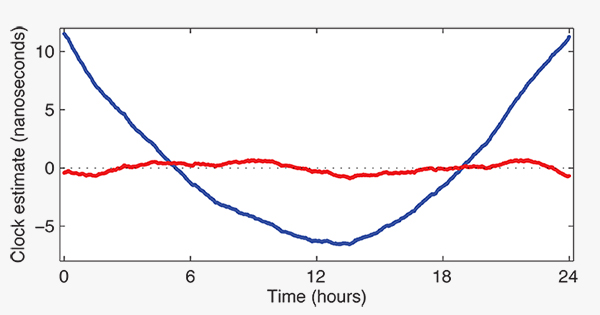
E18 has been included in the precise orbit and clock solutions of the MGEX analysis center at Technische Universität München (TUM) in Munich, Germany, since December 5. FIGURE 2 shows the detrended estimates of the active Galileo E18 clock for December 7. The presence of a pronounced quadratic term as well the large drift of 33.9 microseconds per day indicate that the active clock is a rubidium atomic frequency standard rather than a more precise passive hydrogen maser. The FOC satellites carry two of each kind of clock.
Figure 2. Galileo E18 clock estimates for December 7, 2014, with respect to the hydrogen maser at the Ottawa IGS station (NRC1) after removing an offset and drift (blue) or a second order polynomial (red).
The TUM orbit and clock product allows researchers to again compute dual-frequency positioning solutions using only Galileo observations, as the In-Orbit Validation satellite E20 has not transmitted an E5 signal since May, when a power anomaly left the satellite with the capability to only transmit an E1 signal. Furthermore, E20 currently does not transmit a navigation message.
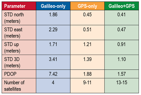
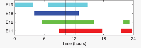
TABLE 1 shows the scatter of single-point positioning using pseudorange (code) observations from the MGEX station MAS1 (Maspalomas, Gran Canaria, Canary Islands) for a Galileo-only, a GPS-only, and a combined Galileo+GPS solution for December 6. At an elevation cut-off angle of 10°, four Galileo satellites were visible from 10:15 until 12:25 UTC (see FIGURE 3). The GPS-only solution covers the same time interval. The start time is not limited by the cut-off angle but an E18 transmission outage from 3:45–10:15 UTC.
TABLE 1. Single point positioning results for the MGEX station MAS1 (Maspalomas) for December 6, 2014.Figure 3. Galileo visibility at the MGEX station MAS1 (Maspalomas) on December 6, 2014. The time period considered in the single-point positioning is indicated by vertical lines.
We used an ionosphere-free linear combination of Galileo E1 and E5 AltBOC code observations and GPS L1 and L2 code observations with a 30-second sampling interval. As the Galileo-only solution suffered from position dilution of precision (PDOP) values of up to 830, a total of 32 epochs with PDOP values greater than 25 were excluded. The geometry of the remaining epochs is still pretty unfavorable. At a mean PDOP value of 7.4, the standalone position solution exhibits a 3D standard deviation (STD) error of 3.4 meters. Use of the Galileo satellites in a combined GPS+ Galileo solution improves the positioning performance. In particular, the height component benefits from the inclusion of the four Galileo satellites with a standard deviation improvement of 25 percent.
Despite the orbit injection error, the new Galileo FOC satellite has now been successfully activated and added to the Galileo constellation. Unfortunately, the current orbit is incompatible with the standard Galileo almanac format, which may cause restrictions for some commercial receiver types.
Nevertheless, the satellite can already be tracked by a wide range of geodetic receivers with existing firmware versions and it will, in fact, be possible to use the new satellite for diverse applications in surveying, precise positioning, and geodesy, as well as in general multi-GNSS studies. We now look forward to the activation of the second FOC satellite, which can be expected in early 2015 and will, for the first time, offer multi-frequency signals from a total of five Galileo satellites.
Sanctions Delay GLONASS-K2
According to Nikolai Testoyedov, the CEO of Information Satellite Systems Reshetnev, manufacturer of the GLONASS satellites, the company will now produce nine GLONASS-K1 satellites.
“For a smooth transition to a multi-functional group and due to issues with the very complex GLONASS-K2 satellites, we decided to continue with the GLONASS-K1 intermediate range of satellites, and we are preparing for the launch of nine units of this series,” he said.
He recalled the original plan was to launch two K1 satellites and then move to GLONASS-K2 satellites.
“In the beginning, really, we wanted after the two GLONASS-K1 satellites No. 11 and 12, to go for the launch of more advanced GLONASS-K2 devices. But, unfortunately, the plans had to be adjusted somewhat because of the sanctions restricting the delivery of radiation-resistant electronic components from the West. We have to put a hold on the in-depth development of technical and technological documentation and that delays us in terms of moving ahead by at least a year or two,”he said.
Reported by the Russian magazine Vestnik GLONASS, and relayed by Richard Langley’s CANSPACE listserv.
GNSS Mandates Would Violate Trade Agreements
A U.S. government representative stated at an international satnav forum that mandating use of specific GNSS services for applications such as air-traffic control, freight shipments, emergency calling, and road tolling could violate the terms of World Trade Organization (WTO) agreements that many nations, including all six GNSS providers, have signed.
Regional mandates already exist for GLONASS in Russia and BeiDou in China, and have been suggested and extensively discussed in Europe, as a way of stimulating the market adoption of Galileo receiver chipsets, thus recouping some of the massive public investment in the satnav system.
The presentation occurred during the Ninth Meeting of the International Committee on Global Navigation Satellite Systems (ICG), held Nov. 10–14, 2014, in Prague, Czech Republic.
Jason Kim, a senior policy analyst at the U.S. Department of Commerce, stated that the United States and the European Union already enjoy a productive dialog on GNSS trade issues under the 2004 U.S.-EU Agreement on GPS-Galileo Cooperation. In that agreement, both parties agreed to consult before establishing GNSS standards, certification requirements, regulations, mandates; affirmed their non-discriminatory approach with respect to GNSS trade; and established a working group to consider non-discrimination and other trade related issues.
Finally, the United States and the European Union recognized and reiterated in 2004 their commitments to WTO rules including those governing technical barriers to trade, specifically, that there would be no goods discrimination based on non-tariff measures such as regulations, standards, testing, or certification.
Kim made the remarks in the course of his presentation titled “GNSS Market Access.” He told GPS World that his presentation was directed less at the European Union, which has been conscientious of its WTO commitments, and more towards the rest of the ICG members, including non-provider nations that may be asked by GNSS providers to mandate specific systems.
“To promote adoption of their systems,” Kim stated, “GNSS providers are considering/implementing equipage mandates for various applications: aviation, motor-carrier and HAZMAT vehicle tracking, car accident reporting (eCall/ERA-GLONASS), and emergency phone calls (E112).
“The United States recommends technology-neutral, performance-based standards,” Kim continued, giving as example the U.S. E911 rules that specify a required positioning accuracy and then allow wireless carriers to choose the best technical solutions according to their lights.
The U.S. government presentation at ICG revealed particular concern that regulations under consideration could adversely affect the sales of U.S. GPS-enabled hardware in many industry sectors. All members of the WTO, including the six GNSS providers on the ICG, are bound to a range of trade agreements designed to promote open-market access, all cited in the Prague ICG presentation: the General Agreement on Tariffs and Trade (GATT), the Agreement on Technical Barriers to Trade (TBT), and the General Agreement on Trade in Services (GATS). The United States, Europe, Japan, and 12 others are also parties to the WTO Agreement on Government Procurement (GPA).
European Commission officials have publicly and recently stated that they are considering how to stimulate Galileo use, in particular through regulatory measures requiring that navigation equipment be installed on aircraft, automobiles, and other platforms.
“Requiring specific systems arbitrarily prevents or penalizes imports of goods having perfectly functional GNSS capability,” said Kim. “WTO members must comply with TBT obligations in setting technical regulations.”
He concluded his presentation by requesting that the ICG Providers’ Forum add GNSS market access to its future agenda for discussion, and consider developing a new principle on market access for future adoption.
They said it wasn’t possible — well to be frank, I said it wasn’t possible – but one of the two “misplaced” Galileo satellites, plucky Doresa, has delivered an early Christmas present to the European GNSS community by providing a first fix on Tuesday, December 9. The signal was received at the European Space Agency’s (ESA’s) technical centre in Noordwijk, the Netherlands and at the Galileo In-Orbit-Validation (IOV) test station at Redu in Belgium. Doresa teamed with the remaining three functioning Galileo IOV satellites to provide a Galileo positioning data first fix with horizontal accuracy better than two metres.
Since then fixes have also been performed using Galileo’s Public Regulated Service (PRS), the civilian encrypted highest-precision signal and one of the constellation’s unique selling points.
The satellite had transmitted its first navigation signal in space on November 29, following its attainment of a safer, more stable, and more circular orbit with the perigee some 3,500 kilometres higher than its original placement.
Doresa’s salvage has been a slow and steady journey since it was placed, with sister satellite Melina, into a fairly useless orbit in August following a launch anomaly. The original orbit, with a 26,000-kilometer apogee and a 13,800-kilometer perigee, prevented their use for navigation services because they were too low during part of their orbit to sense the horizon and correctly determine their own position. They were also getting a daily dose of radiation from the Van Allen belts.
Elevation
The elevation of the satellite started in late October and involved 11 firings of Doresa’s on-board thrusters. The craft now has only 15 kilos left from its original 65 kilo fuel payload but, given the fact that normally Galileo satellites are not required to make regular orbital manoeuvres, ESA engineers estimate this should be enough for a good 12 years of operation in the new orbit.
The next stage will be to repeat this manoeuvre with the second Full Operational Capability (FOC) satellite, Melina, according to a plan to get that into a similar orbit by the New Year. Pending tests of their positioning, navigation, and timing payloads, the two spacecraft are then likely to be able to contribute to the future Galileo navigation constellation. This was confirmed by Didier Faivre, ESA’s director for navigation, during the agency’s ministerial council meeting on December 2 in Luxembourg.
This end result is the best possible scenario given where the satellites were left after launch and is a considerable triumph for ESA’s mission control teams and flight engineers. Doresa is now able to use its Earth sensor continuously and keep its antennae orientated towards the Earth. Despite more than a month’s exposure to the Van Allen radiation, testing so far has shown no ill effects.
“The very good geometry of the satellites in the sky relative to the receivers helped us to achieve this result, plus the signal strength of the fifth satellite,” explained Gustavo Lopez Risueno, coordinating the receiver team at the Navigation Laboratory in ESA’s ESTEC technical centre.
The satellite signals should be usable immediately, in combination with additional navigation message information provided through ground networks, with mass market receivers. In fact the ESTEC Navigation Laboratory, working in conjunction with the European Commission and the European GNSS Agency (GSA), have already performed position fixes with both Galileo and GPS satellites using only navigation-assistance information.
With some adjustments to the Galileo network’s ground infrastructure, it looks like Doresa and Melina will be able to carry out most of the roles they were originally designed to do. They are the first of 22 Galileo FOC satellites to be built by OHB and launched by ESA over the next few years.
Toasted antennae
More good news. The problem with Galileo’s fourth IOV satellite, named Sif, that took it out of action at the end of May seems to have been characterised and — again — indicates that the satellite is not a complete loss to the constellation. While Sif’s E5 and E6 frequency bands are definitively blown, the satellite’s E1 Open Service band should be capable of broadcast.
The problem appears to have been a defective antennae. The four IOV satellites utilise one antennae design, while the FOC satellites have a different design. Fortunately there is no sign of a similar issue with the three other IOV craft, but they have been operating on reduced power as a precaution while the root cause of Sif’s failure is determined. ESA is currently fail-testing an example of the culprit antennae in the laboratory to see if the failure mode can be characterised.
“One of the possible root causes links the problem with the power emitted by the antenna. When we know more we’ll decide what to do with the other three. Since this event occurred in May and June, no more issues have arisen,” Faivre said.
Agreement
This is all a remarkable turnaround and good news for the wider European GNSS community and those stakeholders who have invested in the Galileo programme and its burgeoning application industry. Let’s hope the good fortune continues through 2015.
The administrative side of things is certainly moving on with the signing in October of an agreement which delegates a range of exploitation tasks for Galileo from the European Commission to the GSA, providing a framework and budget for the development of services and operations through to 2021.The signing of the agreement is an initial step towards the full Galileo Exploitation Phase. Current planning calls for this exploitation phase to be progressively rolled out from 2015, with full operability scheduled for 2020.
“With Galileo, we aim to provide a tangible service to European citizens, and this Delegation Agreement ensures we have the tools and funding necessary to achieve this,” said GSA Executive Director Carlo des Dorides. The agreement was signed by Daniel Calleja Crespo of the European Commission and des Dorides. The document specifically sets the actions to be implemented, the amount of funding provided, and the conditions for the overall management.
Innovation
In the same month, the First Satellite Masters Conference took place in Berlin on October 23 and 24. The conference encompassed the 2014 edition of the European Satellite Navigation Competition (ESNC). The event was a great showcase for the innovation, skill, and passion of the entrepreneurs, usually young, who are building the satellite application market in Europe.
For example, the winner of the GSA special prize at ESNC 2014 is developing Galileo modules for the Google Ara modular smartphone concept, a potential game-changer for positioning in the mobile-phone market. Ara uses interchangeable modules to deliver a smartphone that can be whatever a user wants it to be, complete with first- and third-party components including sensors, cameras, radio antennas, and more. Consumers will be able to order them as of January 2015.
Google developers believe an Ara smartphone will last multiple years, much longer than current hardware, since it won’t be obsolete nearly as quickly. Further, Ara could open the smartphone market to billions of new users across the globe.
I spoke with Giovanni Vecchione of Deimos Space, who received the € 40 000 GSA/ESNC prize during the awards ceremony at Deutsche Telekom’s magnificent headquarters in the German capital.
“With a traditional chip structure, all of a smartphone’s functions are currently combined into a single component, which makes it difficult to add or change a function,” explained Giovanni. “With a modular structure, you have the option to simply switch out a component, meaning a smartphone’s capabilities can be easily enhanced.”
Vecchione’s innovation is to use another of Galileo’s unique selling points: the E5 broadband signal. While mass market smartphones will use the E1 signal, the availability of high-end phones offering enhanced accuracy through the use of the E5 signal will appeal to many users. A second module will implement an external antenna interface. Together these developments could deliver an ARA phone offering high precision (centimetre-level accuracy) positioning and multipath-resistant solutions.
Wishing you all a very peaceful and prosperous New Year and hoping Santa has your coordinates accurately entered in his sleigh satnav!
Will Be Employable for Surveying, Precise Positioning, and Geodesy
By Peter Steigenberger and André Hauschild, German Aerospace Center (DLR) / German Space Operations Center
The first Full Operational Capability (FOC) Galileo satellite started transmitting L-band navigation signals on November 29, 2014. Based on data collected by a global network of GNSS tracking stations of the Cooperative Network for GNSS Observation (CONGO) and the Multi-GNSS Experiment (MGEX) of the International GNSS Service (IGS), we determined that an E1 signal with pseudorandom noise code (PRN) E18 was first tracked at the station LLAG (La Laguna, Tenerife, Canary Islands) at 06:08 UTC. A few moments later, the satellite’s transmissions were also tracked at other MGEX stations including the E5a, E5b, and E5 AltBOC signals. Based on the computed satellite visibility at various tracking stations, the satellite could be positively identified as GSAT0201, also known as Galileo FOC-FM1 or Galileo 5 with COSPAR ID 2014-050A and NORAD ID 40128.
FIGURE 1 shows the carrier-to-noise-density ratio (C/N0) of the E18 signals tracked at the CONGO/MGEX station SIN1 (Singapore, using a Trimble NetR9 receiver with a Leica AR25.3 antenna). We selected the signals from this station for analysis due to an E18 pass occurring close to the zenith and covering almost the full range of elevation angles. The E5a and E5b signals (S5X and S7X RINEX identifiers) show very similar performance, whereas the C/N0 values of the E1 signal are 1–2 dB-Hz higher. The C/N0 values of the E5 AltBOC signal (S8X) reach 60 dB-Hz at high elevation angles, which is about 6 dB-Hz higher than the other signals.
Figure 1. Galileo E18 carrier-to-noise-density ratio for the CONGO/MGEX station SIN1 (Singapore).
The first pair of Galileo FOC spacecraft was launched on August 22 with a Soyuz launcher from the Guiana Space Centre, Kourou, French Guyana. Due to a malfunction of the Fregat upper stage, the satellites were injected into elliptical orbits with an inclination of about 49° instead of near circular orbits with 55° inclination. In November, the perigee of the first FOC satellite was raised by about 3,500 kilometers by a series of 11 maneuvers with a corresponding reduction in orbit eccentricity from 0.23 to 0.16.
E18 has been included in the precise orbit and clock solutions of the MGEX analysis center at Technische Universität München (TUM) in Munich, Germany, since December 5. FIGURE 2 shows the detrended estimates of the active Galileo E18 clock for December 7. The presence of a pronounced quadratic term as well the large drift of 33.9 microseconds per day indicate that the active clock is a rubidium atomic frequency standard rather than a more precise passive hydrogen maser. The FOC satellites carry two of each kind of clock.
Figure 2. Galileo E18 clock estimates for December 7, 2014, with respect to the hydrogen maser at the Ottawa IGS station (NRC1) after removing an offset and drift (blue) or a second order polynomial (red).
The TUM orbit and clock product allows researchers to again compute dual-frequency positioning solutions using only Galileo observations, as the In-Orbit Validation satellite E20 has not transmitted an E5 signal since May, when a power anomaly left the satellite with the capability to only transmit an E1 signal. Furthermore, E20 currently does not transmit a navigation message.
TABLE 1 shows the scatter of single-point positioning using pseudorange (code) observations from the MGEX station MAS1 (Maspalomas, Gran Canaria, Canary Islands) for a Galileo-only, a GPS-only, and a combined Galileo+GPS solution for December 6. At an elevation cut-off angle of 10°, four Galileo satellites were visible from 10:15 until 12:25 UTC (see FIGURE 3). The GPS-only solution covers the same time interval. The start time is not limited by the cut-off angle but an E18 transmission outage from 3:45–10:15 UTC.
TABLE 1. Single point positioning results for the MGEX station MAS1 (Maspalomas) for December 6, 2014.Figure 3. Galileo visibility at the MGEX station MAS1 (Maspalomas) on December 6, 2014. The time period considered in the single-point positioning is indicated by vertical lines.
We used an ionosphere-free linear combination of Galileo E1 and E5 AltBOC code observations and GPS L1 and L2 code observations with a 30-second sampling interval. As the Galileo-only solution suffered from position dilution of precision (PDOP) values of up to 830, a total of 32 epochs with PDOP values greater than 25 were excluded. The geometry of the remaining epochs is still pretty unfavorable. At a mean PDOP value of 7.4, the standalone position solution exhibits a 3D standard deviation (STD) error of 3.4 meters. Use of the Galileo satellites in a combined GPS+ Galileo solution improves the positioning performance. In particular, the height component benefits from the inclusion of the four Galileo satellites with a standard deviation improvement of 25 percent.
Despite the orbit injection error, the new Galileo FOC satellite has now been successfully activated and added to the Galileo constellation. Unfortunately, the current orbit is incompatible with the standard Galileo almanac format, which may cause restrictions for some commercial receiver types.
Nevertheless, the satellite can already be tracked by a wide range of geodetic receivers with existing firmware versions and it will, in fact, be possible to use the new satellite for diverse applications in surveying, precise positioning, and geodesy, as well as in general multi-GNSS studies. We now look forward to the activation of the second FOC satellite, which can be expected in early 2015 and will, for the first time, offer multi-frequency signals from a total of five Galileo satellites.
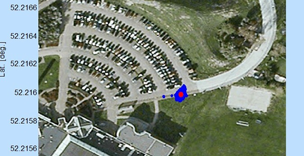
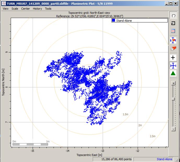
Scatter plot of the Galileo fix performed in ESA’s Navigation Laboratory at its ESTEC technical centre on 9 December 2014. The plot was calculated by the Lab’s Septentrio Test User Receiver, with dispersion of less than 2 m.
News from the European Space Agency
Galileo’s fifth satellite — recently salvaged from the wrong orbit to begin navigation testing — has been combined with three predecessors to provide its first position fix.
Test receivers at ESA’s technical centre in Noordwijk, the Netherlands, and at the Galileo In-Orbit Test station at Redu in Belgium received the signals at 12:48 GMT on December 9 from the quartet of satellites and fixed their horizontal positions to better than 2 meters.
This achievement is particularly significant because the fifth satellite is the first of a new design of 22 Galileo satellites set to be launched over the next few years.
Further position fixes were then made by France’s CNES space agency in Toulouse, France, as noted by Bernard Bonhoure: “The results are as good as those for the first Galileo fixes in 2013 with the initial four satellites.”
The following day, fixes were performed using Galileo’s Public Regulated Service, the encrypted highest-precision class of signal.
“The very good geometry of the satellites in the sky relative to the receivers helped us to achieve this result, plus the signal strength of the fifth satellite,” explained Gustavo Lopez Risueno, coordinating the receiver team at the Navigation Laboratory in ESA’s ESTEC technical centre.
“This is a significant milestone for the Galileo program because it marks the very first time that a Full Operational Capability satellite has performed a fix together with its In-Orbit Validation predecessors — which were the first four satellites launched into orbit, in 2011 and 2012. This establishes they work together well.
“While it is not yet possible to make routine use of the fifth Galileo, this shows such an outcome is within our reach.
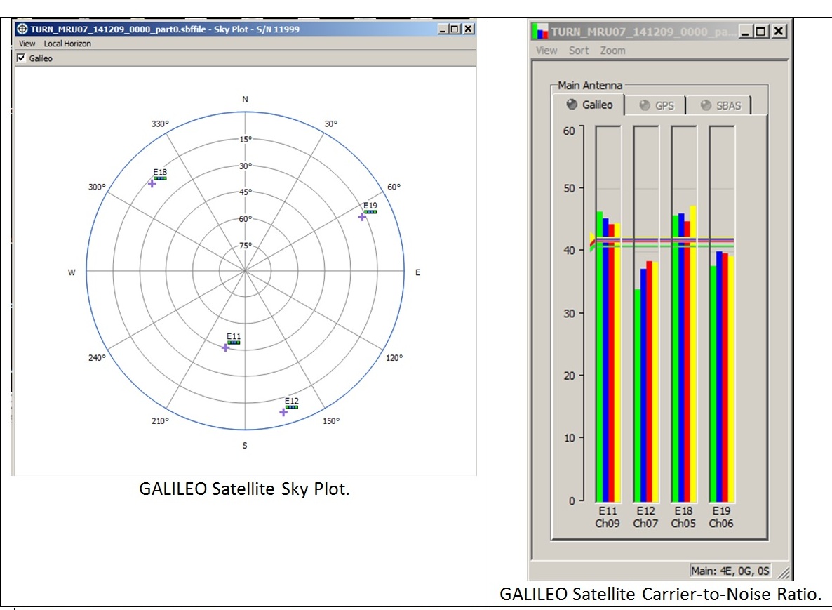
Galileo satellite geometry and received signal strength for the December 9 fix using the first Galileo FOC satellite. The first Galileo FOC satellite corresponds to E19 on the left display; IOV PFM to E11, FM2 to E12 and FM3 to E19.
“In particular, it opens the door to its immediate use in combination with additional navigation message information provided through ground networks, which is a standard mode of operation for mass market receivers, such as those found in our smartphones.”
The fifth and sixth satellites were delivered into the wrong orbit by their Soyuz–Fregat rocket in August. Their elongated orbit took them out to 25,900 km above Earth and back down to 13,713 km, rather than the planned circular path at 23,222 km. The angle of the orbit to the equator was also wrong.
The satellites’ shifting altitude left them unable to lock onto Earth for part of each orbit, preventing them from being used for navigation purposes.
But, last month, a series of 11 maneuvers took the fifth satellite into a more circular orbit, some 3500 km higher, allowing its navigation payload to be switched on for testing. A similar salvage operation is planned soon for its companion.
The main hurdle in using the fifth (and subsequently sixth) satellite operationally is that mass market receivers in particular might take longer to find it. Their orbits fall outside the almanacs satellite-locating standard broadcast within navigation messages.
Utilizing navigation-assistance information would be a way of shortening acquisition times — and ESTEC’s Navigation Laboratory has already demonstrated it with mass market receivers.
Working in conjunction with the European Commission and Europe’s Global Navigation Satellite Systems Agency, the Lab performed position fixes with both Galileo and GPS satellites using only navigation-assistance information.
Test position fix in the grounds of ESTEC, performed with a mass-market receiver using navigation-assistance information, based on signals from the fifth Galileo satellite plus GPS satellites. This satellite’s elliptical orbit means extra data are needed to speedily utilize its signals, which could be provided through ground networks. Navigation-assistance information is already employed by the mass market receivers found within smartphones. Source: European Space Agency
EDITOR’S NOTE: Researchers at the German Aerospace Center (DLR) report on their success in producing a pseudorange-based all-Galileo position fix using precisely determined satellite orbits and clocks from Technische Universität München (TUM) in the January issue of GPS World. Richard Langley reports that his team at the University of New Brunswick has managed to produce a Galileo-only carrier-phase-based precise-point-positioning solution with better than decimeter accuracy using TUM’s orbits and clocks.
Also, GMV performed a first Galileo-only PPP with IOV + FOC-1 satellite with data from December 6, obtaining centimetric accuracy. Read about their results on their blog.
Europe’s fifth Galileo satellite, one of two delivered into a wrong orbit by VS09 Soyuz-Fregat launcher in August, transmitted its first navigation signal in space on Saturday, November 29. It has reached its new target orbit and its navigation payload has been successfully switched on.
A detailed test campaign is under way now the satellite has reached a more suitable orbit for navigation purposes.
Recovery
The fifth and sixth Galileo satellites, launched together on August 22, ended up in an elongated orbit traveling up to 25,900 km above Earth and back down to 13,713 km.
A total of 11 maneuvers were performed across 17 days, gradually nudging the fifth satellite upwards at the lowest point of its orbit. As a result, it has risen more than 3,500 km and its elliptical orbit has become more circular.
“The maneuvers were all normal, with excellent performance both in terms of thrust and direction,” explained Daniel Navarro-Reyes, ESA Galileo mission analyst. “The final orbit is as we targeted and is a tribute to the great professionalism of all the teams involved.”
The Launch and Early Operations Phase (LEOP) for Galileo satellites is overseen by a joint operations team from ESA and the French space agency CNES, alternately working from ESOC in Darmstadt, Germany, and the CNES LEOP Control Centre in Toulouse, France. Photo: ESA
The commands were issued from the Galileo Control Centre by spaceopal, the Galileo operator, at Oberpfaffenhofen in Germany, guided by calculations from a combined flight dynamics team of ESA’s Space Operations Centre, ESOC, in Darmstadt, Germany and France’s CNES space agency. The commands were uploaded to the satellite via an extended network of ground stations, made up of Galileo stations and additional sites coordinated by France’s CNES space agency. Satellite manufacturer OHB also provided expertise throughout the recovery, helping to adapt the flight procedures.
Until the maneuvers started, the combined ESA–CNES team maintained the satellites pointing at the Sun using their gyroscopes and solar sensors. This kept the satellites steady in space but their navigation payloads could not be used reliably.
In the new orbit, the satellite’s radiation exposure has also been greatly reduced, ensuring reliable performance for the long term.
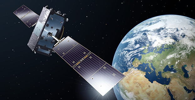
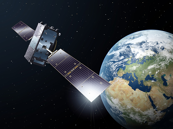
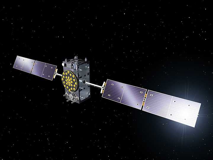
A Galileo Full Operational Capability (FOC) satellite, following on from the first four Galileo satellites already in orbit. A total of 22 FOC satellites are on the way, built by OHB in Germany with navigation payloads from Surrey Satellite Technology Ltd. in the UK. Photo: ESA
A suitable orbit
The revised, more circular orbit means the fifth satellite’s Earth sensor can be used continuously, keeping its main antenna oriented towards Earth and allowing its navigation payload to be switched on.
Significantly, the orbit means that it will now overfly the same location on the ground every 20 days. This compares to a normal Galileo repeat pattern of every 10 days, effectively synchronizing its ground track with the rest of the Galileo constellation.
The navigation test campaign
The satellite’s navigation payload was activated on November 29, to begin the full In-Orbit Test campaign. This is being performed from ESA’s Redu centre in Belgium, where a 20-meter-diameter antenna can study the strength and shape of the navigation signals at high resolution.
“First, the various payload elements, especially the Passive Hydrogen Maser atomic clock, were warmed up, then the payload’s first ‘signal in space’ was transmitted,” said David Sanchez-Cabezudo, managing the test campaign.
“The satellite-broadcast L-band navigation signal is monitored using the large antenna at Redu, with experts from OHB and Surrey Satellite Technology Ltd — the payload manufacturer, based in Guildford, UK — also on hand to analyze how it performs over time.”
The first Galileo FOC navigation signal-in-space transmitting in the three Galileo frequency bands (E5/E6/L1) was tracked by Galileo Test User Receivers deployed at various locations in Europe, namely at Redu (B), ESTEC (NL), Weilheim (D) and Rome (I). The quality of the signal is good and in line with expectations.
The Search And Rescue (SAR) payload will be switched on in few days in order to complement the in-orbit test campaign.