Tag: Ganesh Pattabiraman

  • NextNav tests 3D PNT service leveraging cellular infrastructure

    NextNav tests 3D PNT service leveraging cellular infrastructure


    NextNav logo

    NextNav has successfully tested its positioning and timing solution that combines the company’s assured position, navigation and timing (PNT) TerraPoiNT system with existing LTE and 5G network signals. The test, which took place in San Jose, California, demonstrated how TerraPoiNT signals can be integrated with existing cellular signals to deliver accurate 3D positioning and timing information that is not reliant on GPS and GNSS signals.

    Using dedicated terrestrial transmitters and LTE/5G signals, NextNav’s system delivers accurate and reliable 3D positioning and timing information and can augment or complement GPS in places where GPS signals may not be available. Integrating TerraPoiNT with LTE and 5G signals provides a rapid and cost-effective approach to scaling resilient PNT solutions in GPS-denied environments.

    “Whether its utilities, banks, data centers, transportation, or emergency services, critical infrastructure today is reliant on GPS for position, navigation and timing services, making it highly vulnerable to GPS as a single point of failure” said Ganesh Pattabiraman, co-founder and CEO of NextNav. “With this integration, we have demonstrated a highly scalable and lower cost alternative — a 3D PNT solution which overcomes the vulnerabilities of GPS with a complementary ground-based resilient PNT layer that extends PNT capabilities in urban and indoor environments.”

  • NextNav showcases APNT backup to GNSS at European JRC trial

    NextNav showcases APNT backup to GNSS at European JRC trial

    NextNav logoNextNav participated in the European Commission’s Joint Research Centre (JRC) alternative positioning, navigation and timing (APNT) evaluation in Ispra, Italy. At the trial, NextNav showcased an alternative PNT backup to GNSS, TerraPoiNT.

    According to the JRC, the trial is analyzing the technologies “which could deliver positioning, and/or timing information, independently from GNSS, to be effective backup in the event of GNSS disruption, and if possible to be able to provide PNT in the environments where GNSS cannot be delivered.”

    The test furthers the European Union’s creation of a backup to GNSS and is intended to assess which technologies could strengthen and expand the European PNT capacity.

    PNT services are critical for the global economy, with studies estimating a contribution to the European GDP of approximately 10%. Today, GNSS services are the backbone of PNT, with an increasing role in new services and technologies, including car-sharing, autonomous vehicles, ship and aircraft navigation, smart logistics and precision agriculture.

    It’s About Time

    The timing capabilities of PNT are heavily utilized today by critical infrastructure, which is strategic from a commercial and societal perspective, including telecom, energy, finance and transportation. Published studies estimated economic losses of around 1 billion EUR per day if GNSS were unavailable.

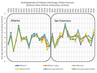
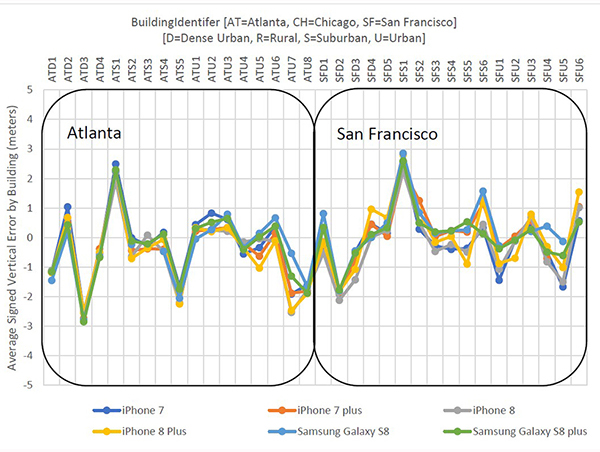
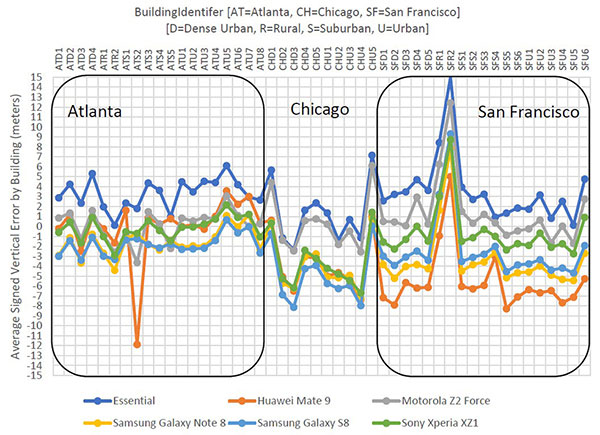
    NextNav’s TerraPoiNT trial focused on measuring the precision of timing delivery across alternate timing sources to better understand performance in GNSS-free environments — including instances of outages, spoofing and jamming. As a part of the trial, NextNav also demonstrated its capabilities in providing both indoor and outdoor z-axis vertical location.

    TerraPoiNT is a system for assured PNT that uses terrestrial transmitters deployed around a service area to triangulate the location of a device. Unlike national space-based systems, the proximity of NextNav’s transmitters makes the signal strength 100,000 times that of GPS.

    “The trials are part of the global trend to develop a resilience layer to space-based GPS/GNSS systems that is more secure and available,” said Ganesh Pattabiraman, NextNav CEO. “We are redefining the capabilities of APNT technologies and look forward to working with the European Commission on furthering these initiatives to build a GNSS backup layer that can deliver highly precise PNT across use-cases.”

    Trials for U.S., Europe

    The U.S. and countries across Europe continue to invest in both understanding and taking steps towards creating a resilient PNT layer in each nation. Participation in the JRC trial builds upon the recent evaluation of APNT technologies in the United States, including a 2021 U.S. Department of Transportation report, where TerraPoiNT was found to be the best performing APNT solution across use cases.

    Further, NextNav recently created an APNT testbed in the San Francisco Bay area that was developed as part of a U.S. Department of Homeland Security demonstration used to evaluate the precision and resilience of NextNav’s TerraPoiNT network.

    The JRC is expected to report results from the evaluation this spring.

  • Floor-level positioning accuracy demonstrated for indoor mobile calls

    Floor-level positioning accuracy demonstrated for indoor mobile calls

    <b>NextNav Results: </b>Vertical accuracy delivered by various phone models using signals from an installed network of NextNav beacons. (Plots: NextNav, from ex parte FCC filing, Aug. 8)
    NextNav Results: Vertical accuracy delivered by various phone models using signals from an installed network of NextNav beacons. (Plots: NextNav, from ex parte FCC filing, Aug. 8)

    According to NextNav, its altitude service delivered floor-level accuracy in 94 percent of test calls in recent blind industry tests commissioned by the Cellular Telephone Industry Association.

    The Stage Z Tests were designed to develop a proposed Z-axis (vertical) metric for indoor wireless 9-1-1 calls, as required by the Federal Communications Commission (FCC).

    NextNav’s Metropolitan Beacon System (MBS)-based services enable mobile phones and other devices to reliably determine their location and timing in indoor and urban environments where GPS signals cannot be received, the company said. NextNav’s 3D location services include accurate horizontal positioning, floor-level altitude precision, and context and visualization applications.

    <b>Polaris Results: </b>Vertical accuracy delivered by various phone models using signals from an installed network of NextNav beacons. (Plots: NextNav, from ex parte FCC filing, Aug. 8)
    Polaris Results: Vertical accuracy (Plots: Next Nav, from ex party FCC filing, Aug. 9)

    Delivered over a managed network on the licensed spectrum with carrier-grade dependability and metropolitan-wide coverage, NextNav’s services are designed for public safety applications, E911 and critical infrastructure as well as the multitude of consumer, internet of things and commercial applications that require reliable indoor 3D location or precision timing.

    According to NextNav, the Stage Z Tests evaluated the ability of various technologies to accurately locate mobile 911 callers in the vertical dimension in challenging indoor environments spread across an entire metropolitan area. The tests were conducted using popular off-the-shelf iOS and Android devices running a software client provided by NextNav. The tests included more than 70,000 emergency-style calls generating altitude fixes from more than 200 different test locations.

    “Our ability to deliver floor-level height accuracy has the potential to speed up emergency response time and save lives,” said Ganesh Pattabiraman, co-founder and CEO of NextNav. “The ability to precisely locate the exact floor is a significant breakthrough for wireless 9-1-1 location technologies.”

  • Expert Opinions: What will help regulators, public accept autonomous vehicles on the road?

    Q: What advance — or, overcoming what challenge — will most enable acceptance of autonomous vehicles on the road with regulators and the public?

    Ganesh Pattabiraman Co-founder, CEO Nextnav
    Ganesh
    Pattabiraman
    Co-founder, CEO
    Nextnav

    A: Similar to airplanes with an autopilot feature, the key issues that must be addressed in autonomous vehicles are redundancy and reliability of systems and appropriate, timely signals to the operator. One key area where this is required is the location of the vehicle. Autonomous location systems have to take into account areas where GPS works fine — but may suffer from an outage — and where GPS does not work, such as in urban canyons.


    Jane Macfarlane Chief Scientist, Head of Research HERE
    Jane
    Macfarlane
    Chief Scientist,
    Head of Research
    HERE

    A: Autonomous vehicles face two key challenges. The first is enabling the vehicle to see beyond its sensors. Autonomous vehicles are composed of two functions: sensing the local environment and controlling the vehicle to operate in the sensed environment. This model must be extended to include the larger environment using cloud-delivered map information informed by a connected vehicle fleet. The second is building intelligence that allows autonomous vehicles to share the road safely with human drivers.


    Kevin Dennehy Contributing Editor, GPS World; Director, Driverless Conference
    Kevin
    Dennehy
    Contributing Editor, GPS World; Director,
    Driverless Conference

    A: The development of autonomous vehicle sensors, artificial intelligence and software is advancing rapidly. Technology is being tested in open-road environments — and in bad weather. Component costs are falling as technology companies and automakers eye specific rollout dates. What could slow this developing industry is bad press, and the resulting government regulation, from a high-profile cyber security breach or an incident like a partially autonomous car getting into a fatal crash.