To bridge the gap between chipset and receiver manufacturers and GNSS simulator manufacturers, EUSPA, together with the European Commission and the Joint Research Centre (JRC), is organizing a GNSS Signal Simulator Manufacturers Forum on December 13.
The online forum will aim to help signal simulator manufacturers keep their products up to date by presenting the latest service interface control documents (ICDs), including those for the Galileo Open Service Navigation Message Authentication, the Galileo High Accuracy Service and for the I/NAV improvements. The forum will also serve as a channel for addressing GNSS signal simulator manufacturers’ needs, questions, and concerns.
Manufacturers use ICDs to access information provided from a GNSS satellite’s Signal in Space (SiS) or from such terrestrial means as the internet. However, before a manufacturer can turn this information into a new product or service, they must first test it – which is where GNSS simulators come into play.
Signal simulators play a critical role within the GNSS product pipeline. Chipset and receiver manufacturers have rapidly evolving needs. In order to keep up, GNSS signal simulators must be regularly updated. To do this, however, simulator manufacturers must know what those needs are.
“Whether it be a personal navigation system or smart watch, before a device or application that relies on GNSS signals hits the market manufacturers need to ensure it works,” says Fiammetta Diani, Head of Market, Downstream and Innovation at EUSPA. “GNSS simulators allow manufacturers to test the accuracy of their receivers by simulating such real-world factors as vehicle and satellite motion, signal characteristics and atmospheric effects.”
In addition to being a source of market intelligence, EUSPA offers the downstream market a range of funding opportunities, including the Fundamental Elements scheme. Part of EUSPA’s market uptake strategy, Fundamental Elements is an EU R&D funding mechanism supporting the development of EGNSS-enabled chipsets, receivers and antennas.
Interested parties can register for the GNSS Signal Simulator Manufacturers Forum by emailing [email protected]. The deadline for registration is December 8.
Global corporation VIAVI Solutions Inc. has completed the acquisition of Jackson Labs Technologies, a leader in positioning, navigation and timing (PNT) solutions for critical infrastructure serving both military and civilian applications.
Jackson Labs develops and supplies modules, subsystems and box-level solutions that include front-end receivers, transcoders, rack-mounted equipment, and patented retrofit technology. Their broad customer base includes armed forces, defense contractors, energy distribution infrastructure, low-Earth-orbit (LEO) operators and 5G service providers.
Jackson Labs’ next-generation M-code solutions complement and advance VIAVI’s timing and synchronization portfolio at a time when PNT requirements for defense, space, commercial aviation, transportation and telecommunication networks are expanding and becoming increasingly critical.
“As telecommunications, avionics and mission-critical infrastructure adopt next-generation technology, legacy timing and synchronization protocols are no longer sufficient. Jackson Labs is a trusted provider of PNT solutions in these markets, and we look forward to addressing these opportunities together,” said Oleg Khaykin, president and CEO of VIAVI. “With this acquisition, we are continuing to drive operational scale via the addition of advanced technology and high-performance products that address market segments with strong growth and profitability.”
“Being a part of VIAVI will significantly expand Jackson Labs Technologies’ market reach worldwide, and allow us to further deliver world-class solutions for the rapidly developing PNT landscape as it enters a new era,” said Said Jackson, CEO of Jackson Labs Technologies.
DelMorgan & Co. acted as the exclusive financial advisor to Jackson Labs in connection with the transaction. Terms of the transaction are not being disclosed.
About VIAVI
VIAVI s a global provider of network test, monitoring and assurance solutions for communications service providers, enterprises, network equipment manufacturers, original equipment manufacturers, government and avionics. It helps customers harness the power of instruments, automation, intelligence and virtualization.
VIAVI is also a leader in light management solutions for the anti-counterfeiting, consumer electronics, industrial, government and automotive markets.
VIAVI operates offices throughout North, Central and South America, Europe, Africa, the Middle East, and the Asia-Pacific, including China and Japan.
A roundup of recent products in the GNSS and inertial positioning industry from the September 2022 issue of GPS World magazine.
OEM
Receiver Upgrade
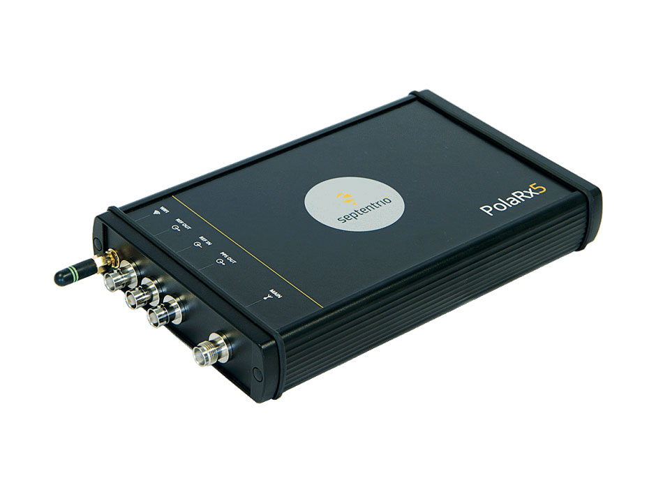
OSNMA anti-spoofing tech now on PolaRx5 GNSS reference receivers
Photo: Septentrio
Open Service Navigation Message Authentication (OSNMA) is now available on the high-end PolaRx5 reference receiver series. OSNMA offers end-to-end authentication on Galileo’s civilian signals, protecting receivers from GNSS spoofing attacks. OSNMA adds another layer of security to the receivers’ existing AIM+ anti-jamming and anti-spoofing technology. The PolaRx5 product range also now supports RINEX format versions 3.05 and 4.0.
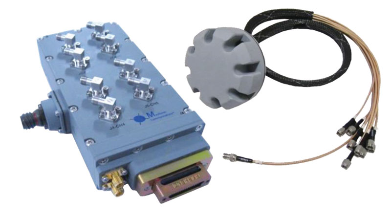
The MAGNA-F and MAGNA-I GPS anti-jam antennas provide simultaneous L1/L2 protection and can protect commercial and military GPS receivers on aircraft. The MAGNA products were developed with sponsorship by the U.S. Navy and further improved by the U.S. Army to support GPS protection requirements for air, sea and ground platforms, such as fixed-wing/rotary aircraft, ships, UAVs and tactical vehicles. The MAGNA-F uses a 3.5-inch-diameter controlled reception pattern antenna (CRPA) compatible with existing fixed radiation pattern antenna (FRPA) footprints. The MAGNA-I (NavGuard 730) is a high-performance yet small GPS anti-jam integrated solution with a 4.5-inch diameter FRPA-compatible footprint.
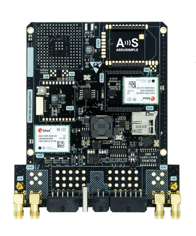
Centimeter-level GNSS for mass-market applications
Photo: ArduSimple
The SimpleRTK2B single-board computer (SBC) is built around up to three u-blox ZED-F9P high-precision GNSS receivers. It simplifies development of centimeter-level positioning solutions supporting real-time kinematics (RTK), making the technology accessible to broader audiences. The SimpleRTK2B-SBC was developed to make RTK technology as close to plug-and-play as possible. In addition to working as a stand-alone solution, customers can program their own applications with the company’s microPython API. The SimpleRTK2B-SBC delivers mechanical integration with centimeter position on three axes (heading, pitch and roll), outputting on NMEA, RTCM, RS232 and CANBus interfaces via Ethernet, Bluetooth, Wi-Fi and 2G/3G/4G communication. It offers configurable input/output and an inertial measurement unit.
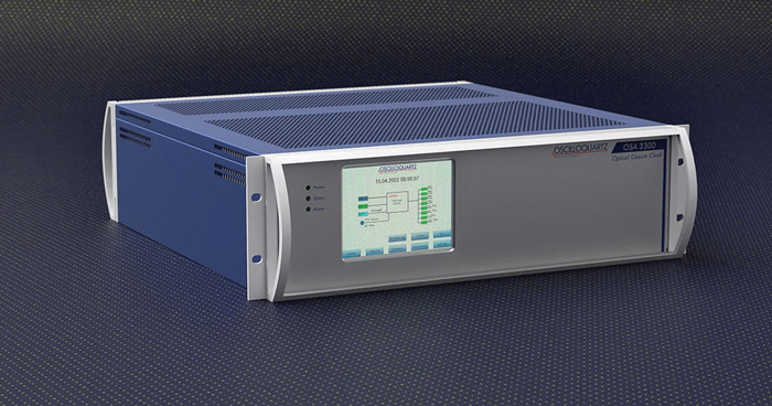
For assured positioning, navigation and timing (PNT)
Photo: ADVA
The OSA 3300-HP is a high-performance optical cesium clock with a 10-year lifetime compared to the five-year lifetimes of high-performance magnetic clocks. It provides the resilience required for PNT assurance in critical infrastructure and empowers service providers to deliver differentiated service-level-agreement timing offerings with integrated GNSS backup. The OSA 3300-HP has embedded Ethernet- and IP-based management as well as a user-friendly touchscreen graphical user interface.
With M-Code capabilities and upgrade paths for other GNSS systems
Photo: Collins Aerospace
NavHub-200M is a vehicle navigation system for the international market with military code (M-code) receiver capabilities. NavHub-200M provides assured positioning, navigation and timing (APNT) while improving overall resistance to threats to GPS, such as jamming and spoofing. Its message formats and signal modulation techniques ensure faster and more accurate performance for ground vehicles on the connected battlespace, while advanced security features prevent unauthorized access or exploitation. NavHub-200M also includes the open interface standards and sensor-fusion capabilities required for a GNSS upgrade path, such as that for Europe’s Galileo constellation, as well as the ability to interface with key vehicle sensors such as the inertial measurement unit (IMU) and odometer.
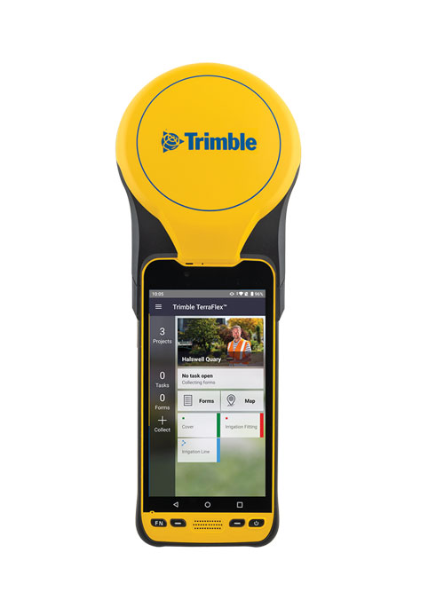
The Trimble TDC650 handheld is built for data collection, inspection and asset management activities. The rugged solution provides scalable high-accuracy GNSS positioning for professional field workflows, including apps such as Esri ArcGIS Field Maps and Trimble TerraFlex software. The TDC650 is scalable, allowing customers to choose their desired accuracy down to the centimeter level.
Powerful solution for manned and unmanned aircraft
Photo: YellowScan
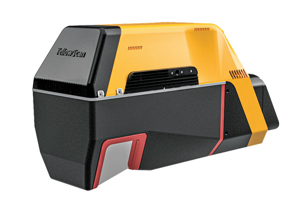
The Voyager long-range lidar scanner has a wide field of view, with all points collected oriented toward the ground so there is no loss of points. In all, 1.5 million points per second will be usable. Voyager combines a Riegl VUX-120 laser scanner with a Trimble Applanix AP+ 50 AIR or Applanix AP+ 30 AIR GNSS-inertial board, providing a precision of 0.5 cm and an accuracy of 1 cm. Voyager’s detection and processing of up to 15 target echoes per laser pulse allows for excellent vegetation penetration. It has an extremely fast data-acquisition rate of up to 1,800 kHz, suitable for projects requiring the highest point density. The laser scanner’s specifications can be customized and can be combined with YellowScan’s software solutions.
Extends 3D Tiles Next workflow into Esri ArcGIS Pro
Photo: ArcGIS
The 3D Environments Add-In application for Esri ArcGIS Pro allows ArcGIS users to rapidly transform 3D Tiles Next data formats, such as One World Terrain, into ArcGIS Pro projects to create 3D scenes from 2D vector data and 3D models. The add-in leverages Presagis’ building templates and texture libraries that analysts use to create enhanced 3D visualizations of GIS environments, helping increase collaboration across the enterprise. The 3D Environments Add-In contains tools to create, transform and extract a wide variety of 3D formats to provide seamless interoperability between ArcGIS Pro and modeling and simulation applications. It is available on the Esri ArcGIS Marketplace.
Energy performance data helps tackle climate change
Photo: XMAP
Municipal geographic information system XMAP can now incorporate the energy-performance ratings of individual properties to help local authorities tackle climate change, improve housing standards, and ensure landlords comply with legislation. The Energy Performance Certificate (EPC) data layer uses a rating system similar to the one used on new appliances, ranging from A (very efficient) to G (inefficient). It allows tenants and house buyers to make informed decisions. In addition to a color-coded visualization of current ratings, the XMAP EPC layer contains enhanced analysis including generalized ratings and the potential for improvement. Bath and North East Somerset Council, UK (pictured), has embraced this resource and is looking at how the data can be used to raise housing standards.
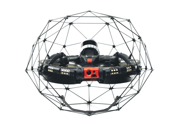
The Elios 3 is a collision-tolerant drone equipped with a lidar sensor for indoor 3D mapping. The drone is powered by a new SLAM engine called FlyAware that lets it create 3D models as it flies. It also hosts a new version of Flyability’s software for inspectors, Inspector 4.0. The Elios 3 comes with an Ouster OS0-32 lidar sensor, allowing inspectors to collect data for the creation of survey-grade 3D models using Connect software from Flyability’s partner GeoSLAM. Protected by a cage, the Elios 3 has advanced collision-tolerance features that allow inspectors to fly it inside dangerous confined spaces such as boilers, pressure vessels and mines.
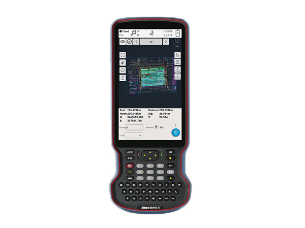
The R60 is a powerful handheld with an ergonomic design. It runs on Android 12 OS, providing a suitable workhorse for surveying professionals in the field. Survey Master field software works seamlessly on the R60, which features a Qualcomm 8-core processor for massive data processing. Its 64-GB memory allows ample data storage and enables the opening of CAD drawings in seconds. Other features include a QWERTY keyboard, a 5.5-inch sunlight-readable high-resolution screen, an IP67 rating (dustproof and waterproof), and a 9,000 mA Li-ion battery for more than 30 hours of continuous functioning.
The Mobile Centimeter (MobileCM) Space Weather Station is a ready-to-use GNSS device that will act as a real-time kinematic (RTK) base station and collect space weather data. The device is pre-configured to securely connect with the Global Earth Observation Decentralized Network (GEODNET) using a home Wi-Fi network. The full four-constellation GNSS base station has built-in NTRIP server functionality and is packaged with a survey-grade triple-band roof antenna and required cables.
The SAgro10 GNSS guidance system is an entry-level guidance system for precision agriculture, providing users with higher navigation precision and higher productivity, which can be upgraded to an automatic steering system. Embedded with a high-precision GNSS module, the SAgro10 system tracks all four global constellations. For users with network coverage or a UHF base station, the system provides centimeter-level accuracy navigation in real-time kinematic mode. In the absence of base stations, the SAgro10 system provides sub-meter navigation accuracy in single-point smoothing mode. Compatible with most agricultural tractors, its components can be installed within 15 minutes. The 10-inch sunlight-readable touchscreen has a clear and simple graphic interface.
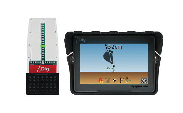
iDig 3D Connect is a solar-powered excavator guidance system with a GNSS receiver that can be removed and used as a rover, rather than permanently installed on the machine. 3D excavator guidance has seldom been used for small projects such as house foundations because of the need for a surveyor to stake out points and map a site. The removable receiver enables contractors to complete these tasks. The software provided creates a GNSS-generated site map, enabling precision digging relative to the area and making the process quicker, simpler and more eco-friendly than with 2D.
The Cloud Locator service takes data from LoRa Edge-enabled devices and uses Semtech’s LoRa Cloud Geolocation and Modem services for asset tracking both indoors and outdoors. It features built-in serverless technology and enables testing of ultra-low-power asset tracking on either a private or public LoRaWAN network. It is designed to work with trackers using Semtech’s LoRa Edge LR-series chips. The LR-series chips combine Wi-Fi and GNSS to obtain the latitude and longitude of devices in any indoor or outdoor location. Once configured on the service, together with Semtech’s LoRa wireless radio frequency technology for transmission to the cloud, customers can view the tracker location on a map in less than 15 minutes.
The Edge 1040 bike computer features solar charging and multi-band GNSS technology. Its multi-band GNSS receiver (GPS, GLONASS and Galileo) provides accurate positioning in challenging ride environments, such as dense urban areas or under deep tree cover. Advanced navigational tools help cyclists stay on track, such as turn-by-turn navigation and alerts that notify riders of sharp curves ahead. Route guidance and off-course notifications can be paused for exploring and turned back on for return to the original route. When using the Trailforks app, Forksight mode automatically displays upcoming forks in the route and where a rider is within a trail network.
Skydel 22.5 is a significant software upgrade to the Skydel simulation product line. It features advanced hardware-in-the-loop (HIL) testing solutions providing very low to zero effective latency. Enhanced visualization tools can monitor internal latency through real-time curves showing when the data is generated and sent to the RF signal. Users can also review the transmission of HIL packets for optimizing the entire network’s latency, checking its stability (jitter), and that data is available and used at the right time in Skydel. HIL testing is an essential step in the verification process of the model-based design approach because it involves all the hardware and software that will be used operationally.
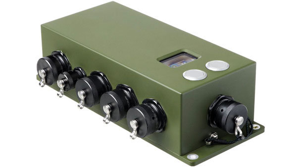
The Time-Loader is designed for defense and mission-critical applications, for deployment in environments where GNSS signals are denied or disrupted. It supports any ground, naval or airborne system that needs real time of day (TOD) and 1PPS external synchronization aligned to the UTC or GNSS. It generates a GPS L1 C/A code RF output as if the signal were coming from a live-sky GPS antenna. It provides full-constellation GPS output and is compatible with external GNSS receivers. Its GPS-disciplined oscillator (GPSDO) is the Microsemi MAC-SA53/55, which provides excellent UTC accuracy with outstanding hold-over rubidium clock performance. A self-contained, miniature GPS simulator provides real-time extremely accurate signals. The 18-channel full-constellation simulator stores location/time/date data in internal memory and stores complex vector data to simulate dynamic scenarios. The simulator also can be used to transcode NMEA or SCPI position/ velocity/time (PVT) data into GPS RF signals.
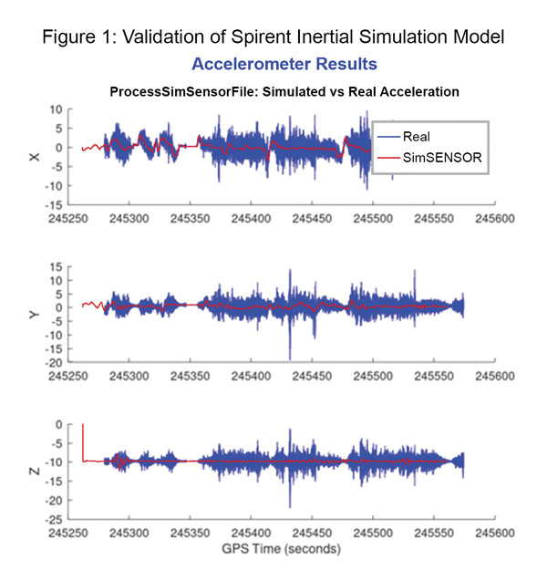
Data shows how successful baseline validation testing of Spirent’s inertial simulation model as compared to real world inertial system performance. Photo: Spirent Federal Systems
We discussed complementary PNT with Roger Hart, head of engineering and Jeff Martin, head of sales at Spirent Federal.
What are some of the most promising approaches to complementary PNT sources and how does simulation technology help?
Roger Hart: The vulnerabilities of GNSS have been recognized. Legacy GNSS are all operating on pretty much the same frequencies and power levels, so, they have some significant common vulnerabilities. There is great interest in finding ways to complement or even replace those capabilities.
Dead reckoning, magnetic and inertial systems have been around for a long time. There are emerging markets to make use of alternative radio frequencies for navigation. In some cases, we are piggybacking on communications signals and deriving PNT from them. In other cases, we are using new PNT signals. A couple that we’ve been focusing on are the alternative navigation systems.
They may be using different orbits, different frequencies, different encoding schemes that set them apart from the legacy GNSS systems, so that, used together, they provide greater resiliency and even stand alone when one or the other system may be affected by interference.
Not to be forgotten is inertial navigation. It’s been around for a long time and is still a standard of navigation. Together with GNSS, it makes it a terrific navigation system. It almost defines complementarity because where GPS is vulnerable inertial can fill in the gaps and where inertial drifts GPS does not. So, paired, they make a very strong system.
At Spirent, we’ve been working with customers to provide a variety of options for both those alternative navigation systems and inertial. Both are a very active field of development and we’re keeping abreast of that.
Jeff Martin: Some good points, Roger. This is something we’ve been engaged in for quite a long time. Since we provide test equipment to the community, it’s critical that we understand what they’re worried about, what the vulnerabilities are. It keeps things exciting, it keeps us on our toes and looking ahead to what’s coming.
What are some of the remaining challenges of integrating GNSS receivers with inertial sensors and, again, how does simulation technology help with that?
Hart: Inertial works by integrating sensor measurements that come in. Therefore, any errors that are present just accumulate over time and can corrupt your navigation solution. So, there’s a strong focus on updating error models and on translating them so that everyday users can use them and get real-life-type performance out of them.
There’s a tendency to think of integrating GPS-INS as putting everything together in one box. There are packages that do that. However, the push now is to go to more distributed systems that are integrated but not packaged in the same box. One example is the all-source positioning and navigation standard that is being developed by the Department of Defense. It will allow you to swap one sensor for another as long as they adhere to the standard. That information all goes back to a sensor fusion engine.
Martin: We have known GNSS simulators well for about four decades. We have been playing in the inertial sandbox for at least a couple of decades as well. This has given us the opportunity to build relationships with the with the key manufacturers and designers of inertial systems. Those relationships have been expanding well beyond inertial to many other sensors and systems that are now coming online. It’s been exciting.
Much work is going into using low Earth orbit satellites for PNT—whether piggybacking on the Iridium satellites or launching new ones. How does simulation help with that?
Hart: It certainly helps with the development of the receivers. The groups that are using these alternative RF and LEO or MEO systems need simulation as they develop the receivers. It gives you the ability to try things certainly before you launch them. At this conference there is considerable interest in making things reprogrammable. We have the NTS-3 satellite, which will be running experiments for different waveforms that can be generated. Even M-code is a step in the direction of giving more flexibility to the signal. It has a lot more flexible cryptography and signal generation than the legacy system with the C/A and P/Y codes.
Our simulation platforms are software based, so we can generate and receive data that can be useful for developing software-defined receivers. It gives you the opportunity to try different waveforms. We have already delivered a satellite-based alternative navigation system simulator. Now, we can build on that one to help the other Leo constellations as they come forward.
Martin: Roger put it well. This is where things get fun. People are concerned with PNT vulnerabilities, so we’re seeing these alternative navigation solutions coming forward. Spirent has done a good job over its nearly 40 years of existence of manufacturing and designing its own hardware and software. It has given us the opportunity to respond quickly. These things are coming fast. People need solutions quickly. We have some solutions already and the platform that we have created gives us the flexibility to develop more. We’re seeing more and more ideas come to fruition and people need to test them. So, this is where it gets fun. We’re excited.
Much work has gone into addressing the enduring challenge of urban canyons. How does simulation technology help?
Hart: Urban canyons are the worst nightmare for GNSS signals. If you’re surrounded by tall buildings, signals are blocked. You may have few or even no satellites in a direct line of sight and many multipath reflections. So, diminished and corrupted signals are available to you. Of course, the more GNSS satellites you have, the better chance you have of getting good signals. But complementing that are radar and vision systems. Those are the ones that will stand out, particularly the vision systems that can read the street signs, see where the curb is, look for parked cars. All those kinds of things will help fill in when you have poor GNSS coverage.
You can observe what’s going on in the environment and simulate it. You can also use our forecasting tool to look ahead.
Martin: This is where things get exciting, isn’t it? In these terrible environments where GNSS is contested—whether it’s an urban environment or one with intentional jamming—there is a lot we can do to help our industry. When this happens in real life, it’s bad news. But when you create that scary situation in the controlled environment of a laboratory, it is great. You can pick things apart and see where you need to improve. I get excited about it. It’s probably the geek in me. It gives us and our partners a lot to look forward to.
How does simulation technology help with sensor fusion?
Hart: It definitely helps you put all the pieces together. You can’t know how your system will work by individually testing each piece. System is the key word here. Simulation enables you to generate the signals and bring them together into a sensor fusion engine. You can test different algorithms. It’s certainly much cheaper and quicker than trying to build this into a product and then test it. Over the decades, simulation has proved itself as a very valuable way in both basic development and integrating the final product.
Martin: That system-wide fusion is where the magic happens.
It sounds like simulation technology—and Spirent Federal in particular—are very much at the center of a lot of the current developments and discussions about complementary PNT. Do you have any final comments?
Hart: As Jeff said, it’s an exciting time. There are many things going on—new technologies, new ways of communicating. It’s a busy time and a bit of a scramble sometimes to keep up with all the new things that are coming.
Martin: People look to Spirent to be their testing resource and it puts us right in the middle of it.
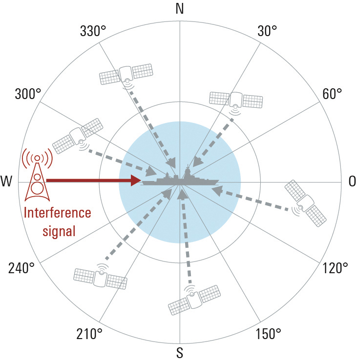
Interference-free GNSS signals are essential for more than just military vehicles and aircraft. Anti-jam systems usually suppress signals from interference sources by means of spatial filtering.
These solutions can likewise be used to protect satellite navigation signals for autonomous driving and flying against interference signals. To allow GNSS receivers to detect interference sources and suppress transmitted interference signals, they must be designed as multichannel systems.
This way the direction of the interference signal can be determined using phase-coherent signal processing of signals from multiple antennas, and the interference can be suppressed. Rohde & Schwarz offers a solution for the verification of interference immunity and interference suppression.
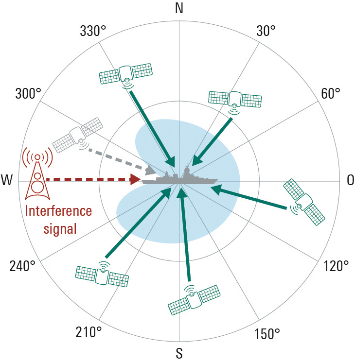
FIGURE 1a. The GNSS antenna in the example on the left has only one element, so its characteristic cannot be modified. A sufficiently strong interference signal can prevent the receiver from processing the GNSS signals, making satellite-based navigation impossible.FIGURE 1b. In contrast to the individual antenna, the characteristic of the antenna array can be modified by combining and weighting the received signals. The interference signal is suppressed at its angle of arrival, and the GNSS signals can be received. A disadvantage is that GNSS signals from the same direction as the interference signal are also suppressed.
Multi-channel receivers can simultaneously process signals from multiple distributed antennas or from an antenna array. This is useful for determining the direction of incoming signals by means of signal analysis, and for adjusting the antenna pattern so that undesired signals are suppressed. For GNSS-based position determination, this means that signals from global navigation satellite systems (GNSS) can be strengthened and jamming or spoofing signals originating from the ground or the air can be suppressed. Up to now this technology has primarily been used for military applications, but in the future it can also make an important contribution to robust navigation for autonomous driving or flying. Typical interference sources in this regard are harmonics of transmitters in the vicinity, tactical air navigation (TACAN) signals, DME air navigation signals for civil aviation, and LTE signals. Another factor is the growing popularity of so-called personal privacy devices (PPD), which are GNSS jammers that radiate narrowband or broadband signals to disrupt GNSS localization. A new solution from Rohde & Schwarz enables comprehensive testing of the resistance of GNSS receivers to interference signals, if necessary in a realistic hardware-in-the-loop (HIL) environment.
Multi-Channel GNSS Receivers for Interference Suppression
GNSS receivers often use controlled reception pattern antennas (CRPA) to suppress undesired signals. These antennas consist of an antenna array and a signal processing unit. The connected antennas are generally arranged in a strict geometric pattern to achieve full coverage of all possible signal directions. The overall receive characteristic of the antenna array can be altered by suitable weighting of the signals from the individual antennas in the signal processing unit (Fig. 1). This way, interference signals can be specifically blanked out (nulling) or the required GNSS signals can be amplified at their angle of arrival (beamforming). A combination of these two methods is also possible. The antenna arrays typically consist of four to seven elements. The number of interference signals that can be simultaneously suppressed increases with the number of elements.
FIGURE 2a. A four-channel GNSS test system consisting of two R&S SMW200A vector signal generators and an R&S SMA100B analog signal generator for the LO signal (left). The vector network analyzer is used to calibrate the overall system at a user-selectable reference plane in terms of amplitude, phase and propagation time.FIGURE 2b. A four-channel GNSS test system consisting of two R&S SMW200A vector signal generators and an R&S SMA100B analog signal generator for the LO signal (left). The vector network analyzer is used to calibrate the overall system at a user-selectable reference plane in terms of amplitude, phase and propagation time.
Test System Requirements
Rohde & Schwarz offers a test system for GNSS receivers that use CRPAs. First, it acts as a multichannel GNSS simulator that considers all aspects of a satellite navigation system. It must be able to generate the signals of all standard satellite navigation systems in all GNSS frequency bands, with attention to correct satellite orbits, signal propagation characteristics and realistic modeling of the dynamically changing receive environment. Configuration of the antenna array in terms of geometry and the receive characteristics of the individual antennas also must be included.
Simulating the Interference Signals
Second, the system can simultaneously generate jamming or spoofing signals in order to test the interference suppression functions of the device under test (DUT). A second, identical test system is necessary for freely definable configuration of interference sources with very high transmit power. Here the R&S Pulse Sequencer software assists in the definition of complex interference scenarios. The scenarios cover requirements such as long simulation times, moving interference sources and GNSS receivers, user-defined antenna patterns and antenna scans. In addition, the software calculates the correct amplitude, phase angle and propagation time of the signals as a function of signal frequency, antenna arrangement, and the positions of transmitters and receivers in three-dimensional space for each individual antenna element. Signal generation is handled by the R&S SMW200A high-end vector signal generator.
For the tests, the required GNSS signal as well as the unwanted interference signals must be generated for each antenna input of the GNSS receiver. In order to test a CRPA receiver with four antenna inputs, this means that four signal sources are needed to generate the GNSS signals and an additional four signal sources are needed to generate the interference signals. Fig. 2 shows a pair of test systems that can be used to generate coupled GNSS signals and interference signals for a four-channel CRPA receiver.
Calibration Against the DUT
In order to correctly simulate the directions of the satellite signals and the interference signals, the test systems must be calibrated at the RF interface to the DUT with regard to amplitude, phase and propagation time. This means that the amplitude, phase and propagation time differences between the individual RF paths, resulting for example from cables or RF components, must be compensated. The vector signal generators of each system are phase coherently linked using suitable synchronization. A high-end R&S SMA100B analog signal generator in each system provides the shared LO signal.
Using the R&S RF Ports alignment software, the complete system can be calibrated at any desired reference plane with regard to amplitude, phase and propagation time, so that the properties of the test system do not corrupt the simulated signal differences between the individual antennas. The required measurements are performed with a vector network analyzer.
It is not necessary to calibrate the two test systems relative to each other. For the simulation of realistic scenarios, it is sufficient to run the GNSS and interference source simulations at the same time, since in the real world there is usually no correlation between GNSS satellites and interference sources.
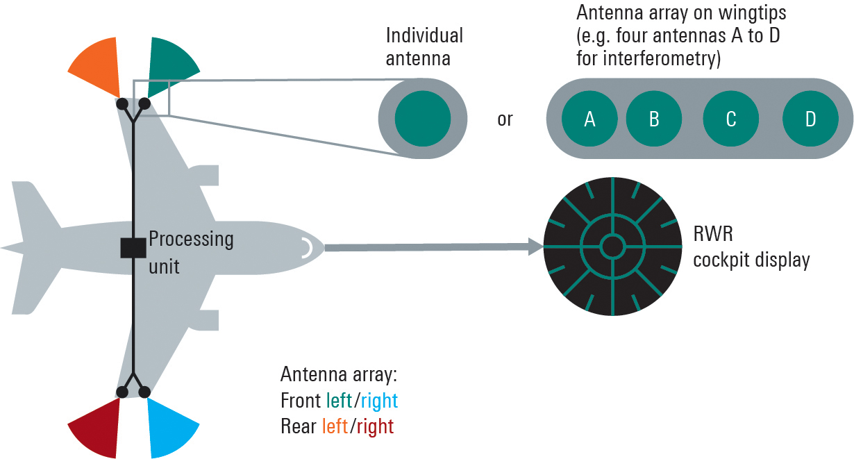
FIGURE 3. Aircraft with a multichannel radar warning system consisting of multiple receive channels, a central processing unit and a display.
Integration in an HIL Environment
The GNSS test system also can be embedded in a hardware-in-the-loop (HIL) environment. In this case a computer streams the motion profile of the GNSS receiver under test, with position, speed, acceleration and vehicle attitude, to the test system at a high data rate. The test system then generates the corresponding satellite navigation signal in real time. This requires very high update rates and low latencies.
Summary
Multichannel GNSS CRPA receivers considerably improve the navigation of ground vehicles and aircraft of all kinds. With the new Rohde & Schwarz test system, realistic multi-channel test signals can be generated for both GNSS simulation and interference simulation. For tests in an HIL environment, motion data also can be streamed to the GNSS test system.
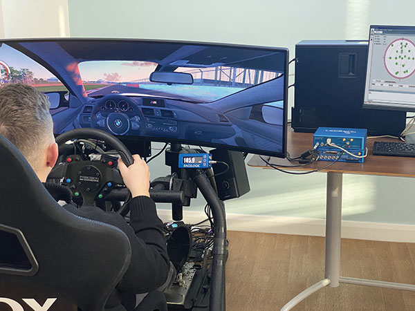
An off-the-shelf PC provides the computing power for complex GNSS driving simulations. (Photo: Racelogic)
By Julian Thomas Managing Director, Racelogic
Driving simulators are commonly used by vehicle manufacturers to expedite the test and development process of their many electronic systems. This not only saves the considerable time and expense of using a real car on a test track, but it is, of course, significantly more environmentally friendly.
LabSat simulators are used by many leading technology companies and car manufacturers to develop and verify the performance of their new products containing GNSS receivers. These tests are performed using either a pre-recorded or an artificially generated RF signal. This RF signal contains the combination of multiple satellite signals, which are decoded by the GNSS engine, tracking the artificial satellites as though they were real. Static or moving scenarios can be generated, and the user can select parameters to suit their own application, such as time, date and available constellations.
Julian Thomas Managing Director Racelogic
Recently, an automotive LabSat customer had a specific requirement to synchronize a GNSS receiver with the real-time trajectory data generated by one of their driving simulators. This was for a hardware-in-the-loop test rig where a human driver would navigate a route around a virtual test track, while the normal electronic systems reacted as if the vehicle were being driven around a real environment.
The challenge in this customer’s application was that the time delay between the trajectory coming from the simulator and the generation of the corresponding GNSS signals had to be less than 100 ms. This low latency was necessary to achieve realistic synchronization between the driver’s inputs and the resulting output from the GNSS-based device under test.
Traditionally, low-latency real-time simulators use bulky expensive hardware that relies on power-hungry field programmable gate arrays (FPGAs) to create the necessary satellite signals. However, due to the inevitable tick of Moore’s Law, and with some clever optimizations, your entry-level desktop PC now packs more than enough punch to simulate multiple constellations and signals with very low latency.
Using a standard PC to do the heavy lifting means that the hardware required to output the simulated signal is much easier to obtain, can be a lot simpler, and is considerably more cost effective. For example, an 8-core, 3-Ghz Intel i7 processor can generate the signals from 20 satellites in real-time, which normally is sufficient to simulate all but the most complex scenarios.
Our LabSat SatGen software has been continuously developed and optimized during the past 15 years, so it did not take us long to enable the reception of an NMEA trajectory stream with a latency of less than 100 ms. We then streamed this simulated data via USB to our LabSat Real-Time, which generated a corresponding RF signal that can be connected directly to the RF input of any modern GNSS engine.
Using a PC to generate the signals does not mean a loss of fidelity, with the resulting output achieving a repeatable position of less than 10 cm, while the trajectory data can be received at up to 100 Hz.
The resulting solution can take trajectory data from any kind of simulator that has an API to obtain real-time data, such as many popular off-the-shelf driving and flight software simulators, and use this to provide a real-time signal that can be utilized by the GNSS device under test.
Our future development roadmap includes synthesizing external signals, such as CAN-based sensors or inertial measurement units, and then synchronizing these signals with the incoming trajectory. With the amazing power of a modern PC, we are finding that this kind of complex simulation is now much more cost effective and easier to achieve.
Program will support positioning, navigation and timing (PNT) research at colleges and universities around the world
Orolia has created the Orolia Academic Partnership Program (OAPP) to build a community to help foster global PNT research and collaboration at top engineering schools and research institutions.
Orolia will provide qualified institutions with access to the company’s signature Skydel GNSS simulation engine, an advanced GNSS and PNT testing and simulation tool.
Webinar scheduled
Orolia will host a webinar on Dec. 14 at 11:00 a.m. EST to introduce OAPP and answer questions about the program and Skydel. Register here.
Orolia also created an online forum to support its vision to form an interactive community focused on the future of GNSS and PNT research and education.
The forum allows users to interact with other users and Orolia experts, share information, ask questions and receive feedback. A host of white papers, application notes and detailed technical documents are also available.
The Skydel platform
Skydel is an innovative GNSS simulation platform that leverages software, advanced graphics cards and software-defined radios. Users can build custom signals and connect to other systems and devices (such as sensors and inertial measurement units) through Orolia’s open-source plug-in capabilities.
Skydel also includes the ability to generate and test the vulnerability of GNSS/GPS with integrated interference, jamming and spoofing capabilities. Because Skydel leverages commercial off-the-shelf hardware, it can run independently of simulation vendors’ hardware.
“Skydel platform’s versatility and capabilities allow users to perform tests in the field, in the lab, and at home — whether you are running a turnkey system provided by Orolia, our partners, or through your own proprietary hardware,” said Lisa Perdue, director, PNT Testing and Simulation at Orolia. “Unlike other GNSS simulators, Skydel is the only professional platform offering a plug-in architecture that provides real-time and direct access to the core simulation engine. This plug-in architecture unlocks a new range of application and customization that is impossible to imagine with traditional instruments.”
Perdue added that plug-ins can be shared with the open-source community to leverage all the benefits from a collaborative ecosystem. “We believe this modern architecture is the perfect approach to support academic research as well as allowing users to go further into system integration and customization,” she said.
The University of Stuttgart in Germany is an academic partner. (Photo: Regenscheit, Universität Stuttgart)
Stuttgart Institute a Pioneer
More than 40 schools throughout North America, Europe, South and Central America and Asia-Pacific are enrolled in OAPP, including the Institute of Navigation (INS) at the University of Stuttgart in Germany, where Skydel is fueling pioneering student research.
“Skydel allows our students to carry out complex field tests, such as simulating laboratory scenarios in real time and using radio hardware to send signals to commercial or self-developed receivers,” said Thomas Hobiger, INS. “We can compare our navigation solutions with the simulated trajectories while showing the absolute accuracy of our algorithms, meaning the deviation from the actual position.”
Hobiger added the INS wants graduates to be well-prepared for the demands of the industry and future innovation. According to Statista consumer research, the installed base of GNSS devices worldwide stood at 6.4 billion units in 2019. The Asia-Pacific region led the way, accounting for 3.4 billion GNSS devices, with forecasts suggesting this is set to rise to 5.1 billion devices by 2029.
“OAPP members can contribute to this community to share their advancements, upload code or make their work available to others in our GitHub repository,” Perdue said. “The goal is to ensure that members can access ideas and expertise of other users across the globe.
“The need for continuous and reliable GNSS signals as well as methods to protect those signals from jamming, spoofing or meaconing is growing exponentially worldwide,” Perdue said. “These are the main reasons why engineering students should gain valuable experience using a platform that provides accurate PNT simulation and measurement.”
Simulator vendors explain their evolution in response to changes in GNSS/PNT, comment on technical challenges they face, and outline principal markets.
GNSS receivers — which were never as simple as FM radio receivers or garage door remote controls — are becoming increasingly complex. The causes for this include continuing efforts to:
reduce their size, weight, and power (SWAP)
utilize new signals from up to four GNSS constellations
integrate them with other sensors, such as inertial measurement units (IMUs), cameras, and lidars
take advantage of a growing number of public and private, global, regional, and local correction services
meet the requirements of booming new markets, such as autonomous vehicles
mitigate the threats posed by the proliferation of unintentional and intentional RF interference, the latter better known as jamming, and by spoofing.
In short, receiver manufacturers must constantly adapt to a GNSS/PNT landscape that is, as one of the respondents to this Q&A put it, “ever evolving.”
In turn, the growing complexity of GNSS receivers requires increasingly sophisticated simulators to test receivers and their integrations in controlled conditions before field testing and deployment. Increasingly, this is achieved by replacing with software what was once done in hardware. Simulation remains a vital, though often underappreciated, segment of our industry.
On the following pages, five simulator vendors briefly explain their evolution in response to changes in GNSS/PNT, comment on the principal technical challenges they face, and outline their principal markets.
Spirent Federal Systems’ GSS6450 RF record and playback GNSS simulator is portable, for testing automotive applications in the field. (Photo: Spirent Federal)Lisa Perdue Product Line Director, Simulation Orolia
OROLIA
How has your approach to simulation changed over the years and in response to what changes in GNSS/PNT?
We have transitioned away from the GNSS simulator approach of using fixed, allocated hardware that we used in our early simulators to the more modern software-defined approach we use today. Given the ever-evolving PNT landscape, it is difficult to design hardware that will support all future GNSS and PNT simulation needs. Instead, we focus on the development of the Skydel software platform, which can then be used with the supported COTS hardware or turnkey system to generate the necessary signals. This gives us the benefit of maximum scalability and flexibility while being truly future proof.
The software-defined approach also allows us to offer Skydel in new and exciting ways. We aim to make PNT simulation accessible to everyone and we can do that through subscription and cloud-based simulation services.
What are currently the greatest technical challenges to GNSS/PNT simulation?
Today GNSS is only a part of the PNT picture. GNSS receivers are often tightly integrated with other sensors and many times the GNSS receiver cannot be isolated to test it on its own. Other sensors must also be stimulated or simulated and included as part of testing. Correction services are becoming more common, but many are proprietary with no public specification. With no common standards available, it can be technically challenging to create a one-size-fits-all test solution.
We tackle these challenges through our plug-in feature. The plug-in architecture allows you to expand the capabilities of Skydel by adding your own features or complex integration with other systems. It allows you to exchange information with the Skydel Engine and even integrates it into the Skydel UI. With our open-source SDK, which includes example plug-ins, you can create your data outputs synchronized to the GNSS simulation, such as IMU or correction services data.
In what markets and applications are your simulators used? Are they used only in labs or also in the field?
At Orolia, we say ‘Skydel Everywhere.’ Skydel is used in applications ranging from military encrypted receiver testing (SAASM, M-Code, PRS) to commercial applications supporting any of the GNSS signals available.
Skydel is used in systems that are found in labs, but you can also find Skydel at an individual engineer’s desk, or even home offices. In the field, Skydel has provided simulation and threat generation capability to authorized test ranges and field test events.
The broadsim software-defined GNSS is powered by Orolia’s Skydel GNSS simulator engine. (Photo: Orolia)
RACELOGIC
Julian Thomas Managing Director Racelogic
How has your approach to simulation changed over the years and in response to what changes in GNSS/PNT?
Over the years, GNSS technology has changed significantly but our approach of identifying a need and creating a solution hasn’t changed since we launched our first LabSat GNSS simulator. We created LabSat because we needed a cost-effective, accurate and easy to use record and replay simulator that we could use for product development and production line testing for our VBOX Automotive and VBOX Motorsport technologies. This need could not be met by any other simulator manufacturer, so we developed our own solution, which in turn became LabSat. Although our approach has not changed, the needs of users, including our own engineers, have, so we continue to develop and improve LabSat to meet these needs.
With the increasing number of satellite launches in market segments such as communication and navigation, the number of requests for testing space-qualified receivers has increased dramatically. To test these kinds of scenarios, we have been making some major upgrades to simulate rocket launches and Earth orbit trajectories that require very different characteristics from land-based simulation.
As the number of constellations and signals has expanded very rapidly, the number of simultaneous signals that need to be simulated has put a far greater requirement on the computing power needed to render them. We have been working very hard on optimizing our routines to make the most of the new breed of high-performance multi-core processors. The result has been a big decrease in the time taken to create a scenario, and an increase in the number of signals that can be simulated in real-time.
What are currently the greatest technical challenges to GNSS/PNT simulation?
The biggest challenge is in simulating a large number of constellations and signals in real-time without using dedicated, expensive hardware to create them. The good news is that with the latest Intel Xeon processors boasting up to 40 cores and 80 threads, a much larger number of signals can now be created in real-time using off-the-shelf PC components.
In what markets and applications are your simulators used? Are they used only in labs or also in the field?
With the global pandemic causing national lockdowns, many engineers switched to working from home. Our largest growth in the simulator market has therefore been due to providing these engineers with a small, low cost, easy to use simulator that they can have on their desks at home, allowing them to continue to develop GNSS applications without having to go into the office. The markets these engineers work within are as varied as the markets that use GNSS technology.
We have also seen a big increase in the use of our simulators to test mass produced satellites used in providing global internet coverage. These satellites are being produced in large volumes, and the need for a low cost, reliable testing method on the production line has driven strong growth in this area.
Our simulators are often used in the field to gather data for in-lab testing, as small size and battery life are very important factors in this environment.
SPIRENT FEDERAL SYSTEMS
Phillip Bonilla Senior Systems Engineer
How has your approach to simulation changed over the years and in response to what changes in GNSS/PNT?
Spirent has provided highly accurate simulation solutions since the early phases of GPS availability, starting with defined hardware for each signal type. As the GNSS landscape has grown, Spirent has worked closely with leading developers, adding key flexibility and functionality to adapt and provide a growing product portfolio. By adopting a robustly defined system architecture, and employing signal-agnostic hardware, Spirent simulators can generate any of the available constellations and frequencies, with no more than a few clicks of a mouse.
While broadening the support for the increasing number of constellations has been a focus, so too has the necessity to provide users with high numbers of available channels and auxiliary simulation needs. To complement GNSS simulation, significant effort is being devoted to resilient application testing, providing users with flexible solutions for introducing jamming and spoofing to the test environment. Our agnostic hardware supports signal generation using software defined radio (SDR), including interference sources and user-defined IQ signal data. As customer demands have grown, alternative RF and PNT sensors have been—and continue to be—incorporated, allowing users an expanded and comprehensive test environment.
The new spirent simulator generates alternative RF navigation signals concurrently with GNSS signals. (Photo: Spirent Federal)
What are currently the greatest technical challenges to GNSS/PNT simulation?
Today, nearly all industries rely on GNSS or other PNT sources to some extent. With such varied and widespread use, laboratory testing is critical, and maintaining the highest levels of accuracy, reliability and robustness remains one of the greatest challenges. For modern hardware-in-the-loop configurations, simulation systems must be able to keep latency consistent to enable powerful post-processing of results. With this challenge in mind, we at Spirent design and manufacture our own hardware, ensuring precision and ultra-low latency.
Another significant test challenge posed by modern applications is the growth in vehicle speed and maneuverability. Creating a truly realistic test environment for supersonic and even hypersonic vehicles with high rates of spin and jerk places huge demands on a simulator. Spirent recently has introduced the industry’s first 2 kHz update rate, enabling the most accurate trajectories for the most mobile technologies.
Lastly, positioning engines are becoming more complex. In addition to GNSS and inertial, vision systems and a range of other sensors and signals-of-opportunity are providing developers greater opportunity for precision and robustness. Therefore, a core part of Spirent’s mission statement is delivering test equipment that is designed to be integrated into wider test benches and ensuring that equipment is always orders of magnitude more accurate than any device under test.
In what markets and applications are your simulators used? Are they used only in labs or also in the field?
Spirent simulators are used in all phases of the product life cycle across nearly all applications. Receiver manufacturers use our solutions beginning with initial research and development, throughout product development, and well into production and field testing. Along with the ability to use Spirent’s simulators for live range testing, Spirent’s GSS6450 record and playback system enables users to record the real world in high dynamic detail for repeatable lab testing.
JACKSON LABS
Gregor Said Jackson President and CTO
How has your approach to simulation changed over the years and in response to what changes in GNSS/PNT?
Initially, we saw a large demand for GPS-only solutions. We are shipping units into this market and it is growing more than 30% year over year for us. Recently, customers are looking to also supporting other constellations. There is an emerging market for LEO simulation capability. Many LEO constellations are becoming reality, such as OneWeb, Kuiper, Starlink, Iridium, Xona, and others, and customers are more frequently asking if we can support these types of signals in our simulators. Demand also is arising for additional base-band signals to accommodate the RF signals, such as synchronized raw IMU data and other observables. Jamming and spoofing signals also are being requested and reproducing these as faithfully as possible is a big challenge for synthesized simulation. Lastly, we see demand rising for mil-type secure applications, such as M-Code, PRS (Galileo) and P(Y) code SAASM of course. The complexity of future simulators will rise in lockstep with the complexity of the RF spectrum coming to us from space.
What are currently the greatest technical challenges to GNSS/PNT simulation?
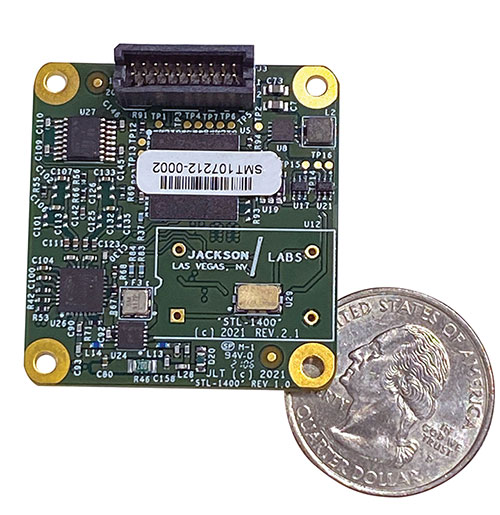
The STL-1400 positioning and timing receiver is designed for battery-operated low SWaP-C applications. (Photo: Jackson Labs)
A faithful reproduction of the real live-sky RF signals would rank high on this list. There are almost an unlimited number of out-of-band and in-band benign and adversary RF signals on a typical GNSS antenna these days, and more recently the sun has been acting up with solar flare activity that can disrupt GNSS signals. As GNSS receivers mature and become capable of tracking four, five or more carrier frequencies and constellations at once it becomes increasingly challenging to supply these types of signals from a simulator, and at a reasonable price-point. Sometimes, a wideband recording and playback system can do a better job at reproducing live-sky signals, however these systems are limited to playing back the same exact mission over and over again of course, and thus are not very flexible.
In what markets and applications are your simulators used? Are they used only in labs or also in the field?
Our simulators are built for two different applications: the first is a traditional type of GPS signal simulation where a Windows application allows a user to set up static or dynamic scenarios, allows them to upload NMEA playback files, create jamming or spoofing signals, and generally tweak the RF signal in many ways, such as modifying power levels and antenna patterns and even creating space vehicle failures in real time. Our customers range from car, aircraft, and avionics manufacturers, to R&D labs, to the government and academia.
Our simulators also are used for a hardware-in-the-loop application that we call transcoding. It allows glueless retrofitting of existing GPS equipment with any and all the emerging PNT solutions such as LEO positioning and timing, celestial navigation, INS/IMU, CSAC holdover, and concurrent/multi-frequency GNSS using a 1×1-in. transcoder module. Our transcoders fly on Air Force aircraft, are used to retrofit telecom equipment, and allow deep-indoors and underground GPS reception. Transcoders created an entirely new market for simulators.
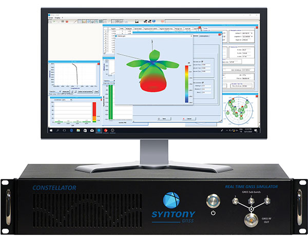
SYNTONY GNSS
Sylvain Daubas GNSS Simulators R&D Teams
How has your approach to simulation changed over the years and in response to what changes in GNSS/PNT?
Manufacturers of GNSS receivers are targeting more precision and availability, especially in urban areas, which require acquiring more signals from more constellations and greater effort to minimize multipath errors. This confirms that an SDR design for signal generation is decisive to keep systems cost-efficient, as it directly benefits from Moore’s law. For instance, our new RTGS4-12 configuration is about four times more powerful (240 channels) than our previous standard configuration, for a similar budget level.
Regarding precision and RF quality, our simulators benefit from the same RF cards as Echo, our high-fidelity record and playback equipment, with a state-of-the-art RF front end: three channels at a 100 MHz sampling rate and a 16 bit IQ. The capacity to simulate protected signals is also crucial: with PRN Link, Constellator is ready for any present or future signal with encrypted spreading codes.
What are currently the greatest technical challenges to GNSS/PNT simulation?
Building a CRPA simulator is not an easy task, as this requires extreme levels of phase and time synchronization between several RF outputs, typically four, seven or more. This can be done in two ways: with a dedicated new RF board running with a single synthesizer for all channels or using the classical one, to which one should add a complex calibration mechanism. SYNTONY has made the tough choice, investing more at first in a mono-synthesizer version. However, this will benefit our customers, for which the usage will be simplified and it will save them a lot of time by shortening the calibration phase. This version already is available for sale.
On another note, it is a significant challenge to keep our product and its interfaces user friendly while also enabling our clients to configure each of the more than 500 parameters available (at the last count). We also keep in mind that new signals may appear, from LEO constellations for instance, answering to new needs such as autonomous driving. Constellator is HW ready for them, only requiring a software update.
In what markets and applications are your simulators used? Are they used only in labs or also in the field?
Constellator currently is mainly used in laboratories, in many market segments. Because it was initially built in partnership with spacecraft manufacturers, it benefits from the high standards of performance of space industries and includes several advanced space-dedicated features.
On top of the typical usage inside the labs, two other SYNTONY simulator products that are directly derived from Constellator are used in the field:
ECHO Recorder & Playback is used to record the GNSS environment with ultra-high fidelity: today @ 100Mhz, and before the end of 2021 even up to @ 200Mhz. ECHO has been used by our customers in cars, trains and often in aircraft test flights. Another usage of ECHO is to detect and record scintillation phenomena, as we will soon do in Brazil.
SubWAVE (GNSS coverage extension for underground places) allows indoor positioning with precision, directly compatible with standard GPS receivers, which can be crucial for safety or operational reasons. We have installed SubWAVE inside subways stations and tunnels (for example, in Stockholm, Paris and New York), in road tunnels (soon in France, in the “Tunnel du Mont Blanc”), in an underground bus terminal (also in Stockholm), in underground train stations (in Switzerland), and before the end of 2021 also in an underground mine (in Finland).
Among the enhancements, a doubling of the update rate means the GSS9000 series now offers the ability to recreate operations more precisely and realistically, reducing uncertainty in positioning, navigation and timing (PNT) testing.
The latest developments provide the GSS9000 series with the ability to run simulations at a software and hardware update rate of up to 2 kHz, improving accuracy of the simulated trajectory without compromising performance. This is of particular benefit to high-dynamics applications, such as space missions and hypersonic vehicles. The increased update rate also delivers lower latency for hardware-in-the-loop (HIL) testing, further reinforcing the GSS9000’s position as the industry’s most accurate and realistic test instrument.
“Our dedicated hardware and powerful software solutions are built specifically with PNT test in mind — to improve accuracy, increase flexibility and provide high-performing systems to meet customer needs,” said Adam Price, Spirent director of PNT simulation. “These latest enhancements to the GSS9000 continue to raise the bar for highly flexible and scalable solutions that enable our customers to stay ahead of their competition.”
Other enhancements to the GSS9000 Series include:
Extended Scenario Duration. In a simulation environment, where control and repeatability are key for a realistic representation of the mission, reducing the number of user inputs is essential. The new update will extend the available scenario duration to 65 days, using the same initial conditions for the simulation throughout the duration of testing to deliver uninterrupted high-performance simulation for longer.
Enhanced Embedded Interference Capabilities. To provide greater power and flexibility in interference testing, Spirent has improved support for interference testing on wide spectrum signals, increased bandwidth resolution and repetition rates, and added variable bandwidth control on additive white Gaussian noise (AWGN).
“Spirent’s leadership in GNSS testing comes from the combination of our unrivalled heritage and deep understanding of the PNT market, alongside our continuing commitment to improving test capabilities for customers,” said Ricardo Verdeguer Moreno, product line manager for high-end applications. “By working closely with customers, we are able to better understand the challenges they face, and these latest enhancements to the GSS9000 series demonstrate how we are continuing to help customers reduce uncertainty by providing more accurate operations, without impacting system performance.”
The enhancements to the Spirent GSS9000 series will be available to new and existing customers at the beginning of the second quarter of this year. For more information, visit the GSS9000 Series product page. U.S. government and prime contractors should contact Spirent Federal for details.
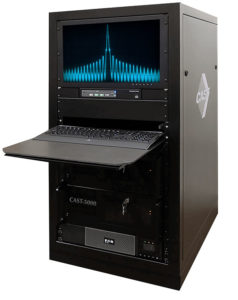
The CAST-5000 produces a coherent wavefront of GPS RF signals to provide repeatable testing in the laboratory environment or anechoic chamber. The basic system generates four independent, coherent simulations that reference a single point and is configurable to support up to eight elements for CRPA testing. With an intercard carrier-phase error of less than 1 millimeter, the CAST-5000 is extremely accurate.
The system generates a wavefront of GPS when its GPS RF generator cards are operated in a ganged configuration. Each generator card provides a set of GPS satellites coherent with the overall configuration. Several RF generator cards may be utilized together, ensuring phase coherence among the bank of signal generator cards. The CRPA antenna, antenna electronics and the GPS receiver can be tested as a unit with or without radiating signals.
The CAST-8000 is a new simulator that merges the CAST-5000 CRPA tester with a CAST-3000 EGI tester. The CAST-5000/8000 has the ability to be “ganged” together with additional CAST simulators to provide multiple vehicle and/or multiple antenna test configurations.
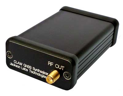
The 18-channel miniature full-constellation CLAW GPS Simulator is a fully self-contained, low size, weight, power and cost (SWaP-C) miniature GPS simulator. It is very popular in manufacturing environments as well as R&D applications that require consistent and repeatable local GNSS signals at low price points.The CLAW simulator does not require external computers for processing and control — it works fully self-contained by simply applying power, and storing location/time/date data in internal non-volatile (NV) memory, or by storing complex vector data to simulate highly dynamic scenarios. The CLAW also can be used to transcode NMEA or SCPI position/velocity/time (PVT) data into GPS RF signals. JLT offers an easy to use, highly configurable and cost-free SimCon Windows application program that is downloadable from the JLT website.
The SimConapplication allows random scenario generation and is thus usable to simulate leap-second events, week 1023 rollover events, or any other GPS live-sky scenarios including highly complex yet easy-to-create dynamic vector simulations. For authorized U.S. government users, a version that does not have altitude and velocity limitations is popular for low-Earth-orbit (LEO) simulations. Multipath simulation allows use of the entire 18-channel simulator capability. The unit can be field-upgraded with an easy to use in-field software upgrade feature. The CLAW is also very useful in GNSS receiver sensitivity testing for R&D or mass-production assembly lines as it allows accurate control of RF output power ranging from –100 dBm to less than –130 dBm with 0.1-dB resolution and typically better than 1-dB accuracy over the controllable power range.
The CLAW GPS Simulator also has a built-in RF signal generator with sweep, CW and random noise functions that are useful in simulating GNSS jamming scenarios, as well as GPS spoofing scenarios. The simulator comes in an FCC-certified metal desktop enclosure with numerous accessories.
The Orolia family of GNSS simulators offers a wide breadth and depth of tools for those responsible for mission-critical positioning, navigation and timing (PNT) applications. The simulation tools enable users to test a variety of scenarios, from simple to complex. Orolia’s simulators are feature-rich and easy to use, offering a way to harden GPS/GNSS-based systems without the limitations of testing from live-sky signals. Orolia’s approach allows users to buy only what they need today and upgrade later.
ESSENTIAL
Photo: Orolia
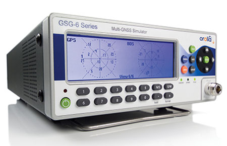
GSG 5/6. An essential scenario-based simulator used for testing a variety of smart applications such as drones, the internet of things (IoT), connected cars, cellular and more. GSG 5/6 offers ease-of-use with an out-of-the-box configuration and comprehensive set of pre-defined scenarios, plus the ability to create scenarios. It can simulate all constellations, all frequencies, and movements/trajectories anywhere on or above Earth. This enables a multitude of test solutions covering accuracies and sensitivities due to environmental conditions, technology factors and other events. Application packages are available for real-time kinematic (RTK), eCall, high-velocity, jamming and sensors.
ADVANCED
Skydel Software Engine. The software behind Orolia’s high-end GNSS simulators: GSG-8, BroadSim, BroadSim Anechoic and BroadSim Wavefront. All share the same software-defined benefits and interoperability. In addition to Orolia’s turn-key systems, Skydel can run on the user’s own commercial off-the-shelf (COTS) hardware. It is suitable to test and validate GNSS systems for a variety of applications, with advanced signal customization and configurable outputs. Users can create advanced scenarios with multiple parameters and variables: antenna patterns, orbits, multipath, hardware-in-the-loop (HIL) and more. The easy-to-use API configures all aspects, available in Python, C#, C++ and LabVIEW. User interactions can be recorded and exported as executable Python script — a learning tool that drastically reduces the automation learning curve.
Photo: Orolia
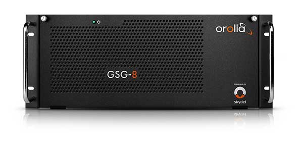
GSG-8. An advanced software-defined GNSS simulator supporting multiple constellations, frequencies and hundreds of signals all-in-view. With a 1000-Hz iteration rate, high dynamics and real-time synchronization, GSG-8 delivers ultra-high performance and flexibility. It is designed for space trajectories, custom PNT signals, HIL and more. Advanced jamming and spoofing options allow users to create benign and threat scenarios required for critical applications. Complex objects such as Differential GNSS (RTK), multi-antenna vehicles, attitude measurements and sophisticated GNSS receivers can be tested. A comprehensive software development kit (SDK) allows users to incorporate encrypted or proprietary signals. Powered by the Skydel Simulation Engine.
Photo: Orolia
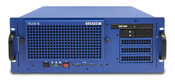
BroadSim. Available through Orolia Defense & Security, BroadSim was designed to meet the demand of NAVWAR testing. BroadSim supports high dynamics, advanced jamming and spoofing simulation tools, and encrypted military codes including Y-code, M-AES and M-MNSA. BroadSim uses a custom Linux operating system for security and better performance. BroadSim excels in NAVWAR applications due to its four independent RF outputs, a wide dynamic range with up to 0 dBm transmit power, and integrated jamming and spoofing scenario creation. BroadSim’s ease-of-use and functionality to configure multiple vehicles allows any user to seamlessly test the performance and vulnerability of their system without requiring a high level of expertise. Powered by the Skydel Simulation Engine.
Photo: Orolia
BroadSim Anechoic. Available through Orolia Defense & Security, BroadSim Anechoic enables users to accurately simulate over-the-air (OTA) GNSS environments in their anechoic chamber. Designed from the ground up for the user, by users, the system has 32 individual RF outputs enabling it to drive 16 dual-frequency antennas. The automation of antenna mapping, time delay and power loss calibration cuts set-up time from days to minutes. Easily verify signals with a built-in spectrum analyzer. The 48-dB transmit chain amplifier and 80-dB transmit chain dial attenuator allow for complete signal control and high dynamic range. Powered by the Skydel Simulation Engine.
Photo: Orolia
BroadSim Wavefront. Available through Orolia Defense & Security, BroadSim Wavefront enables fully featured testing of controlled reception pattern antenna (CRPA) and multi-element antenna electronic systems. Scaled upon the same easy-to-use software-defined platform and interface, it supports 4-16 antenna elements with integrated high dynamics and a phase coherence of 1° σ. Users can simultaneously simulate multiple spoofers, jammers, repeaters and alternate PNT sensors with just a few clicks. The Wavefront makes no compromise between the number of signals and the iteration rate, which remains at 1,000 Hz. It is designed to help engineers deliver results and make decisions, and can be calibrated in a matter of minutes. Powered by the Skydel Simulation Engine.
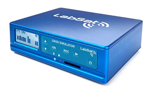
The LabSat 3 Wideband is a compact yet powerful multi-constellation and multi-frequency GNSS testing solution.
The easy-to-use, one-touch record and replay function provides an efficient way to test and develop GNSS-based technology without the cost and limitations of live-sky signals.
With simple-to-install upgrade options available, customers can invest with the confidence that its capabilities can grow alongside their future requirements.
LabSat 3 Wideband can record and replay up to three different channels at 56-MHz bandwidth across all major constellations and signals including:
GPS: L1/L2/L5
GLONASS: L1/L2/L3
BeiDou: B1/B2/B3
QZSS: L1/L2/L5
Galileo: E1/E1a/E5a/E5b/E6
L-band correction services including SBAS and IRNSS
2x CAN, RS232 and digital inputs tightly synchronized with GNSS data
Future signal launches are also supported, including L2C, L5 and L1C
LabSat 3 Wideband has a removable SSD (up to 7TB) and a two-hour runtime provided by an internal battery. It is lightweight and portable, making it ideal for field testing in any environment.
SatGen Signal Simulation Software
SatGen software allows users to quickly create bespoke, accurate scenarios with their own time, location and trajectory, that can be replayed via a LabSat GNSS Simulator.
The latest version of SatGen can be used to create a single scenario containing all the upper and lower L-Band signals for GPS, Galileo, GLONASS and BeiDou.
Precision-sensitive applications such as autonomous driving, control of unmanned aerial vehicles (UAV), or positioning of aircraft during landing procedures in coordination with ground-based augmentation systems (GBAS) require that modern GNSS receivers undergo detailed tests before implementation.
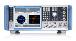
Rohde & Schwarz signal generators like the R&S SMW200A and the R&S SMBV100B offer a unique approach to generating complex and highly realistic scenarios for testing of GNSS receivers that are able to work with diverse navigational systems such as GPS, GLONASS, Galileo, BeiDou and QZSS/SBAS signals. Both simulators can emulate them all for testing.
R&S SMW200A. The R&S SMW200A GNSS simulator (pictured above) can be used to produce complex interference scenarios with multiple interferers — all generated within the instrument itself. It can emulate up to 144 GNSS channels and can be equipped with up to four RF outputs. With its ability to simulate multi-constellation, multi-frequency, multi-antenna and multi-vehicle scenarios, the R&S SMW200A is able to cover a variety of high-end GNSS applications.
R&S SMBV100B. The R&S SMBV100B supports the same navigational systems, with access to 60 GNSS channels and one RF output, with the same ability to configure realistic scenarios including obscuration, multipath and atmospheric effects, as well as the specific characteristics of the antenna and the simulated vehicle. An integrated noise and CW interference generator also can be added.
Since the devices do not require an external PC for scenario configuration, all the tests can be created quickly through the user-friendly GUI. Due to all-encompassing instrument options available, both simulators can be set up to fit unique user requirements.
For testing GNSS receivers under controlled and repeatable conditions, the R&S SMW200A and the R&S SMBV100B provide extensive and cost-effective solutions. The platforms are ready to adapt to future requirements and testing of newly implemented GNSS signals.
GSS9000, SimMNSA, CRPA test system, anechoic chamber testing, mid-range testing
Photo: Spirent Federal
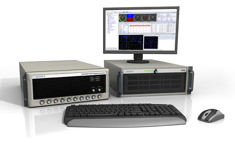
Spirent Federal provides GPS/GNSS test equipment that covers all applications, including research and development, integration/verification and production testing.
GSS9000. The enhanced GSS9000 Multi-Frequency, Multi-GNSS RF Constellation Simulator is Spirent’s most comprehensive simulation solution. It can simulate signals from all GNSS and regional navigation systems and has a system iteration rate (SIR) of 1000 Hz (1 ms), enabling higher dynamic simulations with more accuracy and fidelity. The GSS9000 supports restricted/classified signals. Users can evaluate the resilience of navigation systems to interference and spoofing attacks, and have the flexibility to reconfigure constellations, channels, and frequencies between test runs or test cases.
SimMNSA. The first fully approved MNSA M-code simulator. Authorized users of the GSS9000 series of simulators will be able to utilize the advanced capabilities of SimMNSA to create more robust solutions for their customers. SimMNSA has been granted Security Approval by the Global Positioning System Directorate.
CRPA Test System. Spirent’s Controlled Reception Pattern Antenna (CRPA) Test System generates both GNSS and interference signals. Users can control multiple antenna elements. Null-steering and space/time adaptive CRPA testing are both supported by this comprehensive approach.
Anechoic Chamber Testing. Spirent’s GSS9790 Multi-Output, Multi-GNSS RF Constellation Wave-Front Simulator System is a development of the GSS9000. The GSS9790 is a unique solution providing the core element for GNSS applications that require a test system that can be used in both conducted (lab) and radiated (chamber) conditions.
Mid-Range Solutions. Spirent also offers solutions that cater to intermediate GPS/GNSS testing needs. The GSS7000 multi-constellation simulator provides an easy-to-use solution for GNSS testing that can grow with users’ requirements. The GSS6450 RF record and playback system enables replay of a real-world GNSS/GPS test repeatedly in the lab.
High-end GNSS simulation solutions for R&D, integration and production testing
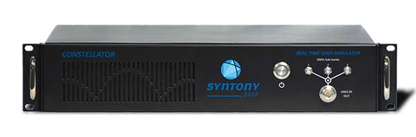
Photo: Syntony GNSS
Constellator. Syntony’s GNSS simulator Constellator supports all constellation signals available and provides a high level of service in different ranges. It covers, in a single unit, a wide spectrum of use cases from entry-level with L1C/A up to very demanding configurations such as multi-frequencies and 400 channels management.
Extensively used in aeronautics, space and defense industries, Constellator answers complex requirements:
Standalone mode (on the ground and in space)
Multi-frequencies
All constellations and their signals, including NavIC/IRNSS
Hardware in-the-loop (HIL) mode with zero-effective latency and 1000-Hz update rate
All typical synchronization interfaces
Particularly in the space industry, Constellator implements the advanced models (Earth gravity, drag, 3D ionospheric models, side lobes, etc.) needed to achieve accurate simulations for all kinds of orbits (from LEO to GEO and SSTO). Combined with other Syntony GNSS simulation products (interference generator, Recorder & Player Echo, GBAS simulator, etc.), Constellator can be used to tackle challenging use cases such as jamming, spoofing, multipath, and multiple antennas testing. Constellator is based on a software-defined radio (SDR), making it hardware-ready for future constellations, signals and codes. It is easily upgradeable and versatile.
GNSS Recorder & Player. Syntony’s Echo is an ultra-high-fidelity GNSS recording and playback solution. It is designed to capture real-life signals and environments, for instance from airplanes, and then replayed for R&D or production tests. Echo offers:
3 RF channels of 100-MHz bandwidth each (for the whole set of GNSS signals from all constellations)
16-bit resolution (I&Q)
from 7 to more than 1,000 hours of record/replay capabilities depending on configuration
Echo-R can also record complex and very long realistic scenarios from a simulator; Echo-P can replay them with very high fidelity for long-run or production tests. Please ask Chief Sales Officer Francois Goudenove for distributor contacts in the U.S., Europe, India, China, South Korea and Japan.
Averna celebrated its 20th anniversary Sept. 20 as a test and quality solutions provider. Founded in 1999 by a team of three in Montreal, Quebec, Averna has grown to 400+ employees with 10 offices and more than 300 customers around the world.
“I am proud to see what Averna has become,” said Adil Lahlou, one of the co-founders of Averna. “We started Averna by understanding our clients’ manufacturing challenges and now reflecting on the continuing success we’ve had, it’s a reminder that we are still on the right path, particularly with the growth of Industry 4.0.”
Averna’s growth can also be attributed to business alliances. Company founders Kurt Hensen (T&M Solutions NV) and Darren Lingafeldt (Nexjen Systems) both believed that combining more than 100 years of test and quality experience would only benefit their customers and the industry.
“With each company bringing their own expertise to the forefront, different technologies are being exposed to a wider range of clients internationally,” the two said in a press release.
With proficiency in vision, RF signals, optics, precision assembly, robotics and automation, Averna has developed hundreds of unique solutions to service major industries such as medical technology, automotive and transport, and consumer goods and electronics.
Through standalone projects and complete program outsourcing, Averna’s global team has demonstrated its capability to support their customers at every step of the product life-cycle, the company said.
“What makes Averna outstanding is the willingness to consistently evolve and stay in front of our customers’ business needs,” said Francois Rainville, president and CEO of Averna. “It’s our employees’ enthusiasm to understand and tackle customers’ evolving requirements that has kept us ahead for the last 20 years and will continue to through the next 20.”
Updated GSS9000 Series takes a bow, joining range of test solutions on show
The Enhanced GSS9000 Series GNSS constellation simulator. (Photo: Tyler Gunter)
Spirent Communications will unveil its enhanced GSS9000 Series GNSS constellation simulator at ION GNSS+ 2019 in Miami, which will take place Sept. 16–20. It joins Spirent’s already impressive range of test solutions on display at the world’s largest showcase of GNSS technology, products and services.
“The industry is at a very important point,” said Spirent Marketing Director Steve Hickling. “With the volume of GNSS signals growing, more multi-constellation receivers being developed every day, and the need for greater precision increasing all the time, it’s vital that testing solutions are able to stay ahead of this reality. This is why we’re excited to demonstrate the enhanced GSS9000 Series at ION.”
The GSS9000 Series constellation simulator has been improved with enriched features and enhanced capabilities combined with an increased channel capacity. Most importantly, this greater flexibility, coherence, fidelity, performance, accuracy and reliability is maintained under all test conditions.
At ION, Spirent (booth E) will also be showing its GSS6450 — the highly portable 16-bit RF record and playback system — and the GSS7000 series multi-frequency, multi-GNSS RF simulation solution. Visitors can also learn more about Spirent’s realistic multipath and obscuration simulation tool, the new Sim3D.
Spirent’s expertise will also be demonstrated during three ION GNSS+ speaking panels: