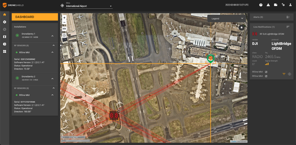
DroneSentry-C2 with Nearmap location data. (Screenshot: DroneShield)
DroneShield Limited, an Australian/U.S. global leader in artificial-intelligence-based platforms for protection against advanced threats such as drones and autonomous systems, has announced an enhanced version of its DroneSentry-C2 command-and-control software in partnership with location intelligence firm Nearmap.
Nearmap provides city-scale 3D content, artificial-intelligence data sets, geospatial tools, and high-resolution aerial imagery in Australia, New Zealand and North America.
DroneSentry-C2 provides an intuitive and feature-rich software platform, providing counter-UAS awareness and reporting capability. It integrates both DroneShield and third-party C-UAS sensors and effectors. Those include multiple AI-enabled sensing and tracking products, such as RfOne long-range direction-finding sensors for UAS detection and tracking, and camera-agnostic DroneOptID optical/thermal camera AI software.
DroneSentry-C2 will come with a standard mapping solution for cost-sensitive customers, and an optional Nearmap mapping upgrade for mapping data for markets requiring high performance, such as government, intelligence, Homeland Security and defense.
The software comes as an on-premises, air-gapped solution for intelligence, Homeland Security and defense users, or secure cloud for enterprise customers. The on-premises solution also includes a high-grade physical server. Both options come with regular mapping updates, including the ability for the user to load their own maps for sensitive locations.
“One of DroneShield’s differentiators is that we are both a sensor manufacturer and an integrator,” said Oleg Vornik, DroneShield CEO. “Providing a streamlined and standardized hardware / software bundle that gives our user community an easy-to-deploy and run command-and-control software will be critical as more fixed and pop-up site users seek to deploy counter-UAS products. Importantly, the offering is already validated by deployments such as U.S. Air Force and Australian Army, among a number of other tier 1 end users globally.”
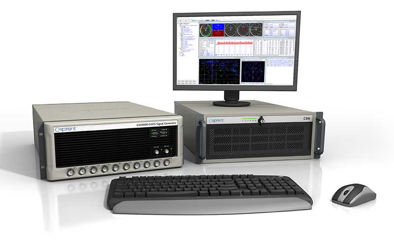
GNSS simulator company Spirent Federal Systems will soon release SimMNSA 2.0. The release adds advanced scenario controls that enable full recreation of government test vectors while retaining the simple key and fly option of the initial release.
Spirent Federal developed software that supports M-code signals using the Modernized Navstar Security Algorithm (MNSA). SimMNSA 1.0 was released in 2018 and is now used in laboratories throughout the country with receivers from all M-code manufacturers.
“SimMNSA is the first MNSA-based M-code signal simulation to receive government security approval,” said Ellen Hall, President and CEO. “We pride ourselves in being leaders in innovation and we will continue to push ourselves to meet the growing needs of our customers.”
Release 2.0 of Spirent Federal’s SimMNSA is scheduled for later this year. It will be available to authorized users of the GSS9000 Series, at no additional cost to current SimMNSA users under maintenance contracts.
Helps enable state and municipal government agencies to improve fleet operations and increases operational efficiencies
Photo: THEPALMER/E+/Getty Images
Geotab, an Internet of Things (IoT) and connected transportation company, has launched its Geotab Public Works solution in North America.
The all-in-one solution offers fleet managers full visibility into the operational data of all government vehicle types on a single platform,and provides the toolsets to effectively remain compliant, reduce costs and maintain road safety.
Designed to help government agencies better manage vehicles such as salt spreaders, snowplows, street sweepers and waste management vehicles, the Geotab Public Works solution is integrated with an extensive number of spreader controllers.
The solution is built to support key government business drivers including material management, compliance, accountability and liability. Providing public works departments with improved fleet management capabilities, fleets can utilize the solution to more accurately measure material usage, such as salt, allowing government fleet managers to feel more confident that community roads are not over- or underserviced.
With Geotab Public Works, government fleets are better able to control costs while reducing the impact that excessive material usage can have on the environment.
“Empowered by an industry-leading number of spreader controller integrations alongside various geospatial capabilities, the Geotab Public Works solution is designed to help government fleets optimize both their seasonal and ongoing fleet operations,” said Chris Jackson, associate VP of Business Development, Public Works and Smart Cities. “Spreader controllers provide fleet managers with rich insights that can help government agencies ensure that their fleets are adequately servicing roads without sacrificing the health of the environment.”
Available as a configurable add-in on the MyGeotab platform, the Geotab Public Works solution allows governments, including municipalities of all sizes, to customize their database to help meet the specific needs of their fleet.
In addition, users can add further value and customization through access to the Geotab Marketplace, an extensive portfolio of mobile apps, software add-ins and hardware add-ons that enable Geotab customers to further customize the fleet management solution.
“As many governments continue to look for ways to optimize their operations, Geotab Public Works is the type of robust, scalable, secure solution that provides real value by giving government fleet managers and local constituents unprecedented visibility to their public services,” said Jean Pilon-Bignell, vice president of Business Development, Government and Smart Cities at Geotab. “With high-frequency, near real-time reporting, the Geotab Public Works solution allows governments to know where their fleets are and how they are operating at all times, enabling fleet managers to more efficiently leverage their fleet data to provide better and more transparent services to their residents.”
Aerial imagery company Nearmap has acquired technology and assets from Pushpin, a deep learning and analytics technology company that extracts data from 3D models to provide roof geometry insights to a variety of sectors including roofing, solar and government.
The technology acquisition allows Nearmap to rapidly extract and disseminate roof geometry from its wide-scale 3D models and offer a new form of location content to its customers.
‘‘By acquiring Pushpin’s 3D geometry extraction technology and pairing it with our rich data, we bring the best of both worlds together at unprecedented scale’’ said Rob Newman, Nearmap CEO. “Over the past couple of years, we’ve evolved our offering from 2D imagery to a multi-product portfolio, and this acquisition is an important milestone in our approach to continue adding new content types for our customers. This addition aides our company mission by providing 3D geometry data at unmatched speed, thereby changing the way our customers perform their work.”
With this new technology, Nearmap can provide a semi-automated calculation and extracted representation of any roof geometry within an hour, significantly reducing turnaround time. The combination of Nearmap’s 3D content and Pushpin’s geometry extraction technology opens up a diverse range of use cases, enabling businesses to fast-track job estimation, determine solar irradiance, plan drone delivery routes and model 5G propagation.
“The addition of Pushpin’s 3D geometry extraction technology into our large-scale 3D reality models will enable us to further evolve our offering and produce at scale roofing geometry,” said Tom Celinski, Executive Vice President, Technology and Engineering at Nearmap. “With the added ability to provide roof geometry data, we will be able to provide even deeper insights on what’s happening on the ground, and help businesses and government organizations transform the way they work and do their job more efficiently.”
The roofing and solar industries are poised for significant growth. Currently, 1% of the United States population has solar panels on their homes. According to the Solar Energy Industry Association (SEIA), total U.S. solar capacity will more than double over the next 5 years.
Additionally, a significant number of U.S. residential homes have their roofs replaced every year due to roof damaging storms and changes in roofing trends and material. This new product offering from Nearmap is poised to significantly impact these markets, as companies are expanding their use of technology to assist with tasks such as roof material and project quoting through reports, project management through roofing specific software, and customized sales and marketing tools for the roofing industry.
Deployed service members may have to ditch their fitness trackers in response to a new memo from Deputy Defense Secretary Patrick M. Shanahan prohibiting the use of GPS functions in deployed locations.
This includes physical fitness aids, applications in phones that track locations, and other devices and apps that pinpoint and track the location of individuals.
Pentagon spokesman Army Col. Robert Manning III announces the policy on geolocation devices at the Pentagon, Aug. 6, 2018. (Photo: DoD/Jim Garamone)
“Effective immediately, Defense Department personnel are prohibited from using geolocation features and functionality on government and nongovernment-issued devices, applications and services while in locations designated as operational areas,” Pentagon spokesman Army Col. Robert Manning III told Pentagon reporters on Aug. 6.
Deployed personnel are in “operational areas,” and commanders will make a determination on other areas where this policy may apply.
The market for these devices has exploded over the past few years, with many service members incorporating them into their workout routines. They use the devices and applications to track their pace, running routes, calories burned and more. These devices then store the information and upload it to central servers where it can be shared with third parties. That information can present enemies with information on military operations.
Using GPS Devices Pose Risk
Photo: Fitbit
“The rapidly evolving market of devices, applications and services with geolocation capabilities presents a significant risk to the Department of Defense personnel on and off duty, and to our military operations globally,” Manning said.
The GPS capabilities can expose personal information, locations, routines and numbers of DoD personnel. Their use in overseas locations “potentially create unintended security consequences and increased risk to the joint force and mission,” Manning said.
Personal phones and other portable devices also contain apps that rely on GPS technology, and they will be affected. Commanders will be responsible for implementing the policy, and they will be allowed to make exceptions only after conducting a thorough risk assessment.
Security is at the heart of this guidance. DoD seeking a balanced way that allows for legitimate official and personal uses of geolocation technology that does not impact security.
Manning said the department will continue to study the risk associated with these devices and change the policy as needed.
GPS World magazine recently conducted the 2018 State of the Industry survey, an online polling of the GNSS community. It has become an annual feature, probing for the technical and business challenges that are drawing attention this year, how executives, managers and product developers are driving business in today’s economy, what issues they are concerned about, and — always — what solutions hold the most promise for positioning, navigation and timing (PNT) in challenged and indoor environments, regardless of which technology provides them?
This column reports on the answers provided by those who identified themselves as working in the Defense, Security and Government (DSG) sector of the GNSS/PNT industry, and speculates on the insights that can be drawn from the answers.
Among all who took the survey, 18 percent said they worked in Defense, Security and Government, the second largest group among eight industry sectors, following only Survey and High Precision in size. Of the DSG group members, 82 percent were based in the United States, 6 percent each in Europe and Asia-other-than-Russia-China-and-Japan, and 4 percent from Latin America. Slightly more than half of them worked in companies of more than 500 people.
Queried as to job title, they answered as follows:
Owner/president/co-owner/CEO: 8 percent
Vice president, CTO, COO, CFO or similar: 6 percent
General Manager: 2 percent
Product or program manager: 10 percent
Researcher: 12 percent
Engineer: 44 percent, the largest group
and Other: 18percent, with this last category encompassing consultants, cartographers, a security architect systems engineer, and more.
Each sector group taking the survey answered two questions specific to their sector, while also responding to a variety of economic and systemic questions for the industry as a whole. In the DSG group, the specific questions were:
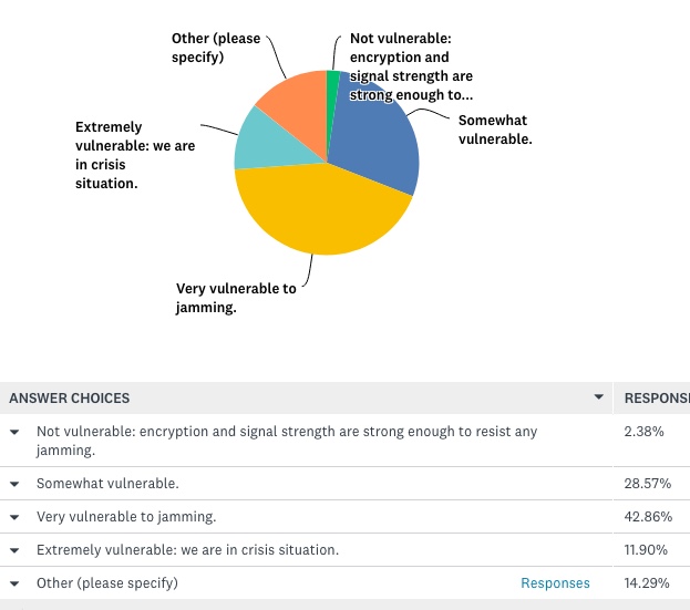
How vulnerable is GPS/GNSS in defense/security/critical government applications, that is, M-code or similar, to disruption by jamming, whether intentional or unintentional?
And:
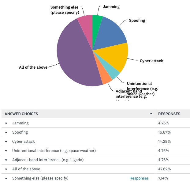
What is the greatest threat to GNSS over the next three years?
The answers to vulnerability appear here:
Source: GPS World 2018 State of the Industry survey
And the answers to threat here:
Source: GPS World 2018 State of the Industry survey
Perhaps we erred in offering an “All of the above” answer, as nearly half of respondents selcted that option. This shows a generalized awareness (and fear) of threats, but lacks the capability to then prioritize those threats.
Delving a little further into the responses from the DSG sector, when asked “What technology will win fully enable seamless outdoor/indoor navigation, in combination with GNSS,” they answered:
Assisted GNSS 8.57 percent
Assisted GNSS plus any ONE of the six other answers (Cell-tower triangulation, Proximity beacons, Radio frequency pattern-matching, Sensor-based dead reckoning, Terrestrial ranging system,Wi-Fi 22.86 percent
And the winner: Assisted GNSS plus MORE THAN ONE of the six alternatives 34.29 percent
With Don’t Know, 17.14 percent, and Other, 8.57 percent.
More than any other solution an integration of at least three sensors, in the opinion of the plurality, will be necessary for ubiquitous positioning and navigation.
First choice for a GNSS back-up? The leading answer was eLoran, at 25.71 percent, followed by Low-Earth orbit satellite constellations, 22.86 percent, and Sensor-based dead reckoning, 17.14 percent.
How much effort are you devoting to mitigation of GNSS jamming and/or spoofing?
This is the leading concern of out research and development effort 40 percent
This is an important concern for our R&D, but not the dominant one 20 percent
This is one among many factors we consider; no particular importance above others 17.14 percent
And very surprisingly: We are not focusing on jamming/spoofing mitigation at all at this time 22.86 percent
Finally, describe the market for GNSS products/services in the Defense, Security and Government PNT industry sector as of today.
Very healthy; strong growth 25.71 percent
Relatively healthy; moderate growth 48.57 percent
Flat 22.86 percent
Slightly down 2.86 percent
For more results from the 2018 State of the GNSS Industry, see this page.
DJI has launched a new Local Data Mode that stops internet traffic to and from its DJI Pilot app, providing enhanced data privacy assurances for sensitive government and enterprise customers.
Local Data Mode will be available in the next update on the DJI Pilot app on CrystalSky and for select Android tablets.
When an operator activates Local Data Mode, the app will stop sending or receiving any data over the internet. This adds an additional layer of security for operators of flights involving critical infrastructure, governmental projects or other sensitive missions.
“We are creating Local Data Mode to address the needs of our enterprise customers, including public and private organizations that are using DJI technology to perform sensitive operations around the world,” said Brendan Schulman, DJI’s vice p resident of policy and legal affairs. “DJI is committed to protecting the privacy of its customers’ photos, videos and flight logs. Local Data Mode will provide added assurances for customers with heightened data security needs.”
Since Local Data Mode blocks all internet data, the DJI Pilot app will not be able to detect the location of the user or show map and geofencing information such as No Fly Zones and temporary flight restrictions, nor will it notify drone operators of firmware updates.
Telemetry data on flight logs such as altitude, distance or speed will remain stored on the aircraft even if the user deactivates Local Data Mode.
Whether Local Data Mode is activated or not, photos and videos captured by the user are always stored on the drone’s SD card and are only shared if the user chooses to upload them online to the SkyPixel community, social media or other websites.
When using Local Data Mode, drone operators are reminded that they are solely responsible for the safety of their flight operation and that they understand that features that may enhance and support the safety of their operations, but that rely on internet connectivity, are no longer available.
Drone operators can enable Local Data Mode by opening the DJI Pilot app, clicking on “Activate LDM Mode” and entering a password which will be required to deactivate Local Data Mode when they decide to go online again.
New drones will still have to be activated first by logging into the user’s DJI account with an email and a password. To ensure the drone has the latest firmware, users can download and update it while they have internet connectivity before re-activating Local Data Mode.
The Local Data Mode feature may not be available in locations where an internet connection is required or highly advisable due to local regulations.
Organizations work together to fight cyber attacks with innovations to visualize threats.
Esri and the U.S. Department of Energy’s Idaho National Laboratory (INL) have entered into a cooperative research and development agreement (CRADA) to collaboratively research and create prototype concepts with a specific focus on location intelligence solutions for the protection of critical infrastructure and critical missions.
The work will also estimate the impacts on critical infrastructure caused by exploited cyber vulnerabilities and targeted attacks.
Esri provides geospatial analysis and visualization capabilities across infrastructure industries like water, electric, oil and transportation, as well as in support of federal, state and local governments charged with the mission of protecting those industries.
These capabilities, combined with INL’s knowledge and capabilities for securing these systems from physical and cybersecurity threats, make this cooperative research and development effort truly unique in addressing crucial gaps in cyber/physical analysis and situational awareness technologies.
INL is the nation’s leading center for nuclear energy research and development, working in energy, national security, science, and the environment. Esri and INL have worked together for more than three years.
“We are looking forward to working closely with INL in this capacity,” said Brian Biesecker, technical director, Esri intelligence community. “As the government continues to embrace new technologies, CRADAs provide a great way for private and public partnerships to continue moving our country forward.”
Rockwell Collins and QinetiQ have signed a global alliance agreement to collaborate on the development of next-generation, multi-constellation open-service and secure GNSS receivers.
The effort will support the mission needs of military, government and critical national infrastructure.
The family of receivers being developed will provide military, government and professional users the flexibility of selecting relevant GNSS capability to meet operational, geographical or budgetary needs and provide GNSS accuracy and timing.
This will improve safety, increase mission effectiveness and reduce operational costs for ground troops, vehicles and high-dynamics GNSS-guided weapons, Rockwell Collins said.
Rockwell Collins is major contractor for secure military GPS receivers and QinetiQ is an expert in the field of open-service solutions with access to critical satellite navigation system technologies that enable the development of multi-constellation solutions.
“This alliance agreement with QinetiQ is a great opportunity to bring together our strengths,” said Colin Mahoney, senior vice president of international and service solutions for Rockwell Collins. “Working together, our customers will experience unprecedented levels of availability, accuracy and assurance of positioning, navigation and timing for conducting their missions.”
“As we move into the era of multi-constellation satellite receivers, this market-leading agreement and the investments of both companies sends a clear message to our customers and shareholders that QinetiQ and Rockwell Collins are taking every step necessary to stay at the forefront of GNSS technical development and product delivery,” said Steve Wadey, CEO of QinetiQ. “The development will be centered in Europe, led from the U.K., supporting the global market.”
TerraGo is partnering with CompassTools, a provider of integrated GIS, GPS and wireless solutions for field data collection across numerous industries, including government, utility, natural resources, transportation, architecture and construction.
“We help our customers build the best bundled solution for their GIS and GPS goals, whatever they may be, and TerraGo’s mobile solutions give us the flexibility we need for the wide spectrum of accuracy, workflow and data collection requirements,” said Andrew Carey, manager of Geospatial Solutions at CompassTools. “TerraGo provides out-of-the-box integration for all the leading platforms, while enabling customizable precision, basemaps, forms and workflows, which fits well with our customer-focused approach.”
“CompassTools helps organizations identify and implement the best combination of GPS receivers, hardware and software to meet their unique requirements,” said John Timar, vice president, Worldwide Sales, TerraGo. “TerraGo Edge and TerraGo Magic were designed from the ground up to support that type of customization; which makes it easy for customers to get the benefit of CompassTools’ expertise to help them deploy a solution tailored to their mission.”
TerraGo is hosting a webinar on Tuesday, Feb. 14, at 12 p.m. ET with a live demonstration of mobile GIS and GPS solutions available from TerraGo and CompassTools.
Global mapping company Esri is partnering with Waze to make it easier for governments to begin building intelligent transportation systems in their communities.
Waze enables users to share and harness the power of anonymous, aggregated data to promote greater transportation efficiency, deeper insight into travel conditions, and safer roads.
Governments already using the Esri ArcGIS platform can quickly and easily exchange data through the Waze Connected Citizens Program, a free two-way data share of publicly available traffic information.
Governments that have not already subscribed to Esri technology or joined the Waze Connected Citizens Program can sign up online to start sharing road closure alerts and other information with their citizens right away.
Waze Esri Traffic Alerts.
“Municipalities can now leverage real-time reports without having to invest in sensor networks or an Internet of Things infrastructure,” said Andrew Stauffer, manager of civic technology at Esri. “Waze allows local governments to share open data with a purpose — in an application that is already popular with constituents, commuters, and tourists.”
The data feeds allow local governments to merge information into existing enterprise systems, such as emergency dispatch and street maintenance systems, to make their communities operate smarter and safer.
The partnership also enables communities to extend the reach of the data they map and manage by sharing it with Waze, which has more than 65 million monthly active users worldwide. The public-private partnership allows greater government transparency and collaboration with citizens to help people better navigate their streets and highways.
“The Waze Connected Citizens Program empowers municipalities to harness real-time driver insight to improve congestion and make better informed planning decisions,” said Paige Fitzgerald, head of new business development and data acquisition for Waze. “With 100 partners worldwide, Waze provides each partner with the same set of free, data-driven tools and resources to foster collaboration and communication between all partners. Working with Esri allows Waze to further scale the program and creates additional opportunities for our partners to collaborate, helping each other incorporate the power of crowdsourced data into their traffic management strategies.”
In 2014, Waze pioneered data standards for road closure and incident reporting, which are embedded within customized data feeds provided to each partner. Established as a two-way data share, Waze provides partners with real-time, anonymous, Waze-generated incident and slowdown information directly from the source: drivers themselves. In exchange, partners provide real-time, government-reported construction, crash, and road closure data to Waze to return one of the most thorough records of current road conditions.
Geographic information system (GIS) provider Esri has partnered with Swiss-based spatial measurement instrument manufacturer Leica Geosystems to encourage innovation of mobile field data collection in government by offering grants totaling $143,250 in goods and services.
Projects should combine GIS and GPS.
Known as the Smart Communities Innovation Challenge, 10 governments that submit detailed project proposals demonstrating increased efficiencies in collecting data for decision support or improved productivity in delivering governmental services will be selected to receive a grant.
Project proposals will be accepted from Aug. 15, 2016, until the official submission deadline at 5 p.m. (Pacific daylight time) on Oct. 14, 2016. Grant recipients will be announced on Oct. 31.
To be entered for consideration, proposal submissions must be uploaded in conjunction with the organization’s identifying information through a form on the Smart Communities Innovation Challenge landing page.
So long as operations are based in the United States, any government or department, whether municipal, regional, special districts, state, city, county, or otherwise, is qualified to receive a grant.
To be selected, it is necessary that a project confirm the value of combining GIS and Global Positioning System (GPS) technologies for data collection, optimizing workloads, and providing real-time information that supports field mobility. Proposal reviewers will look for ideas that support complete workflows extended to back-office processes such as operational dashboards.
Priority will be given to projects that tie GIS and GPS to daily workloads, influence sharing of geographically enabled data across multiple jurisdictions or interdepartmental ventures, and clearly convey a perceived benefit or return on investment.
The intent of the joint program is to supply governments with the tools to succeed as they implement progressive methods to streamline workflows. By providing technology, training, and technical support grants, Esri and Leica aim to inspire legislative bodies to devise transformational approaches to improving the efficiency of mobile fieldworkers.
As innovative ideas from the government community are brought forward for solving real-world problems, the best applications will be those of universal appeal and the ability to be shared between governments through an open exchange hub.
The challenge’s grant winners will be thought-leading governments that have plans in place to jump-start projects such as facility inspections, emergency reporting, asset inventory, environmental management and monitoring, efficient employee routing, code enforcement, population and housing enumeration, mosquito abatement and/or sign inventory.
To learn more about the Smart Communities Innovation Challenge and other grants sponsored by Esri, visit go.esri.com/pr-mobilegrant.