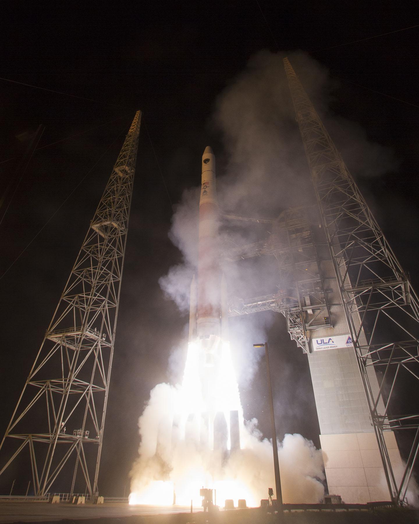
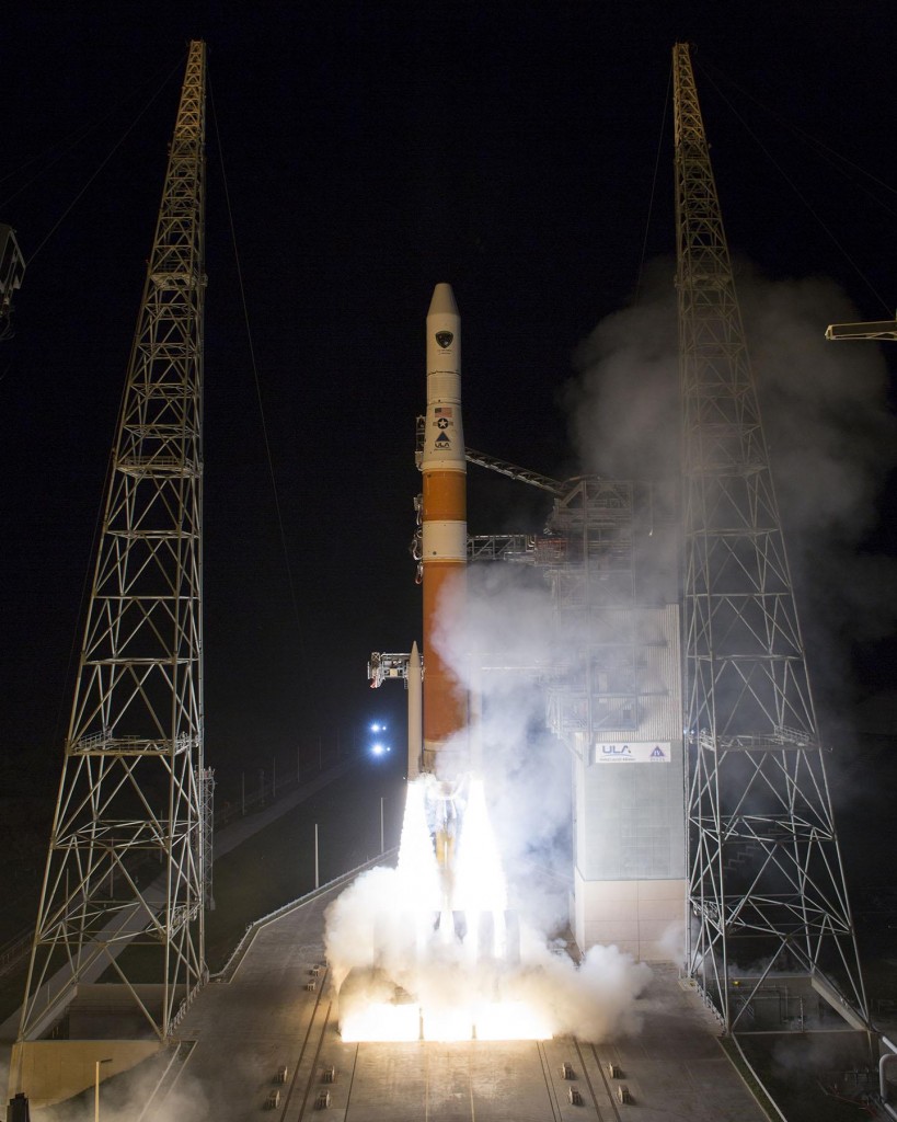
The U.S. Air Force’s ninth GPS Block IIF satellite (GPS IIF-9) launched on March 25 aboard a United Launch Alliance (ULA) Delta IV rocket, which has been the workhorse of the GPS fleet for successful launches. ULA provided this video showing highlights of the launch.
Tag: GPS Block IIF satellite
-
GNSS Constellations March On
This week nearly all the global navigation satellite systems will push their spatial presence one or two steps further, or higher, if they perform as scheduled. Rarely if ever has there been such a concentrated period of activity in the catapult category. Are we witnessing the real dawn of the multi-GNSS era? GPS, Galileo, BeiDou, and IRNSS all have positioned loaded rockets on the launching pad, destined to heave satnav payloads aloft. Only GLONASS seems stuck in stasis.
Leading the pack, as ever, GPS should send forth the ninth GPS Block IIF satellite (GPS IIF-9) on March 25 at 2:36 in the Eastern U.S. afternoon. Perhaps the event has already occurred by the time you read this.
The seventh and eighth Galileo satellites, Adam and Anastasia, are destined for a double date in space on March 27. After a four-hour flight into orbit 22,300 kilometers high, the duo will spring away from their Fregat fourth stage in opposite directions.
The launch of the fourth satellite for the Indian Regional Navigation Satellite System, scheduled for March 9 but postponed to replace a faulty onboard telemetry transmitter, will now take place on March 29. IRNSS-1D will pass the halfway point in India’s march to a seven-spacecraft regional constellation.
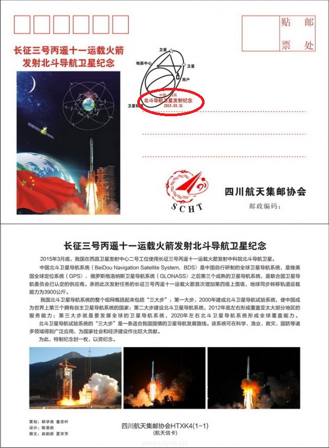
This philatelic first-day cover to commemorate an upcoming BeiDou launch indicates a specific date of March 31, 2015 (circled in red). Credit: BeiDou There are indications that the first satellite in the BeiDou Phase 3 expansion may be launched by the end of March. Apparently, a BeiDou satellite has been shipped to the Xichang launch site, and tracking ships have left port for the open ocean. Also, a postal stamp first-day cover for the launch — a common Chinese practice — has been issued with a March 2015 inscription. The launch will likely be that of a medium Earth orbit satellite.
A GLONASS-M single-satellite launch from Plesetsk had been expected in the first quarter of this year, but has not materialized. A GLONASS-M triple-satellite launch from Baikonur is expected in the April/May 2015 timeframe. The Russian constellation’s orbit count now stands at 26, fully sufficient for global coverage.
As the Ides of March in 44 B.C. mark a turning point in Roman history, the transition from Republic to Empire, so might this week mark complete world domination. GPS is now ¾ down the last section of road that leads to the fully modernized Block III generation. Galileo will reach, numerically, 1/3 of the total number of satellites it needs for full operational capability, although there is some doubt about whether all satellites now in orbit can be counted as full integers. BeiDou will mark its 15th operational satellite, out of a planned total of 35, with the new philatelically commemorated rising. And, as mentioned, IRNSS will pass its halfway point this weekend.
Ironically, just as GNSS begins to show signs of approaching its apogee (similar to the dawning of Empire in the Augustan Era that followed Caesar’s assassination on the Ides of March), the world is starting to turn away from, or turn beyond, GNSS.
GNSS will remain at the core of our navigation and positioning technologies — as Roman values remain at the core of Western civilization. But we need to go now to multi-sensor approaches for several reasons:
- some requisite positioning data, such as precise attitude, is not optimally derived solely from GNSS measurements;
- despite their increasing numbers, GNSS satellites will never be ubiquitous enough to be visible in sufficient numbers everywhere;
- threats such as jamming and interference will likely surmount all efforts at single-solution resilience to overcome GNSS vulnerability.
‘Twas ever thus. With rise come decline, with ripeness, decay. Sic transit Gloria.
-
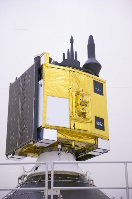
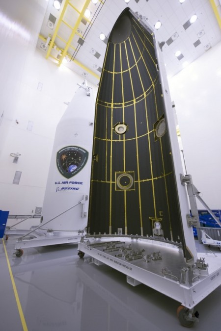
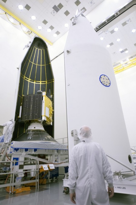
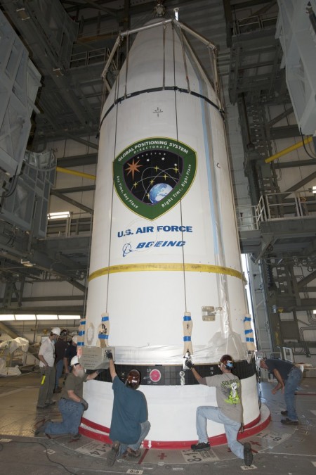
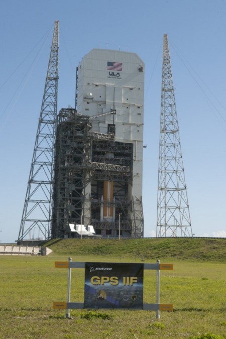
GPS IIF-9 Prepped for March 25 Launch
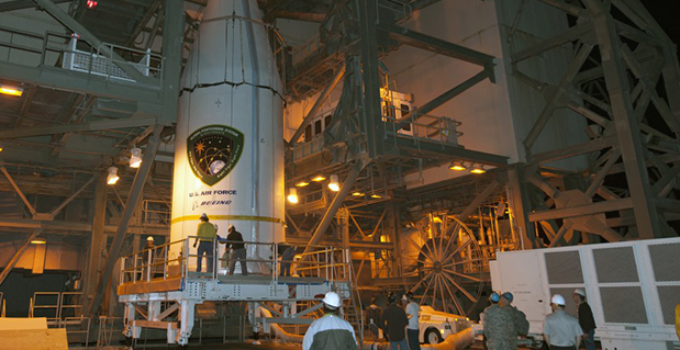
The U.S. Air Force’s ninth GPS Block IIF satellite (GPS IIF-9) has been encapsulated in the Delta IV rocket’s four-meter-diameter nose cone at a processing facility, and moved to the launch pad at Space Launch Complex 37 for mating to its booster inside the mobile service tower.
Launch is scheduled for March 25 at 2:36 p.m. EDT (1836 GMT) from Space Launch Complex 37 at Cape Canaveral Air Force Station, Fla. GPS IIF-9 marks the 29th Delta IV launch and the 57th operational GPS satellite to launch on a ULA or heritage launch vehicle.
To follow the launch countdown, dial the ULA launch hotline at 1-877-852-4321 or join the conversation on Facebook, Twitter or Instagram.
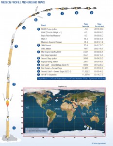
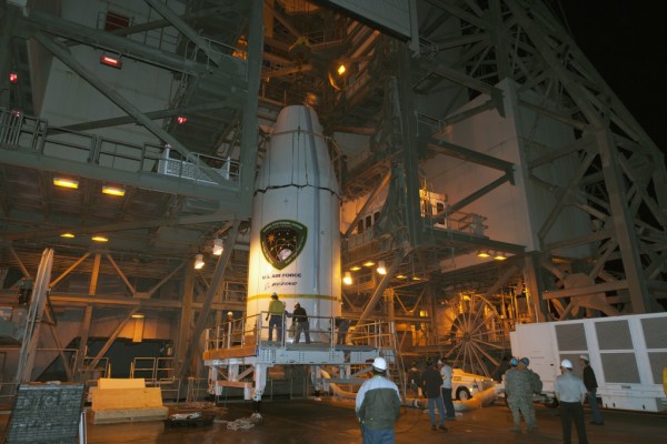
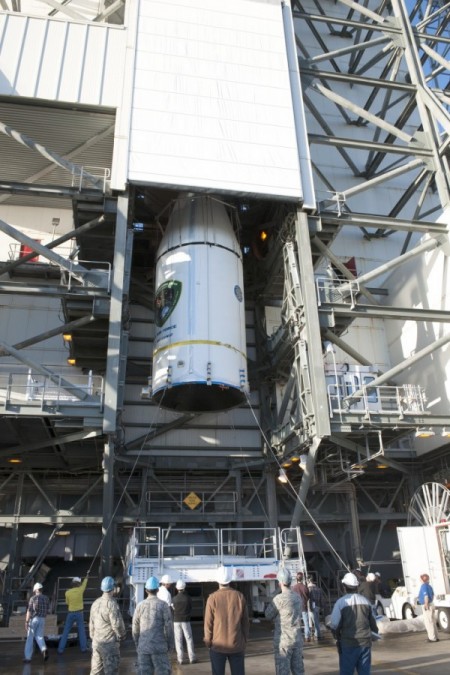
The planned GPS IIF-9 launch trajectory, event times, and ground trace. (courtesy of ULA) Below are photos from the United Launch Alliance, which supplies the Delta IV rocket and serves as the launch provider for the GPS Directorate.

courtesy of ULA 
courtesy of ULA 
courtesy of ULA 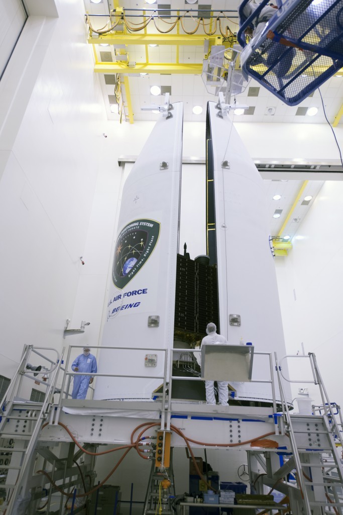
courtesy of ULA 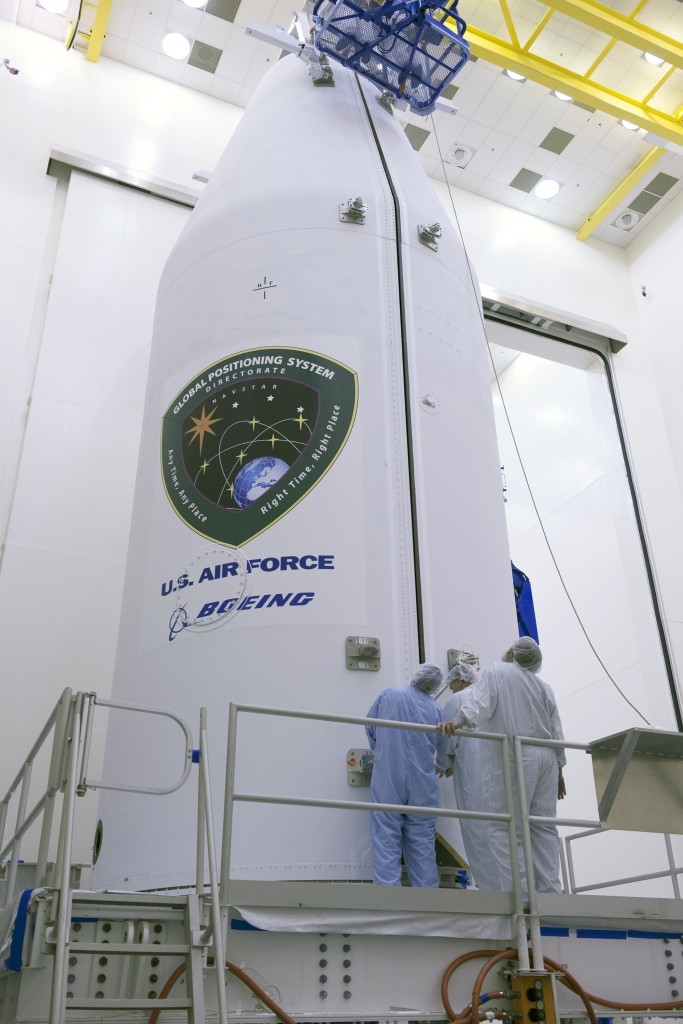
courtesy of ULA 
courtesy of ULA 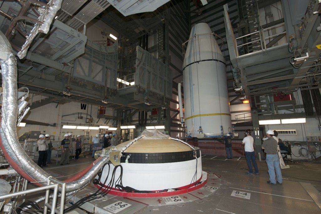
courtesy of ULA 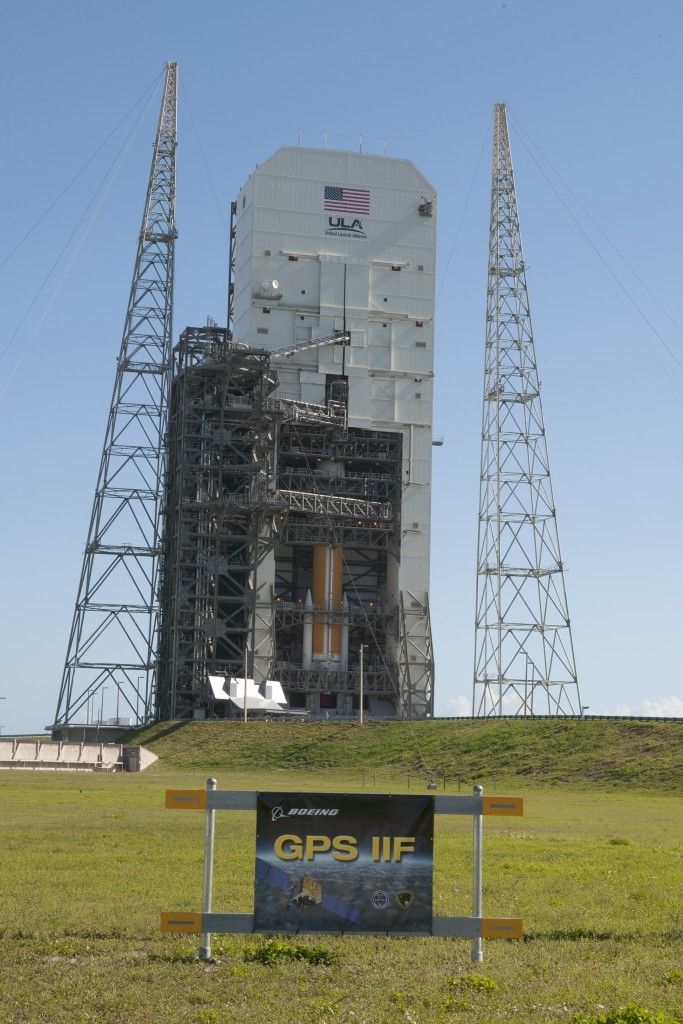
courtesy of ULA 
courtesy of ULA 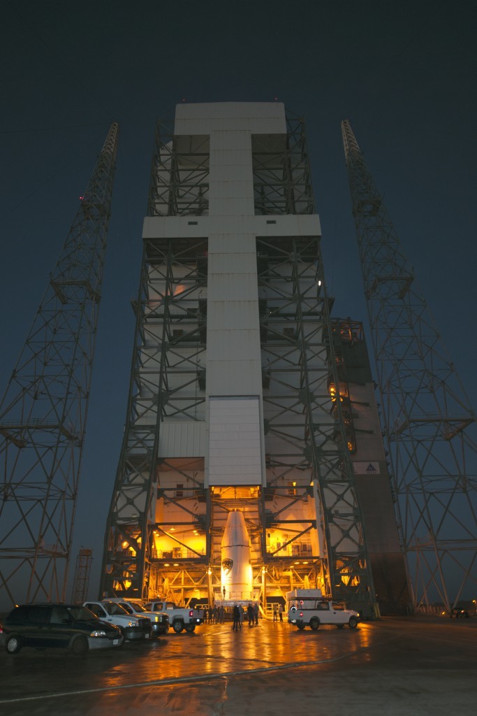
courtesy of ULA 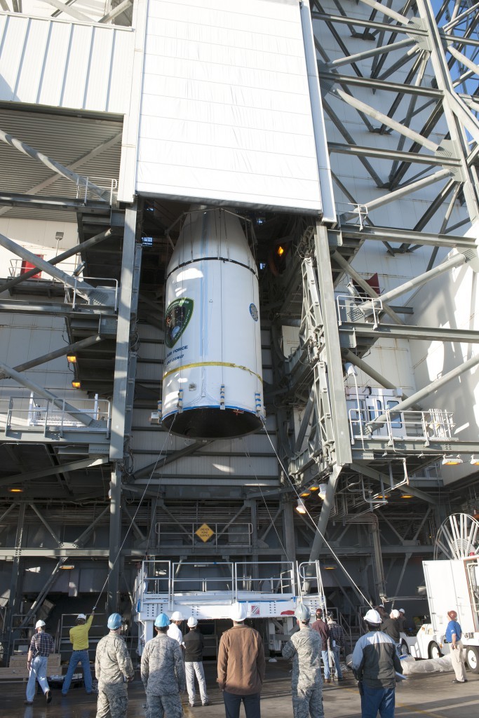
courtesy of ULA -
Delta Rocket Moves to Launchpad for March GPS Launch
The Delta 4 rocket that will launch the next GPS satellite has been rolled out to the launch pad, reports Spaceflight Now. The satellite itself, GPS IIF-9, will be attached to the rocket in March. The United Launch Alliance vehicle is scheduled for launch March 25.
The launch will be the 371st Delta rocket since 1960 and the 29th Delta 4 since 2002. It also marks the 69th GPS satellite launch and the 55th to use a Delta rocket.
-

The System: eLoran Operational on Eastern UK Coast
Bridge of the Galatea, a GLA vessel that carries a eLoran receiver and conducted tests of the new system. Photo: GLA Back-up to Vulnerable GPS Signals Required for Busy Shipping Lanes
The General Lighthouse Authorities (GLAs) of the UK and Ireland announced October 31 the initial operational capability of UK maritime eLoran. Seven differential reference stations now provide additional position, navigation, and timing (PNT) information via low-frequency pulses to ships fitted with eLoran receivers. The service will help ensure they can navigate safely in the event of GPS failure in one of the busiest shipping regions in the world, with expected annual traffic of 200,000 vessels by 2020.
Ships carry 95 percent of UK trade, accounting for its strongly expressed concerns regarding GPS vulnerability to jamming and spoofing, and the leadership role it has taken in eLoran research and testing. The UK is the first country in the world to deploy the technology along its coastline, thronged with both passenger and cargo services. Deployment involved replacing the existing radio receiver equipment in two prototype reference stations at Dover and Harwich, and the creation of five new reference stations in the Thames, Humber, Middlesbrough, and Firth of Forth and Aberdeen in Scotland, on the North Sea where oil-laden vessels come from deep-sea drilling rigs.
Entirely independent of GPS, eLoran can provide navigation information for vessels as well as the timing data necessary to maintain the power grid, cell phones, financial networks, and the Internet in the event of an outage. Unlike space-based navigation, eLoran signals can also reach inside buildings, underground, and underwater.
Captain Ian McNaught, deputy master of Trinity House, commented, “eLoran provides a signal around 1 million times more powerful than those from satellite signals, providing resilience from interference and attack. The achievement of initial operational capability for the system at Dover and along the east coast of the UK is a significant milestone, providing for improved safety aboard appropriately equipped vessels. The maritime industry would now benefit from the installation of eLoran receivers on more vessels to take advantage of improved navigational safety.”
“Telecoms, finance, energy, and other industries, which are subject to significant issues caused by the loss of timing signal provided by GPS, are recommended to take advantage of the enhanced reliability now available to address the over-dependence of key national infrastructure on vulnerable satellite systems,” McNaught said.
eLoran technology is based on longwave radio signals and is independent and complementary to GPS.
Several other nations are consulting with the UK GLAs on eLoran. South Korea wants to establish an eLoran alliance with the UK while it pursues its own rollout of differential eLoran reference stations and new eLoran transmitters based on the latest technology. In 2012, South Korea was the victim of a 16-day GPS jamming attack by North Korea.
Full operational capability covering all major UK ports is expected by 2019.
Galileo Roving High
The fifth Galileo navigation satellite, one of two left in the wrong orbit in August, made a series of November maneuvers as a prelude to its health being confirmed. The aim was to raise the lowest point of its orbit — its perigee — to reduce the radiation exposure from the Van Allen radiation belts surrounding Earth, as well as to put it into a more useful orbit for navigation purposes.
Should the two-week operation prove successful, the sixth Galileo satellite will follow the same route, according to the European Space Agency (ESA).
The Galileo pair, launched together on a Soyuz rocket on August 22, ended up in an elongated orbit traveling out to 25,900 kilometers (km) above Earth and back down to 13,713 km. The target orbit was a purely circular one at an altitude of 23,222 km. Also, the orbits are angled relative to the Equator less than originally planned.
The two satellites have only enough fuel to lift their altitude by about 4,000 km — insufficient to correct their orbits entirely. But the move will take the fifth satellite into a more circular orbit than before, with a higher perigee of 17,339 km.
“The new orbit will fly over the same location every 20 days,” said Daniel Navarro-Reyes, ESA Galileo mission analyst. “The standard Galileo repeat pattern is every 10 days, so achieving this will synchronize the ground track with the rest of the Galileo satellites.”
“In addition, from a user receiver point of view, the revised orbit will reduce the variation in signal levels, reduce the Doppler shift of the signal, and increase the satellite’s visibility,” Navarro-Reyes said. “For the satellite, reducing its radiation exposure in the Van Allen radiation belts will protect it from further exposure to charged particles. The orbit will also allow Galileo’s Earth Sensor to hold a stable direction for the satellite’s main antenna to point at Earth. Right now, when the satellite dips to its lowest point, Earth appears so large that the sensor is unusable. The satellite relies on gyroscopes alone, degrading its attitude precision.”
The recovery is being overseen from the Galileo Control Centre in Oberpfaffenhofen, Germany, with the assistance of ESA’s Space Operations Centre, ESOC, in Darmstadt, Germany. France’s CNES space agency is providing additional ground stations so that contact can be maintained with the satellite as needed, ESA said.
Welcome IIF-8
The U.S. Air Force launched the eighth GPS IIF satellite on October 29, aboard an Atlas V 401 rocket. With this new arrival on orbit, only four more Block IIF satellites remain to be placed aloft. Three are in storage awaiting launch, and one is in production.
The Boeing-built GPS IIF-8 (SVN-69/PRN-03) will replace SVN-51 in the E plane slot 1. SVN-51 will be re-phased from E1 to an auxiliary node at E7 somewhere around SVN-54 currently on station at E4, according to the Air Force Second Space Operations Squadron (2 SOPS). SVN-38/PRN-08 will be taken out of the operational constellation prior to SVN-69 payload initialization and sent to Launch, Anomaly Resolution and Disposal Operations (LADO). PRN-08 will be assigned initially to SVN-49 and set to test.
SVN-51 will remain in an auxiliary node once it completes its re-phase journey. The SVN-51 re-phase will take about six months after the initial burn occurs.
-

Delay in Setting Recently Launched Block IIF Satellite Healthy

A United Launch Alliance Delta IV lifts off from Space Launch Complex-37 with the Air Force’s Global Positioning System (GPS) IIF-5 satellite. This launch marked the 25th Delta IV flight since the first flight in 2002. The latest GPS Block IIF satellite, IIF-5 or SVN64 (operating as PRN30), was launched on February 21, 2014. Typically, GPS satellites are checked out and made operational within about a month following launch. SVN64 has yet to be set healthy.
The delay is due to an extended navigation test being performed by the GPS master control station. A navigation upload for SVN64 was performed in March with ephemeris and clock data as usual streching weeks in advance. However, unlike with operational satellites, no further updated uploads have been performed. The aging ephermis and clock data gradually becomes less and less accurate as time goes by but should degrade gracefully.
Inquisitive observers will have noticed that the received navigation data from SNV64 changes infrequently. Currently, the navigation data changes once per day with an epoch of 13:00 GPS Time unlike every two hours with operational satellites. And the data fit interval is 26 hours, compared to four hours.
The test is scheduled to run until mid-May.
-
New GPS IIF Satellite Launched
A United Launch Alliance Delta IV lifts off from Space Launch Complex-37 with the Air Force’s Global Positioning System (GPS) IIF-5 satellite. This launch marked the 25th Delta IV flight since the first flight in 2002. Credit: Ben Cooper/ULA News compiled with the assistance of CANSPACE listserv.
After a brief delay due to concerns over solar radiation trends, the GPS IIF-5 satellite was successfully launched at the end of the designated launch window at 01:59 UTC on February 21. The satellite, attached to the launch rocket’s upper stage, was initially placed in a highly elliptical orbit. Following a third burn of the rocket, the satellite was released into its assigned orbit at about 05:37 UTC today.
Here is a video showing highlights of the launch:
GPS IIF-5 will replace the aging spacecraft known as GPS IIA-28 in Plane A, Slot 3 of the constellation.The GPS IIA-28 satellite was launched aboard Delta 249 on November 5, 1997, as the final member of the Block IIA series. It will go into a reserve role in the network for the remainder of its useful life.
This is the first of three GPS launches planned through July to replace aging craft in the constellation. GPS IIF-5 incrementally upgrades the constellation with improved accuracy, enhanced internal atomic clocks, better anti-jam resistance, a civil signal for commercial aviation, and a longer design life, all features of the Boeing-build Block IIF series. This will be the fifth of 12 Block IIF spacecraft being built to form the backbone of the GPS fleet for the next 15 years.

Launch logo. The nickname of the IIF-5 satellite is Canopus, the brightest star in the modern constellation Carina and the second brightest star in the night-time sky, after Sirius. According to the Air Force, the new capabilities of the IIF satellites will provide greater navigational accuracy through improvements in atomic clock technology, a more robust signal for commercial aviation and safety-of-life applications, known as the new third civil signal (L5), a second civil signal (L2C) available for the dual-frequency GPS receivers and a 12-year design life providing long-term service. These upgrades improve anti-jam capabilities for the warfighter and improve security for military and civil users around the world.
“I am pleased with the outcome of today’s launch. The new capabilities provided by the IIF satellites will improve operations, sustainment and overall GPS service for the warfighter, international, commercial and civil communities,” said Col. Bill Cooley, director of the Space and Missile Systems Center’s Global Positioning Systems Directorate.
“The modernized capabilities that are coming on board with the successful launch of GPS IIF-5 will support the worldwide GPS community for years to come. I would like to recognize the outstanding commitment and the superb dedication to mission success from the 45th and 50th Space Wings, our industry partners: Boeing and United Launch Alliance, and the GPS IIF and Delta IV program teams at the Space and Missile Systems Center,” said he said.
The GPS Block IIF satellites are built by Boeing, and are operated by the United States Air Force following their launch by United Launch Alliance, using Evolved Expendable Launch Vehicles.
- The first GPS IIF satellite was launched on May 27, 2010, and entered service on Aug. 26, 2010.
- The second satellite, which launched on July 16, 2011, entered service on Aug. 22, 2011.
- The third satellite launched on Oct. 4, 2012, and entered service 22 days later.
- The fourth IIF was launched May 15, 2013, and entered service on June 21, 2013.
Every modern GPS satellite was launched from Cape Canaveral Air Force Station.
Each GPS IIF satellite delivers:
- Greater navigational accuracy through improvements in atomic clock technology,
- A new civilian L5 signal to aid commercial aviation and search and rescue operations,
- Improved military signal and variable power for better resistance to jamming in hostile environments,
- A 12-year design life providing long-term service and reduced operating costs,
- An on-orbit, reprogrammable processor that can receive software uploads for improved system operation.
“Once again, a group of talented mission partners rose to the challenge of launching another successful mission from the Cape,” said Col. Douglas Schiess, commander, 45th Operations Group, who served as the Launch Decision Authority. “Those mission partners include the 45th Space Wing, the Space and Missile Systems Center, the 50th Space Wing, United Launch Alliance, Boeing, and our other industry partners with the Delta IV and GPS IIF launch teams.”

A United Launch Alliance Delta IV lifts off from Space Launch Complex-37 with the Air Force’s Global Positioning System (GPS) IIF-5 satellite. This launch marked the 25th Delta IV flight since the first flight in 2002. A United Launch Alliance Delta IV lifts off from Space Launch Complex-37 with the Air Force’s Global Positioning System (GPS) IIF-5 satellite. This launch marked the 25th Delta IV flight since the first flight in 2002. -
GPS IIF-5 Launch Delayed
The scheduled October 23 launch of GPS IIF-5, the fifth in the current “follow-on” generation of GPS satellites, has been postponed in order to complete a review of an adjustment made to the rocket’s upper stage engine. A fuel leak in that engine of the Delta 4 rocket during a GPS launch in October of last year created some worries for the Air Force and the United Launch Alliance (ULA), although the satellite successfully reached its intended orbit despite the upper stage producing less thrust than expected.
A subsequent investigation determined a fuel leak in the engine system was responsible. Two medium Delta IV rockets and one heavy version have launched since then, but ULA said continued investigation had produced new information about the engine’s first start.
While no new definitive launch date has been set, the ULA released a statement:
“The ongoing Phase II investigation has included extremely detailed characterization and reconstructions of the instrumentation signatures obtained from the October 2012 launch and these have recently resulted in some updated conclusions related to dynamic responses that occurred on the engine system during the first engine start event.
“The GPS IIF-5 Delta IV launch is being delayed to allow the technical team time to further assess these updated conclusions and assess the improvements already implemented and determine whether additional changes are required prior to the next Delta IV launch.
“The Delta IV booster for the GPS IIF-5 mission has completed the standard processing and checkout on the launch pad and will be maintained in a ready state for spacecraft mate and launch pending completion of this assessment. A new launch date will be established when the assessment of the updated dynamic response information is completed in the coming weeks.”
.
-
Col. Bernard Gruber, GPS Directorate: Farewell Perspective on GPS Program

Colonel Bernard Gruber. I first met just-pinned-on, shiny and bright, Captain Bernard Gruber-USAF in 1992. Bernie had just arrived at the Space and Missile Systems Center at Los Angeles Air Force Base in California where he would hold several important positions.
For those readers not aware of the mission and importance of the Space and Missile Systems Center (SMC), today SMC, which began in 1954, is the nation’s center of technical expertise for military space acquisition with more than 5,000 employees nationwide and an annual budget of $10 billion.
Bernie’s first association with GPS at SMC was as the chief of User Equipment Production at the then NAVSTAR Global Positioning System Joint Program Office (GPS-JPO). He went on to serve as the program manager for Foreign Military Sales (FMS), working with our allies, and then as the program manager for Advanced Military Devices, which is a euphemism for things we can’t discuss in this venue. All this in a short 40-month time frame, which is almost as long as he has served in his current capacity as the director of the Global Positioning Systems Directorate, now 21 years later. As a young starry-eyed captain, I remember Bernie as energetic, dedicated and full of ideas, which pretty much describes him today as he completes his last active duty assignment and his 26-year U.S. Air Force career draws to a close.
While it may be fair to say that Bernie had some notion of what to expect when he was assigned as the commander of the GPS Wing in 2010, he actually had no idea of all the tremendous and mostly positive changes that would occur to the GPS program under his watch.
I thought it would be fitting to conduct an exit interview with Bernie during his last full month on the job and get his opinion concerning the changes to GPS during his tenure and the probable way ahead for GPS as he turns over the reins.
Don Jewell (DJ): Colonel Gruber, thanks for taking the time to speak with us today. I know you are extremely busy and your time is running short at SMC. Bernie, you have certainly lived the old Chinese adage, also sometimes described as a curse, during your tenure as the GPS Wing Commander and as the director of the GPS Directorate, “May you live in interesting times.” Your tenure has been beset with one major challenge after another and yet you have persevered and — I think this is something for which you will be remembered — you have consistently turned those challenges into opportunities. Let’s discuss some of the opportunities.
 Certainly sequestration and budget issues are big topics today. Having come from the Pentagon and having worked on the financial side of GPS, were you surprised by what you found when you took over as the GPS Wing commander? Was it all you expected it to be? The big question seems to be, how is sequestration going to affect the future of the GPS?
Colonel (USAF) Bernard Gruber (BG): Well, Don, certainly budget issues are a key topic today, but let me say before we get started on the questions and answers that I really appreciate the opportunity to speak with you and your readers at GPS World. As you said in your introduction, these have certainly been interesting times. Some people may call it crazy but they are certainly interesting, nonetheless.
I must say that I was pleasantly surprised how much had changed on the [GPS] program when I came back to SMC, and the changes were really all for the good. It warmed my heart to see the Foreign Military Sales [FMS] office — which I actually started back in 1992 — now has agreements with 55 nations, and military sales continue to increase year-by-year. I was also very happy and surprised to see the SAASM or Selective Availability and Anti-Spoofing Module program, which I was actually the program manager for in its infancy, has now been installed on over one million GPS military receivers — in my estimation this program is protecting warfighters around the globe every single day. I think that is something we can be very proud of together.
The folks in the [GPS] Program Directorate that I have had the good fortune to work with are really something special. They work their hearts out every single day to protect, modernize, and sustain this great system. Also, I continue to be very much amazed that people understand the value of GPS as part of our critical infrastructure. So, my thanks to folks like you, Don, and the folks at GPS World for educating the public on this great utility that we have.
DJ: Thank you, Bernie, for those kind words. You know we are always happy to serve.
BG: Moving on to the sequestration bill… We are working very hard to reduce our costs and invest in different opportunities that have a return on investment like dual launch [of GPS III — ed.] and NavSat, or I think it is NibbleSat, as you and Dr. Parkinson referred to it in your article from the National Space Symposium, which we look at as an augmentation to GPS III. That is a good thing because it can significantly reduce total lifecycle costs of the program. So we continue to look at these, amongst other items, that we will prioritize and spend our development dollars on — items such as Lithium Ion (Li-Ion) batteries, smart solar arrays, that allow you to have more efficient use of power, more efficient power amplifiers, that are significantly shrunk down in size from what we have today. Bottom line is we will continue to work on processes that clearly show a positive value stream.
DJ: I would think that one of your bigger, albeit not technical, challenges during your tenure was transitioning the GPS Wing back to an SMC Directorate. Any thoughts about the wisdom of that transition? Has it affected operations in a positive or negative way, or can you detect a difference? Has it affected the space career field for your military members?
BG: I remember you asking me this very same question back in 2011 during our very first interview, and I wish I remembered [ed. We remember — click the link] what I said back then, but I will give it a shot from where we are, right here, right now (laughs).
General Sheridan, as you very well know, the prior SMC Commander, had actually given me six goals when I got here. The first of those was fix the gap between OCX and GPS III. If you recall, we had about a 15-month gap in the delivery of those items. The second one was he asked me to transfer the AEP and LADO [launch, early orbit, anomaly and disposal operations, now provided by Braxton Technologies] ground segment to our users [the 50th Space Wing] and get that capability to them as soon as we could, so that they could operate it and own it. The third one was fix the IIF production line. The fourth one was to get the MGUE, or military GPS user equipment, back on track and award contracts. The fifth one was build a relationship and continue that relationship with the 50th Space Wing [Schriever AFB, Colorado]. The last one that he actually gave me was to ready the first space vehicle for GPS III through the GNST, which of course is the GPS III Non-Flight Satellite Test Bed and an engineering, manufacturing and development pathfinder for the GPS III program, used to achieve modernization. And, Don, I am happy to say that we as a team have achieved every one of those goals.
Not far behind those goals, Don, General Sheridan followed up with the task of transitioning the Wing back to the Directorate. And as far as I can tell, it has really been seamless. I have to say, though, I really miss the instant recognition that we, as airmen first and then as acquisition professionals, had when we were called Squadrons, Groups and Wings. While I certainly understand that the number of folks that we supervise may have not have justified those titles by themselves, the level of responsibility that we have and my peers have around here certainly did, in my opinion. All around the change has not affected us in any negative way, and I really don’t detect any significant difference resulting from that transition.
DJ: Bernie, you oversaw the first successful launches of the Boeing-built GPS IIF satellites — a program beset by significant schedule and costs issues. Yet it has evidently become a success under your watch, even though there are still some issues. What are your overall thoughts about the IIF program?
BG: Thank you for that, but I really share this success with many, many other people here at SMC as well as at Team Boeing. The IIF program really and truly has turned a corner. It’s delivering world-class position, navigation and timing (PNT) data right now for users all over the world. Under my watch we had the addition of three IIF satellites actually put into the active constellation today. And although a lot of people may not know it right now, we recently achieved our very best day ever on the 21st of April in terms of accuracy of the GPS signal, with average user range errors (URE) of less than 51 centimeters. That is really astounding! It is better, clearly better, than any PNT system in the entire world today.
So the IIF program, at this point, is focused on closing out the production line and certainly completing those remaining few satellites. We will ready those eight satellites for launch, and then we will support the existing on-constellation needs as they arise.
Now, the nature of space programs is such that technology issues can, of course, creep up on you at any given time. I think we have proven that we can meet those issues head-on and keep the program on track. I could not be prouder of my IIF team very specifically. I very much recall when I first walked into this program office, when we had to actually shut down the IIF production line for over a month. That was a hard thing to do, but it really focused us on closing all the discrepancy reports we had and modeling a very smooth production flow.
So, here we are now with four [GPS-IIFs] on orbit, and five in the barn. As far as I can tell, programmatic and technology challenges have really pretty much been abated to continue to allow world-class spacecraft and mission data as we look forward.
And, Don, let me also add that we successfully transitioned at that time the entire ground segment, the LADO system, which I know you are very familiar with, the systems training system, as well as the data archival system to our operators and partners at the 50th Space Wing, without one single lien.
DJ: Bernie, what you just told us is very impressive. Accuracy and standardization are critical to GPS program success, and it sounds like you have that well in hand. Of course, the seamless transition of key responsibilities to the 50th Space Wing and 2SOPS (2nd Space Operations Squadron) is to be applauded. Plus, it really appears you have the IIF issues resolved and the GPS III program has become a reality during your tenure. What are your hopes for that program? Do you think the Lockheed Martin built GPS III will truly, as some have predicted, become the first 30-year GPS satellite?
BG: The bottom line is that I sincerely hope that the GPS III program will be a benchmark for future space acquisition programs, both in terms of the high standards that were set for mission assurance, and the level of communication between our program office and the contractor. The GPS III program is entering the very early stages of testing right now on the first flight vehicle, and I anticipate that we will begin to see the program move down that learning curve in very short order. You know with the 15-year design life, which we put in the contract, along with stringent parts requirements and our priority on systems engineering, I really do expect that the GPS III satellites will operate beyond the standards set by the current constellation. And I do have to say that what we call our “back to basics” approach, that other folks have written about, which includes those attributes of strong systems engineering discipline, detailed manufacturing systems readiness reviews, and strict adherence to standards, are actually now showing tangible and documented results. In some cases a 60-percent reduction in our cycle time and a 70-percent reduction in discrepancies for the next delivered items. I think that is huge.
You know, even from an historical perspective, our pathfinder vehicle, which we talked about earlier, called GNST, has taken actually one year out of labor and interference testing from troubleshooting we have seen on two previous programs alone. So we are taking GNST through all the steps the very first GPS III satellite will be exposed to. Then we will ship it down to the Cape [Canaveral] in one month and we should be able to complete our initial and final look at integration and delivery.
DJ: Bernie, so far we have talked mainly about the successes in the space segment, while the future of OCX to many still seems very uncertain, especially in light of the latest GAO report, which had some serious issues of its own. You have been closer to this process than anyone. What are your thoughts? Does OCX have a future? There are rumors there are going to be major changes. Any announcements you would like to make or predict?
BG: The development program for the Next Generation Operational Control System has made significant progress, and has just recently completed a very critical Milestone B approval, in November 2012. As we stand right now, the program is poised to deliver the next-generation GPS space vehicle command and control capability, mainly for GPS III, of course. It will replace our legacy ground [command and control] system and will support legacy and future space vehicles, as well as all the signals that accompany them. The program at this point remains on track to deliver capabilities according to the acquisition program baseline that we set down during the recent milestone.
That said, Don, some of the recent and heavy work of information assurance criteria are extremely rigorous. In fact, they are the most rigorous I have ever seen on any program that I have been involved with. Someone once told me a few months ago, “Bernie, you know you are building an information fortress that just happens to do Command & Control.” So I don’t know if I actually subscribe to that thought, but I think it gets the point across. In today’s cyber-threat environment, we have to do this, and we have to do it right for the protection of GPS.
To give you some confidence in the program, as of today we have actually coded over 98 percent of the Block Zero system, which is the basis for launching and commanding the basic GPS III constellation and, of course, the first vehicle. And we followed that up with two very significant exercises to provide telemetry and an integrated planning system. In July, we will actually go forth with our third exercise itself. In fact, I just got off the phone with the team a few minutes ago, to exercise what we call off-nominal behavior. Those are different types of test plans we have to go through just in case something in the system goes wrong.
What that means, Don, is if something does not go according to plan, what we do is we inject faults into the system and other types of non-nominal behavior, and then we see if we can do recovery actions and how the command and control system will actually fix it and correct it. This ensures the operators will have the tools to fix it.
So, Don, as kind of an overview, along with what we call the complete authority to test the documentation that is in place right now and the conclusion, which we recently had, of our third critical design review, I think we are on our way. We will be challenged along the way, there is no doubt about that, but we are looking forward to achieving our full capability with Block One. [ed. OCX Block RTO currently scheduled to be delivered in Q1 2017.]
DJ: Bernie, that is great news for those who are worried about the future and viability of OCX. It is good to know you still see a way ahead. Now we have covered the three main segments of the program, but there are still concerns over the initial acquisition process and how that plays out over time. Certainly in your career you have been steeped in Air Force and DoD acquisition programs for years, which is a process many in government describe as a process in need of a major overhaul. What are your thoughts? How could we, the government, the USAF, do things differently? Any solutions or cogent thoughts?
BG: Sure, off the record! No, seriously, I have indeed been involved in acquisitions for a long time now, and let me just say that is a great question and it is certainly deserving of a much, much longer answer than I have time to provide for you here today. As a matter of fact, I have written a couple of papers on the subject of acquisition reform in the past, and I have been involved with three very significant studies in Defense Acquisition University (DAU) as well as one of our nation’s premier think tanks, the Center for Strategic and International Studies in Washington, D.C.
But, in my opinion, there is a lot we can do, so let me just capture a couple of thoughts here. The first one, and I have noted this one many time before, is funding and requirements stability, both in what we call the program stages and execution stage of the program, is just paramount. That said, I fully realize with sequestration and budget control measures that we cannot control budget releases from Congress, cuts or changes. But it really does create an incredible burden on our ability to deliver systems on time. The second is one is to look seriously at decentralizing execution. As has been cited in many studies before, whether those be “Beyond Goldwater-Nichols” or the DAPA Study (Defense Acquisition Performance Assessment) that some people call the General Kadish study, it is easy for anyone along the long chain of acquisition approvals to say no or to add another layer of documentation or to change, but the ripple effect of doing that as well as what it does to the system is just overwhelming.
And I will say that as our Air Force Space Command commander (AFSPC/CC), someone who I know both you and I respect very deeply, General William Shelton, often says, “You know these times come with great opportunities and we need to seize upon them.” I couldn’t agree more with him.
DJ: Colonel Gruber, I assume you have had at least a few moments in your hectic schedule to reflect on your tenure at SMC and the GPS Directorate, so as we wind down today, can you describe your high and low points in the job? Would you in hindsight do anything differently?
BG: I think that is a great question, and I will say in all sincerity that there have actually been very few low points on this job, but there have been a couple. As you know, it has been frustrating for me to see civilian funding on GPS not come to closure. We have taken very large cuts over the last couple of years, and I am really not sure that the future is any more certain. I am not sure where we stand right now. This has a combined effect of increasing risk and potentially delaying the OCX program capabilities. Also, I was disappointed, quite frankly, to not be postured adequately to get a multi-year buy for the GPS III satellite system this time around for satellite vehicle nine and out. I truly believe that we can greatly reduce our costs through stable production line, an increased learning curve, correct incentives, and a large block buy. I really think we are going to get there, but I would really liked to have gotten this done before my successor, Colonel William “Bill” Cooley, arrives here in about a month.
As far as the high points go, Don, there are literally hundreds — seeing our folks get promoted, supporting the community activities here at Los Angeles Air Force Base, and of course the mission successes that we have enjoyed. These include, of course, the recent and successful launch of the IIF-SV4 on the 15th of May. Increasing the dependability of the GPS ground segment, and that is an actual measure, to 99.34 percent, which, by the way, is the best it has ever been in the history of the program. Awarding new contracts for on-orbit support and ground contracts that have reduced our contract costs by almost 50 percent. Another one is locking in three vendors to be able to build the next generation of GPS [ed. military] user equipment, and of course the achievements of the SMC commitments that I mentioned earlier and those that General Pawlikowski [SMC Commander] have laid out for us for the future.
So, in the big scheme of things, I am not sure that I would have done anything different, but the truth is, Don, it might take a little bit more reflection on my part, and I might answer that differently sometime in the future. But for right now I feel very confident with what we have done and very proud of what the team has taken forward with me.
DJ: Colonel Gruber I want to thank you very much for your time today, for your dedication to the GPS mission and for your service to your nation over the last 26 years. Now, this is your opportunity for a parting message and a chance to fill us in on what your future holds.
BG: I am not sure I have a parting message for you. Truth be told, leaving this program, the people in it and the great service our country provides through GPS is going to be hard to do. My three years is up, and I will be retiring from the USAF after 26 years of service. It has been a great ride. I applaud the efforts of you and your readers, our contractors, our government employees, and our international partners, of course, who continue to overcome adversity and invent new applications and services for GPS. But most of all, Don, I really want to thank the men and women who serve in deployed regions of the world. They are putting their lives on the line every single day. We owe it to them to have this system to be able to support them, anytime and anyplace.
And as to my future — I actually leave the Air Force with a smile on my face, it has been a great ride. After many discussions with my family, we are heading back to our roots in Minnesota. My wife and I are very fortunate to be able to make the decision to spend time with our parents and our families and relatives back home in the St. Paul-Minneapolis area.
DJ: Well, Bernie, I am totally surprised. I don’t think I ever heard you say, “ja shure, you bet, you know” once in all the years I have known you.
BG: Ya know, Don, I can really lay it on pretty thick when you need me to, ya know. [ed. Saying this, Bernie sounds exactly like an extra in the movie Fargo.] But seriously, we are going to spend some time with family and take it easy for awhile, and then I will explore future opportunities.
And with that comment, we wish Colonel Gruber the best of luck in the future. That’s a wrap for this month. Next month we will review some of the latest and best user equipment for our warfighters, government users, and critical first responders. So until next time, happy navigating.
-
Boeing Completes 5th GPS IIF Satellite for U.S. Air Force

GPS IIF pulse line Boeing is building 12 Air Force GPS IIF satellites on its innovative pulse line at the Satellite Development Center in El Segundo, CA. The pulse line enables simultaneous construction of multiple satellites, increasing savings, quality and efficiency. Photo credit: The Boeing CompanyThe Boeing Company has completed the fifth of 12 Global Positioning System (GPS) IIF satellites the company is building for the U.S. Air Force. The spacecraft was built at the Satellite Development Center in El Segundo using the GPS IIF pulse-line manufacturing approach, which draws on commercial production line practices to build satellites faster and more efficiently.
Of the five completed GPS IIF satellites, two are on orbit as part of the current 31-satellite constellation; both satellites are meeting mission requirements. Three satellites are in storage on standby for launch by the Air Force. The remaining seven are in various stages of pulse-line production and will likely be added to the constellation over the next three to five years as determined by the Air Force to ensure robust constellation availability.
"Boeing, in close partnership with the U.S. Air Force, is focused on execution and mission assurance — we are committed to sustaining the GPS constellation with GPS IIF," said Craig Cooning, Boeing vice president and general manager of Space & Intelligence Systems. "The GPS IIF spacecraft feature more capability and improved mission performance for the warfighters and civilians who depend on this critical system."
The next GPS IIF launch is scheduled for the fourth quarter of 2012. The satellite will be launched aboard a United Launch Alliance Delta IV vehicle from Cape Canaveral Air Force Station, Florida.
GPS is a space-based, worldwide navigation system providing users with highly accurate, three-dimensional position, velocity and timing information 24 hours a day in all weather conditions. GPS IIF satellites provide enhanced capabilities, including a jam-resistant military signal, greater accuracy through improved atomic clock technology, and a protected, civilian L5 signal to aid commercial aviation and safety-of-life applications. Boeing also is the prime contractor for the GPS Operational Control Segment, which has supported an expanding set of GPS services and capabilities since 2007.
-
The System: Galileo IOV Satellites Now in Orbit

The first two satellites for Europe’s Galileo global navigation satellite system were lofted into orbit October 21 by the first Russian Soyuz vehicle ever launched from Europe’s Spaceport in French Guiana in a milestone mission, reports the European Space Agency (ESA).
The launch occurred one day after initially scheduled to resolve a problem with the ground-support fueling system.
The Soyuz VS01 flight, operated by Arianespace, started with liftoff from the new launch complex in French Guiana at 10:30 UTC on October 21. All of the Soyuz stages performed as expected and the Fregat-MT upper stage released the Galileo satellites into their target orbit at 23,222 kilometers altitude, 3 hours 49 minutes after liftoff.
The two Galileo satellites are part of the In-Orbit Validation (IOV) phase that will see the Galileo system’s space, ground, and user segments extensively tested. During initial operations, the satellites will be controlled by a joint ESA and CNES French space agency team in Toulouse, France. Once that week-long phase ends, the satellites will be handed over to the Ober-pfaffenhofen Galileo Control Centre near Munich, operated by the DLR German Aerospace Center, which will be responsible for routine operations. Operating the satellite payloads to provide navigation services will be the task of the Fucino Control Centre, near Rome, operated by Telespazio.
The next two Galileo satellites, completing the IOV quartet, are scheduled for launch in summer 2012. Together, alll four are intended to prove the design of the Galileo system in advance of the other 26 satellites.
These first four satellites, built by a consortium led by EADS Astrium Germany, will form the operational nucleus of the full Galileo satnav constellation. According to ESA, the satellites combine the best atomic clock ever flown for navigation — accurate to one second in three million years — with a powerful transmitter to broadcast precise navigation data worldwide.

Artist’s depiction of a Galileo satellites being ejected from the dispenser.Second IIF Good Now
The second GPS Block IIF satellite, SVN63/PRN01, launched in mid-July, was finally set healthy on October 14. The delay in bringing the satellite into service was due, in part, to extended testing of the cesium atomic frequency standard (AFS) on the satellite.
GPS IIF satellites carry three AFSs: one cesium and two rubidiums. The performance of the cesium AFS, independently confirmed, was poor. A switch to one of the rubidium AFSs took place on October 5.U.S. Agencies Speak Out on LightSquared; Others Hide Their Cards
The U.S. House of Representatives Committee on Science, Space, and Technology has released some of the impact statements provided by federal agencies to the National Telecommunications and Information Administration (NTIA). The reports reveal deep concerns about and opposition to the LightSquared proposal, and detail cost estimates and other adverse impacts to government-wide operations should it go forward.
The NTIA itself has refused to make these agency reports public, rebuffing a Freedom of Information Act (FOIA) request by GPS World magazine and, so far, giving the same response to congressional committees on both the House and Senate side.
Missing in Action. The House Committee does not yet have access to all the agency statements; still missing are those from:
- the Department of Homeland Security,
- the Department of Commerce,
- the National Oceanic and Atmospheric Administration,
- the National Institutes of Standards and Technology.
The House committee has written to those departments asking for their reports; GPS World has also filed further FOIA requests specifically with those agencies. The Department of Defense impact statement is presumed to be classified.
Seventy-Two Billion. The Federal Aviation Administration (FAA) impact statement is the strongest statement of those provided so far to the House committee. It asserts, among many other findings, that the LightSquared proposal would cost the aviation community at least $72 billion, preclude elimination/reduction of an estimated 794 air-traffic fatalities over the next 10 years, set back planned air-traffic safety and efficiency measures by that same period, affect U.S. leadership in aviation, and damage the international market for U.S. satellite technology.
“FAA cannot conclude that operations using just the lower portion of the spectrum are compatible with civil aircraft receivers without definition of LightSquared’s end-state deployment and further study,” the FAA said. “Proposed LightSquared deployment (both upper and lower channels by 2014) would result in an estimated aviation community cost impact of at least $72 billion and delay NextGen implementation by approximately 10 years.
“Proposed LightSquared operations would severely impact the efficiency and modernization of the safest, most efficient aerospace system in the world.”
Not Feasible. The National Aeronautics and Space Administration stated, in part:
“NASA feels that due to the severity of the operational impacts, to both government and commercial users, it is conclusive that LightSquared’s implementation on the upper 10-MHz is not feasible in the near or long-term.”
Constellation Updates from ION-GNSS
During the Civil GPS Service Interface Committee (CGSIC) meeting held in conjunction with the ION GNSS 2011 conference in September, several presentations were given on the status and future of the global navigation satellite systems. Here are highlights, with updated information from elsewhere:
GPS. As of today, 30 satellites are in operation and set healthy. SVN27/PRN27, a Block IIA satellite launched in 1992, was decommissioned on August 10, 2011. The satellite has been removed from broadcast almanacs but continues to transmit L-band signals, presumably for end-of-life testing.
SVN35 returned to active service, once again, this time as PRN30, on August 16, to replace SVN30/PRN30, which was decommissioned from active service on July 20. SVN35 is being moved to the B1-F slot, previously occupied by SVN30.
There are currently four backup or residual satellites: SVNs 30, 32, 37, and 49. SVN30 is deemed no longer usable and there are plans to dispose of it.
SVN24/PRN24, a Block IIA satellite launched in 1991 and the second oldest active GPS satellite, reportedly experienced a reaction wheel failure on September 30. It has stopped broadcasting L-band signals.
GLONASS. Currently, 23 GLONASS satellites transmit usable L-band signals; 22 are set healthy. The first GLONASS-K1 satellite is still undergoing flight tests and is set unhealthy. According to Sergey Revnivykh, deputy director general, Central Research Institute of Machine Building of the Russian Federal Space Agency, the satellite will likely not be set healthy for users in the near future, not even for just the legacy FDMA signals. It will be considered a backup satellite that could be pressed into service if necessary. This decision was taken based on the fact that five GLONASS-M satellites are scheduled to launch this fall — indeed, one did so on October 2 — and they should be adequate to maintain a healthy 24-satellite constellation for some time. The current GLONASS signal specification cannot handle more than 24 operational satellites.
CDMA signals will be available to users from in-orbit GLONASS-K satellites by 2014.
QZSS. The Japanese press reported that a government ministerial council consisting of the entire cabinet and headed by Prime Minister Yoshihiko Noda has taken the decision to expand the Quasi-Zenith Satellite System to seven satellites and will seek 4.1 billion yen (about $53 million) in the fiscal 2012 national budget to start the process. According to Hiroshi Nishiguchi of the Japan GPS Council, QZSS has a top priority in the budget.
The future QZSS constellation structure is still under design. Nishiguchi stated that the constellation could involve a mixture of inclined geosynchronous orbit (IGSO) and geostationary Earth orbit (GEO) satellites. For a seven-satellite constellation, options include three IGSOs + four GEOs, or four IGSOs + three GEOs, or five IGSOs + two GEOs. He said that hopefully the funding and the future constellation structure will be known by the end of the year.Beidou-2/Compass. A special Compass workshop (see also the October issue of GPS World) stated that there are nine Compass satellites “in service.” But that may not be correct. While nine Beidou-2 or Compass satellites have been launched, Beidou G2, the first GEO to be launched, appears to be uncontrollable and is in a librating orbit. Some reports, perhaps overly optimistic, claim this satellite is undergoing “in-orbit maintenance.”
The last IGSO satellite to be launched, Beidou IGSO4, may not be in service yet. One workshop presenter indicated that the currently used constellation consists of three GEOs and three IGSO satellites. It seems that the medium Earth orbit (MEO) satellite, Beidou M1, is not considered useful for actual applications at the present time. It was also stated that this satellite is undergoing “in-orbit maintenance.”’
Two more Beidou-2/Compass satellites are to be launched in 2011 and five satellites are to be launched in 2012 to bring the number of operational satellites to 14 by the end of 2012: five GEOs, five IGSOs, and four MEOs. This is a sufficient number of satellites to provide the planned regional Phase II service. A 30-satellite global service, expected by 2020, will reportedly use three GEOs, three IGSOs, and 24 MEOs.
Beidou-2/Compass will also offer a 1-meter level differential service.
A Beidou-2/Compass Interface Control Document (ICD) is to be published this month. As of press time for this magazine, it had not yet appeared.
— Richard B. Langley