Bernard Gruber, who previously headed the GPS program for the United States Air Force, has joined the GPS World Editorial Advisory Board.
Gruber is senior director of Guided Projectiles and Precision Weapons, Innovation Systems, at the Armament Systems Division of Northrop Grumman in Plymouth, Minnesota. In this role, he is responsible for the capture and program execution of multiple U.S. Department of Defense and global programs within five business lanes:
Precision Guidance Kits
Advanced Weapons
Barriers/Area Denial Systems
Air Defense/Counter-Unmanned Aircraft Systems (C-UAS)
Air-to-Ground Precision Weapons
Gruber joined Northrop Grumman (then ATK) in September 2013, where he was responsible for winning and managing cost, schedule and technical performance of a significant international co-production program before moving on to deputy for precision weapons and then senior director in 2015.
Before joining Northrop Grumman, Gruber completed a distinguished 26-year Air Force career and retired as the program director of the Global Positioning System (GPS), Los Angeles Air Force Base. As GPS director, he was responsible for development, acquisition, fielding and sustainment of all GPS satellites, command and control (ground segment) and military user equipment.
The $32 billion GPS program, with a $1 billion annual budget and 700 member team, maintained the largest satellite constellation and the largest avionics integration and installation program in the entire DOD.
Gruber earned his B.S. in mechanical engineering from North Dakota State University and his M.B.A. from Michigan. He is a graduate of Squadron Officer School, Air Command and Staff College, Air War College, Defense Systems Management College and the Joint Forces Staff College; he has commanded at the squadron, group and wing levels.
Gruber has distinguished himself in a variety of leadership positions within the operations, intelligence, launch, engineering and acquisition disciplines, and had served in key positions at Major Command, Air Staff, Joint Staff, Corporate and Defense Agency levels. He is a National Defense Fellow, life member of the Air Force Association, National Eagle Scout Association, Program Management Institute and sits on the board of directors for AirSpace Minnesota and the Midwest Defense Alliance.
Northrop Grumman is a global security company providing innovative systems, products and solutions in autonomous systems, cyber, C4ISR, strike and logistics and modernization to customers worldwide.
The GPS Directorate has approved a change to the Navstar GPS Control Segment to User Support Community Interfaces ICD-GPS-240 and ICD-GPS-870, reports the U.S. Coast Guard Navigation Center.
The change removes the GPS satellite plane/slot and clock information from the Operational Advisory message. SVN/PRN, block type and NANU details will continue to be included.
The change proposal was approved by the GPS Interface Control Working Group in December 2018.
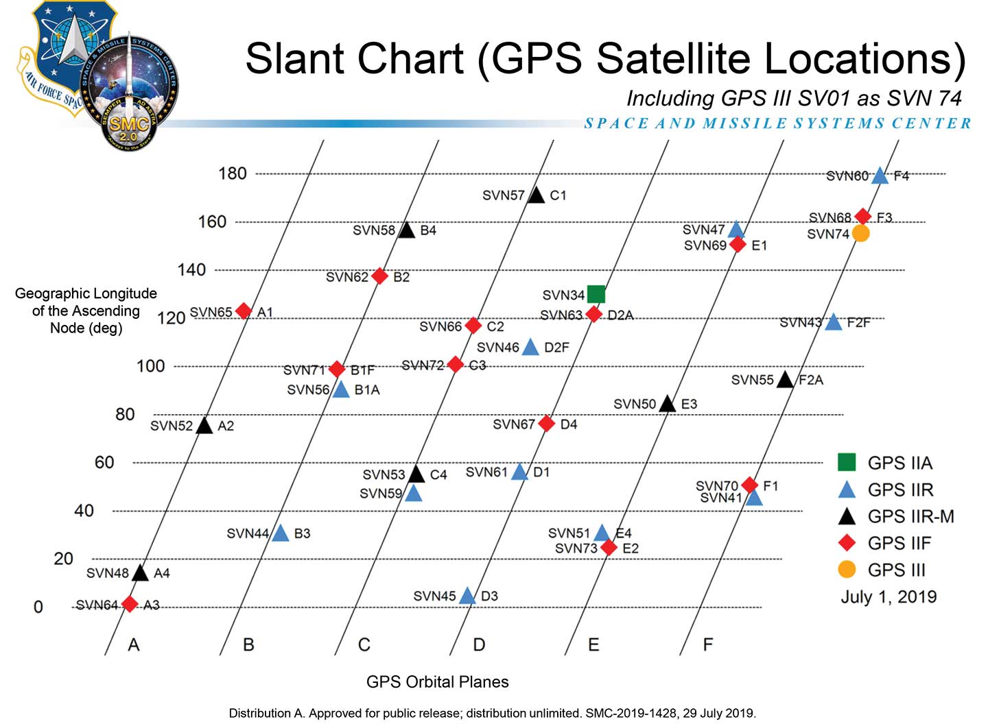
A depiction of the GPS constellation of satellites with slot and plane designations has been published by the U.S. Coast Guard Navigation Center as an easy-to-read graphic for use by the GPS user community.
Chart: NAVCEN
The chart can be found on the NAVCEN Constellation Status page and will be updated with the commissioning of new GPS satellites or upon any change in the constellation.
Collins Aerospace announced that its miniature PLGR engine – M-code (MPE-M) receiver has received approval from the GPS Directorate. Collins Aerospace’s Mike Shepherd talks more about the approval at Xponential 2019, which took place April 29-May 2 in Chicago.
On Sept. 25, the GPS Directorate will host the 2019 Public Interface Control Working Group and Open Forum to update the public on GPS public document revisions.
The meeting will collect issues and comments for analysis and possible integration into future GPS public document revisions.
The 2019 Public Interface Control Working Group and Open Forum are open to the general public. It can be attended in person or by dial-in connection.
Documents Affected
IS-GPS-200: Navigation User Interfaces
IS-GPS-705: User Segment L5 Interfaces
IS-GPS-800: User Segment L1C Interface
ICD-GPS-870: NAVSTAR GPS Control Segment to User Support Community Interface
Meeting Address: SAIC, 100 N Sepulveda Blvd., El Segundo, CA 90245, The Great Room
The GPS Directorate has released updates to the below Interface Control Documents (ICD). ICDs are the formal means of establishing, defining, and controlling interfaces and for documenting detailed interface design definitions for the GPS program.
Updated Documents
IS-GPS-200: Navstar GPS Space Segment/Navigation User Interfaces
IS-GPS-705: Navstar GPS Space Segment/User Segment L5 Interface
IS-GPS-800: Navstar GPS Space Segment/User Segment L1C Interface
ICD-GPS-240: Navstar GPS Control Segment to User Support Community Interface
ICD-GPS-870: Navstar Next Generation GPS Control Segment (OCX) to User Support Community Interface
Download or view the updated ICDs at GPS.gov or NAVCEN.
59th CGSIC Meeting Set for September
The U.S. Department of Transportation (DOT) and the Coast Guard Navigation Center (NAVCEN) have announced plans for the 59th meeting of the Civil GPS Service Interface Committee (CGSIC).
The meeting will take place Sept. 16-17 at the Hyatt Regency Miami in Miami, Florida, in conjunction with the Institute of Navigation’s ION GNSS+ 2019 conference.
CGSIC meetings are free and open to the public. Subcommittees of the CGSIC for Timing, International Information, and Survey, Mapping, and Geosciences will hold meetings Sept. 16, and a summary of these meetings will be presented to the CGSIC plenary session Sept. 17.
The meeting will include important briefings on the status of ongoing GPS programs and a keynote address by Diana Furchtgott-Roth, deputy assistant secretary, Office of the Assistant Secretary for Research and Technology, U.S. Department of Transportation.
On May 7, the GPS Directorate will hold a virtual Public Interface Control Working Group Meeting. The meeting will take place 8:30–10:30 a.m. PST.
During the meeting, the directorate will review changes to several GPS public documents to reflect how users will calculate the correct UT1 time following a leap-second transition.
The 2019 virtual Public Interface Control Working Group is open to the public. The meeting is available through dial-in only.
The meeting will update the public on GPS public document revisions and collect issues and comments for analysis and possible integration into future GPS public document revisions.
For more on the revisions,as well as dial-in and contact information, go to GPS.gov. Also see the Federal Register notice.
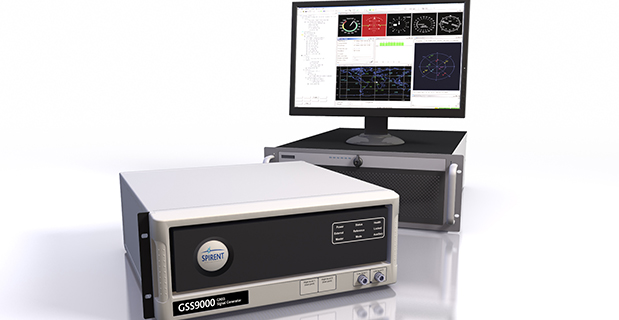
Spirent Federal Systems, provider of GPS/GNSS test equipment, has announced that its new M-code solution, SimMNSA, has been granted security approval by the Global Positioning System Directorate.
Spirent Federal is the first company to provide such a solution for simulating classified GPS signals, and is currently taking orders, the company said.
The GSS9000 simulator. (Photo: Spirent)
In 2017, Spirent Federal Systems partnered with Rockwell Collins to develop new software that will use the Modernized Navstar Security Algorithm (MNSA). This new approach of M-code simulation adds to Spirent Federal’s portfolio of classified signal simulation solutions, and will be available to authorized users of the GSS9000 series simulators.
“With the increased focus on M-code by the GPS Directorate, we are pleased that our team has paved the way in the development of SimMNSA,” said Ellen Hall, CEO of Spirent Federal Systems. “It was a great challenge to get to this point, but we are excited about what we have accomplished.”
The new test solution continues Spirent Federal Systems history of innovation and being first to market with M-code simulation software, the company said. Spirent’s GPS/GNSS solutions have supported numerous government, military and U.S. Department of Defense programs for more than 30 years.
Following the 2018 Public Interface Control Working Group (ICWG) in September, the GPS Directorate invites additional public comments on the following Proposed Interface Revision Notices (PIRNs) due to the nature of changes since the June 2018 review.
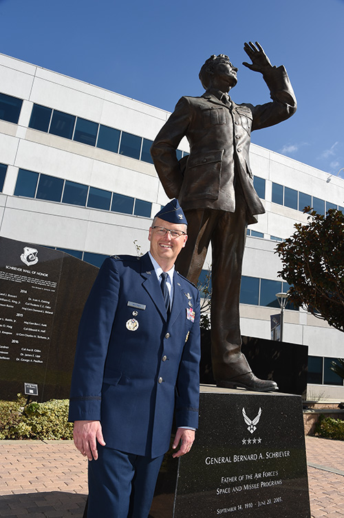
Col. Steve Whitney stands beside a statue of General Schriever at Los Angeles Air Force Base, home of the GPS Directorate. (Photo: U.S. Air Force/Joseph Juarez, Sr.)
By Col. Steven Whitney Director, Global Positioning Systems Directorate
Navigating across the world’s roads with GPS is easy. Navigating through the shifting construction zones, detours, and forks of the GPS Enterprise is not always so straightforward.
For that reason, the GPS Directorate has placed more emphasis on illustrating, both figuratively and literally, the roadmaps leading to the integration of the GPS Enterprise.
Before linking everything together, let’s start with an update on each major program effort. This way you can zoom out to see the path ahead; hopefully minimizing any “route recalculating” along the way.
Program Updates
The journey to build the new GPS III satellites has been full of twists and turns but we are now close to our destination – in this case the GPS orbit of 12,550 miles above the Earth.
We not only have 10 GPS III Space Vehicles simultaneously in production at Lockheed Martin’s manufacturing facility in Waterton, Colorado, but are also going full swing on preparations to launch our first vehicle in December 2018 on a SpaceX Falcon 9 rocket – more on this later. The GPS III satellites provide signals designed to improve the user’s ability to navigate.
In addition to the increased power and greater accuracy, GPS III adds a civil new signal, L1C, designed for compatibility with the international Global Navigation Satellite Systems (GNSS) community.
GPS IIIF. In September 2018, the Air Force awarded the GPS III Follow-on contract to Lockheed Martin. This $7.2B contract for 22 satellites was the result of a competitive process for a production effort. Based on the GPS III technical baseline, the GPS IIIF family of satellites embraces modernization and capability improvements in multiple areas.
First, a Regional Military Protection capability will provide increased anti-jam capabilities. Furthermore, a new Search-and-Rescue (SAR/GPS) payload will provide improved timeliness of global search-and-rescue operations. Additionally, a Laser Retro-reflector Array (LRA) payload will enable precise ranging measurements and the program will implement a Unified S-Band capability to address consolidation of telemetry, tracking, and commanding frequencies.
Finally, the program will host a redesigned Nuclear Detonation (NUDET) Detection System (NDS) solution that has a lower overall size and weight. We look forward to the continued partnership with Lockheed Martin and will be looking collaboratively at opportunities to add additional capabilities incrementally over the life of the 22 GPS IIIF satellite production line.
OCX, the Next Generation Operational Control Segment. Last year Raytheon delivered the initial system, known as OCX Block 0, to support the launch and on-orbit check-out of the GPS III satellites. This past year, we have actively utilized the system in a variety of exercises, training events, compatibility tests, and launch readiness events.
We also completed a comprehensive security review of the system to demonstrate our readiness to start operations. The system is ready to go. We continue to work the development of the OCX Block 1 system and are wrapping up the initial coding of the system early in 2019, leading into our integration and test campaign.
The journey over the past few years has been challenging, but we have emerged stronger, armed with better metrics, and a culture of integrated development (often called DevOps) which puts us on a path to success. There will be challenges and risks in the path ahead but rather than mountains to climb, I see these more as standard blocking and tackling of a software intensive program.
Col. Whitney next to an artist’s depiction of a GPS III satellite in orbit. (Photo: U.S. Air Force/Van Ha)
Legacy Ground Sustainment. Running in parallel to these modernization efforts is the all-important work to sustain our existing GPS infrastructure of our current Operational Control System (OCS). These sustainment efforts ensure GPS continues to be the gold standard in positioning, navigation, and timing but also are a crucial “on-ramp” to facilitate a smooth merge onto the modernized GPS capabilities.
Since 2014, the GPS program office has incrementally implemented several upgrades that not only maintain our satellite constellation delivery of GPS signal-in-space accuracy of 50 cm, but also significantly increases the cybersecurity posture of the legacy OCS.
These upgrades culminated with a deployment of the latest modification in October 2018, which finished a worldwide modernization of our entire control system hardware and software. This latest upgrade, known as Version 7.5, virtualized the network, implemented two-factor authentication, and improved encryption for mission data.
Legacy Ground Improvements. Given the delays in OCX, the Directorate is actively working two major upgrades to OCS to bridge the gap. The first is GPS III Contingency Operations (COps) modification which will allow the 2nd Space Operations Squadron (2SOPS) to command and control the GPS III family of vehicles in a mission state matching today’s legacy signals for all users world-wide. The second modification is M-Code Early Use, which enables 2SOPS to operationalize the Modernized GPS military signals (M-Code) navigation signals for the warfighter.
User Equipment. As I write this article, soldiers, sailors, marines and airmen are testing and integrating mature, next-generation GPS receiver cards providing more accurate and reliable position, navigation, and timing (PNT) solutions. In 2019, the first increment of Military GPS User Equipment (MGUE) is on track to complete card-level testing to inform Service procurement strategies.
This exciting work is the culmination of nearly two decades of modernization efforts throughout the GPS Enterprise. In the near term, we are utilizing M-Code capable lead platforms — USAF B-2 Bomber, USMC Joint Light Tactical Vehicle, USN Arleigh-Burke Class Guided Missile Destroyer, and Army Stryker combat vehicle — to prove out those capabilities.
The second increment of MGUE focuses on requirements for precision guided munitions, a joint common modular handheld unit, as well as circuit cards and components for low size, weight and power needs. With MGUE, the DoD and services are poised to have enduring PNT solutions the warfighter can leverage for years to come.
Integration Roadmaps
The delivery of individual programs is the stepping stone in the capability deliveries to the warfighter and our civilian users. However, it is our ability to unite a diverse collection of programs and stakeholders, across the GPS Enterprise, which defines our success as the GPS Green Monsters. We have done this by linking cross-program enterprise teams so the sum of the whole is greater than its parts.
Enterprise Road to Launch (ERTL). The goal is pulling together a series of firsts (new satellite, new ground system, and new launch provider), which has not been done before in the modern GPS Era, to deliver the spacecraft safely on-orbit and under control. Our journey to this historic launch has taken time and effort, and we are enthusiastically awaiting the final steps.
The first GPS III spacecraft is safely at Cape Canaveral and ready to go. The control system has been tested and run through its paces. The integrated launch team has conducted its exercises and reviews. All signs point to launch in December 2018.
The launch itself is a significant milestone, and marks a beginning of the orbital phase of GPS III. The Road to Launch team is prepared to execute the launch, the check-out and the day-to-day on-orbit housekeeping until the ground updates are complete to transfer the new GPS III satellite into the active constellation later in 2019.
Enterprise Road to Mission (ERM). The goal is bringing the GPS III satellites into the active constellation providing mission similar to today’s capabilities. A key enabler of the ERM IPT’s success is their development of the first-ever Enterprise “Integration Playbook”, which is the tangible, documented output of a significant dedicated planning effort.
The Playbook captures how all the pieces and efforts from each stakeholder community tie together to achieve Operational Acceptance of the first GPS III satellite, the USNDS payload, and the COps modification to OCS. The “Playbook” describes in clear and concise terms how these deliveries integrate across the GPS Enterprise, as well as how tasks and milestones from various stakeholders converge to achieve clear end states.
Enterprise Road to M-Code Mission, or ERM-M-Code. Shifting now to our military users, the purpose of the ERM-M-Code team is to lead the early delivery of a more robust, resilient, jamming/tampering-resistant PNT signal capability to warfighters.
The rollout of the operational M-code capability depends on the success of the M-Code Early Use modification to OCS, installation of new M-code signal monitoring equipment at sites around the globe, modification of mission planning software, Military GPS User Equipment Increment 1 development, service lead platform integration efforts, and operationalization of space receivers.
Our ultimate objective is to improve the ability of the Combined Space Operations Center (CSpOC) to respond to urgent PNT needs of the combatant commanders, as they engage more sophisticated adversaries. We remain closely aligned with our peers at USSTRATCOM, AFSPC and user communities.
Conclusion
It is an exciting time to be a GPS Green Monster! These roadmaps are by no means easy to create and execute. It is thanks to the remarkable people of your GPS Directorate that these multifaceted challenges are unraveled, aligned, and resolved. The team has worked incredibly hard this past year to position our systems for major, integrated deliveries over the next couple of years.
It has been the highlight of my career to serve with these men and women and I can’t wait to see where we — and the GPS Enterprise — go next.
Col. Steve Whitney stands beside a statue of General Schriever at Los Angeles Air Force Base, home of the GPS Directorate. (Photo: U.S. Air Force/Joseph Juarez, Sr.)
By Col. Steven Whitney Director, Global Positioning Systems Directorate
The most discussed theme in the U.S. Air Force space community over the last year has been “resiliency.” But what does that actually mean, and how can the Air Force increase resiliency in space?
The GPS Directorate took these questions to heart and thought long and hard about resiliency in our Positioning, Navigation, and Timing (PNT) service. I am pleased to report that we have made significant progress in the past year in our quest to bring a new generation of PNT technology to reality.
More importantly, our investments in space, ground, and user equipment developments are bringing real, tangible benefits towards providing a more resilient PNT service worldwide. We stand on the cusp of delivering modernized civil and military GPS signals which provide critical pieces to the puzzle.
Farther into the future, the Air Force is already exploring new, emerging technologies and capabilities to even further advance the robustness of the GPS enterprise, with the vision that GPS will always remain the “Gold Standard” for the worldwide PNT community.
Resiliency Begins with Signals
Modernized GPS signals will be the first piece of the puzzle for an overall resilient PNT solution. The community has long anticipated the beginning of the multi-GNSS era.
The GPS Directorate has embraced this future with a new L1C signal, designed cooperatively from the ground up to be interoperable with international satellite navigation systems. The signal design will greatly improve GPS reception in cities and other challenging environments.
Another important GPS signal was introduced with our GPS IIF satellites. The L5 signal is designed specifically to meet the demanding requirements for safety-of-life transportation and other high-performance applications.
This signal is broadcast in a radio-frequency band reserved exclusively for aviation safety services to ensure it has optimal spectrum protection. Together, these two new additions greater improve PNT resilience for civil users around the globe.
“The need to improve cyber security and protection quite honestly cannot wait until delivery of the Next-Generation Operational Control System (OCX). To that end, the Directorate has focused on high payoff updates for the existing operational system.”
Other measures already improve resiliency by leveraging existing signals. For example, the L2C signal, when combined with L1 C/A in a dual-frequency receiver, will enable ionospheric error correction and improve positioning and timing accuracy.
For the military, the directorate has been focused on bring Military Code (M-code) into operations. The M-code signal features advanced anti-jam, anti-spoof, and encryption features that will ensure resilient and dependable PNT solutions for the United States and its allies.
The rollout of an operational M-code capability involves all segments of the GPS enterprise, and while it has been a long time in coming, the GPS Directorate made big strides this year (see “2017 in Review”). I will touch on the progress we are making in each of our development programs.
Resiliency in Space
The GPS space segment is the next step towards a more resilient PNT architecture. Our constellation remains robust and healthy, albeit aging, with 31 operational satellites providing worldwide coverage at the time of this article. The GPS III satellites will bring additional robustness with increased power and accuracy over previous generations of satellites.
We made big strides towards launching the first GPS III satellite in 2018, and just as importantly, production is in full swing on the rest of the ten satellites. I am incredibly proud of the entire government and contractor team that is meticulously acquiring, assembling, and testing these complex machines.
GPS IIIF. Farther into the future, the directorate is preparing for the GPS III follow-on program. The Air Force will be adding important new resiliency capabilities, with added signal flexibility via a reprogrammable, digital payload and increased anti-jam support to theater with a Regional Military Protection capability. Over the coming years as the follow-on GPS III satellites join the constellation, they will revolutionize GNSS with the full complement of operational L1C, L2C, L5 and M-code signals.
Resiliency in Control Segment
As important as the satellites are, the control segment is just as integral to the overall resiliency of the GPS enterprise. The need to improve cyber security and protection quite honestly cannot wait until delivery of the Next-Generation Operational Control System (OCX).
To that end, the directorate has focused on high payoff updates for the existing operational system.
For example, we acquired and deployed software-based GPS monitor station receivers, known as Monitor Station Technology Improvement and Capability (MSTIC) receivers, to replace the aging fleet of existing monitor-station receivers.
The functionality and expandability of the MSTIC receiver design will facilitate adding further capabilities such as M-code signal monitoring, and even civil L1C, L2C, and L5 signal monitoring.
The GPS Directorate also deployed a new cybersecurity monitoring suite to enhance cyber defenses. This new suite is in operation today at the GPS Master Control Station (MCS).
Beyond just improving our cyber protection, the Air Force has also stepped out on several OCX off-ramps to support the launch and operation of the GPS III satellites and mitigate risk of further OCX delays.
The Contingency Operations (COps) program modifies the existing Operational Control System (OCS) to allow the first GPS III satellites to join the operational constellation. The Air Force also initiated a companion program, M-code Early Use (MCEU) to further update OCS to provide limited M-code operations.
Together, these two programs provide critical interim steps towards fielding a more resilient constellation.
The OCX program provides the ultimate cyber protection and assurance needed for the GPS enterprise. After emerging from program recertification this year, the program has focused heavily on improved software system engineering and embracing software industry best practices, such as adopting DevOps and greater software automation.
The program has even leveraged Amazon Web Services’ Gov’t Cloud capability to provide more responsive development and test environments. While the program has a long ways to go, the government and prime contractor, Raytheon, are committed to delivery to ensure a robust and secure ground infrastructure.
User Equipment: Final Piece
The final piece of the resiliency puzzle for military customers is our user equipment segment. The directorate has made big strides in delivering the first set of modernized receiver cards for the Military GPS User Equipment (MGUE) Increment 1 program.
These advanced cards will enable platforms across the U.S. Department of Defense to leverage the new M-code signal, providing a tremendous boost in both anti-jam and anti-spoof capability.
They will also provide the latest in cryptography to ensure secure, robust protection for the United States and its allies.
Down the road, the Department of Defense is evaluating additional capabilities and platforms for the MGUE Increment 2 program.
Currently envisioned to address precision guided munitions, space receivers, and a modernized handheld unit, the Increment 2 program will be laying out an acquisition plan in this coming year to further adoption of M-code signals throughout the military.
A consideration for the future of user equipment will be exploring processing multi-GNSS signals. While no decisions have been made, multi-GNSS could offer opportunities for even additional resiliency.
Final Thoughts
This is an exciting time for the GPS enterprise.
We stand on the cusp of a new generation of capabilities that will usher in a huge increase in PNT resiliency and robustness. I am astounded at the quality of work that is presented at the many GNSS and PNT conferences around the world, and it is both exciting and humbling to see the community continuing to innovate ways to increase accuracy, integrity, availability, continuity, and performance.
Likewise, I am honored to lead the men and women of the GPS Directorate as we strive to deliver on our commitments and find new, innovative ways to provide robust and resilient PNT to the world.
This dedicated team is poised and ready to lead us into the future, and we look forward to working with the entire community to continue delivering the GPS “Gold Standard” in space-based PNT.
Lockheed Martin’s GPS III clean room in Littleton, Colorado.
By Col. Steven Whitney Director, Global Positioning Systems Directorate
This year saw the GPS enterprise take big strides towards completing major acquisition and development milestones and overcoming significant program challenges.
As we close out the year, the GPS Directorate stands poised to launch the first GPS III satellite in 2018.
The GPS III prime contractor, Lockheed Martin, successfully placed GPS III Space Vehicle (SV) 01 into storage in late February. Following a comprehensive engineering review, SV-01 was determined to be Available For Launch in September.
Road to Launch. The GPS Directorate also kicked off its inaugural Road to Launch campaign this year, and the satellite recently completed a final factory mission readiness test in November. Just as importantly, production is in full swing on the remaining nine satellites with the SV-02 Available For Launch declaration expected early in 2018.
The GPS Directorate was also hard at work preparing the request for proposal (RPF) for a follow-on production contract that will add up to 22 additional GPS III satellites. As the U.S. Department of Defense (DoD) finalizes requirements for the program, we stand ready to release the RFP by the end of the year.
OCX. While the Next Generation Operational Control System (OCX) continued to be a focal point for the DoD, the program has made progress in 2017 following a program restructuring. OCX completed the first integrated live-satellite launch rehearsal with GPS III in August.
A fitting capstone to the year’s achievement was the long awaited delivery in November of the initial version of OCX, known as the Block 0, to support launch and checkout of GPS III satellites. But while these are encouraging signs, there is still a long road to delivery of the full suite of capabilities in 2022.
The Contingency Operations (COps) program remained on track this year for delivery in 2019 to support interim GPS III operations. The program completed two (out of three) major software builds this year. The U.S. Air Force initiated a companion program, M-Code Early Use (MCEU), to enable limited M-code operations. MCEU is on target to complete its Preliminary Design Review in November 2017.
MGUE. Early this year, our Military GPS User Equipment (MGUE) program achieved acquisition Milestone B, allowing it to enter the Engineering and Manufacturing Development phase.
Just as importantly, MGUE successfully completed two major risk-reduction events. First, the U.S. Army successfully demonstrated 81-mm mortar precision-guided munitions integrated with MGUE receiver cards to complete the first ever M-code guide-to-hit tests in March.
The Air Force then demonstrated a prototype MGUE navigation unit integrated into the B-2 bomber in four successful flight tests. These tests are an important step towards anti-jam, anti-spoof GPS capability, ensuring secure, robust protection for the United States and its allies.
So, as we close this year, I am encouraged by our recent successes, but with a clear understanding of the many challenges ahead on the road to GPS modernization. We remain fully committed to meeting our program commitments with transparency.