Tag: GPS Directorate

  • Directions 2017: GPS navigates the future

    Directions 2017: GPS navigates the future

    I’m proud to be a part of the accomplishments of the men and women of the Space and Missile Systems Center’s Global Positioning System Directorate at Los Angeles Air Force Base in El Segundo, California. The year has been extremely challenging, but looking back on 2016, we have taken real steps forward to modernize the GPS Enterprise and the way we do business. I’d like to share some of our major accomplishments (see “2016 Accomplishments” below) and challenges, and provide some insights for 2017 and beyond.

    steve_whitney-gpsdirectorate-w
    Col. Steven Whitney. (Photo: USAF)

    Civil Partnerships

    While much of our focus is on military capabilities, GPS is a global utility with very strong ties to the civil community. The same principles of transparency and communication are cornerstones of our relationships with the various stakeholders.

    One example of this is our work with the Federal Aviation Administration and the Department of Transportation, where the safety-of-life applications are a key element of our discussions. To ensure a transparent, communication-rich relationship, we hold quarterly program management reviews with these organizations and their stakeholders.

    The GPS Directorate continues to actively participate on a number of committees, such as the Civil GPS Service Interface Committee, that are key to maintaining ties to our civil stakeholders and ensuring that we have an effective flow of information both to and from the Directorate.

    We are currently engaged in the DOT-led Adjacent Band Compatibility study, initiated by the National Space-Based PNT Executive Committee. This year will see the culmination of the effort to determine power levels from potential future adjacent-band sources that are compatible with existing and evolving GPS receivers, and serve as a foundation to determine power levels compatible with evolving GPS/GNSS receivers.

    This study exemplifies our strong ties with the greater GPS community, as well as my push for the Directorate’s efforts to be as transparent as possible, execute data-driven decisions, and be guided by widely accepted international standards.

    Space Segment

    A key milestone occurred Feb. 5, 2016, with the launch of our 12th and final GPS IIF satellite. This marked the end of an extremely successful GPS IIF launch campaign and our most aggressive launch schedule in the last 20+ years: eight successful launches in 24 months!

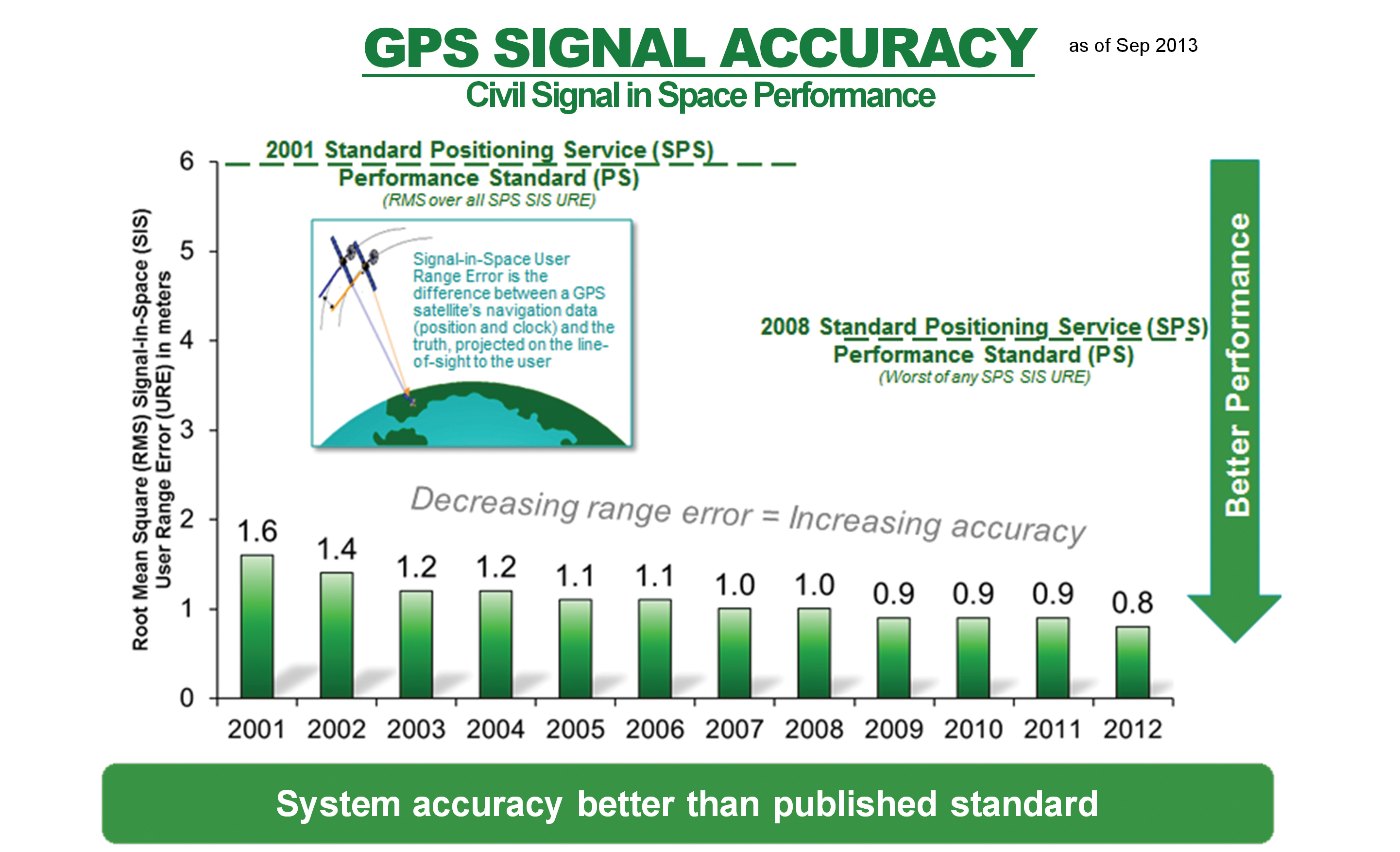
    The addition of the GPS IIF satellites to the constellation enabled the system to reach its best performance day ever on May 11, 2016, achieving 36.5-centimeter accuracy in average user range error.

    Col. Whitney with the Green Monster, mascot of the U.S. Air Force GPS Directorate.
    Col. Whitney with the Green Monster, mascot of the U.S. Air Force GPS Directorate. (Photo: USAF)

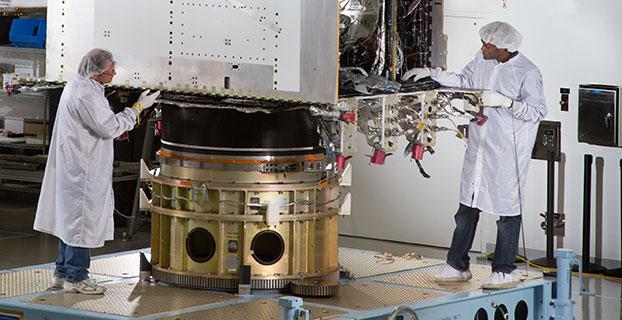
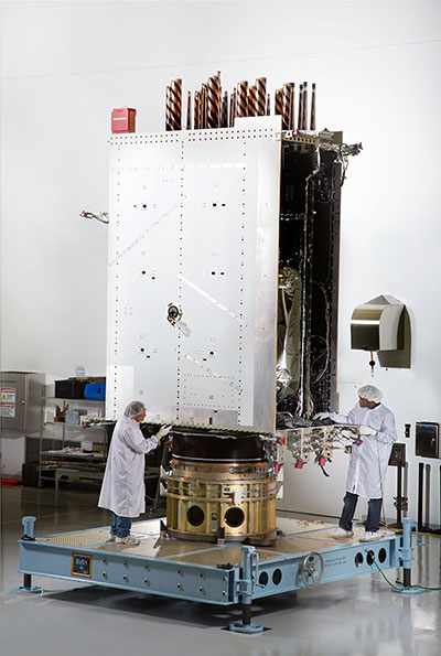
    Moving over to our next generation GPS III satellites, SV-01 continues to make steady progress. In August, the team executed successful functional and physical configuration audits with Lockheed Martin, completing a key task on the road to achieving our available for launch (AFL) date. The AFL declaration signifies completion of production activities, and allows initiation of the Mission Readiness Campaign for launch upon Air Force direction.

    As we march towards AFL, we are tackling several technical challenges, including a capacitor issue discovered during our investigation of SV-03 flight hardware tests. This capacitor is used in many places throughout the navigation payload. Our investigation uncovered inadequate qualification processes by a major subcontractor. Exercising due diligence, the Air Force is now verifying both the build quality of the entire capacitor manufacturing process and production lot via additional capacitor qualification life testing. This activity delayed our AFL until December 2016, approximately a four-month delay from our previous forecast.

    The program is also working to solve several other technical challenges as we progress to completion. SV-01 testing uncovered electro-magnetic interference between a payload component and a hosted payload. Testing also uncovered electron impact issues on the L-band antenna elements. In partnership with Lockheed Martin, the program developed corrective action and design mitigations for both of these issues and is implementing these steps within our production flow for all the SVs. Of course, all these issues together have led to increased cost and contributed to delays in final delivery.

    In the coming year, SV-02, the second GPS III satellite, will also be progressing towards completing production. Currently, all of the SV-02 sub-assemblies have been received by Lockheed Martin and are being integrated into the spacecraft. The next major step in the production flow for SV-02 will be to mate it with its propulsion core.

    Recently, we completed negotiations with Lockheed Martin to extend the production line with purchases of SV-09 and SV-10. These satellites will be technically equivalent to SV-01 through SV-08. This $395 million purchase of two satellites marks a significant affordability milestone for the procurement of GPS III satellites.

    Looking ahead, we are analyzing how to acquire satellites beyond SV-10. We are executing a phased strategy which starts first with determining the viability of a GPS III production design existing beyond the current contractor. We awarded an initial phase of contracts to the Boeing Company, Lockheed Martin Space Systems Company, and Northrop Grumman Aerospace Systems in May 2016 to provide a feasibility assessment of the readiness of their satellites designs. In this phase, the contractors will provide a GPS III production design, manufacturing plans and a navigation payload brassboard test report, along with manufacturing/production processes and facilities maturity.

    We are also collaborating closely on an Air Force Research Laboratory Space Vehicles Directorate activity, the On-orbit Reprogrammable Digital Waveform Generator program, as an opportunity for the three contractors to develop advanced GPS L-band navigation signal processing capabilities in a smaller, more efficient package. This effort could potentially provide future satellites enhanced security in contested environments, more capable signal generation, and additional GPS waveforms to meet the growing needs of both military and civilian users.

    Looking further ahead, the second phase is envisioned to be a full and open competition with contract awards starting in 2018. Contractors will be required to deliver the first satellite in time to support constellation sustainment commitments.

    Control Segment

    Our Control Segment consists of both OCX and our existing Operational Control Segment at Schriever Air Force Base, Colorado. The OCX program has struggled with many challenges through the years, producing a cost and schedule growth on OCX that exceeded the prescribed thresholds — in our case, a 25 percent cost growth against the approved Program Baseline.

    I notified the Secretary of the Air Force on June 14 of this development, and on June 30 the Air Force declared a critical Nunn-McCurdy breach on the OCX program. The Nunn-McCurdy process is a mechanism for Congress to maintain oversight of DoD programs and requires the Office of the Secretary of Defense to conduct a review leading to a decision to either certify as critical to National Security or terminate the program.

    The GPS Directorate and Raytheon, the OCX prime contractor, worked closely with teams conducting this in-depth, comprehensive review. The result was determined on Oct. 12 that OCX is essential to national security that no alternatives exist to meet requirements at less cost, remaining costs for the restructured program are reasonable and a higher priority than programs whose funding must be reduced to accommodate the growth, and management structure for the program is adequate.

    With the review behind us, our challenge is to move forward with a stronger, healthier, more focused OCX program. To accomplish this, we are focused on several major areas: stronger systems engineering practices, establishing a single common hardware/environments baseline, greater software installation automation, and implementing industry standard software development processes.

    One of our first milestones next year will be the delivery and deployment of OCX Block 0 in the summer of 2017. Block 0 is the GPS III Launch and Checkout System and provides a subset of the full OCX capabilities needed to launch the GPS III satellites and perform early on-orbit spacecraft bus checkout.

    This delivery starts the drive for our inaugural launch of GPS III SV-01 in the spring of 2018. Raytheon completed two Block 0 key milestones since March 2016, and is now in formal qualification testing before it is deployed to operations early next year. The next year will see OCX development focused on Block 1. It provides the Initial Operating Capability to command and control all GPS satellites and enable the PNT mission, including the international L1C signal and advanced M-code features and capabilities.

    Because OCX Block 0 is not designed to control the GPS III navigation payload, we are modifying the existing OCS to control GPS III satellites under Contingency Operations, or COps. COps will allow operation of the GPS III satellites launched prior to OCX Block 1 delivery in 2021, and provides the Air Force the ability to fly GPS III satellites at a capability level commensurate to a GPS IIF.

    Our COps program has made good progress, completing its Preliminary Design Review last May and successfully passed Milestone B in September. COps is on track to hold its Critical Design Review in November, with delivery planned for the spring of 2019. We are exploring other potential OCS modifications to hedge against further delays in OCX.

    Our OCS sustainment team in Colorado Springs recently completed the largest system update in program history. This update is part of our focus to refresh and bolster the cyber posture of the GPS architecture, and modernize the GPS control segment mission servers and hosted commercial software. These upgrades will protect against infiltration of cyber threats and enable improved data traffic logging for network situational awareness to protect this global utility.

    User Equipment Segment

    Like our other segments, our User Equipment segment had a very challenging but successful year. The MGUE program has worked steadily with our entire industry team, L-3 Communications, Raytheon, and Rockwell-Collins, to complete and test MGUE Increment 1 production prototypes. These Final Test Articles, or FTAs, started delivering this summer and are now capable of acquiring and actively tracking live-sky M-code. With the initial risk reduction testing phase complete, the Directorate will now use the FTAs to perform MGUE developmental testing and verification and hardware qualification testing.

    The L-3 design was also the first on our program team to achieve security certification this October, which marks the very first security-certified M-code receiver card. This not only validates the L-3 design and production, it also validates the GPS security certification process, an enduring function for the Directorate in working with industry. This certification also leads the way for the product to be available to a wide variety of users across the DoD.

    While progress in MGUE has been significant, creating the next-generation of secure, anti-jam, anti-spoof receivers has been more time-consuming and costly than expected. The drive to support warfighter needs for greater performance drives a diverse set of requirements across the DoD. The Air Force made a concerted effort to improve the resiliency of the MGUE receivers, adding complexity to the program. Combined, these challenges have led to extended delivery schedules for the program.

    In the coming years, the MGUE team will lead efforts to integrate MGUE cards into four lead DoD platforms: the Air Force’s B-2 bomber, the Navy’s Arleigh Burke-class destroyer, the Army’s Distributed Defense Advanced GPS Receiver Device for the Stryker armored fighting vehicle, and the Marine Corps’ Joint Light Tactical Vehicle.

    The four lead platforms provide pathfinder integrations and operational testing for the entire DoD community as we move into the modernized GPS era. The program office has already been working closely with the B-2 Program Office and the Joint Service System Management Office in fielding an M-code capable flight prototype Miniaturized Airborne GPS Receiver.

    We have worked jointly on this first lead platform integration effort to field the first ever MGUE receiver integration into a higher order prototype unit. These efforts yielded tremendous integration insights. Prototype lab testing demonstrated live-sky tracking of C/A, Y and M-codes; testing of MGUE connected with a new B-2 flight antenna; and culminating in the first end-to-end demonstration of M-code capability.

    In 2017, the GPS Directorate will set the acquisition strategy and plan forward for the MGUE Increment 2 program, addressing our long-term strategy for Application Specific Integrated Circuits, as well as meeting the needs of future platforms such as precision guided munitions, space receivers, and a modernized GPS handheld.

    The Space Enterprise Vision

    Earlier this year, General John Hyten, former commander of Air Force Space Command, announced the Space Enterprise Vision. The SEV is the result of an AFSPC study that looked at ensuring national security space capabilities in a contested environment, with an emphasis on improved resiliency. In the PNT mission area, there are many ways to provide greater resiliency in-line with General Hyten’s SEV. One that we are leaning forward and looking very hard at is multi-GNSS possibilities.

    At the recent Institute of Navigation conference, many presenters noted that for the consumer market, the multi-GNSS era has already begun. Potential incorporation of non-GPS signals into military user equipment is still under review, but certainly offers the possibility of improving resilience to jamming, spoofing, and operations in obstructed terrain. The broader GPS community is developing approaches to assess multi-GNSS integrity, and we are working with those community members to evaluate the potential impacts to our GPS architecture, especially the ground.

    Another resiliency initiative we are participating in is a DOT-led effort known as Advanced Receiver Autonomous Integrity Monitoring backed by PNT experts from the labs and academia. Once the technical aspects are well understood and the policy decisions are made, the GPS Directorate will be well positioned to take advantage of this opportunity.

    Conclusion

    2016 has been a very challenging and successful year. Looking forward into 2017 and beyond, we have numerous challenges across all segments of the Enterprise — OCX, GPS III, and MGUE — to deliver a modernized architecture. The men and women of the GPS Directorate and our Industry partners are truly some of the hardest working people I have ever had the opportunity to work with. It is their passion and dedication that has allowed us to continue to deliver the Gold Standard. It is my honor to serve with, and for, them.


    2016 Accomplishments

    gps-ocx-raytheon-200x150Our GPS Next-Generation Operational Control System, or OCX program, received the majority of the press attention this year. OCX has struggled to overcome information assurance challenges, as well as poor systems engineering processes and planning from the outset of the program. The cost and schedule growth triggered a rigorous review by the Office of the Secretary of Defense.

    The outcome, we believe, will be a restructured, more executable program that is implementing stronger systems engineering practices and industry-standard software development processes.  We still have a ways to go to be successful, but realize we must deliver the capability to command our GPS satellites and will continue to explore programmatic off-ramps should the OCX program falter.

    The past year also saw us bring to a close the GPS IIF production and deployment activities with the successful launch of our 12th and final GPS IIF satellite. Our GPS constellation remains healthy, stable and robust with 31 operational space vehicles: 12 GPS IIR, seven GPS IIR-M, and 12 GPS IIF.

    We ushered in the GPS III era with the completion of Space Vehicle-01 thermal vacuum testing late in 2015 in an unprecedented 72 days. We have, however, uncovered several technical issues challenging our availability for launch. As we ready SV-01, a tremendous effort is ongoing to fully investigate and exonerate these issues to ensure our satellites deliver the capabilities you’ve come to expect from the Gold Standard.

    This year our partners in the Launch Enterprise Directorate awarded a GPS III launch services contract to the Space Exploration Technology Corporation, or SpaceX — their first National Security Space System launch.

    Finally, our Military GPS User Equipment (MGUE) program delivered its first set of Military Code compliant production prototypes for developmental testing and integration. Just as significant, the MGUE program granted the first-ever full security certification to contractor L-3 Communications. These major GPS modernization milestones are successful initial steps, but the progress in delivering the most secure, anti-jam, anti-spoof GPS receivers ever has taken longer than expected, and a great deal of work lies ahead.

    This is by no means an exhaustive list of the year’s accomplishments and challenges, but it demonstrates that we are continuing to modernize the GPS system and maintain transparency on our commitments.

  • Talen-X gets GPS Directorate security approval for BroadSim

    Talen-X gets GPS Directorate security approval for BroadSim

    Talen-X has been given security approval by the GPS Directorate, allowing BroadSim to create and process Y-Code while in a classified environment.

    BroadSim is a software-defined GNSS simulator that enables users to easily model true and spoofed signals. BroadSim was developed to simplify advanced jamming and spoofing scenarios with Navigation Warfare (NAVWAR) testing in mind.

    BroadSim supports high dynamics, advanced jamming, spoofing and encrypted military codes.

    Powered by Skydel’s SDX 1000-Hz software simulator engine, BroadSim can simulate multiple constellations including GPS, GLONASS, Galileo and BeiDou.Photo: Talen-X

    Software features:

    • Capable of generating and simulating multiple signal types
    • GPS L1, L2 with C/A, P, Y and M
    • GLONASS G1 and G2
    • Galileo E1 and E5
    • BeiDou B1 and B2
    • Intuitive control using Skydel’s SDX software
    • Utilizes four RF outputs, each with multiple simultaneous constellations
    • Generates high-fidelity jamming and interference signals

    BroadSim hardware includes a generator and controller with two integrated commercial-off-the-shelf USRP radios, an integrated OctoClock-G with GPS disciplined oscillator, four frequency-independent transmit and receive channels and a UBX-160 RF daughterboard.

  • Mayflower awarded defense MGUE contract for GPS receiver modernization

    Mayflower awarded defense MGUE contract for GPS receiver modernization

    Mayflower Communications Company Inc. will develop a small security-certifiable GPS module for the United States Air Force’s Modernized GPS User Equipment (MGUE) Program.

    The Mayflower NavAssure 125a GPS receiver.
    The Mayflower NavAssure 125a GPS receiver.

    Mayflower was awarded a Phase III SGUE (Small GPS User Equipment) contract with the U.S. Air Force Research Laboratory sponsored by the Space and Missile Systems Center/GPS Directorate (SMC/GPSD).

    Under the contract, the company will develop a small SWaP (Size, Weight, and Power) security certifiable Common GPS Module (CGM).

    Mayflowers’ small SWaP GPS receiver technology will allow the Department of Defense (DoD) and its agencies to benefit from increased competition, enhanced capability and reduction in overall program costs to DoD program managers and prime contractors in upgrading their navigation systems to the modernized M-code receiver.

    Mayflower’s SGUE program is aimed at the development of advanced GPS receiver technology to support future military GPS requirements.  The goal of the program is to develop a NAVWAR (Navigation Warfare) compatible CGM form factor that will support SWaP-constrained military users.

    The SGUE CGM development effort will expand Mayflower’s military GPS receiver product line to include modernized NavAssure-M product offerings so that current customers will have a form-fit-function upgrade path from SAASM to MGUE.

    “Mayflower is a leader in small SWaP and miniaturized military GPS receiver and anti-jam products,” said Triveni Upadhyay, Mayflower founder and CEO. “I am confident in the quality and innovation expertise of our GPS engineering team to successfully develop the SGUE CGM. The development of small SWaP MGUE form factors, enabled by SGUE CGM, will have a significant impact in the M-Code market, providing secure modernized GPS signals to the warfighters and lowering total ownership costs on many military programs.”

    “The Air Force is very pleased to see innovative GPS technology developed under its SBIR Program to find commercialization opportunity in the MGUE market. Mayflower has performed well and we are confident of the SGUE program success,” said Dana Howell, Air Force Research Laboratory (AFRL) program manager.

    “The AFRL/GPSD objective in the SGUE Program is to advance MGUE technology and make it affordable to the warfighter,” said Eddy Emile, chief of the Advanced Technology and International Branch, GPS Directorate. ”

    The SGUE Program fits the need and will lower the cost to the user by increased competition enabled by the SGUE Program.”

    According to Mayflower, the NavAssure-M MGUE receiver form factors, focused toward small SWaP GPS receiver applications, will be backward compatible to SAASM, therefore, lowering the platform integration cost and total life-cycle cost.

  • Directions 2016: GPS — dedicated to excellence

    Directions 2016: GPS — dedicated to excellence

    Col. Steve Whitney, director, Space and Missile Systems Center’s Global Positioning Systems Directorate.
    Col. Steve Whitney, director, Space and Missile Systems Center’s Global Positioning Systems Directorate.

    By Col. Steve Whitney

    The year 2015 was an exciting one to assume leadership of the Global Positioning Systems Directorate. I’ve witnessed the men and women of our team accomplish some amazing things, across all of our efforts to modernize the constellation, and would like to take a moment to share our progress over the past year and set the vision for 2016 as we remain dedicated to excellence.

    The past year has been another outstanding one in terms of delivering capability on-orbit. We’ve continued the pace from last year, placing another three new satellites into space, most recently including the launch of our 11th GPS IIF satellite, built by Boeing. This launch marks the 18th satellite to broadcast the Military Code (M-code) and second civil signals (L2C). Each time the dedicated professionals from government and industry, representing many, many organizations, have come together to show the world the gold standard.

    GPS III. In the development of our next generation of satellites, the GPS team continues to make progress. In September, we completed flight qualification of the navigation payload and its software — many of you recall that this area has been a challenge for us over the years, and I wanted to share this success. Additionally, the first GPS III satellite entered into thermal vacuum testing at prime contractor Lockheed Martin’s facility in Waterton, Colorado, in October.

    Thermal vacuum testing, or TVAC, is one of the last major events in the assembly and integration flow of the satellite and will prove out the hard work of the team. This first GPS III satellite is scheduled to be available for launch by the end of 2016. Lastly, we aren’t losing focus on the rest of the development units, as the second GPS III space vehicle is over 95 percent delivered and integrated at the GPS III processing facility.

    OCX. Over in the development of the ground segment, it’s no secret we’ve had very significant cost and schedule challenges in the development of the GPS next-generation system, OCX. Right now, we are engaging with both our industry partner, Raytheon, and the Department of Defense leadership to plot a way forward to deliver these much-needed capabilities. This effort is intended to improve both Positioning, Navigation, and Timing (PNT) capabilities and cyber-security posture in increasingly contested, congested and competitive space and cyber domains.

    User Equipment. The third area of our modernization efforts is our work on user equipment. Our military user equipment division continued to make acquisition history by pursuing a commercially driven strategy with all three contractors: L-3 Interstate Electronics Corporation, Rockwell Collins and Raytheon Space and Airborne Systems. They started the year by taking prototype cards to field exercises such as RED FLAG and are currently in full developmental testing of the functioning receiver cards. 2015 was an exciting year, and I’m proud to say 2016 will be no different.

    As we enter 2016, I’d like to reemphasize a challenge my predecessor Brig. Gen. Bill Cooley laid out in his 2015 Directions article, “What It Takes to Make a Gold Standard.” A challenge that GPS manufacturers worldwide innovate and build products that utilize modernized civil signals and the improved PNT capabilities brought by the Civil Navigation message. After all, in February 2016 we will launch the 19th satellite to broadcast M-code and L2C signals as well as the 12th satellite to broadcast the third civil signal, L5. With 19 satellites providing global coverage of L2C, it’s now up to industry to take advantage of these capabilities and pave the way towards modernized civil navigation.

    New Capabilities. For the first time in history, civil users will have access to what has been available to military users since the inception of GPS, full use of dual-signal frequency accuracy. This, combined with other advances, translates into increased PNT accuracy and resiliency for users worldwide. It’s time for the civil community to develop receivers that take advantage of these capabilities and usher in an era of more robust civil navigation.

    The February 2016 launch also marks the end of an era. It is the 12th and final GPS IIF satellite to launch, presenting a finale to one of the most aggressive launch campaigns in recent history: seven GPS IIF satellites in 21 months! This satellite is the last GPS satellite considered “second generation,” a generation that began operations in 1989.

    In total, Generation II GPS launches will have spanned over 28 years comprised of 61 space vehicles amongst five different blocks: II, IIA, IIR, IIR-M and IIF. Over these years, characteristics such as User Range Error (URE) have continuously improved, hallmarking the success of the GPS developers and operators past and present. In fact, from 2001 to 2014, URE was nearly cut in half, going from an annual average of 1.6 meters to just 0.7 meters for the civil user. These improvements will continue as we launch the next-generation GPS III satellites.

    In preparation for continued success into the future, 2016 will also be the year the GPS Directorate begins acquisition of GPS III space vehicles 11+. On July 3, 2015, the Office of the Secretary of Defense for Acquisition, Technology and Logistics approved the acquisition strategy for the GPS III space vehicles 11+ Production Readiness Feasibility Assessment to verify if capable GPS III production designs exist beyond the current GPS III contractor. The results of the GPS III Production Readiness Feasibility Assessment will shape and inform a GPS III space vehicles 11+ follow-on production acquisition strategy in the FY17 timeframe.

    Service. Also in 2016, the GPS Directorate will reaffirm our commitment to excellence and providing unparalleled service and capability. Challenges remain ahead, but the GPS Directorate is dedicated to delivering a ground system necessary for command and control of both today and tomorrow’s GPS enterprise. This includes the GPS Directorate’s pursuit of aggressive and innovative strategies to meet interim and future needs such as increasing the resiliency of the current ground system and investigating means for launching GPS III satellites as soon as possible so they are ready for operation at full capability with the completion of a modernized ground segment.

    Just this past year, we successfully accomplished several “hardening” efforts of the current ground system, adding to its robustness against the threats of today and tomorrow. Another endeavor we are working on is providing options to higher headquarters for the early use of M-code.

    The modernized GPS user equipment (MGUE) program will continue to pursue an innovative and aggressive acquisition strategy in 2016. Next year will kick off integrating receiver cards into service nominated lead platforms, which include the Defense Advanced GPS Receiver Distributed Device or D3, Joint Light Tactical Vehicle, Arleigh Burke-class Destroyer’s navigation system, and the B-2 Spirit. These efforts culminate with operational testing and eventually allow services to procure receiver cards directly. Over the next 12 months, the GPS Directorate also plans to begin work on a modernized GPS handheld, ensuring airmen, marines, soldiers and sailors have access to portable, accurate, and resilient position, navigation and timing powered by M-code. As MGUE is integrated into a myriad of DoD systems over the coming years, our users will continue to have the assured PNT needed to win today and tomorrow’s fight.

    Team. Finally, you can count on the professionals of GPS Directorate’s team to continue to exhibit acquisition excellence. It’s been six months since I assumed leadership of the GPS Directorate, and I am amazed every day with the passion and accomplishments of our people — which includes military, civilian, support contractors, federally funded research and development center partners and our industry partners. I feel privileged to work with each and every one of them on daily basis and look forward to what 2016 has in store for us all.

    A final thanks to you, the GPS user. With over 4 billion users and an ever growing-economic impact, you motivate us to continue to improve and assure this vital mission.

  • First GPS III Satellite Ready for Harsh Environment Testing

    First GPS III Satellite Ready for Harsh Environment Testing

    In April, Lockheed Martin fully integrated the U.S. Air Force’s first next generation GPS III satellite at the company’s Denver-area satellite manufacturing facility.  The first in a design block of new, more powerful and accurate GPS satellites, GPS III Space Vehicle One is now preparing for system-level testing this summer.
    First Photo a GPS III Satellite: In April, Lockheed Martin fully integrated the U.S. Air Force’s first next-generation GPS III satellite. GPS III Space Vehicle One is now preparing for system-level testing this summer.

    Using a 10-ton crane, Lockheed Martin engineers and technicians gently lowered the system module of the U.S. Air Force’s first next generation GPS III satellite into place over its propulsion core, successfully integrating the two into one space vehicle.

    The April systems integration event brought together several major fully functional satellite components. The system module includes the navigation payload, which performs the primary positioning, navigation and timing mission. The functional bus contains sophisticated electronics that manage all satellite operations. The propulsion core allows the satellite to maneuver for operations on orbit.

    “The final integration of the first GPS III satellite is a major milestone for the GPS III program,” said Mark Stewart, vice president of Lockheed Martin’s Navigation Systems mission area. “This summer, SV 01 will begin Thermal Vacuum testing, where it will be subjected to simulated harsh space environments. Successful completion of this testing is critical as it will help validate our design and manufacturing processes for all follow-on GPS III satellites.”

    Lockheed Martin is under contract to build eight GPS III satellites at its GPS III Processing Facility near Denver, a factory specifically designed to streamline satellite production.

    GPS III space vehicle one (SV 01) is the first of a new, advanced GPS satellite design block for the Air Force. GPS III will deliver three times better accuracy, provide up to eight times improved anti-jamming capabilities, and extend spacecraft life to 15 years — 25 percent longer than the satellites launching today. GPS III’s new L1C civil signal also will make it the first GPS satellite interoperable with other international global navigation satellite systems.

    The GPS III team is led by the Global Positioning Systems Directorate at the U.S. Air Force Space and Missile Systems Center. Air Force Space Command’s 2nd Space Operations Squadron (2SOPS), based at Schriever Air Force Base, Colorado, manages and operates the GPS constellation for both civil and military users.

  • What Is a Brigadier? And as a GPS User, Why Do I Care?

    What Is a Brigadier? And as a GPS User, Why Do I Care?

    Col. William Cooley, Director, U.S.A.F. Global Positioning Systems Directorate.
    Col. William Cooley, Director, U.S.A.F. Global Positioning Systems Directorate.

    This is the story we ran in GPS World magazine just moments after the announcement was made that Colonel William Cooley, Ph.D., director of the GPS Directorate, was nominated by President Obama to the U.S. Senate for appointment to the rank of Brigadier General in the United States Air Force (USAF).

    Colonel William Cooley, director of the Global Positioning Systems Directorate, has been nominated by President Obama to the Senate for appointment to the rank of brigadier general, United States Air Force, according to an announcement by Secretary of Defense Chuck Hagel. He is the first SPO director in many years to be nominated for general officer rank, according to Don Jewell, GPS World’s contributing editor for defense.

    Cooley is currently serving as senior materiel leader and director, Global Positioning Systems Directorate, Air Force Space Command, Los Angeles Air Force Base, California.

    “This is a great accomplishment for Bill and for the GPS community,” Jewell said. “We are all certainly very proud of him and his accomplishments and his unflagging support for the PNT community globally.”

    “This nomination is an outstanding achievement as it clearly demonstrates continued senior leadership confidence in his ability to lead the men and women in our Air Force. We have been privileged to see that for ourselves here at SMC,” said Samuel A. Greaves, Lieutenant General, USAF, Commander, Space and Missile System Center.

    Col. Cooley authored GPS World’s Directions 2015 article on the outlook for GPS in our December issue,What It Takes to Make a Gold Standard.”

    So What?

    For those of us who have spent our lives as military “brats” and/or as members of the U.S. military, announcements such as this are certainly great news, but we tend to take them in stride, as this is the way promotions to the General Officer ranks have always been announced. However, shortly after this short article appeared, I received numerous emails that, after extending congratulations to Colonel Cooley, tended to fall into specific categories:

    1. So what? Why should I care?
    2. Obviously promotions are a good thing, but why is this one so important?
    3. What is a brigadier general anyway?
    4. The Air Force does not have brigades, so how can he be a brigadier general?
    5. How many different kinds of generals are there, and where does a brigadier general place if you put them in order?

    Our editor-in-chief, Alan Cameron, had some of the same questions asked of him, so we thought we would briefly put this announcement in perspective for those of you not steeped in military history and lore. I will concentrate on the USAF, United States Air Force, as this is most pertinent to our discussion concerning Colonel Cooley. I will add links to rank charts and explanations for the other services as well. I will concentrate on the officer ranks for the purpose of this article. Plus, I will highlight Colonel Cooley’s career as an officer in order to make it more personal and easier to relate.

    If you are one of those civilians who do not understand the military hierarchy, especially the rank structure, do not feel alone. It was revealed just a few days ago that in our new Congress, only 20 senators (20%) and 89 representatives (20.5%) are veterans, according to the authoritative Vital Statistics on Congress, published by The Brookings Institution. That is down from more than 77% in both houses of Congress after WWII and more than 75% in 1975 toward the end of the Vietnam War. How times have changed.

    United States Air Force (USAF) Rank Structure

    U.S. Air Force Ranks — Enlisted and Officer, from Lowest to Highest
    Pay Grade Rank Abbreviation Classification
    E-1 Airman Basic AB Enlisted Airman
    E-2 Airman Amn Enlisted Airman
    E-3 Airman First Class A1C Enlisted Airman
    E-4 Senior Airman SrA Enlisted Airman
    E-5 Staff Sergeant SSgt Noncommissioned Officer
    E-6 Technical Sergeant TSgt Noncommissioned Officer
    E-7 Master Sergeant MSgt Noncommissioned Officer
    E-8 Senior Master Sergeant SMSgt Noncommissioned Officer
    E-9 Chief Master Sergeant CMSgt Noncommissioned Officer
    E-9 Command Chief Master Sergeant CCM Noncommissioned Officer
    E-9 Chief Master Sergeant of the Air Force CMSAF Noncommissioned Officer (Special)
    O-1 Second Lieutenant 2d Lt Commissioned Officer
    O-2 First Lieutenant 1st L Commissioned Officer
    O-3 Captain Capt Commissioned Officer
    O-4 Major Maj Field Officer
    O-5 Lieutenant Colonel Lt Co Field Officer
    O-6 Colonel Col Field Officer
    O-7 Brigadier General Brig General Officer
    O-8 Major General Maj G General Officer
    O-9 Lieutenant General Lt Ge General Officer
    O-10 General Gen General Officer
    O-10 General of the Air Force GAF General Officer


    The USAF officer rank structure is similar for all the services, except that the USAF no longer has warrant officers. Please allow me to answer upfront the most frequent question from audiences where I am asked about senior military rank: “If a major outranks a lieutenant, then why does a lieutenant general outrank a major general?” It sounds strange, but understand that the designation of lieutenant general historically, since the Middle Ages, was held by the second in command on the battlefield, who was normally subordinate to a captain general, which is a term and rank no longer in use today. Clear as mud, right? These designations have been around for hundreds of years and are really pretty simple once you take the time to learn them.

    Promotions

    If we look at Colonel Cooley‘s dates of promotion, you will see how long he spent in each grade — grades are depicted numerically 0-1 through 0-10 and ranks are spelled out. An 0-1 is a second lieutenant, etc. Colonel Cooley is currently a field grade officer, what some informally call a full-bird colonel. The insignia for a colonel is an eagle, and the grade is 0-6. Colonel Cooley has been nominated to be a senior officer, general officer (GO), an 0-7 or brigadier general (Brig Gen), which is designated by a single star. Don’t let all the nomenclature confuse you. Colonel Cooley is about to become a Brig Gen, or BG as it is sometimes referred to, and that is a feather in his cap as well as for GPS, the directorate and SMC. As Martha Stewart is fond of saying, “It’s a good thing.”

    Colonel Cooley’s Effective Dates of Promotion

    • Second Lieutenant May 19, 1988
    • First Lieutenant June 19, 1990
    • Captain June 19, 1992
    • Major Oct. 1, 1999
    • Lieutenant Colonel March 1, 2004
    • Colonel Sept. 1, 2007
    • Nomination to be a Brigadier General January 2015

    Just as in the civilian world, typically as you climb up the ladder of rank, your responsibilities increase. In the military, typically you become more of a generalist, and you are looked to more for your leadership abilities than your specific technical or educational abilities. Although it all comes together in a package, when you are promoted to the General Officer ranks. The senior leadership in the USAF considers the whole man when deciding who will lead the airmen of the future. Everyone in the USAF is an airman, in that they serve in the United States Air Force, and then they are designated by their rank.

    Colonel Cooley has been in the USAF for almost 27 years and could conceivably remain for another seven years or so. Most GOs retire at about 55 years of age. The only reason this number is nebulous is that as a general officer, you serve at the convenience of the president of the United States, and he can ask you to leave the service or retire at his pleasure, or he can ask you to remain, just as CEOs do in corporate life and careers. Except in this case, the asking or directing is being accomplished by the highest-ranking leader in our government and the U.S. military, the president of the United States fulfilling his role as the commander-in-chief of the U.S. Armed Forces.

    Colonel Cooley’s Education

    Another major factor in military life is education, although in recent years — primarily during the last 10 years we have been at war —several military leaders have tried to downplay that facet of military preparedness, which I personally think is a mistake. Those who argue for not considering education as a key element for promotion point out that leadership, especially during war time, is key, and leading and inspiring men and women is more important than academic degrees. Without a doubt, leadership qualities are important, but how does an education disqualify anyone from being a leader? It does not; just the opposite is true, because in today’s increasingly technically oriented world, I maintain that both qualities are critically important in our leaders. I would much rather follow a Harvard-educated president with a law degree from Columbia than I would an unemployed felonious house painter. This is a history test! Did you pass? Now, let’s take a look at Colonel Cooley’s rather impressive educational background.

    • 1988 Bachelor of Science, Mechanical Engineering, Rensselaer Polytechnic Institute, Troy, N.Y.
    • 1990 Master of Science, Mechanical Engineering, University of New Mexico, Albuquerque, N.M.
    • 1995 Squadron Officer School, Maxwell AFB, Ala.
    • 1997 Doctor of Philosophy, Engineering Physics, Air Force Institute of Technology, Wright-Patterson AFB, Ohio
    • 2003 Air Command and Staff College, Maxwell AFB, Ala. (Distinguished Graduate & No. 2 in class)
    • 2007 National War College, Fort Lesley J. McNair, Washington, D.C.
    • 2008 Program Managers Course, Defense Systems Management College, Fort Belvoir, Va.
    • 2009 Senior Manager Course in National Security, Elliott School of International Affairs, George Washington University, Washington, D.C.
    • 2009 Executive Program Managers Course, Defense Systems Management College, Fort Belvoir, Va.
    • 2011 USAF Enterprise Leadership Seminar, University of Virginia, Charlottesville, Va.

    I mention education here primarily because it is so critical, and it is evident that Colonel Cooley is one of those well-educated leaders who continually seek to improve themselves. All war-time education aspersions aside, it is one of the obvious reasons he has been nominated to be a general officer. Statistics show that only 0.23% of all officers will be promoted to the rank of brigadier general — roughly 1/5 of 1% — and that only 1.76% of officers in the USAF have Ph.Ds.

    Having said that, the USAF is also the most educated officer corps of all the services, with 36% having bachelor’s degrees, 49% having master’s degrees, 1.76% having Ph.D.s and 10.32% having professional degrees such as MDs and JDs (2.92% didn’t respond). If you are adding in your head, you will see this adds up to 100%, because having a college degree is a requirement to be a commissioned officer in the USAF. So you see, education does matter, and is a core concept for the entire USAF officer corps. This is not true of all services.

    Location, Location, Location

    As in corporate life, certain jobs and positions in the military prepare an individual to be a general officer. Usually these jobs are well known. Being a successful squadron, group and/or wing commander certainly prepares you to be competitive for a general officer nomination. In effect, this can mean that you command anywhere from 50 to 5,000 personnel, and how well you execute your command and accomplish your mission usually determines how competitive you will be for increased rank and responsibility.

    I mention this only because Colonel Cooley had to overcome what can only be described as a handicap as his position as wing commander of the GPS Wing, which was then redesignated as a directorate, at which time he became director of the GPS Directorate. This position, although critically important to the success of the GPS mission, has not exactly been a breeding ground for general officer nominations.Indeed, it has usually been perceived as a final or retirement assignment for most of the colonels assigned there. I can only remember four other colonels in the last 40 years, and I have known them all, that went on to become general officers. Several of the colonels have gone on to higher positions in the government as civilians, but only four prior to Bill have actually made general officer rank.

    Scrutiny

    Allow me point out what should be obvious by now. Unlike corporate America, every aspect of the senior military officer’s life is open to public scrutiny and review. They literally live in glass houses. As you have seen, where we were educated, how much money we make, when we made each promotion — to the day, and where we were assigned is open for anyone to view. The life of a senior military officer is indeed an open book, and that can be both good and bad. On the plus side, smart junior officers learn from that openness and prepare for their future accordingly. If things go wrong, however, there is no place to hide.

    Personal Life

    Now for a personal comment: I have had the pleasure of knowing and working with Colonel William Cooley, whom I affectionately refer to as Wild Bill, for several years, both at the Air Force Research Laboratory (AFRL) and the Space and Missile Systems Center (SMC) at Los Angeles Air Force Base. I can honestly say I have been impressed. He has a great sense of honor and integrity and is obviously well educated. He engenders respect from his peers and subordinates alike, because when he is engaged with you in a discussion, you have his undivided attention. He makes you feel as if you are the only person in the room and your opinion is the only one that matters. Once you realize that, it makes you want to ensure what you are saying is absolutely correct and worthwhile.

    It is a trait shared by many great leaders, and Wild Bill practices it daily. It is indeed a trait or a talent that I wish more of our leaders would/could employ. That is not to say that Bill, especially the engineer and Ph.D. part of his personality, will not question you, argue with you or disagree with you, but he will never disparage you or your opinion, and that is but one of the key traits, along with his great sense of humor, that makes Colonel Cooley a great leader. Most importantly, it engenders loyalty among his peers and subordinates alike. I hope there will be many more stars in his future.

    That’s Why!

    Now you know why Colonel Cooley being nominated to be a Brigadier General is so important, and why it is specifically important for the GPS Directorate, as it gives future directors hope, and why it is important to us as GPS users — there is now another general officer and leader that understands GPS and can defend it when necessary from all the naysayers and pseudo-political wannabe subject matter experts I wrote about last month. Colonel Cooley is the real deal. I know I sleep better at night knowing there are leaders like Brigadier General Select William (Wild Bill) Cooley standing watch. Aim high!

    What Is Don Reading?

    I won’t go into the gory details but I had major heart surgery recently and just a week or so before Christmas I was contentedly settled in my Colorado mountain home with the snow swirling outside amid sub zero temperatures. Inside the fireplace was roaring and I was comfortably ensconced in my favorite leather chair just wishing for a good book to read when what should arrive in the mail but The Elbe Resolution, the latest creation and continuing World War I and World War II saga by Dr. Lloyd Holm.

    You may remember his first book, The Ledgerbegan with the famous and recently celebrated 100th Anniversary of the Christmas Truce of WWI.


    I wrote about Dr. Holm’s wonderful first book, back in August 2013 and I have been anxiously awaiting the sequel ever since. The second volume continues the same story line in fine fashion and I can truly say that, just like the first book, I could not put it down. What a wonderful read.

    It is painstakingly accurate historically and linguistically, while the characters, many of who carry over from the first book, are all absolutely believable and captivating. The story is alternatingly heart-warming and heartbreaking as you are caught up in the drama and pathos of World War II.

    The best news is that the story continues, and now I have the opportunity to anxiously await the third volume!

    An artist's impression from The Illustrated London News of January 9, 1915: "British and German Soldiers Arm-in-Arm Exchanging Headgear: A Christmas Truce..."
    An artist’s impression from The Illustrated London News of January 9, 1915: “British and German Soldiers Arm-in-Arm Exchanging Headgear: A Christmas Truce…” Photo: The Illustrated London News
    Author Dr. Lloyd Holm.
    Author Dr. Lloyd Holm.

    Whatever you do, please find a copy of this book today and settle in for a great read. You will not be disappointed.

    And while you are reading, note how many times the primary issue that many of our soldiers, sailors and airmen faced during the two world wars was figuring out where they were and where the enemy was located. It was almost a full-time job. What they would have given for a GPS!


  • ION GNSS+ 2014: Spirent Communications

    John Pottle from Spirent Communications details the company’s GSS9000 RF constellation simulator at the 2014 ION GNSS+ Conference September 9-12 in Tampa, Florida. Spirent Federal’s GSS9000 RF constellation simulator has been reviewed and granted security approval by the Global Positioning Systems Directorate.

  • Spirent Simulator Granted Security Approval by GPS Directorate

    Spirent Simulator Granted Security Approval by GPS Directorate

    Spirent's GSS9000 constellation simulator.
    Spirent’s GSS9000 constellation simulator.

    Spirent Federal Systems, a U.S. provider of positioning, navigation and timing test solutions to the government and its contractors, announces that its GSS9000 RF constellation simulator has been reviewed and granted security approval by the GPS Directorate.

    Higher dynamic simulations with more accuracy and fidelity are enabled by 1000-Hz (1 ms) System Iteration Rate — a four-fold increase over Spirent’s current GSS8000 product — zero inter-channel bias and a 0.3 mm RMS pseudorange accuracy. The GSS9000 also includes support for restricted and classified signals from the GPS and Galileo systems as well as advanced capabilities for ultra-high dynamics.

    According to Spirent, the GSS9000 is being rapidly adopted worldwide by key GNSS system and solution developers and providers because of its flexibility, performance and capability. The GSS9000 builds on the capability and performance of previous solutions from Spirent.

    The GSS9000 is highly flexible and can support the widest range of carriers, ranging codes and data streams for the GPS, GLONASS, Galileo and BeiDou as well as regional/augmentation systems. Its flexibility is key to supporting tailored and customizable solutions for specific and unique test needs. Multi-antenna/multi-vehicle simulation, for differential-GNSS and attitude determination, and interference/jamming and spoofing testing are also supported.

  • Latest Words from the Acquisition Guru  of the World’s Gold Standard for PNT

    Latest Words from the Acquisition Guru of the World’s Gold Standard for PNT

    Col. William Cooley, Director, U.S.A.F. Global Positioning Systems Directorate.
    Col. William Cooley, Director, U.S.A.F. Global Positioning Systems Directorate.

    Colonel William “Wild Bill” Cooley, director of the GPS Directorate at Space and Missile Systems Center, discusses CNAV signals, GPS IIF launches, and the OCX with Defense Editor Don Jewell.

    There is probably no busier United States Air Force officer than Colonel William “Wild Bill” Cooley, Ph.D., the director of the GPS Directorate at Space and Missile Systems Center (SMC), Air Force Space Command (AFSPC), Los Angeles AFB, California. He is the driving force for all things dealing with acquisition and development for GPS. Currently, he is juggling so many objects, it is amazing that he is not totally overwhelmed. Consider the issues with the Next-Generation Operational Control System (OCX), GPS IIF, GPS III, and military government user equipment (MGUE), plus a plethora of classified endeavors we can’t even discuss here. He is one busy man, but even with all that, he found time to sit down and answer a few questions in an effort to bring us all up to speed on GPS and PNT.

    Don Jewell (DJ): One of the hot topics at all the symposia lately, here and abroad, has been the broadcasting of additional civilian navigation signals and messages. The U.S. Department of Transportation (DOT) originally objected and sent a strongly worded and probably unadvisable letter to General Shelton (AFSPC/CC) on the matter, but sanity prevailed, and the GPS navigation signals on L2C- and L5C-capable satellites began broadcasting with full navigation messages on April 28. However, we understand DOT still insists some restrictions be put in place for the L5C signal. Can you provide us with an update and a status on that program? Plus, what can users expect in the way of improved accuracy and signal availability?

    Colonel “Wild Bill” William Cooley (WBC): As of April 28, the civil navigation message (CNAV) broadcast was implemented on all operational GPS satellites capable of transmitting the L2C and L5 signals. Currently, seven GPS IIR-M satellites broadcast L2C, and six GPS IIF satellites broadcast L2C and L5. On average, users may expect at least one L2C-broadcasting satellite to be in view at all times.

    The CNAV message content now includes the minimum message set needed to support the positioning, navigation, and timing mission, namely Broadcast Message Types (MT) 10, 11, 30, and 33, which contain information about the satellites’ position, clock, health, and corrections, in lieu of the previously transmitted MT-0 placeholder or default message.

    The Air Force intends to broadcast L2C messages with the health bit set healthy and L5 messages with the health bits set unhealthy until sufficient monitoring capabilities are available for the L5 signal. We expect the accuracy to be slightly less than the Legacy Navigation Message (LNAV) because we are only updating the satellites two times each week. The accuracy should improve to be slightly better than LNAV beginning this December, when we begin updating the CNAV message on each satellite daily.

    DJ: The M-code (military code) and MNAV (military navigation) signals are also being broadcast on M-code-capable satellites. So, the same questions apply: what can our warfighters and government users expect as far as M-code availability and accuracy? What can you say about the multiple messaging capabilities both on the civilian and military (CNAV and MNAV) signals?

    WBC: Like the civil CNAV message, the modernized military-data message MNAV will enable military users to take advantage of all of the performance improvements offered by a modernized military signal. We can expect continued accuracy improvements as newer satellites replace aging satellites.
    MNAV broadcast testing will continue occasionally in support of developmental test events for the next-generation military GPS receiver cards.

    DJ: I know we can get in sensitive territory here in a hurry, but since we are discussing the military signals, can you give us an update on the long-running MGUE and M-code program? When can government users expect to see an actual signal and a receiver with M-code chips and/or modules that utilize the military only signals? Plus — and here’s where we have to be careful — what can you say about the security, availability, and accuracy of the military signal?

    WBC: The M-code-capable military receiver (MGUE) modules in development have successfully acquired and tracked M-code during live-sky tests, and we have many more tests scheduled. MGUE is expected to begin fielding by 2017, at which point at least 18 M-code-capable GPS satellites are expected to be on orbit, providing global four-in-view coverage of full M-code capabilities.

    In the meantime, the most recent GPS IIF satellite launches have raised the total number of M-code-capable modernized GPS spacecraft to 14 (seven GPS IIR-M and seven GPS IIF). This provides four or more M-code satellites in view globally at least 50 percent of the time, and at least one M-code satellite in view continuously. This increasing M-code satellite signal coverage will enable effective, realistic, developmental and operational testing of MGUE receivers.

    The new GPS III block of satellites will provide an M-code signal with greater security, and higher power, comparable availability, and accuracy when compared with the GPS IIF satellites, allowing users to operate closer to jammers and under trees, as well as with greater resistance to jamming and spoofing. Also OCX will offer significantly improved crypto protection and cyber security.

    DJ: Recently, the U.S. Air Force successfully launched the fifth, sixth, and seventh SVs in the GPS IIF family of satellites in less than seven months. Quite a feat! Congratulations are in order for that milestone. However, in the past, the checkout times averaged approximately 30 days. In fact, speed in initializing the IIF SVs and declaring them operational seemed to be an unofficial goal. On GPS IIF-5, however, the rapid checkout timelines have been extended considerably. Can you enlighten us concerning the checkout program and what the government hopes to achieve?

    WBC: There are three key dates with regard to checkout timelines: completion of on-orbit checkout, the transfer of Satellite Control Authority (SCA), and the Operational Acceptance of the vehicle. Measured from launch, the nominal on-orbit checkout timeline is 21 days. The nominal checkout for SCA transfer is 28 days. For the IIF-5 mission, the on-orbit checkout occurred in six days and the SCA in 11 days, a record for the IIF program!

    The operational acceptance was completed 60 days later, following an on-orbit observation validating a requirement to see if the vehicle works as expected without receiving any commands from the ground segment in that time period.

    This may explain the perceived extended checkout, which is in reality a delayed operational acceptance.
    The average time to SCA transfer for the first four vehicles is 42 days. The average is inflated due to a long checkout of the first GPS IIF space vehicle, which took 88 days. From IIF-2 to the present, the average SCA transfer time has been 21 days.

    Using SCA transfer time makes the most sense, because that is the time it took the SPO to go through the entire process (to include meetings and documentation) to hand over the vehicle.

    DJ: Can you give us a status update on the entire GPS IIF family of satellites? How are the SVs faring in orbit, and are the clocks proving to be as stable and accurate as forecast?

    WBC: The first seven of 12 GPS IIF satellites are currently on-orbit and meeting all mission requirements. Of the remaining satellites, one is being prepared for launch in October 2014, one is being prepared for shipment to Cape Canaveral AFS, two are in storage, and one is completing production. The oldest satellite is now four years old. The legacy GPS satellites have remained operational well past their design lives, demonstrating the high-quality engineering and mission-assurance practices used on this program. The clocks are improving the overall accuracy of the constellation with the best-ever day (measured in Signal-in-Space User Range Error) in June 2013 of 46.6 centimeters and the best week in April 2014 of 64.6 centimeters.

    DJ: What exactly do the IIFs mean to the GPS modernization program, for the average user and for the GPS constellation and program as a whole?

    WBC: The 12 Boeing-built GPS IIF satellites will provide improved signals that will enhance the precise global positioning, navigation, and timing (PNT) services supporting both the warfighter and the growing civilian needs of our global economy. The next-generation satellites will provide improved accuracy through advanced atomic clocks, a longer design life than previous GPS satellites, and a new operational third civil signal (L5) that benefits commercial aviation and safety-of-life applications. It will also continue to deploy the modernized capabilities that began with the modernized GPS IIR satellites, including a more robust military signal.

    The anomalies that we have seen on orbit have been resolved either through rework at the factory or through modifications in flight software.

    av_gpsiif7_l1382201472731AM63
    GPS IIF Launch. The seventh of the follow-on generation, rising August 1.

    DJ: Bill, that’s comforting, but what about the clocks on the IIF SVs? There were serious problems with the Cesium clocks on the first couple of launches. Are the operators now able to utilize or activate either the Rubidium or the Cesium atomic reference systems?

    WBC: Don, the answer is yes. The system has triple redundancy with two Rubidium frequency standard clocks and one Cesium frequency standard.

    DJ: What about signal strength and stability on the IIF birds?

    WBC: In addition to an increased number of signals, GPS IIF provides more than the legacy power levels, and all signals on GPS IIF meet stability requirements. For reference, the GPS IIR-M series introduced one new L1 and two new L2 signals, while GPS IIF introduced the new L5 signal. All of these signals are part of the GPS IIF navigation payload and provide information including GPS date and time, satellite health, satellite ephemeris (for individual satellite positioning), and almanac information (for information on other satellites in the constellation).

    The L1 frequency carries the L1 C/A code for civil users, and the L1 P (Y) code and L1 M-code for military users. The L2 frequency carries the first modernized civil signal, L2C, and the L2 P (Y) code and L2 M-code for military users. Finally, the L5 frequency carries the newest modernized civil signal.

    Modernized GPS civil signals provide dual-frequency signals to all GPS users, enabling ionospheric corrections that greatly improve the accuracy. The new L5 signal will be used for safety-of-life applications, including aviation. In addition to an increased number of signals, GPS IIF provides more than the legacy power levels, and all signals on GPS IIF meet stability requirements.

    DJ: Let’s move to the ground segment. OCX, the next-generation GPS Command and Control (C2) system, has literally moved to the right on the schedule timeline for every month it has been in existence since it was awarded in 2010. The end date just keeps getting farther and farther away. OCX is also currently exceeding the original contract budget by a large margin.

    What’s the problem? Is OCX more difficult or complicated than originally planned? Is there any good news to report to users on OCX? What can users expect in the future?

    Just so our readers know, just what is it that OCX brings to the GPS arena that cannot be provided by the current Architecture Evolution Plan (AEP) C2 system? Why do we need OCX? And in your opinion is it still a viable option? Are there contingency plans?

    My apologies — that is about eight questions in one, but hopefully you can bring us up to speed on OCX.

    WBC: Actually, the primary drivers of schedule delays for OCX are related to:

    • issues with the integration and testing of Block 0 on the cyber-hardened infrastructure; and
    • the concurrent systems engineering approach for Block 1 and Block 2, which drove a high rate of rework and inefficient staffing.

    The OCX program is a pathfinder for many of the U.S. Air Force’s and Department of Defense’s most rigorous Information Assurance (IA) and Cyber Security requirements, which have turned out to be more complex to implement than anticipated.

    OCX is a challenged program, but there is progress to report. Raytheon completed a hardware compatibility and integration test with the non-flight test bed of the Lockheed Martin GPS III space vehicle. This test validated the network infrastructure’s ability to communicate between the Lockheed Martin Launch and Checkout Capability and the Raytheon Launch and Checkout System, sending commands to the full-sized, functional satellite prototype test bed.

    In addition, Raytheon and Lockheed Martin completed the third of five planned launch and early orbit exercises to demonstrate launch readiness. This exercise used new installments of the Raytheon OCX software and network infrastructure to demonstrate space-ground communications for initial acquisition, orbit-raising maneuver planning and execution, and basic anomaly detection and resolution.

    Another recent accomplishment was the merging of the Cyber Security hardware and software baseline with the Block 0, Launch and Checkout System, mission applications. The completion of this merge allowed the program to enter formal integration and test activities, which are ongoing.

    The full capabilities of OCX provide more than a dozen new capabilities for the GPS mission. OCX enables the full capabilities of the modernized navigation signals: adding L2C and L5 for civil users, M-code secure signal for military users, an internationally compatible L1C, as well as worldwide monitoring of these modern signals for quality and integrity.

    OCX enables operation of the new GPS III satellites. As we discussed previously, OCX will provide the USAF’s most rigorous cyber-security capabilities, built in from the OCX foundation.

    Raytheon just completed implementation of a program re-plan, which implemented lessons learned to date to correct many of the development challenges encountered, and created a lower risk schedule for delivery. With these changes, the program remains a viable and important component of the modernized GPS enterprise.

    DJ: With that in mind, when do you currently plan on having the first GPS III OCX-controlled launch? Original schedules called for a late 2014 date, then it was 2015, and now we are hearing 2016 or as late as 2018 for OCX. Are there viable alternatives, and if so, can you tell us what they are and if they are being pursued?

    WBC: OCX and GPS III are synchronized to support launch of the first vehicle in the second half of 2016, conditioned upon launch manifest availability. Contingency plans are being developed, but will only be implemented if warranted by the risk.

    DJ: Now, Bill, I am not asking you to blow your own horn here, but frankly we have heard nothing but good reports from SMC and the GPS Directorate since you arrived about 14 months ago. That is a short period of time, but evidently you have made your presence felt and have had a major impact on the GPS program overall. What have you done differently that seems to work so well? To what do you ascribe your success so far?

    WBC: Thank you, Don. I’m very happy to hear the reports are positive, but the credit goes to the men and women of the GPS Directorate, our federally funded Research and Development Center personnel, and our contractors. My job is to continually assess the challenges and barriers that slow modernization. I help resolve the challenges or get additional resources if needed to enable the team to accomplish their important mission.

    I am incredibly fortunate in that the GPS team is passionate about our mission to maintain the Gold Standard for position, navigation, and timing (PNT) for the world. The entire directorate understands the critical role we play for civilian and military users worldwide, and that knowledge motivates and energizes us every day!

    I’m the luckiest colonel in the Air Force because I get to work alongside this terrific team of government and contractor professionals on one of the most important missions in the U.S. Air Force.

    DJ: Obviously you are proud of your team, and you know what it means to be a great leader. In closing, do you have any final comments?

    WBC: Don, just that the GPS Directorate and our contractor team, along with our partners at the 2nd Space Operations Squadron (2SOPS) who fly the GPS constellation 24/7, take our job seriously and understand the important mission we have: to provide reliable and precise position, navigation, and timing services for America’s warfighters, our allies, and civilian users around the globe. GPS is the Gold Standard for space-based PNT today, and we are modernizing to ensure GPS is the Gold Standard for the future.

  • GPS III Sources Sought?

    GPS III Sources Sought?

    Artist's rendering of GPS III satellite (courtesy of Lockheed Martin).
    Artist’s rendering of GPS III satellite (courtesy of Lockheed Martin).

    So, there I was, sipping a cold green tea in the shade on my back deck in the beautiful foothills of the Rocky Mountains in early June, when the phone began to ring off the hook. Upon answering, I was hit with a barrage of questions. Have you seen the GPS III Sources Sought? What should we do? Do you have any advice? Should we respond? But by far the question I thought expressed most everyone’s initial reaction of incredulity was “Are these guys serious?” For frankly this Sources Sought does contain a bit of a giggle factor.

    The questions continued and the phone rang all week. Officially the Sources Sought being referenced is the GPS III Space Vehicles Production Readiness Solicitation Number: FA8807-14-R-0008. Prepared or not prepared by, take your pick, the space acquisition folks at SMC (USAF, Space and Missile Systems Center), and it has caused quite a stir in the PNT (position, navigation and timing) industry.

    Before we get ahead of ourselves, I should explain exactly what a Sources Sought means in terms of what the U.S. government is looking for and how to respond — in my humble opinion of course.

    First a Sources Sought, as defined by the business folks at Georgia Tech (GTPAC) who have researched the matter thoroughly and who I absolutely agree with, is not an actual bid or proposal solicitation; instead, it’s a solicitation of interest. You should think of a Sources Sought as market research being conducted by a government agency or service to determine the capabilities and interests of the marketplace in a specific area, product or capability. This specific Sources Sought should be of interest to companies having an interest and capability to produce products relating to GPS III specifically.

    So, that’s the boring official definition, but what is a Sources Sought really? Certainly, the official definition works, but more often than not in my experience, the Sources Sought has also been used to:

    1. Determine what companies, new and established, are players and who is still in the game.
    2. Determine what partnerships might be formed and how companies might work together to provide a required and often difficult capability. Often government acquisition officials will discover a new capability from a trusted supplier, or discover new teaming arrangements that provide a synergy otherwise unavailable.
    3. Determine who is paying attention.
    4. See which companies answer the announcement. Acquisition officials say it is often just as interesting and enlightening to see which companies do not submit a response as it is reading the proposals of the responders, especially if the Sources Sought is being used as justification for a Sole Source award.
    5. Determine if the project has any hope of succeeding, and if so, how do various companies approach the problems involved?
    6. Provide an official and public catalyst for lethargic or too-comfortable contractors that are not getting the job done on a current contract. Fear can be a great motivator.
    7. Enact the old marketing axiom, “Let’s run it up the flag pole and see who salutes.”

    Regardless of what you feel the real reason or reasons for the GPS III Sources Sought might be, or even if you have doubts about the seriousness of the release, the one hard and fast rule among marketers is that if you have any capability that even vaguely matches the Sources Sought announcement, then by all means respond.

    The official GTPAC advice — and again, I totally agree — is to always respond to a Sources Sought if it appears to be of any interest to you.  Just as I have always said to company marketing reps, when asked about the company’s capabilities, the answer, a la Marketing 101, is always “Yes” until it is emphatically “No.” As in:

    “Can you build that MDU?”

    “Absolutely!” (Stage whisper) “What’s an MDU?”

    “Dude, it’s a Mission Data unit.”

    “Oh yeah, that MDU. Of course we can build it!”

    It may be hard to believe, in this technological day and age, but contracting officials frequently complain about the limited responses they routinely receive to Sources Sought. Responding is usually quick and painless, and can be the first step to place your company in the running for a lucrative government contract. It distinguishes you from your competitors, who did not take the time or effort to respond. The bottom line is it may very well lead to an inside track on an eventual government contract. Just like poker — you can’t win if you are not in the game.

    Of course, the reverse is also true, as almost every Sources Sought states. There are no guarantees, and a Sources Sought announcement may — or may not — be followed up by the agency or service with the issuance of an actual bid or RFP (Request for Proposal). The GPS III Sources Sought legalese reads this way: “This notice does not constitute a Request for Proposal. There has been no decision to develop an RFP for the effort in this sources sought notice.”

    You take your chances, but nominally it is time well spent, as most Sources Sought require very little in the way of scripted paperwork and government forms. Sometimes the response may be in the form of a simple response on company letterhead laying out your qualifications and stating clearly that you and your company are interested.

    However, the government being the government, more often than not the reverse is true, and there may be very specific instructions in a Sources Sought for responding. GTPAC recommends, as do I, that your company follow these instructions to the letter. Give the government no more or less than requested — in other words, give the federal agency or service which posted the Sources Sought notice exactly what it asks for in exactly the form it asks for it.

    Now that we are all on the same sheet of music and fully understand exactly what a Sources Sought announcement means, why did this particular GPS III Sources Sought generate so much interest?

    Caught off Guard

    First I think, well actually I know, this announcement caught almost everyone off guard. It was a surprise, even to those of us who heard rumors about it for some time, not only because of the timing, but also the scope. It far exceeded what most everyone expected —we will get to that shortly. My sources inform me the exact wording and timing were even a surprise to Lockheed Martin Space Systems Company (LMSSC) and Exelis, who are, of course, as incumbents officially excluded from responding.

    In retrospect, however, perhaps it should not have been that big of a surprise. General William (Willie) Shelton (USAF), who when this column is first released will have only 48 hours remaining as the commander of Air Force Space Command, had been telegraphing for some time, in sometimes strident language, that he was not happy and something was in the works. He has been uncharacteristically publicly critical of both LMSSC and Exelis for schedule slips and overruns pertaining to GPS III.

    Without a doubt, Lt. General Ellen Pawlikowski (USAF), the most recent former commander at SMC (Space and Missile System Center) where the GPS Directorate is located in Los Angeles, California, at LA AFB, let her misgivings concerning a single provider for the GPS III payload be known for some time. Earlier this year, referring to LMSSC, General Pawlikowski was quoted as saying “They know we are not happy — that we are disappointed at the delays we have seen, the technical issues that their subcontractor [Exelis] has had, and probably they are considering whether an alternative source could provide them a better opportunity…I think that Lockheed is doing the right things to figure out how do they best deliver the GPS III in the timelines that they’re expected to.”

    In LMSSC’s defense, it was always aware of a possible schedule slip, as was the USAF — for more than two years a bevy of LMSSC engineers and senior managers have been putting in overtime at the Exelis facility in Clifton, New Jersey, to try and wrestle the wayward Mission Data Unit back on track. Many of them are still there, plugging away, including the indefatigable and always optimistic former LMSSC GPS III Program Manager and VP for Space Keoki Jackson.

    The MDU is the beating heart of the payload for the GPS III SVs, and it has been in trouble for some time. So, although LMSSC and Exelis are late to need for the three LMSSC GPS III payloads awaiting a heartbeat in the City of Oz or the new LMSSC manufacturing facility in Deer Creek Canyon in Littleton, Colorado, it is not from want of extraordinary efforts to deliver the payloads on time, and those efforts continue today.

    Lockheed Martin spokesman Chip Eschenfelder dropped me an email recently that stated: “All GPS III SV01 (Space or Satellite Vehicle Number One) Navigation payload components — including the Mission Data Unit — have successfully completed unit acceptance testing; these components have been integrated onto the payload panel; and the panel is now undergoing panel-level testing [at Exelis]. The SV01 Navigation Payload forecast delivery to Lockheed Martin is Fall 2014.”

    As I write this, I have just received an email from Kristin Jones, the senior communicator for Geospatial Systems at Exelis. She states: “Delivery of the GPS III navigation payload to Lockheed Martin continues to progress following recent Mission Data Unit build and successful test activities. The GPS III navigation payload is an original, highly advanced system that brings new capabilities to the GPS constellation, including improved user accuracy and a more robust signal for contested environments. The new flexible design is also optimized to accommodate additional capabilities in the future. This system has now successfully completed testing and has been added to the payload panel. The integrated payload panel is now going into ambient testing. Also, all six of the navigation payload transmitters have successfully completed their ATP testing. To date, significant testing with flight-like engineering units and the SV01 flight hardware indicates that signal crosstalk variances have been addressed, and GPS III will meet all mission and quality requirements. Exelis is on track for a fall delivery to Lockheed Martin.”

    The Farmers Almanac states: “In 2014, the autumnal equinox brings the fall season to the Northern Hemisphere on September 22 at 10:29 P.M. EDT. Let’s see, that is only a biblical 40 days and 40 nights from now, and according to both LMSSC and Exelis the MDU problems have been resolved, to the best of their knowledge to date. The MDU for GPS III SV01 is in the final portion of panel testing, and will undergo more rigorous testing, including thermal vacuum testing at the LMCO (Lockheed Martin Company) facility in Deer Creek this Fall. That is very positive news, and it sounds as though the MDU is back on track.

    LMSSC has been involved with GPS for decades, and Exelis, formerly ITT, has been involved in producing all or some portion of almost every GPS payload for four decades, since the GPS program began. So why were there technological problems at this late date? I can only say that providing the Gold Standard for space-based PNT is a complicated business, and as the Europeans are learning the hard way with Galileo, slips are just part of the environment in spaceborne PNT platforms.

    How Would It Work?

    A subset of the official wording of the GPS III Sources Sought, which you can view in its entirety at Fed Biz Ops.gov goes like this:

    SMC/GP is conducting market research to review the industrial base and determine whether viable alternate sources exist to the continued GPS III SV production on the current baseline by LMSSC. For every block of GPS satellites over the past 40 years, the primary risk has been the navigation payload. This market research seeks to determine if alternate sources can attain a production-ready configuration for a GPS III SV with an alternate navigation payload in time to allow the Production Ready Alternate Source to compete with LMSSC for up to 22 satellites.

    For many, the key phrases are “product ready” and “compete.” This is not only, as many first thought, a Sources Sought searching for an alternate source for a GPS III MDU. It is that and much more. It is a Sources Sought for new competition. SMC is also looking for a full up GPS III production capability that is able to compete with LMSSC for up to 22 more GPS III SVs, and they want it at a FFP (firm fixed price). At this stage, some pundits might say it is a solution looking for a problem.

    The bottom line is SMC is asking for companies to step up and produce a full-blown and fully compliant GPS III space vehicle, with NDS and all the associated payloads. This includes a validated, certified and integrated launch capability to compete with LMSSC for the next 22 GPS III SVs, and even though it is not specifically mentioned, competitors could find themselves competing against the United Launch Alliance with launch services from SpaceX, who bill themselves as the world’s fastest-growing launch provider. Who are the competitors? Can you say Boeing, Northrop Grumman, Raytheon and General Dynamics? Because these are the usual suspects, and all conspiracy theories aside, it appears the government does not want LMSSC to have a monopoly on GPS, and the Exelis MDU worries have given them…well, let’s just say, have justifiably fed that fear.  The GPS III Sources Sought is just one result.

    Results

    So, just what were the results of the GPS III Sources Sought? I could easily say your guess is as good as mine, but I do have my sources, and they tell me on the one hand SMC heard from the usual suspects, and now you know who they are, about what they expected to hear, but then again they also heard from a couple of surprise (only to SMC) companies. Both have significant space capabilities, but have in one case not played in the GPS arena in some time (several decades), and in another case, a well known company may be looking for a way to increase their GPS role.

    I also heard that few of the submittals were compliant or met all of the required criteria, and that should definitely not have come as a surprise to SMC. Consider they are asking companies with space capabilities to commit to designing an MDU from scratch — and indeed it may need to be an advanced MDU for new capabilities that will work with the current GPS III LMSSC interface. Those specifications are not exactly common knowledge, certainly not for a Sources Sought. SMC is asking for a full-up compliant system, and only gave companies two weeks to think about it.

    Going back to my original premise: How should these companies have responded? Again, Marketing 101 — hopefully they said, “Sure, we can do that,” submitted the required paperwork, and then started scrambling to put a team together and figure out how they can produce and compete. And competing against the incumbents, especially when they are LMSSC and Exelis, is no easy task. Hopefully past performance still matters.

    The 2014 Lamborghini Gallardo.
    The 2014 Lamborghini Gallardo (Wikimedia Commons).

    Still the disconcerting, curious and, according to some space companies, the giggle factor, concerns the scope of this would-be proposal. LMSSC has three almost-complete (missing only one crucial part) GPS III space vehicles waiting for a fully tested and certified MDU. Every other aspect of the GPS III program is on track and has been tested.

    This is analagous to Sant’Agata Bolognese, a small comune in the province of Bologna, which just happens to be the home of Lamborghini, complaining that it has three brand-new Lamborghinis waiting to be delivered, if only Audi would ship the engines. One of the reasons I like this analogy is that it happened, it works, and I love exotic sports cars. The other reason is that it is easy to see the problem is the engine, not the Lamborghini, which remains as exotic and flamboyant as it has always been. Lamborghini is only going to fix the actual problem, a tardy engine delivery. They are certainly not going to scrap everything and fund competitors to build a new Lamborghini from the ground up.

    Or closer to home, consider the F-35 engine issue. The USAF did not ask for companies to design a new F-35 just because it needed an alternate engine. It just contracted for another engine supplier — a simple solution to a complex problem. Viola! Bob’s you uncle!

    The F-35C Lightning II test aircraft CF-1 performs a flight test (photo by Andy Wolfe, courtesy U.S. Navy).
    The F-35C Lightning II test aircraft CF-1 performs a flight test (photo by Andy Wolfe, courtesy of the U.S. Navy).

    The U.S. government, DoD, USAF, Air Force Space Command, and SMC is putting forward the proposition that it will pay for another company or companies to compete with a proven system that works, and works well. LMSSC GPS IIRs and IIRMs are on orbit today and preforming well past their programmed life. LMSSC knows how to build the best GPS satellites in the world today. Like Lamborghini and the USAF, LMSSC is just waiting on a subcontractor to supply the GPS III engine or MDU.

    So regardless of the purpose or multiple purposes of the GPS III Sources Sought, and whether you think it is an overreaction or not, in the end it opens the door to numerous potential players in the GPS space arena. To paraphrase that paragon of wisdom, Martha Stewart, “Competition is a good thing,” even if you have to pay for it.

    Until next time, happy navigating, and remember GPS is brought to you free of charge by the United States Air Force.


  • Directions 2014: Keeping Our Commitment to Civil Users

    Directions 2014: Keeping Our Commitment to Civil Users

    Colonel William T. “Bill” Cooley.
    Colonel William T. “Bill” Cooley.

    By Colonel William T. “Bill” Cooley, U.S. Air Force, Director, Global Positioning System

    The cliché “time flies when you’re having fun” accurately describes how quickly the past six months have passed for me. In a program as challenging, rewarding, and mission-critical as GPS, it is full-speed ahead all the time. As the GPS director, I am acutely aware of the importance of time — particularly high-accuracy time. Since declaring initial operational capability in December 1993, the extremely precise time service delivered by GPS has enabled numerous technological advances around the globe. While extremely proud of the accomplishments over the past 20 years, I look forward to the next 20 years, as GPS brings on new signals and continues to deliver on its promise of a worldwide free positioning, navigation, and timing (PNT) service. This article elaborates on the GPS Directorate commitment, along with the 2nd Space Operations Squadron (2 SOPS), to provide unparalleled space-based PNT accuracy, availability, and reliability to the civil community.

    The first commitment, arguably the most important for users everywhere, is the commitment to high accuracy for space-based PNT. After speaking at the ION GNSS+ conference and meeting many of you in Nashville this September, I realized that some users remain worried that selective availability (SA) — the intentional degradation of public GPS signals — could return and negatively impact GPS signal quality. SA was discontinued in May 2000 to provide an increased level of accuracy to all users around the globe. Since that time, the U.S. government has adopted a policy to no longer use SA and, furthermore, in 2007 removed that function from the upcoming GPS III satellites. The GPS Performance Standard for the Standard Positioning Service reflects our commitment to accuracy by ensuring the signal-in-space (SIS) user range error remains low: better than 4-meter accuracy. Figure 1 shows the record-setting SIS accuracy and how GPS meets and far exceeds this guarantee: consistently better than 1-meter accuracy! The 2 SOPS operators who command and control the GPS satellites do a masterful job ensuring global PNT accuracy is as good as it can be.

    Figure 1. Standard Positioning Service signal-in-space performance.
    Figure 1. Standard Positioning Service signal-in-space performance.

    The quality of these services, however, does not permit the GPS enterprise to rest in the comfort of past success. We are dedicated to updating and modernizing the program.

    The second commitment I’d like to highlight includes the GPS pledge for constellation sustainment and service availability. This is a guarantee to maintain a constellation of at least 24 satellites continuously broadcasting the GPS signals, providing a low dilution-of-precision value around the globe. Current efforts to meet this commitment range from replenishing unhealthy satellites to deploying improved, modernized satellites and corresponding ground support. For example, the GPS IIF satellites are rapidly becoming an integral part of the GPS constellation. With four IIFs on-orbit and a fifth soon to be launched, the constellation continues to exceed the 24-satellite requirement.

    The third commitment — to modernize the GPS constellation with new signals — is best illustrated by, but not limited to, the modernized GPS IIF and GPS III satellites that are beginning to populate the constellation. In addition to four GPS IIF satellites now on orbit, the remaining GPS IIFs are either ready for launch or in final testing.

    Down the road, GPS III satellites are completing development and progressing through early production. They will add the fourth civil signal, L1C, for civil users worldwide. Earlier this year, the GPS III program shipped the GPS non-flight satellite testbed (an engineering development unit) to Cape Canaveral; it successfully communicated with the next-generation operational control system (OCX), essentially as it would for launch and on-orbit check and control of functional GPS III satellites. The operational portion of the GPS ground segment, OCX Block 1 is on track to begin operations in 2016, modernizing the control segment by providing mission operation control of all legacy signals, as well as L2C and L5; later, OCX Block 2 will support L1C.

    GPS civil users will soon be able to take advantage of the L2C and L5 signals that broadcast the modernized civil navigation message (CNAV); this will effectively eliminate the need to access the L1 and L2 P(Y) signals through codeless or semi-codeless techniques. These codes permit civil users to access dual-frequency solutions for precision applications (using dual-frequency enables ionospheric corrections for highly accurate PNT solutions). Compared to the L1 C/A signal, L2C features faster signal acquisition, enhanced reliability, and greater operating range. L5 will provide for increased safety-of-life applications with broadcast power even greater than L1 C/A and L2C combined, increased bandwidth, and advanced signal design. Regardless of the early availability of L2C and L5, semi-codeless users will be able to access P(Y) code — unhindered and unaffected by fully tested and vetted flex-power operations — until the end of 2020. Overall, these modernization efforts emphasize a commitment that availability surpasses simply putting satellites on orbit.

    Finally, the GPS Directorate is committed to providing a high-quality service that is highly reliable. We achieve this by fielding first-rate satellites, conducting extensive test campaigns before deploying new capabilities or launching new satellites, and working closely with the operators at 2 SOPS, ensuring our constellation delivers top-quality PNT signals. An example of diligent testing is the recent live-sky test of the CNAV message on all GPS IIR-M and IIF satellites this past June. An example of a modernization feature that will enhance reliability is the capability of GPS III satellites to autonomously monitor the atomic clocks that drive the signal, thereby protecting users from clock instability and resulting signal errors.

    Our demonstrated commitment to deliver accurate, available, and reliable space-based PNT allows innovators around the world to invest confidently in the creation of a multitude of GPS and GPS-enabled technologies that shape the way we live. GPS and its related technologies go far beyond letting you find the deli down the street and “checking in” to let your friends know what you’re up to on Facebook; it tracks financial transactions, enables precision farming, and allows accurate real-time updates on natural disasters such as earthquakes and tsunamis with capabilities that organizations like the NASA Jet Propulsion Laboratory and the International GNSS Service provide using GPS. The GPS Directorate is keenly aware that innovators invest their time and talent because they know they can depend on GPS availability. Our commitments are not just “feel-good” words; they are our mission and promise to the world.

    I am very proud of the men and women in the GPS Directorate and thrilled to be part of this great team as the new GPS program director. The commitments listed here provide a glimpse into the services provided by the GPS enterprise. I am excited about bringing modernized signals to the world, but more excited to learn how the PNT community will use these signals to develop new innovative and useful applications. The world is easier to navigate because of GPS and GPS-enabled technologies, all of which rely on services the GPS enterprise provides: accuracy, availability, and reliability. We are committed to delivering these services as we modernize and improve the enterprise to continue GPS as the gold standard of space-based PNT.


    Colonel William L. cooley is Director, Global Positioning Systems (GPS) Directorate, Space and Missile Systems Center, Air Force Space Command, Los Angeles Air Force Base, California.

  • Col. Bernard Gruber, GPS Directorate: Farewell Perspective on GPS Program

    Gruber_9645-W
    Colonel Bernard Gruber.

    I first met just-pinned-on, shiny and bright, Captain Bernard Gruber-USAF in 1992. Bernie had just arrived at the Space and Missile Systems Center at Los Angeles Air Force Base in California where he would hold several important positions.

    For those readers not aware of the mission and importance of the Space and Missile Systems Center (SMC), today SMC, which began in 1954, is the nation’s center of technical expertise for military space acquisition with more than 5,000 employees nationwide and an annual budget of $10 billion.

    Bernie’s first association with GPS at SMC was as the chief of User Equipment Production at the then NAVSTAR Global Positioning System Joint Program Office (GPS-JPO). He went on to serve as the program manager for Foreign Military Sales (FMS), working with our allies, and then as the program manager for Advanced Military Devices, which is a euphemism for things we can’t discuss in this venue. All this in a short 40-month time frame, which is almost as long as he has served in his current capacity as the director of the Global Positioning Systems Directorate, now 21 years later. As a young starry-eyed captain, I remember Bernie as energetic, dedicated and full of ideas, which pretty much describes him today as he completes his last active duty assignment and his 26-year U.S. Air Force career draws to a close.

    While it may be fair to say that Bernie had some notion of what to expect when he was assigned as the commander of the GPS Wing in 2010, he actually had no idea of all the tremendous and mostly positive changes that would occur to the GPS program under his watch.

    I thought it would be fitting to conduct an exit interview with Bernie during his last full month on the job and get his opinion concerning the changes to GPS during his tenure and the probable way ahead for GPS as he turns over the reins.


    Don Jewell (DJ):  Colonel Gruber, thanks for taking the time to speak with us today. I know you are extremely busy and your time is running short at SMC. Bernie, you have certainly lived the old Chinese adage, also sometimes described as a curse, during your tenure as the GPS Wing Commander and as the director of the GPS Directorate, “May you live in interesting times.” Your tenure has been beset with one major challenge after another and yet you have persevered and — I think this is something for which you will be remembered — you have consistently turned those challenges into opportunities. Let’s discuss some of the opportunities.

    294px-Air_Force_Space_Command_Logo.svgCertainly sequestration and budget issues are big topics today. Having come from the Pentagon and having worked on the financial side of GPS, were you surprised by what you found when you took over as the GPS Wing commander? Was it all you expected it to be? The big question seems to be, how is sequestration going to affect the future of the GPS?

    Colonel (USAF) Bernard Gruber (BG): Well, Don, certainly budget issues are a key topic today, but let me say before we get started on the questions and answers that I really appreciate the opportunity to speak with you and your readers at GPS World. As you said in your introduction, these have certainly been interesting times. Some people may call it crazy but they are certainly interesting, nonetheless.

    I must say that I was pleasantly surprised how much had changed on the [GPS] program when I came back to SMC, and the changes were really all for the good. It warmed my heart to see the Foreign Military Sales [FMS] office — which I actually started back in 1992 — now has agreements with 55 nations, and military sales continue to increase year-by-year. I was also very happy and surprised to see the SAASM or Selective Availability and Anti-Spoofing Module program, which I was actually the program manager for in its infancy, has now been installed on over one million GPS military receivers — in my estimation this program is protecting warfighters around the globe every single day. I think that is something we can be very proud of together.

    The folks in the [GPS] Program Directorate that I have had the good fortune to work with are really something special. They work their hearts out every single day to protect, modernize, and sustain this great system. Also, I continue to be very much amazed that people understand the value of GPS as part of our critical infrastructure. So, my thanks to folks like you, Don, and the folks at GPS World for educating the public on this great utility that we have.

    DJ:  Thank you, Bernie, for those kind words. You know we are always happy to serve.

    BG: Moving on to the sequestration bill… We are working very hard to reduce our costs and invest in different opportunities that have a return on investment like dual launch [of GPS III — ed.] and NavSat, or I think it is NibbleSat, as you and Dr. Parkinson referred to it in your article from the National Space Symposium, which we look at  as an augmentation to GPS III. That is a good thing because it can significantly reduce total lifecycle costs of the program. So we continue to look at these, amongst other items, that we will prioritize and spend our development dollars on — items such as Lithium Ion (Li-Ion) batteries, smart solar arrays, that allow you to have more efficient use of power, more efficient power amplifiers, that are significantly shrunk down in size from what we have today. Bottom line is we will continue to work on processes that clearly show a positive value stream.

    DJ: I would think that one of your bigger, albeit not technical, challenges during your tenure was transitioning the GPS Wing back to an SMC Directorate. Any thoughts about the wisdom of that transition?  Has it affected operations in a positive or negative way, or can you detect a difference? Has it affected the space career field for your military members?

    BG: I remember you asking me this very same question back in 2011 during our very first interview, and I wish I remembered [ed. We remember — click the link] what I said back then, but I will give it a shot from where we are, right here, right now (laughs).

    General Sheridan, as you very well know, the prior SMC Commander, had actually given me six goals when I got here. The first of those was fix the gap between OCX and GPS III. If you recall, we had about a 15-month gap in the delivery of those items. The second one was he asked me to transfer the AEP and LADO [launch, early orbit, anomaly and disposal operations, now provided by Braxton Technologies] ground segment to our users [the 50th Space Wing] and get that capability to them as soon as we could, so that they could operate it and own it. The third one was fix the IIF production line. The fourth one was to get the MGUE, or military GPS user equipment, back on track and award contracts. The fifth one was build a relationship and continue that relationship with the 50th Space Wing [Schriever AFB, Colorado]. The last one that he actually gave me was to ready the first space vehicle for GPS III through the GNST, which of course is the GPS III Non-Flight Satellite Test Bed and an engineering, manufacturing and development pathfinder for the GPS III program, used to achieve modernization. And, Don, I am happy to say that we as a team have achieved every one of those goals.

    Not far behind those goals, Don, General Sheridan followed up with the task of transitioning the Wing back to the Directorate. And as far as I can tell, it has really been seamless. I have to say, though, I really miss the instant recognition that we, as airmen first and then as acquisition professionals, had when we were called Squadrons, Groups and Wings. While I certainly understand that the number of folks that we supervise may have not have justified those titles by themselves, the level of responsibility that we have and my peers have around here certainly did, in my opinion. All around the change has not affected us in any negative way, and I really don’t detect any significant difference resulting from that transition.

    DJ:  Bernie, you oversaw the first successful launches of the Boeing-built GPS IIF satellites — a program beset by significant schedule and costs issues. Yet it has evidently become a success under your watch, even though there are still some issues. What are your overall thoughts about the IIF program?

    BG: Thank you for that, but I really share this success with many, many other people here at SMC as well as at Team Boeing. The IIF program really and truly has turned a corner. It’s delivering world-class position, navigation and timing (PNT) data right now for users all over the world. Under my watch we had the addition of three IIF satellites actually put into the active constellation today. And although a lot of people may not know it right now, we recently achieved our very best day ever on the 21st of April in terms of accuracy of the GPS signal, with average user range errors (URE) of less than 51 centimeters. That is really astounding! It is better, clearly better, than any PNT system in the entire world today.

    So the IIF program, at this point, is focused on closing out the production line and certainly completing those remaining few satellites. We will ready those eight satellites for launch, and then we will support the existing on-constellation needs as they arise.

    Now, the nature of space programs is such that technology issues can, of course, creep up on you at any given time. I think we have proven that we can meet those issues head-on and keep the program on track. I could not be prouder of my IIF team very specifically. I very much recall when I first walked into this program office, when we had to actually shut down the IIF production line for over a month. That was a hard thing to do, but it really focused us on closing all the discrepancy reports we had and modeling a very smooth production flow.

    So, here we are now with four [GPS-IIFs] on orbit, and five in the barn. As far as I can tell, programmatic and technology challenges have really pretty much been abated to continue to allow world-class spacecraft and mission data as we look forward.

    And, Don, let me also add that we successfully transitioned at that time the entire ground segment, the LADO system, which I know you are very familiar with, the systems training system, as well as the data archival system to our operators and partners at the 50th Space Wing, without one single lien.

    DJ:  Bernie, what you just told us is very impressive. Accuracy and standardization are critical to GPS program success, and it sounds like you have that well in hand. Of course, the seamless transition of key responsibilities to the 50th Space Wing and 2SOPS (2nd Space Operations Squadron) is to be applauded. Plus, it really appears you have the IIF issues resolved and the GPS III program has become a reality during your tenure. What are your hopes for that program? Do you think the Lockheed Martin built GPS III will truly, as some have predicted, become the first 30-year GPS satellite?

    BG: The bottom line is that I sincerely hope that the GPS III program will be a benchmark for future space acquisition programs, both in terms of the high standards that were set for mission assurance, and the level of communication between our program office and the contractor. The GPS III program is entering the very early stages of testing right now on the first flight vehicle, and I anticipate that we will begin to see the program move down that learning curve in very short order. You know with the 15-year design life, which we put in the contract, along with stringent parts requirements and our priority on systems engineering, I really do expect that the GPS III satellites will operate beyond the standards set by the current constellation. And I do have to say that what we call our “back to basics” approach, that other folks have written about, which includes those attributes of strong systems engineering discipline, detailed manufacturing systems readiness reviews, and strict adherence to standards, are actually now showing tangible and documented results. In some cases a 60-percent reduction in our cycle time and a 70-percent reduction in discrepancies for the next delivered items. I think that is huge.

    You know, even from an historical perspective, our pathfinder vehicle, which we talked about earlier, called GNST, has taken actually one year out of labor and interference testing from troubleshooting we have seen on two previous programs alone. So we are taking GNST through all the steps the very first GPS III satellite will be exposed to. Then we will ship it down to the Cape [Canaveral] in one month and we should be able to complete our initial and final look at integration and delivery.

    DJ: Bernie, so far we have talked mainly about the successes in the space segment, while the future of OCX to many still seems very uncertain, especially in light of the latest GAO report, which had some serious issues of its own. You have been closer to this process than anyone. What are your thoughts? Does OCX have a future? There are rumors there are going to be major changes. Any announcements you would like to make or predict?

    BG: The development program for the Next Generation Operational Control System has made significant progress, and has just recently completed a very critical Milestone B approval, in November 2012. As we stand right now, the program is poised to deliver the next-generation GPS space vehicle command and control capability, mainly for GPS III, of course. It will replace our legacy ground [command and control] system and will support legacy and future space vehicles, as well as all the signals that accompany them. The program at this point remains on track to deliver capabilities according to the acquisition program baseline that we set down during the recent milestone.

    That said, Don, some of the recent and heavy work of information assurance criteria are extremely rigorous. In fact, they are the most rigorous I have ever seen on any program that I have been involved with. Someone once told me a few months ago, “Bernie, you know you are building an information fortress that just happens to do Command & Control.” So I don’t know if I actually subscribe to that thought, but I think it gets the point across. In today’s cyber-threat environment, we have to do this, and we have to do it right for the protection of GPS.

    To give you some confidence in the program, as of today we have actually coded over 98 percent of the Block Zero system, which is the basis for launching and commanding the basic GPS III constellation and, of course, the first vehicle. And we followed that up with two very significant exercises to provide telemetry and an integrated planning system. In July, we will actually go forth with our third exercise itself. In fact, I just got off the phone with the team a few minutes ago, to exercise what we call off-nominal behavior. Those are different types of test plans we have to go through just in case something in the system goes wrong.

    What that means, Don, is if something does not go according to plan, what we do is we inject faults into the system and other types of non-nominal behavior, and then we see if we can do recovery actions and how the command and control system will actually fix it and correct it. This ensures the operators will have the tools to fix it.

    So, Don, as kind of an overview, along with what we call the complete authority to test the documentation that is in place right now and the conclusion, which we recently had, of our third critical design review, I think we are on our way. We will be challenged along the way, there is no doubt about that, but we are looking forward to achieving our full capability with Block One. [ed. OCX Block RTO currently scheduled to be delivered in Q1 2017.]

    DJ: Bernie, that is great news for those who are worried about the future and viability of OCX. It is good to know you still see a way ahead. Now we have covered the three main segments of the program, but there are still concerns over the initial acquisition process and how that plays out over time. Certainly in your career you have been steeped in Air Force and DoD acquisition programs for years, which is a process many in government describe as a process in need of a major overhaul. What are your thoughts? How could we, the government, the USAF, do things differently? Any solutions or cogent thoughts?

    BG: Sure, off the record! No, seriously, I have indeed been involved in acquisitions for a long time now, and let me just say that is a great question and it is certainly deserving of a much, much longer answer than I have time to provide for you here today. As a matter of fact, I have written a couple of papers on the subject of acquisition reform in the past, and I have been involved with three very significant studies in Defense Acquisition University (DAU) as well as one of our nation’s premier think tanks, the Center for Strategic and International Studies in Washington, D.C.

    But, in my opinion, there is a lot we can do, so let me just capture a couple of thoughts here. The first one, and I  have noted this one many time before, is funding  and requirements stability, both in what we call the program stages and execution stage of the program, is just paramount. That said, I fully realize with sequestration and budget control measures that we cannot control budget releases from Congress, cuts or changes. But it really does create an incredible burden on our ability to deliver systems on time. The second is one is to look seriously at decentralizing execution. As has been cited in many studies before, whether those be “Beyond Goldwater-Nichols” or the DAPA Study (Defense Acquisition Performance Assessment) that some people call the General Kadish study, it is easy for anyone along the long chain of acquisition approvals to say no or to add another layer of documentation or to change, but the ripple effect of doing that as well as what it does to the system is just overwhelming.

    And I will say that as our Air Force Space Command commander (AFSPC/CC), someone who I know both you and I respect very deeply, General William Shelton, often says, “You know these times come with great opportunities and we need to seize upon them.” I couldn’t agree more with him.

    DJ: Colonel Gruber, I assume you have had at least a few moments in your hectic schedule to reflect on your tenure at SMC and the GPS Directorate, so as we wind down today, can you describe your high and low points in the job? Would you in hindsight do anything differently?

    BG: I think that is a great question, and I will say in all sincerity that there have actually been very few low points on this job, but there have been a couple. As you know, it has been frustrating for me to see civilian funding on GPS not come to closure. We have taken very large cuts over the last couple of years, and I am really not sure that the future is any more certain. I am not sure where we stand right now. This has a combined effect of increasing risk and potentially delaying the OCX program capabilities. Also, I was disappointed, quite frankly, to not be postured adequately to get a multi-year buy for the GPS III satellite system this time around for satellite vehicle nine and out. I truly believe that we can greatly reduce our costs through stable production line, an increased learning curve, correct incentives, and a large block buy. I really think we are going to get there, but I would really liked to have gotten this done before my successor, Colonel William “Bill” Cooley, arrives here in about a month.

    As far as the high points go, Don, there are literally hundreds — seeing our folks get promoted, supporting the community activities here at Los Angeles Air Force Base, and of course the mission successes that we have enjoyed. These include, of course, the recent and successful launch of the IIF-SV4 on the 15th of May. Increasing the dependability of the GPS ground segment, and that is an actual measure, to 99.34 percent, which, by the way, is the best it has ever been in the history of the program. Awarding new contracts for on-orbit support and ground contracts that have reduced our contract costs by almost 50 percent. Another one is locking in three vendors to be able to build the next generation of GPS [ed. military] user equipment, and of course the achievements of the SMC commitments that I mentioned earlier and those that General Pawlikowski [SMC Commander] have laid out for us for the future.

    So, in the big scheme of things, I am not sure that I would have done anything different, but the truth is, Don, it might take a little bit more reflection on my part, and I might answer that differently sometime in the future. But for right now I feel very confident with what we have done and very proud of what the team has taken forward with me.

    DJ: Colonel Gruber I want to thank you very much for your time today, for your dedication to the GPS mission and for your service to your nation over the last 26 years. Now, this is your opportunity for a parting message and a chance to fill us in on what your future holds.

    BG: I am not sure I have a parting message for you. Truth be told, leaving this program, the people in it and the great service our country provides through GPS is going to be hard to do. My three years is up, and I will be retiring from the USAF after 26 years of service. It has been a great ride. I applaud the efforts of you and your readers, our contractors, our government employees, and our international partners, of course, who continue to overcome adversity and invent new applications and services for GPS. But most of all, Don, I really want to thank the men and women who serve in deployed regions of the world. They are putting their lives on the line every single day. We owe it to them to have this system to be able to support them, anytime and anyplace.

    And as to my future  — I actually leave the Air Force with a smile on my face, it has been a great ride. After many discussions with my family, we are heading back to our roots in Minnesota. My wife and I are very fortunate to be able to make the decision to spend time with our parents and our families and relatives back home in the St. Paul-Minneapolis area.

    DJ:  Well, Bernie, I am totally surprised. I don’t think I ever heard you say, “ja shure, you bet, you know” once in all the years I have known you.

    BG: Ya know, Don, I can really lay it on pretty thick when you need me to, ya know. [ed. Saying this, Bernie sounds exactly like an extra in the movie Fargo.] But seriously, we are going to spend some time with family and take it easy for awhile, and then I will explore future opportunities.


    And with that comment, we wish Colonel Gruber the best of luck in the future. That’s a wrap for this month. Next month we will review some of the latest and best user equipment for our warfighters, government users, and critical first responders. So until next time, happy navigating.