Currently, 37 Global Positioning System satellites are on-orbit, with 29 of them set healthy. The system continues to provide an average 48-centimeter position accuracy. Despite this achievement, the U.S. government — specifically, the Space Force — continues to modernize GPS’s space, control and military user equipment segments.
Modernization of the space segment is centered on the GPS III satellites, which provide up to eight times better anti-jam capability and a new L1C signal to improve user connectivity. GPS IIIF satellites, scheduled for delivery starting in early 2026, will add a search-and-rescue payload, a fully digital navigation payload, and greatly enhanced anti-jam capability for military operations.
Modernization of the control segment is focused on the next-generation Operational Control System (OCX), scheduled to become operational early next year. OCX will sport an updated architecture to provide enhanced command-and-control capabilities and enhanced cybersecurity. Despite the pandemic, all 17 global OCX monitoring station installations were completed last summer, and most of the remaining equipment was fielded by the end of 2021.
Twenty-four GPS satellites are broadcasting the military code (M-code). The Modernized GPS User Equipment (MGUE) program is developing military GPS receivers able to take advantage of these signals to improve defenses against spoofing and jamming while allowing navigation warfare operations.
On the civil side, GPS modernization will play a key role in the development of the Next Generation Air Transportation System and intelligent transportation systems. The Department of Defense coordinates its GPS activities with the Department of Transportation (DOT), the Federal Aviation Administration (FAA) and many other federal departments and agencies via the National Executive Committee for Space-Based PNT. The term “space-based PNT” refers to GPS, GPS augmentations and other GNSS.
However, this government-wide coordination and cooperation is contradicted by the stand of the Federal Communications Commission (FCC) on the matter of Ligado Networks’ applications to modify its license for terrestrial service, which it approved in 2020. The FCC’s decision is opposed by the executive branch, represented by the National Telecommunications and Information Administration (NTIA), and by 14 federal agencies and departments individually (including the departments of Defense, Transportation, State, Treasury, Justice, Interior, Agriculture, Commerce, Energy and Homeland Security), as well as by the National PNT Advisory Board and by most GNSS receiver manufacturers and aviation organizations. NTIA took the unprecedented step of filing a still-pending petition for reconsideration with the FCC. The concern is that Ligado’s proposed transmission power exceeds the thresholds established by the DOT’s April 2018 GPS Adjacent Band Compatibility study to protect GPS users from harmful interference.
So, the list of threats to GPS now includes solar flares, spoofing, jamming, “legal jamming” by Ligado, and the Russian government’s recent threat to destroy GPS satellites. Modernizing GPS must proceed hand-in-hand with protecting it.
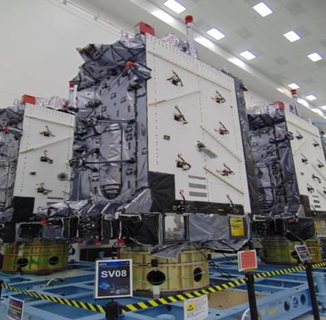
The U.S. Space Force’s Space Systems Command recently declared GPS III SV06, SV07 and SV08 satellites “Available for Launch.” Here, the space vehicles await official call up for launch in Lockheed Martin’s GPS III Processing Facility in Waterton, Colorado. (Photo: Lockheed Martin)
The U.S. Space Force’s Space Systems Command recently declared the eighth GPS III satellite as “Available for Launch.” This significant accomplishment officially marks the third space vehicle within the GPS III program to be declared available for launch in the past three months.
GPS III SV06, SV07, and SV08 are now awaiting official call up for launch in Lockheed Martin’s GPS III Processing Facility in Waterton, Colorado.
“SV06, SV07, and SV08 AFL milestones in just three months prove that GPS III production continues to benefit from efficiencies with each satellite delivery,” said Col. Edward Byrne, chief of SSC’s Space Production Corps’ Medium Earth Orbit Space Systems Division.
The first of the three recently completed satellites, SV06, is scheduled to launch in 2022 and will join the operational constellation of 31 GPS satellites.
GPS III satellites deliver enhanced performance and accuracy through a variety of improvements, including increased signal protection and improved accuracy. GPS III also expands the civilian L5 signal, dubbed the “safety-of-life” signal, currently broadcast by the 12 GPS IIF satellites, but not yet operational, and delivers a new L1C signal designed to grant interoperability to similar international space-based positioning, navigation, and timing systems around the world.
Space Systems Command, located at Los Angeles Air Force Base in El Segundo, California, is the U.S. Space Force’s Center of Excellence for acquiring and developing military space systems. SSC’s portfolio includes space launch, global navigation satellite systems, military satellite communications, a defense meteorological satellite control network, range systems, space-based infrared systems, and space domain awareness capabilities.
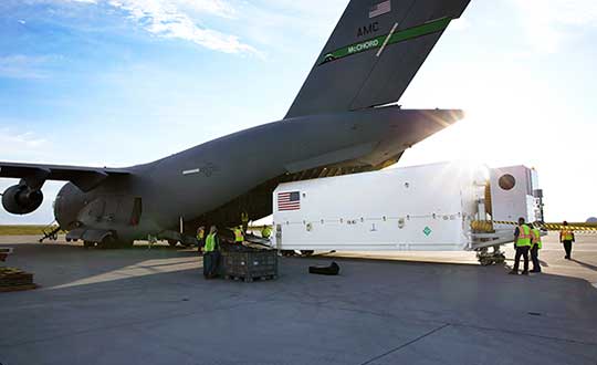
The U.S. Space Force Space and Missile Systems Center on July 14 delivered the fourth GPS III satellite to Cape Canaveral Air Force Station, Florida. The satellite is scheduled for launch on Sept. 30.
GPS III Space Vehicle (SV) 04 was safely transported from the Lockheed Martin facility in Waterton, Colorado to Space Coast Regional Airport in Titusville, Florida. The satellite was carried aboard a C-17 Globemaster III originating from Joint Base Lewis-McChord, Washington.
The fourth GPS III satellite arrived at Cape Canaveral July 14 for launch on Sept. 30. (Photo: USAF)
The delivery of GPS III SV04 starts the clock for final testing and checkout prior to launch. The satellite will be processed at the Astrotech Space Operations facility in Florida to ensure the full functionality of the satellite, prepare the satellite for propellant loading, and encapsulate the satellite in its protective fairing. At the completion of these activities, the satellite will be horizontally integrated with the SpaceX Falcon 9 launch vehicle.
“The shipment of the fourth GPS III satellite was successfully conducted just two weeks after the launch of our GPS III-SV03 satellite. This operation is a remarkable achievement and testament to the hard work of the entire GPS team members from all across the country,” said Col. Edward Byrne, SMC’s Medium Earth Orbit Space Systems Division chief. “The delivery of SV04 marks the start of our third GPS III launch campaign on a SpaceX Falcon 9 rocket and brings us another step closer in advancing the GPS constellation with more capable satellites.”
GPS III SV04 is slated to launch in September. Once on-orbit, it will join the operational constellation of 31 GPS satellites, delivering enhanced resiliency, better accuracy, and advanced anti-jam capabilities.
By Airman 1st Class Jonathan Whitely, 50th Space Wing Public Affairs
News from Schriever Air Force Base
The 2nd Space Operations Squadron performed the first station keeping maneuver on a GPS III satellite to Satellite Vehicle Number 75 on May 14 at the Schriever Air Force Base in Colorado.
The maneuver set a new standard for how GPS maneuvers should be conducted for the squadron that provides precision, navigation and timing signals to billions of users around the world.
A station keeping maneuver is performed to keep vehicles in their node (or parking spots in orbit) and involves burning the satellite’s thrusters and changing the vehicles speed at a particular point in its orbit. This causes the orbit to change, in turn, keeping the vehicle in the ideal position to provide coverage.
“All operational GPS vehicles are assigned nodes, when all nodes are filled with healthy vehicles there is good global GPS coverage,” said 1st Lt. Michael Gallagher, GPS subsystems analyst. “When new vehicles are launched they typically aren’t launched directly into their final node. This means that the 2 SOPS analysis flight must perform a re-phase maneuver to put a vehicle in its node.”
The maneuver required GPS III’s signal to be turned off. Turning off the navigation signal while performing the maneuver prevents users from receiving inaccuracies generated by a change in satellite velocity.
“This was a new process that we could learn from as it was the first station keeping [maneuver] performed for the newest generation of GPS satellites,” said Senior Airman Harrison Sherwood, 2 SOPS satellite systems operator, who sent the commands to the satellite during the maneuver. “[Since] this was the first [maneuver] of the newest generation satellites, it was a bit of a guinea pig for future maneuvers.”
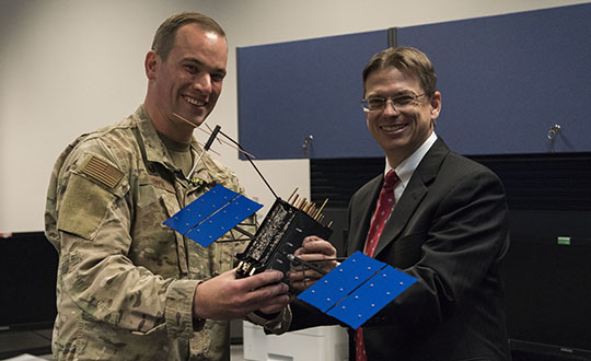
Johnathon Caldwell, Lockheed Martin Space vice president of navigation systems, right, presents Lt. Col. Stephen Toth, 2nd Space Operations Squadron commander, with a GPS III model satellite as a token of appreciation for the 2nd SOPS critical mission in space at Schriever Air Force Base, Colorado, July 29, 2019. The squadron performed its first station keeping maneuver on a GPS III satellite May 14, 2020, at Schriever AFB. (Photo: U.S. Air Force/1st Class Jonathan Whitely)
However, the unit was able to complete the maneuver flawlessly. The maneuver was completed in a special mission area and there were no changes to the normal operations floor.
“This maneuver had no effect on the rest of the [GPS satellite] constellation,” Gallagher said. “SVN-45 was in the node SVN-75 was being placed into, so there was no decrease in GPS signal quality as a result of this maneuver.”
This procedure was also the first of its kind to be performed with the 2nd SOPS Architecture Evolution Plan, which all active satellites in the program are operated. Since GPS III vehicles are fully integrated into the program with this maneuver, all maintenance is conducted through AEP.
“Station keeping maneuvers are essential to satellite operations and must be done for regular maintenance,” said 2nd Lt. Tyler Gorman, 2nd SOPS navigation payload engineer. “This activity helped validate a nominal maintenance activity for a new generation of vehicles.”
The unit plans to continue to use this new method and program for future GPS satellites that are being launched and need to be re-phased into their operation slots. The next satellite that will need a station maneuver performed is SVN-76, which is scheduled to launch in the next few months.
“GPS maintenance requires a coordinated effort to ensure our worldwide service is preserved,” Gorman said. “That means careful planning and execution from our analysts in 2 SOPS, our satellite system operator and the operational support from Lockheed Martin and the Aerospace Corporation.”
By Staff Sgt. Matthew Coleman-Foster, 50th Space Wing Public Affairs
The 2nd Space Operations Squadron set Satellite Vehicle Number-74 (SVN-74, the first GPS III satellite) as healthy and active to users on the 2nd SOPS operations floor.
Setting SVN-74 healthy and active means the satellite will be available for use by military and civilian GPS users around the world as part of the constellation currently maintained by the squadron. This makes the satellite the first iteration in the GPS III family to join the active constellation following its launch Dec. 23, 2018.
Capt. Ryan Thompson, 2nd SOPS assistant director of sustainment, said various training modules and upgrades were instrumental in making the satellite operational.
“In order to operate GPS III, we first had to install Architecture Evolution Plan 8.0,” he said. “This allowed our squadron to control the new satellite without a next generation operational control system. The 2nd SOPS training and evaluations flight was able to expeditiously give our operators top-up training that allowed them to become comfortable with the new satellite.”
The GPS III vehicle family provides new capabilities vital to ensuring the fidelity of the constellation and signal in the contested, degraded and operationally limited environments.
According to the Lockheed Martin press release, GPS III satellites have three times better accuracy and up to eight times improved anti-jamming capabilities than their predecessors, and a design life extending 25 percent longer than the newest GPS satellites on-orbit today. GPS III’s new civil signal will also make it the first GPS satellite to broadcast a compatible signal with other international global navigation satellite systems, like Galileo, improving connectivity for civilian users.
2nd SOPS is already preparing for the second GPS Block III vehicle in orbit, awaiting its day to become healthy and active.
“There are vehicles currently projected to be put into the constellation and then following this there will be the Block III-F follow-on vehicles,” said Capt. Kaoru Elliot, 2nd SOPS assistant director of operations. “With those vehicles in place, all of those capabilities will come into the next decade.”
A third vehicle for GPS III is scheduled for launch later this year.
“It [GPS Block III vehicle two] is being managed currently by Lockheed Martin,” Elliott said. “They are the ones actually getting the satellites up there and once it is up in orbit, they make sure everything is good before handing it over to us.”
The work within 2nd SOPS to ensure SVN-74 is healthy and active in the constellation shows their commitment to continue providing the gold standard of position, navigation, and timing to 4 billion users around the world.
Second Lt. Kelley McCaa, 2nd Space Operations Squadron satellite vehicle operator, and Airman 1st Class John Garcia, 2nd SOPS satellite systems operator, set satellite vehicle number-74, the first iteration of GPS Block III vehicles, as healthy and active to users Jan. 13, 2020, Schriever Air Force Base, Colorado,. Setting the vehicle healthy and active makes the satellite available for use by military and civilian GPS users around the world for agriculture, banking and navigation. (Photo: U.S. Air Force/Staff Sgt. Matthew Coleman-Foster)
The U.S. Air Force Second Space Operations Squadron (2 SOPS) has issued a statement that the first GPS III satellite is available for backup. While occupying the same plane as SV-68, the new satellite is broadcasting healthy, usable signals and is an active part of the constellation in the vicinity of slot F3 near SV-68.
On. Jan. 13, 2 SOPS issued an Initial Use (USABINIT) NANU for SVN-74, the first of the new generation of GPS-III satellites, according to Rick Hamilton, CGSIC executive secretariat.
SVN-74/PRN-04 was launched on Dec. 23, 2018. Now, having successfully undergone rigorous operational testing on orbit, the satellite has taken its place, backing up SVN-68/PRN-9 at F3 in the active GPS constellation.
NOTICE ADVISORY TO NAVSTAR USERS (NANU) 2020004
SUBJ: SVN74 (PRN04) USABLE JDAY 013/1734
NANU TYPE: USABINIT
NANU NUMBER: 2020004
NANU DTG: 131735Z JAN 2020
REFERENCE NANU: N/A
REF NANU DTG: N/A
SVN: 74
PRN: 04
START JDAY: 013
START TIME ZULU: 1734
START CALENDAR DATE: 13 JAN 2020
STOP JDAY: N/A
STOP TIME ZULU: N/A
STOP CALENDAR DATE: N/A
CONDITION: GPS SATELLITE SVN74 (PRN04) WAS USABLE AS OF JDAY 013
(13 JAN 2020) BEGINNING 1734 ZULU.
POC: CIVILIAN – NAVCEN AT 703-313-5900, HTTPS://WWW.NAVCEN.USCG.GOV
MILITARY – GPS OPERATIONS CENTER at HTTPS://GPS.AFSPC.AF.MIL/GPSOC, DSN 560-2541,
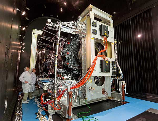
Thermal Vacuum testing verifies that a satellite can operate in space’s extreme environment. (Photo: Lockheed Martin)
With GPS III SV01 and SV02 now on orbit, GPS III satellites continue to roll off the production line at Lockheed Martin’s GPS III Processing Facility near Denver.
Johnathon Caldwell, Lockheed Martin Space’s vice president for navigation systems, provided GPS World with an update to the entire GPS III family.
SV01. The first GPS III satellite is in a holding state pending readiness by 2SOPS [the Second Space Operations Squadron] to take the vehicle onto the system for operational checkout, a transfer expected to take place later this year, Caldwell explained. The satellite completed on-orbit testing in July.
“We’re in the process of getting the 2SOPS crews trained up to operate a GPS III vehicle,” Caldwell said. “By the end of this year, they will be able to take [SV01] into the constellation and start flying it as a live, set-healthy vehicle.”
SV02. Launched Aug. 22, SV02 is following in the footsteps of its older sibling, with a quiet checkout and no major findings. Like SV01, once it completes testing, it will stay in temporary holding until 2SOPS is ready to bring it into the constellation.
SV03. On May 27, the Air Force declared SV03 available for launch. It is now in final preparations for shipment, with an expected launch date in January 2020 aboard a Falcon 9 rocket.
SV04. The Air force declared SV04 available for launch; it is now in storage awaiting a launch date.
SV05. The fifth satellite is wrapping up environmental tests. Lockheed Martin anticipates that it will be available for launch early next year.
SV06. The satellite has been moved into the thermal vacuum testing chamber and begun a rigorous testing campaign before it meets the harsh environment of space.
SV07, SV08 and SV09 are on the assembly line.
GPS IIIF Satellites. In 2018, the Air Force selected Lockheed Martin to build up to 22 GPS IIIFs, adding new features and resiliency to the original GPS III satellite design. The company has been on the path to meet the critical design review for the GPS IIIF spacecraft, which is due to take place next spring.
GPS OCX will maneuver satellite into final orbit over 10 days
The U.S. Air Force used Raytheon Company’s GPS Next-Generation Operational Control System, known as GPS OCX, to support the launch of its second GPS III satellite into space. The ground system will now spend 10 days maneuvering the satellite into its final orbit, demonstrating GPS OCX’s ability to simultaneously support multiple GPS III spacecraft on-orbit throughout the checkout and calibration process.
Raytheon’s GPS OCX has obtained the highest level of cybersecurity protections of any Department of Defense space system.
“GPS OCX performed extremely well during the first launch and has exceeded performance requirements in the months since,” said Dave Wajsgras, president of Raytheon Intelligence, Information and Services. “The team was well-prepared for this launch, and we’re confident the system’s performance will continue to be positive.”
GPS OCX, the enhanced ground control segment of America’s GPS system, has achieved the highest level of cybersecurity protections of any Department of Defense space system. Its open architecture design allows it to integrate advanced protections as they become available, and the system’s industry-leading cyber protections are why it will be used to support all future GPS III launches and GPS constellation operations upon operational acceptance.
Earlier this year, the team completed final qualification testing of the system’s modernized monitor station receivers, which can receive and decrypt all GPS III military and civil signals. Global installation of the receivers starts next month and keeps the program on track for full system delivery by the program’s June 2021 contractual deadline.
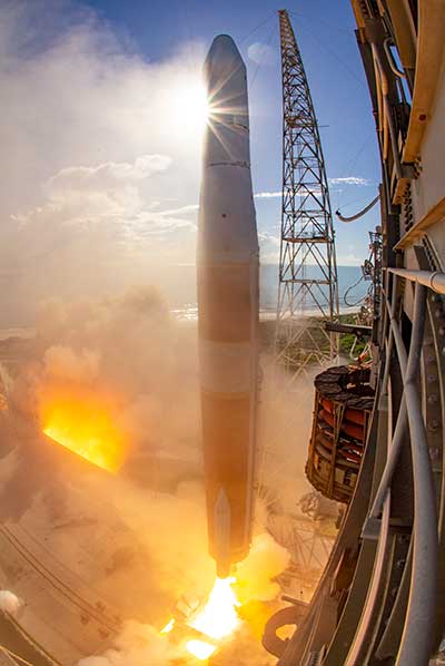
In addition to GPS OCX’s role, RGNext, a joint venture between Raytheon and General Dynamics Information Technology, provided operational launch support to ensure the safe launch of the United Launch Alliance’s Delta-IV rocket that was carrying the GPS III satellite. RGNext operates the launch range on behalf of the U.S. Air Force, providing maintenance, range safety, weather monitoring, communication and surveillance support for all launches conducted by defense, civil and commercial companies at the range. To access our press kit, which includes photos, videos and an animation, please visit us here. To learn more about the program’s progress and additional capabilities, visit us here.
A ULA Delta IV rocket carrying GPS III SV02 lifts off from Space Launch Complex-37 on Aug. 22. (Photo: ULA)
The U.S. Air Force’s second next-generation GPS III satellite, built by Lockheed Martin, is responding to commands, under control and now using its own internal propulsion system to get to orbit following its successful Aug. 22 launch.
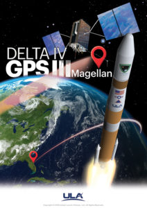
At 11:01 a.m. ET, Air Force and Lockheed Martin engineers at Lockheed Martin’s Launch & Checkout Facility near Denver declared they had full control of GPS III Space Vehicle 02 shortly after the satellite’s separation from its United Launch Alliance (ULA) Delta IV rocket booster. The satellite, nicknamed “Magellan” by the Air Force, began its rocket ride to space with a 09:06 a.m. ET launch from Cape Canaveral Air Force Station.
GPS III SV02 is now climbing towards its operational orbit about 12,550 miles above the earth under the power of its own Liquid Apogee engines. Engineers at Lockheed Martin Space’s Waterton, Colorado facility are commanding the satellite using elements of the GPS Next Generation Operational Control System (OCX) Block 0.
“GPS III SV02 is receiving and responding to commands just as planned. In the days ahead, we’ll finish orbit raising to our operational slot and then send the satellite commands telling it to deploy its solar arrays and antennas,” said Johnathon Caldwell, Lockheed Martin Space’s Vice President for Navigation Systems. “Once we are set up, we’ll begin on-orbit checkout and tests, including extensive signals testing with our advanced navigation payload.”
The payload is provided by L3Harris. The first GPS III satellite launched in December 2018 and its navigation payload has performed beyond expectations on-orbit during pre-operational testing, according to L3Harris.
GPS III SV02 is the second GPS III satellite designed and built by Lockheed Martin to help the Air Force modernize today’s Global Positioning System (GPS) constellation with new technology and capabilities. GPS III satellites provide 3x greater accuracy and up to 8x improved anti-jamming capabilities. GPS III also provides a new L1C civil signal, compatible with other international global navigation satellite systems, like Europe’s Galileo.
The First GPS III Satellite Completes On-Orbit Testing
Image: ULA
GPS III SV02 will be the second GPS III satellite in orbit and the second GPS III satellite now being commanded from Lockheed Martin Space’s facility.
On Dec. 23, 2018, the Air Force launched the first GPS III satellite. Nicknamed “Vespucci,” GPS III SV01 underwent months of checkout and thorough testing of its advanced, new navigation payload provided by Harris Corporation.
“GPS III SV01’s performance exceeded expectations during testing,” Caldwell said. “On July 12, we officially completed all On Orbit Check Out & Test activities. We are excited to see this satellite move to the next phase and perform in an operational environment.”
That’s expected to happen later this year once the first satellite is handed over to the Air Force.
Thinking Ahead From the Ground Up
In preparation for this handover, in 2016, the Air Force awarded Lockheed Martin the GPS III Contingency Operations (COps) contract to upgrade its current GPS ground control system – the Operational Control Segment (OCS) – to be able to fly today’s 31-satellite constellation, as well as the new, more-powerful GPS III satellites, until OCX Block 1, still in development, is delivered.
Lockheed Martin delivered the GPS III COps software upgrade in May and it is currently undergoing preparations for installation.
COps is the latest GPS ground control upgrade project Lockheed Martin has had since it began sustaining the OCS in 2013. In November 2018, the company completed the AEP 7.5 upgrade — the largest architectural change in the system’s history — replacing significant code, hardware and software to improve the system’s cybersecurity capabilities and positioning the Air Force to better operate in contested, degraded and operationally limited environments.
In December 2018, the Air Force awarded Lockheed Martin the GPS Control Segment Sustainment II (GCS II) contract to continue to further modernize and sustain the OCS through 2025.
In 2020, the OCS is expected to receive the M-Code Early Use (MCEU) upgrade, which will allow control of M-Code, an advanced, new signal designed to improve anti-jamming and anti-spoofing, as well as to increase secure access to military GPS signals for U.S. and allied armed forces.
With GPS III SV01 and SV02 now on orbit, GPS III satellites continue to roll off the production line at Lockheed Martin’s advanced $128-million GPS III Processing Facility near Denver. On May 27, the Air Force declared the GPS III SV03 Available for Launch (AFL) and had the company place it into storage waiting for a launch date. GPS III SV04-08 are now in various stages of assembly and test.
In all, Lockheed Martin is under contract to build up to 32 next-generation GPS III/IIIF satellites for the Air Force. Additional IIIF capabilities will begin being added at the 11th satellite. These will include a fully digital navigation payload, a Regional Military Protection capability, an accuracy-enhancing laser retroreflector array, and a Search & Rescue payload.
The Harris-supplied navigation payload before integration into the second GPS III SV. (Photo: L3Harris)
As the U.S. Air Force prepares to launch its second next-generation GPS III satellite, L3Harris Technologies delivered its eighth navigation payload to GPS III satellite prime contractor Lockheed Martin.
The first GPS III satellite launched in December 2018 and its navigation payload has performed beyond expectations on-orbit during pre-operational testing, L3Harris said in a press release.
In May, the Air Force declared the third GPS III satellite Available for Launch, pending a launch date. L3Harris payloads are also already fully integrated in the GPS III 4-6 space vehicles currently in production and testing at Lockheed Martin.
The GPS III navigation payload features a mission data unit (MDU) with a unique 70-percent digital design that links atomic clocks, radiation-hardened processors and powerful transmitters — enabling signals three times more accurate than those on current GPS satellites. The payload also boosts signal power, which increases jamming resistance by eight times and helps extend the satellite’s lifespan.
In 2017, L3Harris announced that it completed development of an even more-powerful, fully digital MDU for the Air Force’s GPS III Follow On (GPS IIIF) program. The new GPS IIIF payload design will further enhance the satellite’s capabilities and performance.
In September 2018, the U.S. Air Force selected Lockheed Martin for a fixed-price-type production contract for up to 22 GPS IIIF satellites. L3Harris is Lockheed Martin’s navigation signal partner for GPS IIIF satellites, and in January received a $243 million award to provide the navigation signals for the first two GPS IIIF satellites, space vehicles 11 and 12.
L3Harris’ expertise in creating and sending GPS signals extends back to the mid-1970s — providing navigation technology for every U.S. GPS satellite ever launched. While the Air Force originally developed GPS for warfighters, millions of people around the world and billions of dollars of commerce now depend on the accurate, reliable signal created and sent by L3Harris navigation technology.
The U.S. Air Force’s second new GPS III satellite, bringing higher-power, more accurate and harder-to-jam signals to the GPS constellation, has arrived in Florida for launch.
On March 18, Lockheed Martin shipped the Air Force’s second GPS III space vehicle (GPS III SV02) to Cape Canaveral for an expected July launch.
Designed and built at Lockheed Martin’s GPS III Processing Facility near Denver, the satellite traveled from Buckley Air Force Base, Colorado, to the Cape on a massive Air Force C-17 aircraft. The Air Force nicknamed the GPS III SV02 “Magellan” after Portuguese explorer Ferdinand Magellan.
GPS III is the most powerful and resilient GPS satellite ever put on orbit. Developed with an entirely new design, for U.S. and allied forces, it will have three times greater accuracy and up to eight times improved anti-jamming capabilities over the previous GPS II satellite design block, which makes up today’s GPS constellation.
GPS III also will be the first GPS satellite to broadcast the new L1C civil signal. Shared by other international global navigation satellite systems, like Galileo, the L1C signal will improve future connectivity worldwide for commercial and civilian users.
The Air Force began modernizing the GPS constellation with new technology and capabilities with the December 23, 2018 launch of its first GPS III satellite. GPS III SV01 is now receiving and responding to commands from Lockheed Martin’s Launch and Checkout Center at the company’s Denver facility.
Lockheed Martin shipped the U.S. Air Force’s first GPS III to Cape Canaveral, Florida ahead of its expected July launch. (Photo: Lockheed Martin}
“After orbit raising and antenna deployments, we switched on GPS III SV01’s powerful signal-generating navigation payload and on Jan. 8 began broadcasting signals,” Johnathon Caldwell, Lockheed Martin’s Vice President for Navigation Systems. “Our on orbit testing continues, but the navigation payload’s capabilities have exceeded expectations and the satellite is operating completely healthy.”
GPS III SV02 is the second of ten new GPS III satellites under contract and in full production at Lockheed Martin. GPS III SV03-08 are now in various stages of assembly and test. The Air Force declared the second GPS III “Available for Launch” in August and, in November, called GPS III SV02 up for its 2019 launch.
In September 2018, the Air Force selected Lockheed Martin for the GPS III Follow On (GPS IIIF) program, an estimated $7.2 billion opportunity to build up to 22 additional GPS IIIF satellites with additional capabilities.
GPS IIIF builds off Lockheed Martin’s existing modular GPS III, which was designed to evolve with new technology and changing mission needs. On September 26, the Air Force awarded Lockheed Martin a $1.4 billion contract for support to start up the program and to contract the 11th and 12th GPS III satellite.
Once declared operational, GPS III SV01 and SV02 are expected to take their place in today’s 31 satellite strong GPS constellation, which provides positioning, navigation and timing services to more than four billion civil, commercial and military users.
Less than three weeks after its launch, the first GPS III satellite, SVN74, started transmitting navigation signals. SVN74 uses the pseudorandom noise (PRN) code number G04 previously used by the almost 25-year-old Block IIA satellite SVN36. The L1 C/A, L1 P(Y), and L2 P(Y) signals of SVN74 have been tracked since Jan. 9 at 00:01 UTC. Activation of the L2C and L5 signals followed on the same day at 19:43 UTC. Transmission of the legacy navigation message (LNAV) started Jan. 9, but the satellite is still marked unhealthy for ongoing on-orbit check out and testing.
Also, SVN74 is the first GPS satellite to transmit a new civil signal on the L1 frequency (1575.42 MHz), namely L1C, which was initially activated on the same day as the other SVN74 signals. Incidentally, the L1C signal was already being transmitted by the four satellites of the Japanese Quasi-Zenith Satellite System (QZSS).
Compared to the L1 C/A PRN codes, the L1C codes are 10 times longer (10,230 chips), reducing interference when multiple satellites are tracked by a receiver on the same frequency. Like L2C and L5, the L1C signal consists of a dataless pilot component and the data component with navigation data. Dataless signals enable more robust tracking under difficult conditions. For the L1C signal, 75 percent of its power is put into the pilot component.
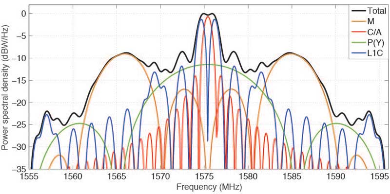
The theoretical spectra of the four signals transmitted on L1 by SVN74, namely the civil C/A-code and L1C, as well as the military P(Y)-code and M-code, are shown in FIGURE 1 along with the the total (summed) spectrum.
Figure 1. Theoretical spectra of the four signals transmitted by a GPS III satellite in the L1 frequency band. (Image: Authors)
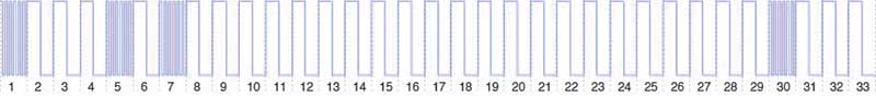
BOC. To achieve compatibility with the L1 C/A-code signal at the same center frequency, a binary offset carrier (BOC) modulation is used for spectral separation of L1C from L1 C/A. A BOC(n,m) signal is characterized by the fundamental frequency of the square wave subcarrier expressed in multiples n of the basic frequency of 1.023 MHz and the chipping rate expressed in multiples m of 1.023 megachips per second. A BOC(1,1) modulation is used for the L1C data component. For the pilot component, a time-multiplexed binary offset carrier (TMBOC) is used. The spreading waveform, with a length of 33 symbols, consists of four BOC(6,1) and 29 BOC(1,1) symbols as illustrated in FIGURE 2 resulting in a TMBOC(6,1,4/33) signal. The additional BOC(6,1) component allows for improved multipath mitigation.
Figure 2. Spreading symbols for the L1C pilot component: time-multiplexed BOC consisting of BOC(6,1) for the 1st, 5th, 7th and 30th symbols and BOC(1,1) for the other symbols. (Image: Authors)
Similar to GPS L1C, the European Galileo and the Chinese BeiDou-3 systems employ multiplexed BOC signals with BOC(1,1) and BOC(6,1) components in the L1 frequency band. A composite BOC (CBOC) modulation has been adopted for the Galileo E1 open service signal, which uses a weighted sum of the BOC(1,1) and BOC(6,1) components in both the data and the pilot channels. For the BeiDou B1C signal, BOC(1,1) is used for the data channel, while a quadrature multiplexed BOC modulation, QMBOC(6,1,4/33), with BOC(1,1) and BOC(6,1) subcarriers in phase quadrature, is used for the pilot channel.
Interoperability. The new civil L1 signals of GPS, Galileo and BeiDou show a high level of commonality and are specifically designed for full interoperability. This means that receivers can easily track signals of all three constellations and use the measurements to compute a combined multi-GNSS position solution. Aside from the similar signal modulations, the interoperability is further supported by the transmission of inter-system timing biases (such as the GPS-Galileo Time Offset) in the navigation messages.
The binary phase shift keying (BPSK) modulation of the C/A-code with a 1.023-MHz chipping rate introduces a main lobe at the center frequency of 1575.42 MHz and numerous side lobes with decreasing amplitude. The 10.23-MHz BPSK signal of the P(Y)-code is visible in Figure 1 as a broad peak at the center frequency and first side lobes at about 1560 and 1590 MHz. The M-code is characterized by its main lobes ±10.23 MHz from the center frequency due to its BOC(10,5) modulation. Finally, the L1C signal can be recognized as two narrow peaks separated by ±1.023 MHz from the L1 center frequency related to the BOC(1,1) modulation and two peaks at ±6.138 MHz related to the BOC(6,1) modulation. Side lobes of the BOC(1,1) signal are visible next to the main lobes at integer multiples of 2 × 1.023 MHz.
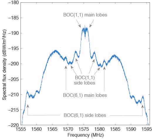
Observations. The German Aerospace Center (DLR) operates a 30-meter dish antenna at its ground station in Weilheim, near Munich, Germany. FIGURE 3 shows the L1 spectrum of SVN74 measured on January 15, 2019. One can clearly see the L1C BOC(1,1) main lobes at 1574 and 1576 MHz as well as the BOC(6,1) main lobes at 1569 and 1581 MHz. Selected side lobes are also indicated.
Figure 3. SVN74 L1 spectral flux density measured with the Weilheim 30-meter antenna on January 15, 2019, at 08:04 UTC. Selected features of the L1C signal are indicated by arrows. (Image: Authors)
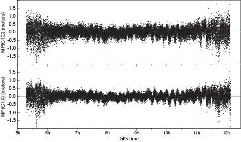
Initially, none of the International GNSS Service network receivers could track the L1C live signal of SVN74, but dedicated firmware versions supporting L1C tracking were soon made available by selected manufacturers. FIGURE 4 shows the multipath linear combination for the L1 C/A-code and the L1C signal tracked with a Javad TRE-G3TH receiver. Reduced measurement noise (multipath plus receiver measurement noise) of the L1C signal can be seen over all elevation angles ranging from about 3 to 83 degrees. (Tracking of the pass began at 4.3 degrees and ended at 3.0 degrees.)
Figure 4, Multipath linear combination (L1 pseudorange and L1 and L2 carrier phase) of the SVN74 L1 C/A-code (top) and L1C signal (bottom) from 1-Hz data of February 3, 2019, tracked with a Javad TRE-G3TH receiver at the Geodetic Observatory Wettzell. (Image: Authors)
The overall root-mean-square noise of the SVN74 pass shown in Figure 4 is 32 centimeters for the L1 C/A-code signal and 24 centimeters for L1C, that is, a reduction of 25 percent for L1C. Compared to the BPSK modulation of the legacy C/A-code signal, the increased steepness of the TMBOC correlation function offers lower measurement noise for the L1C tracking. In addition, the sensitivity to multipath is reduced.
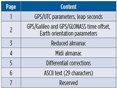
CNAV-2. Together with L1C, the second version of the civil navigation message, namely CNAV-2, is being transmitted. CNAV-2 is composed of three subframes: subframe 1 contains information about the current epoch. Subframe 2 comprises clock and ephemeris data including inter-signal corrections (ISCs). ISCs provide clock corrections for single-frequency users and dual-frequency users utilizing signals other than L1 P(Y) and L2 P(Y). Whereas the essential broadcast ephemeris data in subframe 2 repeat continuously over the validity period of typically two hours, subframe 3 contains pages with alternating content as listed in TABLE 1 (page 41).
Table 1 Currently defined pages of the CNAV-2 subframe 3.
Despite a different message layout, most CNAV-2 parameters and their values match those transmitted in the CNAV message of the L2C and L5 signals. Additional parameters comprise the ISCs for the L1C signal. Compared to the LNAV legacy navigation message, CNAV and CNAV-2 utilize an extended set of ephemeris parameters that allow for a smoother orbit representation compared to LNAV. Multi-GNSS applications benefit from the GPS/GNSS time offset (GGTO) parameters included in page 2. In the same page, Earth orientation parameters are provided that are relevant for users of an inertial frame, such as for spaceborne navigation. The CNAV-2 repeat cycle of 18 seconds allows for a faster access to broadcast ephemerides included in subframe 2 compared to LNAV. Compared to CNAV, CNAV-2 furthermore provides a more sophisticated error detection and correction scheme.
As of the beginning of February 2019, only pages 1, 2 and 4 of CNAV-2 subframe 3 are being used. Within a cycle of 144 seconds, page 1, page 2 and six sets of page 4 midi almanac data (each for one individual satellite) are transmitted. The full almanac for 32 satellites is thus transferred in an average of about 13 minutes. The content in these subframes corresponds to that in L2 and L5 CNAV messages. Updates of CNAV-2 are performed in two-hour intervals starting at 01:30. This is the same update scheme as for CNAV but different from LNAV where the two-hour intervals start at 00:00.
Note that some time will pass before enough GPS III satellites are transmitting so that users can fully enjoy the benefits of the new L1C signal.
MANUFACTURERS
Spectral measurements at the Weilheim 30-meter antenna were made with a Rohde & Schwarz FSQ26 vector signal analyzer. Receiver measurements have been collected with a JAVAD GNSS TRE-G3TH receiver running an L1C-capable firmware version.
PETER STEIGENBERGER and OLIVER MONTENBRUCK are scientists at the German Space Operations Center of the German Aerospace Center (DLR). STEFFEN THOELERT is an electrical engineer at DLR’s Institute of Communications and Navigation. RICHARD B. LANGLEY is a professor at the University of New Brunswick and editor of the Innovation column for GPS World magazine.