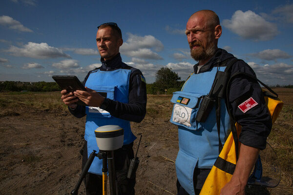
Trimble has partnered with HALO Trust, a landmine-clearing non-profit organization, to help expand its demining operations across Ukraine.
The grant from the Trimble Foundation Fund will focus on strengthening the HALO Trust’s ability to locate and remove landmines, unexploded ordnance and other explosive hazards from civilian areas to create safer communities. In addition, it will allow HALO to support the Ukrainian national authorities in planning and coordinating landmine clearance activities by streamlining the mapping and data flow from the operational teams in the field to the national database.
The Russian invasion of Ukraine has left areas of the country contaminated with landmines, unexploded ordnance and improvised explosive devices. These hazards block access to farmland, impede reconstruction efforts, prevent displaced persons from returning to their homes and continue to hinder the safety of Ukrainian civilians. The Ukrainian government estimates that 174,000km2 of the country’s land may be contaminated.
More than a thousand HALO staff members are active daily, both to clear explosives in critical priority areas and to recruit and train hundreds of new staff members to help keep communities safe from dangerous weapons left behind.
Surveying and mapping technology has played a significant role in the success of HALO’s operations around the world, including in Ukraine. Over the last six years, Trimble R1 and Trimble R2 GNSS receivers along with Esri ArcGIS Survey123 software have been used by HALO to identify and clear landmines.
Trimble’s Geospatial and Positioning Services businesses provided HALO with a new deployment of 255 high-precision Trimble DA2 GNSS receivers with Trimble Catalyst corrections service, allowing HALO to modernize and transform its landmine clearance operations by providing improved accuracy for more detailed maps, streamlined data flows and increased operational efficiency and safety.
The C-130 Hercules aircraft is used to rapidly drop cargo to provide relief after disasters or troops into battle zones. (Image: USAF Devin Doskey- 341st Missile Wing Public Affairs)
GPS Innovation Alliance (GPSIA) member companies are leaders in technology, transforming the digital and physical world around us. With countless essential applications, GPSIA members improve the industries that feed, build, move and connect communities across the globe. In times of need, the GPS industry is proud to rise to the occasion, whether through agriculture technologies, surveying equipment, navigation systems, essential communications tools, or humanitarian relief efforts. Simply put, GPSIA members are continually investing in lifesaving services at home and abroad.
Take, for example, the urgent need for humanitarian relief created by the ongoing war in Ukraine. Trimble has stood united to support the many affected and displaced Ukrainians; in addition to contributing through the Trimble Foundation to relief efforts in Ukraine and neighboring countries, Trimble also has provided GPS signal corrections to Ukrainian farmers at no cost, supplied 3D scanners for surveying damaged buildings, and worked closely with The HALO Trust to support demining activities in Ukraine by providing funding and commercial surveying systems to assist in precision mapping of landmines and unexploded ordnances.
Lockheed Martin’s C-130 Hercules aircraft has assisted essential humanitarian relief across the globe. Since its inaugural flight in 1954, this aircraft has enabled aid delivery, natural disaster relief, medevac services, search and rescue and more. Now equipped with GPS technology, the C-130 fleet has provided aid across the globe for decades — with L3Harris’ missionization solutions often at work to maximize the C-130’s utility. Similarly, Collins Aerospace’s state-of-the-art navigational technology has provided essential support to U.S. Coast Guard helicopters, with avionics upgrades that help pilots save time in emergencies and enhance situational awareness.
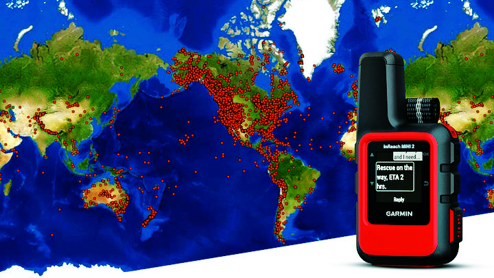
Garmin inReach devices can send and receive messages, navigate routes, track and share journeys and can trigger an SOS if needed. (Image: Garmin)
More broadly, Garmin inReach satellite communication devices have helped more than 10,000 individuals access emergency services, providing critical communications in natural disasters and humanitarian emergencies. In 2022, a powerful underwater volcanic eruption and tsunami devastated the island nation of Tonga, severing traditional communications channels for several weeks. Roy Neyman, a sailor equipped with this Garmin device, set up a communication center at a local restaurant to allow other residents to reach family and friends. Over two weeks, Tonga residents sent about 1,600 messages to loved ones around the world, offering peace of mind in the face of unthinkable destruction. Similarly, Apple recently launched an “Emergency SOS” service, which led to one of the first successful rescue efforts of two people who had driven off a highway in the Angeles National Forest.
CalAmp’s Fusion routers enable lifesaving emergency services to more than 400,000 residents in Oakland, California. Equipped with GPS, LTE and WiFi technology, these routers help Oakland Fire first responders quickly locate emergencies and access additional resources, such as building layouts or fire records, to provide the best possible emergency response. CalAmp’s technology provides an essential service to residents of Oakland and can be adapted to meet the changing needs of the community.
As the world of agriculture has come to depend on GPS technology, John Deere’s GPS-based agricultural services have helped farmers become more efficient. In turn, this has allowed farmers to harvest more crops for the masses and meet the ever-growing demand for food. With the annual growth in food demand estimated to be 1.4% over the next decade, John Deere’s critical investment in food banks in Mexico and training for farmers in Africa will help to ensure that all communities are able to access the food they need.
Across industries and government, GPS technology makes for a safer, more connected world. GPSIA is proud of its members’ dedication to global humanitarian efforts as well as critical services close to home. By constantly innovating, GPSIA member companies are creating technologies that provide critical services for everyday emergencies, natural disasters, and humanitarian crises across the globe.
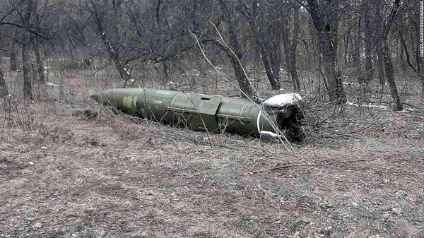
A Russian short-range ballistic missile, believed to be an unexploded Iskander missile, was found near Kramatorsk, Ukraine, in this photo released March 9 by Ukrainian authorities. (Photo: National Guard of Ukraine handout via Reuters)
As a geopolitical and devastating humanitarian crisis unfolds in Ukraine, the HALO Trust is partnering with Esri to map unexploded ordnance as part of an immediate humanitarian response.
More than 10 million Ukrainians have been displaced by the war and many are forced to move across a landscape littered with unexploded rockets, bombs and landmines.
In response, Esri has committed its cutting-edge geographic information system (GIS) software resources, expertise and staffing in support of HALO’s mission in Ukraine.
The organizations’ collaboration will allow them to map areas contaminated with explosives so HALO can remove the hazards when conditions allow. This will provide safe land to house displaced families and clear routes for humanitarian aid to reach those in desperate need.
HALO is already using GIS to map the heaviest conflict zones, and the partnership with HALO will support planning for future clearance operations.
As experts in their field, HALO is the world’s largest humanitarian landmine clearance and weapons disposal organization, clearing more than 13.9 million landmines and unexploded ordinance across 28 countries torn apart by conflict.
In addition to technical expertise, HALO staff provide safety education for those in contaminated areas to avoid life-changing injuries and death, emergency medical aid, and humanitarian support for displaced persons as they face conflict, and in many cases are forced to flee their homes.
Esri has collaborated with HALO since 2008 helping to map war-ravaged regions where specific locational awareness of landmines and other hazards is necessary to protect the lives of people in those areas.