Armando Mendoza and Dave Huntingford, product managers for CSR, demonstrate the company’s SiRFstar location technology while at the 2014 ION GNSS+ Conference September 9-12 in Tampa, Florida.
Tag: ION GNSS 2014
-

Which Industry Will Be the Largest Consumer of RTK Technology?
In September, I attended the Institute of Navigation (ION) GNSS+ conference in Tampa, Florida.

Downtown Tampa, location of the 2014 ION GNSS+. Photo: GPS World The ION GNSS+ conference is a gathering where many of the GNSS scientists from around the world come to share their successes, trials and tribulations. It gives one a view into the future of where GNSS positioning might go. Granted, most of the ideas and concepts presented won’t ever be introduced in a commercial product, but it’s great to see that engineers are pushing the technology envelope to see how much they can squeeze from receivers.
As I was perusing the ION GNSS+ conference agenda, I was looking for presentations and other subject matter relevant to RTK GNSS technology. (Yes, I’ve been obsessed with low-cost RTK receivers this past year, if you haven’t been following).
I’d like to tell you about two presentations I attended. The first was sort of unexpected, and the second was every bit of what I hoped it would be.
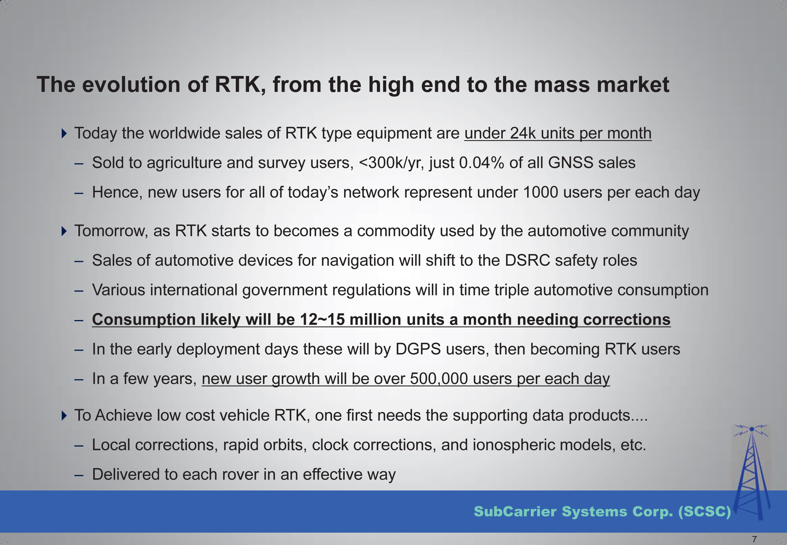
The first was a presentation by SubCarrier Systems Corp (SCSC), a small consultancy focused on ITS (Intelligent Transportation Systems) technology. It just so happens, according to David Kelley of SCSC, that RTK receivers and RTK networks will play a critical role in the future of ITS and, as a result, help drive down the cost of RTK technology.
How is RTK relevant to ITS?
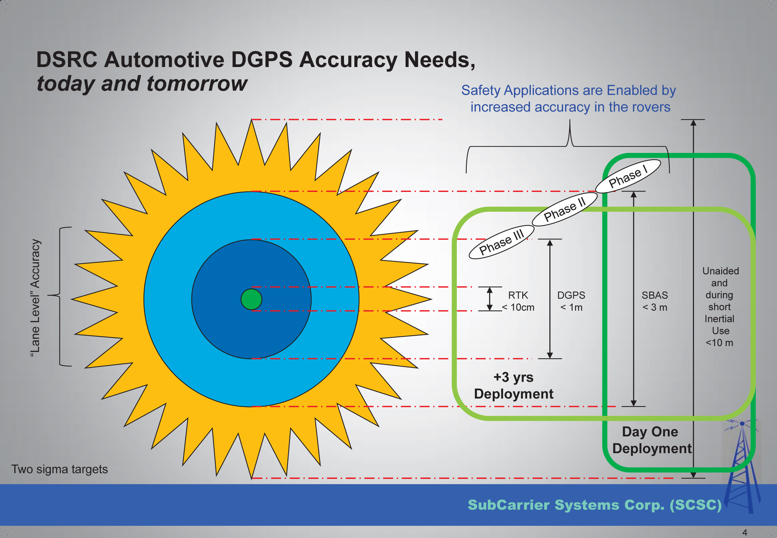
In ITS, I’ve been told there are three levels of accuracy that drive particular ITS applications. The accuracy terms are expressed in transportation terms:
- Which Road?, Which Lane? and Where in the Lane?
Translated into GPS accuracy terms:
- Which Road? = Autonomous GPS — 5-meter accuracy
- Which Lane? = WAAS (or SBAS)-corrected GPS — 1-meter accuracy
- Where in the Lane? = RTK — 2-cm accuracy

Mr. Kelley further presented that transportation applications of RTK technology will drive mass-market adoption (commoditization) of RTK technology and into the millions of units sold.

Lastly, he discussed the strain that such massive deployment of RTK technology in transportation might place on existing RTK networks run by state agencies.

To view the entire presentation from Mr. Kelley, you can click here.
The second RTK-centric presentation I attended at the conference was a moderated discussion panel entitled “High-Precision GNSS — What Will It Look Like in 2020?”
If you’ve followed my articles over the past couple of years, you have to know I was looking forward to attending this discussion panel with great anticipation.

Discussion Panel Members:
High Precision GNSS – What will it Look Like in 2020? Photo: GPS WorldThe discussion panel members were (from right to left):
- Gian Gherardo Calini – European GNSS Agency
- Ivan Di Federico, Chief Strategy Office and EVP, Topcon Positioning
- Bernhard Richter, GNSS Business Director, Leica Geosystems, Switzerland
- Elmar H. Lenz, General Manager – Geospatial GNSS, Geospatial Division, Trimble Navigation Ltd.
- Jan Van Hees, Director of Business Development, Altus Positioning Systems
- Shaowei Han, Co-founder and CEO/President, Wuhan Navigation and LBS, Inc., China
The discussion began with a short presentation by Gavin Schrock, who, among other things, administers the Washington State Reference Network, a state-wide RTK network, to frame the discussion.
Next, each panel member commented on the presentation and provided some of their own thoughts. The thoughts by the mainstream manufacturers were largely what you’d expect, since they do not look forward to the day that RTK technology becomes a commodity.
I’ll cut to the chase and just say that the gentleman from China, Dr. Han, stunned the audience with his claim that RTK GNSS chips will eventually be sold for $20 each. OK, to be fair, he also said RTK GNSS modules (an RTK GNSS chip on a circuit board with supporting components) will sell for $100. At first, these numbers seemed somewhat shocking to the audience, and one might dismiss it as being a speculative pipe-dream to disrupt the current RTK receiver competitive landscape. But then, when questioned, he dropped the reality bomb with a sort of puzzling look at the audience, being a little surprised why they didn’t understand. He said, and I’m paraphrasing, that $100 for an RTK module in 2020 doesn’t seem to be a stretch at all if you consider that RTK GNSS modules in China are selling for only $400 today. BOOM! He dropped the hammer. I admit, the $400 number even surprised me a bit. I thought it was more like $800.
The reason for the low price is the number of RTK GNSS receivers sold in China is more than 100,000 per year now, and growing. That’s more than the rest of the world combined. What’s driving the demand for RTK GNSS receivers? You guessed it — transportation. While the mainstream RTK GNSS manufacturers are still talking about RTK GNSS technology for niche markets like surveying, engineering, GIS, construction, and agriculture, Dr. Han was talking about RTK GNSS technology being used by everyday consumers for everyday activities. He’s talking about the commoditization of RTK GNSS, and he’s right. The only question that remains is how soon it will arrive.
Thanks, and see you next month.
Following me on Twitter at https://twitter.com/GPSGIS_Eric
-
ION GNSS+ 2014: Spirent Communications
John Pottle from Spirent Communications details the company’s GSS9000 RF constellation simulator at the 2014 ION GNSS+ Conference September 9-12 in Tampa, Florida. Spirent Federal’s GSS9000 RF constellation simulator has been reviewed and granted security approval by the Global Positioning Systems Directorate.
-
The Business & Product Showcase — October 2014
The Business section from the October 2014 issue. Download the PDF here.
Includes: Septentrio Consolidates Sales for Americas with Altus; NovAtel Adds IMU to SPAN Line; IFEN Launches SX3 Software Receiver; ION Awards Given to Misra, Banville; CTIA Super Mobility Week; ION GNSS+ Conference
PLUS: ION GNSS+ Product Showcase
-
GPS World Leadership Dinner and Race to Market
Invited guests at the annual GPS World Leadership Dinner, a special event held September 11 during ION GNSS+ in Tampa, Florida, heard perspectives from sponsors Lockheed Martin, Exelis, Raytheon, and Braxton Technologies, as well as visions of GNSS progress from our four award winners.
Leadership Awards were given to Javier Benedicto Ruiz, Galileo Project Manager, European Space Agency (Satellites category); Sherman Lo, senior research engineer and associate investigator (APNT), Stanford University (Signals category); Eric Gakstatter, contributing editor for survey and GIS, GPS World (Services category); and Oliver Montenbruck, head of GNSS Technology and Navigation Group, DLR, German Space Operations Center (Products category).
Over dessert, each table rose to the challenge of creating a phenomenal GNSS product or service and then competed in car races at the track.
More coverage of the awards will appear in the December issue.

The Dinner and Awards Ceremony was attended by 150 VIPs from industry, government, and research: top-level GNSS networking. 
The 2014 leadership awards, determined by a poll of 40 industry professionals, await the start of the ceremony. 
Eric Gakstatter (right) congratulates Todd Humphreys on a successful lap as Peter Grognard (center) looks on. At left are GPS World’s Kevin Stoltman and Tony Murfin. Photo: ION GNSS+ 
One lucky/skillful team with the highest combined product launch and race score took home trophies. Photo: ION GNSS+ 
Teams competed at the races, with a driver and pit crews to get cars quickly back on the track after spinouts. Photo: ION GNSS+ 
Victory at the finish line after a wild 20 seconds, as 14 teams competed in a double-elimination tourney — 23 races in all! Photo: ION GNSS+ 
The track pits two cars driven by two teams against each other in a double-elimination tourney. Photo: ION GNSS+ -
ION GNSS+ 2014: Lockheed Martin
The U.S. Air Force’s fleet of GPS Block IIR and IIR-M satellites, manufactured by Lockheed Martin, have reached 200 collective years of operational life. Chip Eschenfelder of Lockheed Martin displays a model of one of the GPS IIR’s at the company’s booth at the ION GNSS+ Conference September 9-12 in Tampa, Florida.
-
ION GNSS+ 2014: Exelis Inc.
Lori Thompson with Exelis Inc. gives updates about the company at the 2014 ION GNSS+ Conference September 9-12 in Tampa, Florida. The company is celebrating more than 700 years of on-orbit performance.
-
ION GNSS+ 2014: Rohde & Schwarz
Darren McCarthy, Rohde & Schwarz, gives GPS World a booth tour of its GNSS solutions, avionics gear and interference hunting solutions while at the 2014 ION GNSS+ Conference, held September 9-12 in Tampa, Florida.
-
ION GNSS+ 2014: IFEN Inc.
Mark Wilson, IFEN Inc., demonstrates the company’s new XS3 software receiver – which succeeds the scientific GNSS software-receiver SX-NSR – at the the 2014 ION GNSS+ Conference September 9-12 in Tampa, Florida.
-
ION GNSS+ 2014: Harxon Corporation
Qian Haizhong of Harxon Corporation shares on the company’s new product, the Helix antenna, at the 2014 ION GNSS+ Conference September 9-12 in Tampa, Florida.
-
ION GNSS+ 2014: ComNav Technologies, Ltd.
Andy Yin, ComNav Technology, Ltd., shares on the company’s K series GNSS OEM boards and receivers at the 2014 ION GNSS+ Conference September 9-12 in Tampa, Florida.
-
China to Join Effort on Aircraft Satnav Standards
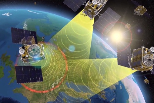
EGNOS is Europe’s first venture into satellite navigation. EGNOS broadcasts augmented information through a trio of geostationary satellites linked to a network of monitoring ground stations, to sharpen the accuracy and reliability of GPS signals across the continent. Photo: EGNOS Europe’s EGNOS augmentation system sharpens the accuracy and reliability of GPS signals so they can safely be used for landing approaches across a growing number of European airports. But aviation is a global enterprise — so the aim is to develop a seamless network of augmentation systems in future.
That is the task of an international group of experts, the Satellite Based Augmentation Systems (SBAS) Interoperability Working Group (IWG), whose 27th meeting took place in Tampa, Florida, September 8-10, hosted by the Institute of Navigation.
Satellite augmentation systems combine dedicated ground stations and satellite transponders to sharpen satnav accuracy and provide integrity data — providing continuously updated reliability levels — across given geographical regions. These systems are based on GPS for now, but plans are to move to a multi-constellation design in the post-2020 era, making use of Europe’s Galileo, China’s Beidou and Russia’s GLONASS systems as well.

SBAS providers from around the globe gathered at Tampa, Florida, for the latest meeting of the SBAS Interoperability Working Group September 8-10. IWG 27 was hosted by the Institute of Navigation. Photo: SBAS SBAS systems enhance any type of location-based satnav use, but in practice, aviation is the main driver. The ESA-developed European Geostationary Navigation Overlay Service, EGNOS, commenced its general-public Open Service in 2009, with the Safety-of-Life Service for aircraft vertical landing approaches following in 2011.For next-generation SBAS systems, the IWG is designing a multi-constellation and dual-frequency standard for heightened accuracy and reliability, building up to offering SBAS coverage on a worldwide basis.
Didier Flament, representing ESA — which co-chaired this IWG meeting with the U.S. Federal Aviation Authority — commented: “Among the achievements of the Tampa IWG has been the presentation of an ongoing review of a standard message definition for the new and second SBAS channel — known as L5 — of the second-generation SBAS system, to be used along with the current L1 signal.

ASECNA Member States. “A single definition coordinated between ESA and the European Commission on one side and the U.S. Federal Aviation Administration on the other is progressing. The formal IWG review loop has started, with the aim of finalizing the convergence for early 2015. The aim is to have it ready to submit to the international SBAS standardization bodies — the International Civil Aviation Organization (ICAO), the U.S. Radio Technical Commission for Aeronautics and the European Organization for Civil Aviation Equipment — in the first quarter of next year.”The meeting also introduced two new SBAS development projects, adding to the five existing projects presented at IWG 26. The first was presented by the Agency for Air Navigation Safety in western Africa and Madagascar (ASECNA), a public international organization with 18 member states.
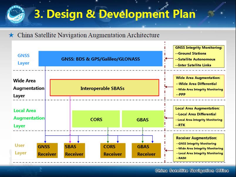
China’s BeiDou SBAS development plan, presented at IWG 27 in September 2014. ASECNA’s project aims to take a two-step approach, commencing with EGNOS-style vertical landing guidance for selected airports, based on EGNOS constituents, with a tentative schedule of 2018, moving to upgrade to the dual-frequency multi-constellation service across the whole of ASECNA airspace after 2020.
The second new project is China’s own BeiDou SBAS. After discussions at ICAO level, China has committed to delivering SBAS services over China that are fully compliant with ICAO standards.
“This new plan has been highly welcomed by the aviation community and other SBAS providers,” Didier said. “Chinese representatives have also confirmed their intention to become part of the SBAS IWG and contribute to the work done to finalise the future standard.”
The follow-up IWG meeting will take place in February 2015 and will be hosted by ASECNA in Dakar, Senegal.
About EGNOS
EGNOS, the European Geostationary Navigation Overlay Service, is Europe’s first venture into satellite navigation. Its development was managed by the European Space Agency (ESA) under a tripartite agreement with the European Commission (EC) and the European Organization for the Safety of Air Navigation (Eurocontrol).
The ownership of the EGNOS assets was transferred from ESA to the EC in April 2009 and EGNOS officially entered service on October 1, 2009. The service is delivered, through a contract with the European GNSS Service Agency (GSA), by the European Satellite Services Provider, ESSP SaS, founded by seven air navigation service providers. ESA is the design and procurement agent for EGNOS on behalf of the EC.