Users can now install and test Touch GIS, a mobile field data mapping app, for as long as needed with a free license tier. Previously, users were able to install the app and sign up for a 14-day free trial period.
“We realized some users needed more time to evaluate the many features of Touch GIS,” said Joe Wilson, head of product for Touch GIS.
Touch GIS, a mobile app available on iPhones and iPads, can be used for geologic exploration, utility mapping, farming, real estate, search & rescue and other applications.
Touch GIS features point, line and polygon drawing features; an offline workflow; WMS/WMTS support; customizable attribute forms; custom feature class creation; SHP, KML, KMZ, GeoJSON, GPX support; and more.
“We’re really excited to be able to offer this new tier,” Wilson added. “We love working with our users to support their needs in the field. The free tier will allow us to do this better. We also hope this will encourage new users to jump in and really kick the tires. We’re proud of what we’ve built and are excited for more people from a variety of industries to discover the apps capabilities.”
Users who wish to unlock offline map caching and exporting capabilities can purchase an annual or monthly license, the company said. In addition, discounts are available for educational institutions, qualified non-profits and credentialed U.S. federal government employees.
Qorvo, a provider of RF solutions, is acquiring Decawave, as well as Custom MMIC. Financial details have not been disclosed.
“This acquisition is by far the biggest in the indoor location industry,” according to Bruce Krulwich, founder of Grizzly Analytics. “While the price is not disclosed, I and others have estimated it at $400-500 million.”
“Apple is using their own UWB chips in upcoming iPhones, but their own chips are too big and use too much power to be used in smartwatches or other small devices,” Krulwich said. “Decawave’s chips will enable Qurvo to sell compatible UWB chips to a much wider range of markets.Apple’s use of UWB in iPhones is the tipping point for UWB. With Apple’s stamp of approval, UWB will be incorporated into a wide range of location-aware electronics, including robots, drones, wearables, smartwatches and more.”
“The biggest implications for this acquisition are not only in the RTLS market, but also in the areas of internet of things, wearables and location-aware electronics,” Krulwich said. “UWB is being used in next-generation products like drones by Intel, robots by iRobot, and autonomous vehicle movement by Segway.”
Bob Bruggeworth, president and chief executive officer of Qorvo, said in a third-quarter financial release that the company was “looking forward to welcoming two industry-leading teams, Decawave and Custom MMIC, to the Qorvo family, expanding our technology portfolio and product offerings.”
Decawave is an Irish fabless semiconductor company specializing in precise location and connectivity applications. The acquisition will advance market penetration of IR-UWB and enable broad global adoption of the technology.
Decawave was founded in Dublin in 2007 by current CEO Ciaran Connell and CTO Michael McLaughlin. The co-founders had a vision that the new IR-UWB technology, based on a nascent IEEE standard, could deliver ultra-accurate location in a way that would revolutionize people’s lives like GPS did in the 1990s.
Twelve years later, IR-UWB is on the verge of becoming the next essential component technology, like GPS, Wi-Fi and Bluetooth before it. Already shipping in millions of smartphones and cars, and across more than 40 other verticals, IR-UWB is enabling accurate indoor location services, secure communications, context aware user interfaces and advanced analytics.
“We are thrilled to announce the acquisition of Decawave by Qorvo,” said co-founder and CEO Ciaran Connell. “We have created an incredibly unique technology, but we understand that to embrace the opportunity in front of us, we will need greater resources to execute at scale, accelerate our innovation and product launches and to continue to support our growing customer base with the same level of service.
“Joining forces with Qorvo’s leading expertise in RF technology, their experience in serving very high-volume markets like Mobile but also the thousands of customers in Industrial and Enterprise, is, for Decawave, a perfect combination to scale and further accelerate the adoption of IR-UWB.”
Eric Creviston, President of Qorvo Mobile Products, said, “We’re very pleased to welcome the Decawave team, which we believe will enhance Qorvo’s product and technology leadership while expanding new opportunities in mobile, automotive and IoT. We look forward to building on the groundbreaking work that Decawave has done and helping to drive new applications and businesses using their unique UWB capability.”
Decawave co-founder Michael McLaughlin added, “From proving a new technology, to building new markets and to today joining a Tier 1 semiconductor company, the past 12 years have been a challenging and fantastic journey.
“None of this would have been possible without the dedication and passion of Decawave employees as well as the constant support from our lead investor Atlantic Bridge, Act Venture Capital, Summit Bridge, Enterprise Ireland and our business angels. To all others who accompanied us on this journey we also say a sincere and profound thank you and we look forward to the next chapter for IR-UWB.”
In the coming months and years Decawave and Qorvo will:
Continue to contribute to the IEEE, Car Connectivity Consortium, FiRa and UWB alliance to define next-generation PHYs and protocols, ensuring interoperability across applications and fueling IR-UWB adoption,
Accelerate the roadmap of ICs and modules, leveraging their respective R&D strengths and product portfolio to bring even more IR-UWB solutions to the market,
Pursue existing partnerships and investments in enablement to offer flexible and easy to integrate IR-UWB solutions to our customers.
Touch GIS has released the Touch GIS app for iPhone and iPad. Users can explore the app’s features with a free 14-day trial.
Touch GIS offers professional-grade field data collection and visualization. It takes advantage of devices already used by many people, making field data collection easy and convenient, the company said.
Features include:
an intuitive interface
offline capabilities
map caching
robust file support
customizable attribute forms
preloaded feature class templates
Users can collect point, line and polygon features, as well as create custom feature classes.
File types supported include Shapefile, KML/KMZ, GeoJSON, GPX and CSV (Export).
Custom Forms:
– Description
– Date & Time
– Photo
– List Of Values
– Checkbox
– Address
– Number
– Website
– Phone Number
Preloaded Feature Classes:
– Forestry
– Geology
– Real Estate
– Stream Surveys
– Water Infrastructure
– Wetlands
– Create Your Own!
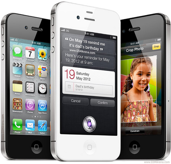
Anyone who owns an older model Apple iPhone or iPad could experience a device-breaking problem on Nov. 3, according to Apple.
The issue could affect iPhone and iPad models introduced in 2012 and earlier.
“If you don’t update to the newest version of iOS available for your device before November 3, some models might not be able to maintain an accurate GPS position. And functions that rely on the correct date and time—such as syncing with iCloud and fetching email—might not work,” Apple said in a blog post.
The problem is because of the GPS time rollover on April 6. Affected Apple devices won’t be impacted until just before 12 a.m. UTC on Nov 3.
The iOS update will solve the problem, enabling the device to maintain accurate GPS location and keep the correct date and time.
Devices affected include iPhone 4s and 5, third and fourth-generation iPad, iPad mini and iPad 2. Learn specifics of affected models and how to update the operating system on the Apple website.
If not updated, these devices might not be able to maintain accurate GPS position or perform functions that require accurate time, such as properly syncing with iCloud or fetching email. The devices also might not be able to receive over-the-air software updates. As a result, the only way to update the device will be to restore it via iTunes or Finder through a tethered connection.
Eos Positioning Systems has announced that its Arrow series of GNSS receivers is compatible with Esri’s Collector for ArcGIS running on iPads and iPhones. The Arrow receivers have been tested and certified as high-accuracy GNSS receivers compatible with Collector 10.4.0 for iOS.
The full range of Arrow GNSS receivers from sub-meter to decimeter to centimeter RTK accuracy all work flawlessly with Collector for ArcGIS running on all iPhones and iPads running iOS 8.x or later, according to the company. GNSS metadata — including estimated accuracy, correction status, correction age and number of satellites used — is displayed in real-time in Collector, so the user can monitor data quality in the field.
“We worked closely with Esri during their development of Collector to ensure the best high-accuracy GNSS user experience with the Arrow GNSS series receivers, and I think we’ve achieved that,” said Eos CTO Jean-Yves Lauture. “Whether it’s our Arrow Lite, Arrow 100 or Arrow 200 receiver, they all work smoothly with Collector for iOS for sub-meter, sub-foot, decimeter and centimeter accuracy.”
Eos Tools Pro.
As a companion software to Collector, Eos offers a free iOS app called Eos Tools Pro that allows the user to connect to an RTK network and to set alarms for estimated accuracy, HDOP, correction age and others. If a threshold is exceeded (such as estimated accuracy greater than 10 centimeters), an alarm sounds on the iPhone or iPad to alert the user.
“We have tested Arrow receivers and confirmed that Collector for ArcGIS (iOS) is completely compatible with the Arrow GNSS series receivers,” said Esri Product Manager Jeff Shaner. “The tight integration between Collector and Arrow GNSS receivers really enhances the high-accuracy user experience, and during our recent beta program, customers like Le-Ax Water District have shared their success using Collector and the Arrow receivers.”
Collector for ArcGIS (iOS) is a geographic information systems (GIS) data collection program that runs on iPhone and iPads. It records data directly, in real time to ArcGIS Online, Portal for ArcGIS and ArcGIS Server at sub-meter, decimeter and centimeter accuracies when using the Arrow GNSS receivers. No post-processing or other specialty software is required.
Collector 10.4.0 can be configured to automatically transform between horizontal datums on-the-fly, so no matter which datum the user’s GNSS data is referenced to, it can be configured to be compatible with the user’s geodatabase, and Esri provides scripts for transforming between vertical datums when back in the office.
Eos GNSS Tools and Arrow receivers are targeted at high-accuracy applications such as GIS; environmental monitoring; agriculture; electric, gas, water utilities; surveying; machine control; and federal, state and local government.
Geneq has introduced a new NTRIP client app for iOS that works with iSXBlue receivers.
iSXBlue RTN is used alongside other geospatial information systems (GIS) and surveying apps to obtain real-time centimeter accuracy on an iPhone or iPad.
Key features include real-time kinematic (RTK) alarm configurations with NTRIP and DIP modes. The easy-to-use app allows users to update their receiver with the latest firmware, the company said.
Other features include real-time map location with accuracy and satellite skyplot for GPS, GLONASS and SBAS. The app supports all current and future constellations such as BeiDou and Galileo, the company said.iSXBlue and SXBlue GPS Receiver users include GIS and surveying professionals in industries such as agriculture, environmental, government, mining, natural resources, surveying and utilities.
Like thousands of water utilities across the U.S., the City of Sebring, Fla., Utilities Department is tasked with providing a safe and reliable water supply, while managing all the dispersed assets of the water distribution and wastewater systems. This means regularly locating, mapping and inspecting assets to maintain service levels and operations.
This City of Sebring storm drain runs down the center of a street. (Photo: TerraGo)
When Sebring evaluated this approach, the city received a quote for geographic information system (GIS) software that was more than $30,000 and bids for surveying services that were as high as $300,000, which didn’t include the mobile tools to collect the data or integration with the existing CAD system.
“We could see the traditional GIS and GPS approach was going to eat us alive cost-wise,” said Mark Kretz, water plant operations, Sebring Utilities.
Sebring Utilities then researched mobile products to see if other organizations had field success using iPads and iPhones to do the work. Sebring still needed to achieve survey-grade accuracy — sub-meter, centimeter-level in some cases. This is impossible with an iPhone or iPad out of the box, which delivers 5 meters at best.
Installation of a storm drain in Sebring. (Photo: TerraGo)
Some tasks, such as mapping an underground valve, need sub-foot or better accuracy. Other tasks, such as locating an aboveground valve, could be seen within 3 to 5 meters, so just the iPad would work.
Mark Kretz, Water Plant Operations, City of Sebring, conducts water asset inspections and maintenance. (Photo: City of Sebring)
CAD integration. Sebring also needed to be able to utilize computer-aided design (CAD) diagrams on its mobile devices to identify and locate valves and other assets in the field. In the past, the utility relied on printed CAD drawings, a cumbersome and costly solution. Plus, with time of the essence when containing a leak, workers wanted on-demand access on their mobile devices.
With the multitude of assets from fire hydrants to valves to sewers, the data collection and maintenance work varied greatly. Sebring needed a way to create custom forms and workflow processes, and be able to modify them over time or create new ones when needed.
In the end, the city opted to deploy TerraGo Edge on iPads. With TerraGo Edge, Sebring was able to integrate with GPS receivers that pair to iPads or iPhones via Bluetooth because the product is fully integrated at the software level with Apple-certified GPS receivers. This enabled the city to cut costs, bring surveys in-house and improve response times for repairs. TerraGo Edge also delivers custom forms, CAD diagrams and survey-grade accuracy.
“On a day-to-day basis, the biggest benefit is that we get the ease of use of an iPad, and didn’t have to buy and use proprietary GPS handhelds, which are more complex and vastly more expensive,” Kretz said.
CAD on iPhone with TerraGo Edge. (Image: TerraGo)
Edge benefits
Cost savings of 90 percent over traditional GIS and GPS systems
Eos Positioning Systems has introduced a new line of high-accuracy GNSS receivers for smartphones and tablet computers, including both sub-meter and RTK performance for all mobile platforms: iOS, Android, and Windows.
Eos’s entry-level product, the Arrow Lite, is Bluetooth compatible with all mobile devices.
The Arrow 100 is Eos’s advanced real-time, sub-meter GNSS receiver that utilizes both GPS and GLONASS, and is expandable to Galileo, Beidou and QZSS. It offers superior tracking under tree canopy, around buildings and in rugged terrain, the company said. In addition to supporting SBAS in North/Central America, Europe, Northern Africa, Japan, India and Russia, the Arrow 100 also supports OmniSTAR’s worldwide, real-time sub-meter service.
The most advanced Arrow receiver is the Arrow 200, a dual-frequency, multi-constellation RTK GNSS receiver capable of 1-cm accuracy in real time. The Arrow 200 is an iOS-compatible RTK and OmniSTAR receiver that works with all models of iPads and iPhones via wireless Bluetooth connection. An iOS NTRIP app that allows the user to log into any available RTK network. The Arrow 200 will provide quality RTK performance for years to come because it supports current and future satellite constellations: GPS, GLONASS, Galileo, BeiDou and QZSS, the company said. It also supports OmniSTAR’s G2, XP and HP real-time worldwide decimeter services.
“After spending more than 12 years designing high-accuracy Bluetooth GNSS receivers, I believe Eos has set the new standard for high- accuracy GNSS receivers that work across all mobile platforms, no matter if it’s iOS, Android or Windows,” said Chief Technology Officer Jean-Yves Lauture.
All Arrow receivers employ long-range (1-km) universal Bluetooth connectivity so the user can interface to any brand of smartphone or tablet, whether it’s iOS, Android, or Windows-based. A variable-power Bluetooth implementation allows the Arrow receivers to communicate up to one kilometer from the mobile device.
Arrow receivers have been optimized to run all day on battery power. The battery pack is field-replaceable and rechargeable separately. It contains smart charging logic so expensive battery chargers are not needed.
All Arrow receivers have been designed to meet IP-67 specifications for immersion in water and are completely dust-proof so they will survive in the harshest environments.
The Arrow receiver product line is targeted at high-accuracy applications like GIS, environmental, agriculture, electric/gas/water utilities, surveying, machine control, and federal/state/local government.
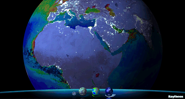
Available for iPhone, iPad and Android, VIIRS View provides mobile device users a look into the type of data meteorologists and climatologists use every day to track the weather and monitor Earth’s environment.
Based on data generated by the Visible Infrared Imaging Radiometer Suite aboard Suomi NPP, VIIRS View combines visible light imagery, low-light nighttime imagery and ocean chlorophyll concentration onto a full Earth globe, rotatable and zoomable on any location on the planet.
A desktop version of the VIIRS View app, launched in February, has been downloaded more than 90,000 times.
An original large format VIIRS View interactive tabletop display is being shown at Raytheon Booth #203 at the the 30th Space Symposium, being held this week in Colorado Springs, Colorado. GPS World Defense Editor Don Jewell is providing coverage from the symposium.
The app can be downloaded by searching VIIRS View at the Google Play and Android stores, or by clicking here:
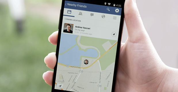
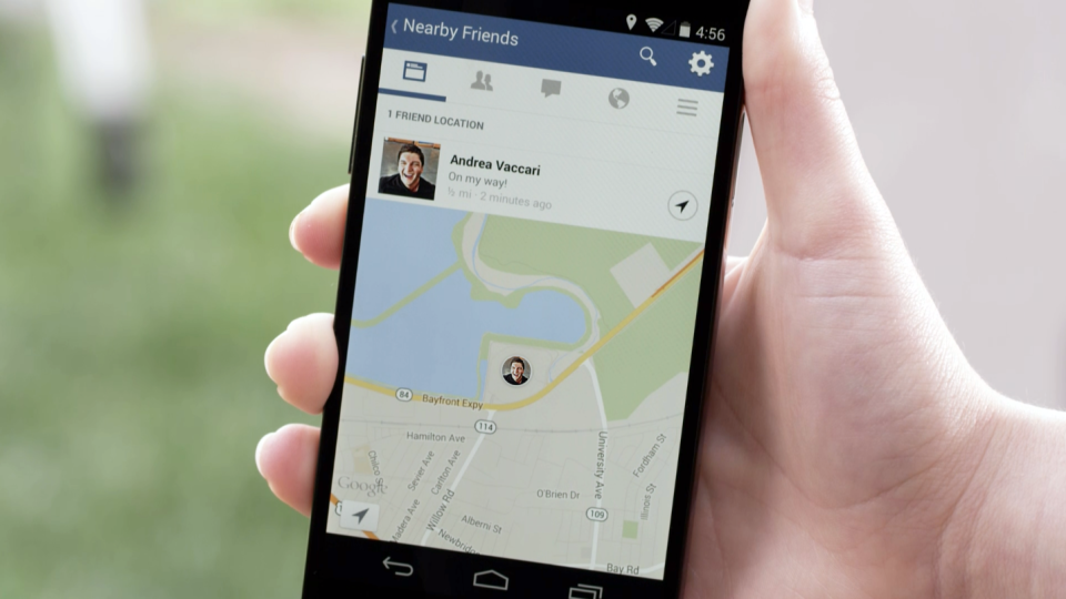
Facebook Nearby Friends feature helps people get together.
While Facebook has made big news buying companies for billions of dollars, it hasn’t been making many location-based services headlines. The recent announcement that it is rolling out a friend finder is interesting news, not only for social applications, but the potential indoor positioning markets. The news is also interesting because as many as half of Facebook users access the social media network through mobile devices.
Signaling that it does have a location strategy, as GPS World reported earlier this week, Facebook announced that it was launching an LBS offering called Nearby Friends. The opt-in service allows users to find out what friends are nearby or mobile.
Nearby Friends will be available on Android and iPhones in the U.S. market this month. In Facebook’s press announcement, apparently privacy is a big issue as the company insists it is an opt-in function.
Once users agree to use the service, they will be notified when friends are in close proximity. Users can select the friends who can see their location — and can turn the service on or off at any time.
At first glance, Nearby Friends could be a valuable tool for users looking to find friends and make plans, but the real potential could be for retailers who wish to drive in-store traffic. Users can not only invite friends to a specific business on a map, but tag other traffic.
The area or business to where the friends are traveling will be displayed on their profile. This allows the friends who opt in to recommend shops, restaurants and other things to do in the specified area.
How retailers get their message out to Nearby Friends users remains to be seen. Research company Berg Insight still says advertising will constitute the main revenues for social networking and local search market segments. However, in several published reports, users have tired of the increased Facebook advertisements.
Berg says that social networking and entertainment has now overtaken mapping and navigation as the largest location market. The company says that those services include general social networking, messaging apps, friend finders such as Nearby Friends, and games.
While Facebook could use the Location History in Nearby Friends to make money selling ads, the company says it isn’t right now. But it has to be the future — and one that, privacy issues aside, could be very lucrative for the company. It could target opt-in users with ads that are only a few feet away or in the area they will meet friends.
The Wall Street Journal reported that Facebook will leverage its user base, estimated at one billion users, to improve ad targeting, expand marketing reach, and to make more money. The company earned $1.24 billion in revenue through mobile ads for the last three months of 2013, according to published reports.
After the announcement that Facebook was launching Nearby Friends, a number of tech business articles sprung up about potential, real and imagined, privacy issues. With the predictable privacy issues comes opportunities for location startups. A new location app is touting itself as the “anti-social networking” tool. Called Cloak, and available in Apple’s App Store, it allows a user to avoid friends they want to avoid by revealing the location of contacts — while keeping the user’s position hidden.
The app, which already has been downloaded more than 100,000 times, uses Instagram and Foursquare data, and published reports say Facebook compatibility is coming soon.
Rumors about Acquisition Prove False?
Earlier this month, several tech business industry publications wrote that Israel-based indoor navigation startup ShopCloud was in talks with Samsung to sell the company for as much as $90 million. Samsung has denied the rumors.
In articles like these, red flags always include terms like “several sources familiar with the details”. The price seemed high for a young company that hasn’t launched a product, though according to published reports, it has an app called Inside.
One analyst says that the Israel tech business media frequently pumps up local companies and even creates buzz for startups — and often these reports are picked up by local journalists.
Autonomous Vehicles Will Happen, but When?
In January’s Transportation Research Board (TRB) meeting in Washington, D.C., attendees agreed that self-driving vehicles are the future. The bottom line is when is the future? “We have seen the business case for autonomous vehicles — it will be a reality. When you look at the number of lives it will save, efficiency of the network, it is very compelling,” said Kevin Link, Verizon senior vice president and general manager, China. “We have to begin a slow migration of educating consumers — one of those ways is through the connected vehicle. I don’t think consumers are there yet.”
Link talked about autonomous vehicles at the Consumer Telematics Conference, also in January, but those at TRB are mainly academics and government officials, not business executives. Most believe it will take decades, Google car aside, to have a fully autonomous vehicle on the road. Others believe that if Detroit does not take notice, they can read about Google dominating this vehicle market, not being a player in it.
In other location news:
Place, the Business of Location conference will be July 22 in New York. Executives from SK Telecom, Thinknear, Sonic Notify, Aisle411, and Factual will join Google, retailer Alex and Ani, and agency MEC North America (WPP), among others. The conference will include case studies and explore how mobile, offline tracking and indoor location will change the future of digital marketing and brand advertising. Many location conferences have died in the last two years, so it is refreshing to see a conference with a strong agenda back on the scene.
Finland-based IndoorAtlas rolled out an indoor mapping application for iOS. While iOS supports Apple’s iBeacon micro-fencing solution for indoor positioning, IndoorAtlas uses the compass chip built into smartphones and does not require external hardware such as Bluetooth beacons or Wi-Fi to determine location, the company said.
The U.S. Patent and Trademark Office awarded Apple a patent that could drive technology on the next generation iPhones. The patent describes a system that combines GPS, Wi-Fi access points, and on-board location databases to provide mobile devices positioning data in all types of environments, particularly indoor location.
It’s been two years since I wrote a column entitled Mobile Device Operating system wars: Android vs. iOS vs. Windows Mobile. After traveling and attending countless conferences and listening to a large number of mobile device users in the geospatial user community, I think it’s time to touch on this subject again, and what a crazy and confusing landscape it is. First of all, let’s frame the discussion in terms of the geospatial users, because that’s the soup we swim in.
At the end of the day, we are driven by the geospatial software we use, so this limits the type of mobile device we can select from. For example, Esri’s ArcPad runs on Windows Mobile and Windows desktop. If that’s the software you want to use, then you can’t use an Android device, an iPad, or a Windows Phone device. In another example, AutoCAD 360 for mobile, which I used a few weeks ago in the field, runs only on Android and iOS devices, not on Windows Mobile devices.
Chart Source: The Wall Street Journal, Gartner
While it appears Android is the dominant mobile operating system of the future, it depends on who you talk to. Right or wrong, some (maybe a lot of) enterprise organizations are scared of Android. They are scared because of one word: security, or more specifically, the perception of the lack of security. Android is open source, and it scares the heck out of enterprise IT (information technology) departments. It scares some to the point that they are shutting down projects that are proposing to deploy Android devices in the field. Is the fear justified? It’s probably more hyped up than it deserves, but IT folks are pretty conservative these days.
Where does that leave the enterprise organizations? iOS or Windows?
Some organizations are going with iOS, but the number of enterprise geospatial apps for iOS is very limited, and most of those that exist aren’t very powerful. They can’t even deal with datum transformations. That means the hardcore iOS enterprise users are left developing their own software, which some are doing. The other limitation of iOS is the hardware device selection. Since Apple doesn’t license iOS to anyone, you have the iPad and the iPhone and that’s about it. Not much selection.
That leaves us where we started…Microsoft Windows.
Dell Venue Tablet
My gut tells me that Windows is making a comeback among geospatial users, even though Windows operating system market share is minuscule compared to Android and iOS on mobile devices. Part of the reason is a plethora of high-quality, Windows-based tablets and pads. Recently, I’ve had the chance to handle some Windows-based tablets such as Dell Venue tablet and Panasonic ToughPad. They are nice tablets for field use. Thank Apple for driving manufacturers to produce good quality tablets at a reasonable price. The other part of the reason, and the major driver, is security. IT departments simply trust the security features that Microsoft provides more than iOS and Android. In the age of security breaches such as the recent Heartbleedbug, the emphasis on computer security is at an all-time high.
Panasonic ToughPad
Security may be the catalyst that pushes Windows back into the forefront of operating systems for the enterprise geospatial user. That’s good news for geospatial software developers. Pressure has been mounting for geospatial software manufacturers to introduce Android- and iOS-compatible versions of their software. Now, with the security issue at the forefront and the availability of high-quality Windows-based tablets at reasonable prices, developers may have some breathing space.
But wait: Which version of Windows?
Windows Mobile? Windows Phone? Windows Embedded Handheld? Windows Desktop? Windows RT?
They aren’t all the same, and they all don’t run the same software. For example, software built for Windows Mobile won’t run on Windows Phone or Windows Desktop.
Microsoft’s mobile operating system strategy has been confusing at best. In past years, it’s been clear that mobile devices run Windows Mobile. It’s not so clear any longer. Microsoft discontinued mainstream support for Windows Mobile 6.1 and 6.5 in January 2013. It’s not as bad as it sounds because in the three years I’ve owned a Win Mobile 6.5 Pro device, an update was never issued. But what it does say is that Microsoft is done with it. No new devices will be designed with Windows Mobile 6.5. However, that’s not to say that Windows Mobile devices are going away. Microsoft just renamed it to Windows Embedded Handheld 6.5, which Microsoft says it will provide extended support for until January 2020. So, all is well, just a different name.
Microsoft’s mobile strategy has turned off manufacturers, and it shows. Given that Microsoft has stopped supporting new devices running Windows Mobile since January 2013, how many devices have you seen introduced since then that support Windows Embedded Handheld? The answer is, not that many, and the ones that do support it are handhelds selling at a premium price, upwards of $1,500 or more. That’s tough to justify when you can buy a tablet or pad for equal or less. And…..the tablets and pads are running full Windows, not the mobile, handheld or phone version so they’re able to run a greater number of off-the-shelf software programs.
Given the above, I feel the tide is turning, at least for the geospatial user community. Windows is going to make a comeback and be the go-to operating system for mobile devices, at least for tablet and pad devices. Don’t misunderstand me though: Android and iOS will still dominate the market share numbers by far, but that’s the consumer user community, not the enterprise geospatial user community. Windows Mobile devices will still have a niche place in the geospatial user community, but I have to wonder if software makers will continue to support that environment if the sales aren’t significant enough.
Sidebar: For those of you who feel I’ve errantly left out the discussion about ruggedized devices vs. non-ruggedized or semi-rugged consumer devices, I’ll say this. Whenever I’ve encountered an enterprise that has deployed consumer mobile devices in an industrial environment (such as iPad), it invariably answers the question about device reliability with “We’ve had very few problems.” The reality seems to be that enterprise users are taking special care of these devices in the field. Program managers are saying, “Even if each person breaks one per year, it’s still half the price of industrial devices.” The reality is that small percentages are failing.
However, one can’t ignore the outdoor usability issue. The displays on some consumer devices don’t handle sunlight very well, and if the display isn’t sunlight readable, the device is severely limited in the field. The same can be said for wide temperature ranges. Both extreme heat and extreme cold can torture a mobile device that isn’t built to withstand that environment. Test before you deploy. Heat it up in your oven, cool it down in your freezer, and see how it behaves.
There’s certainly a niche market for ruggedized mobile devices, but the significant price difference between those devices and consumer devices are making enterprise organizations think twice about where to spend their money. Lastly, many consumer devices are trending towards semi-rugged as manufacturers are discovering this is one way to differentiate them from the ultra-price-competitive mobile device market.
When one talks about the worldwide location industry, mobile resource management — fleets and trucks, for instance — aren’t sexy at all, but they make money. What is supposed to be sexy is location-based advertising. According to many analysts, location-based advertising has been hampered by a few things: education for both consumers and mobile advertisers, privacy issues, and relevant proximity information so folks can use it to make purchases. Another concern could be the expense of rolling out indoor beacons.
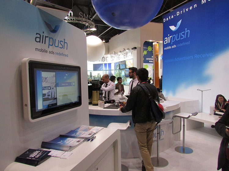
BARCELONA—Major consumer privacy concerns aside, companies are starting to see growth in location-based advertising, with new markets emerging in Europe. While the numbers of mobile advertising companies has decreased at the Mobile World Congress, held here in February, from just two years ago, the remaining players are seeing a more mature market.
Mobile advertisers are beginning to realize that location is the Holy Grail for growth, said Cameron Peeples, Airpush vice president of marketing. “People going into New York from Newark during rush hour can receive a different call to action because of a created geo-fence. Advertisers can determine whether the traveler is there on business or looking for a hotel and other travel deals,” he said.
Before Mobile World Congress, Los Angeles-based Airpush partnered with AirX, a large mobile ad exchange company. The majority of the AirX inventory, about 120,000 Android applications, includes highly-sought-after GPS location data, the company said.
There are large differences between the North American and European markets for mobile advertising, Peeples said. “The mobile advertising market [in Europe] is definitely evolving. The European market is key for us, dramatically higher than other markets,” he said. “[The European] market seems to have people connected to a lot of things — they are more mobile, use public transportation more, and always have a phone that is more centric to who they are.”
Making location-based advertising relevant to the consumer is still a major challenge. “Our focus next year is on native advertising. Native advertising combines not only the right message, but the right delivery vehicle,” Peeples said. “No one bicycling enthusiast wants ads tailored for someone who wants flowers.”
Peeples said the privacy issues are a big deal, but his company’s services are opt-in. “A lot of it is loyalty advertising. It’s all opt-in,” he said.
xAd Partners with Waze, Sees UK Growth
Another mobile advertising company, New York-based xAd, is also making inroads in Europe. “We are in the UK right now, which is really WiFi-focused. A lot of our early [location-based] advertising efforts are in education — to educate consumers and the advertising agencies about the power of location and mobile,” said Monica Ho, xAd vice president of marketing. “Not all location is created equal. The real value of [location-based advertising] is the proximity target to market to.”
Right before Mobile World Congress, Waze selected xAd as its third-party provider of search and display mobile ads in the United States. Waze, which was bought by Google in a deal worth more than $1 billion, is a top three map and navigation app in the iTunes store — a ranking that was probably helped by the Apple Maps debacle in 2012.
The companies say the deal will place xAd’s mobile ad targeting technologies into Waze’s location-based advertising platform.
Ho said there are still two areas of concern for location-based advertising: relevancy to the consumer and privacy issues. “There was privacy backlash from Nordstrom collecting consumer information from their Wi-Fi system,” she said, referring to the controversy last year when the retailer was accused of capturing consumer information during an indoor positioning test.
Apple to Roll out Upgraded Maps on iPhone 6
Speaking about Apple Maps, many industry analysts says the company has come a long way since the very public embarrassment nearly two years ago over map inaccuracies and flaws. The company recently released iOS 7.1, but is expected to rollout iOS 8 when the iPhone 6 debuts later this year.
With the debut of the iPhone 6, an updated version of Apple Maps will also be released, according to published reports.
Last year, Apple bought two companies, HopStop and Locationary, to allow the company to entrench itself once more in the location business. How firmly those roots prove to be, and how well they serve the company against archrival Google, remain to be seen.
Apple has been stockpiling companies and mapping software since its introduction of Apple Maps on iOS devices, which had a rough start. GPS World’s LBS Insiderreported extensively on the problems Apple encountered with its mapping software. Some of these problems included sending drivers to a wrong location and direction.
After the mapping software problems were made public, Apple CEO Tim Cook apologized for the mapping software’s problems and even suggested that users go to such competitors as Waze, MapQuest, and Microsoft’s Bing.
In other location news:
A Wall Street Journal reporter basically said there was nothing much new at Mobile World Congress — and that the excitement and action was at the outlying conferences at Fira Montjuic. One of these more interesting conferences, Four Years From Now, or 4YFN, featured start-up companies making pitches and displaying their new products, some of which included location capability.
The Mobile World Congress final stats. Organizers said MWC had more than 85,000 attendees from 200 countries — an increase of 13,000 from the previous year. It’s now being touted as the biggest and best wireless show.
In February, GPS World reported that TruePosition had purchased Skyhook for an undisclosed price. Skyhook provided location services to a number of companies including Apple and Samsung. The interesting issue is Skyhook’s lawsuit with Google, which alleged that the Internet giant influenced smartphone manufacturers to abandon the Boston-based company. According to published reports, the legal action still is going forward.
AT&T Mobility is shuttering its location-based Alerts marketing program. The company said it would release an updated version later this year. AT&T Mobility launched Alerts in late 2012. It featured free opt-in, location-based text message alert service. Participating retailers included Stapes, Gap, Zales, Neiman Marcus, and others.
I didn’t go to South by Southwest. Is my cool-guy card revoked? One of the reasons I didn’t is because, outside of meetings that were not part of the conference, there was not one location industry announcement made there. Maybe something will change my mind next year, but call me an old fogey — I just didn’t see the need to go to Austin this year.