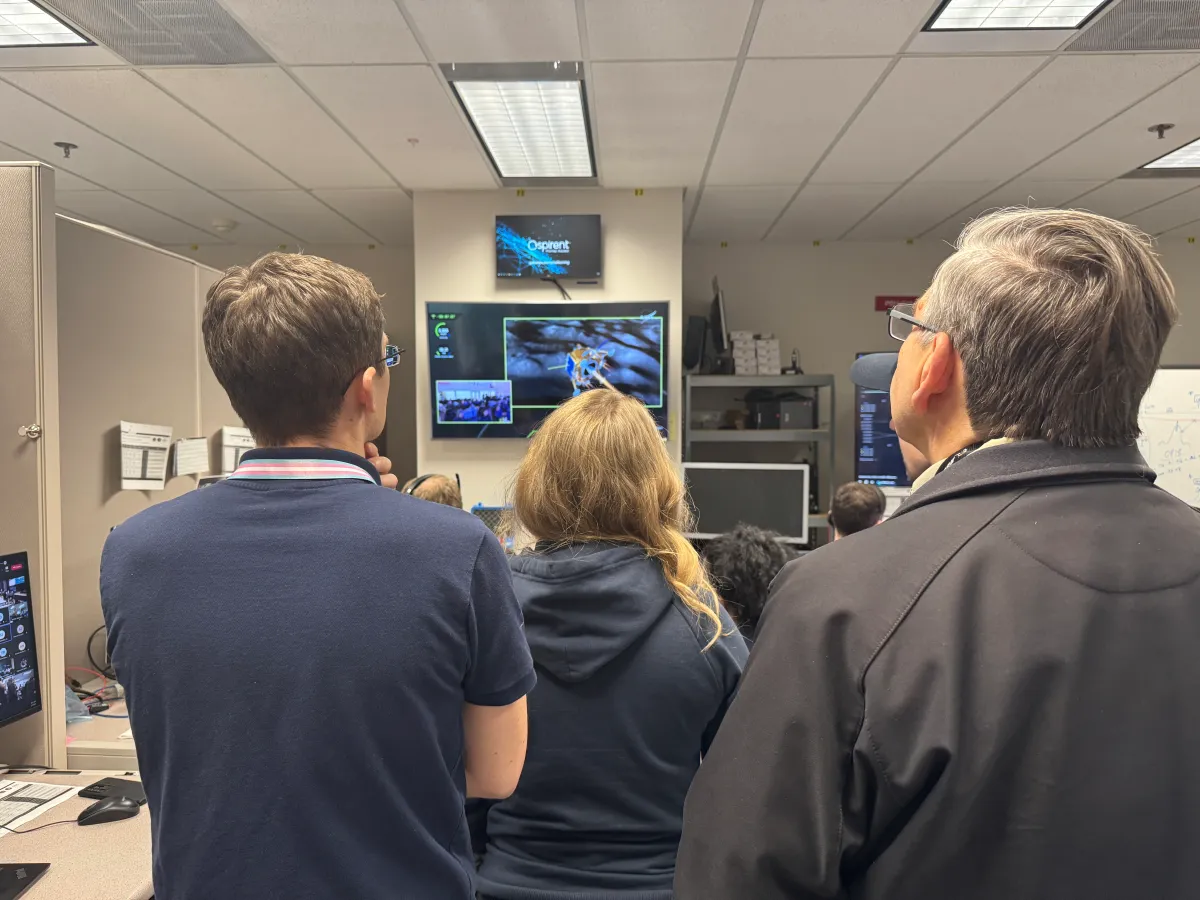
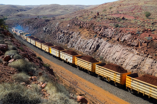
During a public workshop at the Italian Space Agency on Oct. 14-15, the Lunar GNSS Receiver Experiment (LuGRE) project team celebrated the closure of the project and released the data collected to the scientific community.
LuGRE, developed in partnership by NASA and the Italian Space Agency (ASI), flew to the Moon a GNSS receiver manufactured by the Italian company Qascom. The receiver was hosted aboard the Firefly BGM1 mission.
LuGRE demonstrated that signals from GNSS satellite constellations can also be used for positioning, navigation and timing (PNT) on the Moon.
The Navigation Signal Analysis and Simulation of the Dept. of Electroncis and Telecommunications of Polytechnic University of Turin processed the data received during the mission and contributed to all the science team activities, including the validation of the data and the processing of the initial set of scientific results.
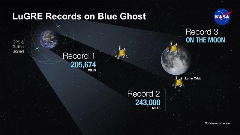
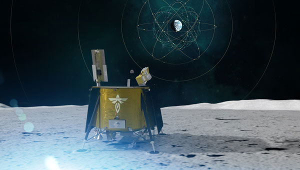
An artist’s concept of the LuGRE payload on Blue Ghost and its three main records in transit to the Moon, in lunar orbit and on the Moon’s surface. (Image: NASA/Dave Ryan)
Launched on Firefly Aerospace’s Blue Ghost lander in January, LuGRE became the first payload to use Earth’s GNSS to calculate a navigation fix on the lunar surface and in lunar orbit. The experiment set a series of distance records on its journey to the Moon, demonstrating that GNSS technology can complement other navigation tools as far as 247,520 miles (398,350 km) from Earth.
These results point to a future where lunar astronauts, rovers and spacecraft can rely on the same satellite-based navigation systems we use every day to augment their navigation capabilities.
“It is a very important milestone for the satellite navigation community,” said Fabio Dovis, Politecnico di Torino, Italian Space Agency, of the project. “For the first time we have the recording of signal of the GPS and Galileo constellation collected in space and on the Moon surface. Already during the LuGRE mission we proved the feasibility of using satellite systems originally designed to be used on Earth up to lunar distances. Now the entire scientific community can use them to ‘re-play’ the space environment as well as analyze them in depth, for example, to retrieve information about the Earth atmosphere crossed by the signal themselves.”
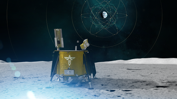
Artistic rendering of LuGRE and the GNSS constellations. In reality, the Earth-based GNSS constellations take up less than 10 degrees in the sky, as seen from the Moon. (Image: NASA/Dave Ryan)
The data release includes the actual GPS and Galileo radio signals LuGRE captured during its journey and on the lunar surface. The raw recordings — called in-phase and quadrature (I/Q) samples — allow researchers to analyze GNSS signal strength, noise and interference under lunar conditions for the first time. Engineers and scientists will use these results to model and refine the next generation of GNSS-based signal receivers and improve our understanding of how navigation signals operate at the Moon.
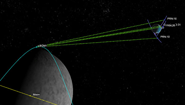
Graphic representation of the relative geometry of Earth-Moon-acquired GNSS satellites. (Image: Agenzia Sapaziale Italiana)
NASA and the Italian Space Agency (ASI) are collaborating on the Lunar GNSS Receiver Experiment (LuGRE), which seeks to demonstrate the viability of providing positioning, navigation and timing capabilities on the moon using GPS and Galileo signals.
LuGRE’s payload consists of a weak-signal GNSS receiver, a high-gain L-band patch antenna, a low-noise amplifier and an RF filter. The receiver is designed to track GPS L1 C/A and L5 signals, as well as Galileo E1 and E5a signals. It will collect pseudorange, carrier phase and Doppler measurements, calculate onboard navigation solutions, and have the capability to record raw I/Q baseband samples for ground processing.
NASA‘s Space Communications and Navigation (SCaN) Program office funded and oversaw the experiment. It was selected as one of ten research and technology demonstrations for lunar surface delivery by Firefly Aerospace, under NASA’s Commercial Lunar Payload Services (CLPS) initiative.
LuGRE builds upon previous missions in the Space Service Volume, including experiments by AMSAT-OSCAR 40, GOES-R series satellites and the NASA Magnetospheric Multiscale mission. It aims to be one of the first demonstrations of GNSS signal reception and navigation in the lunar environment, potentially paving the way for operational use in future lunar missions.
The target launch date for the Blue Ghost 1 mission carrying LuGRE is Jan. 15, 2025. Upon completion, all LuGRE science data will be made available to the public for the benefit of the GNSS and space communities.
Telespazio, a joint venture between Leonardo and Thales, has been selected by the Italian Space Agency (ASI) to lead the creation of the “National GNSS Competence Centre” in Italy. As the primary contractor, Telespazio will head a team composed of Italian universities, research centers, and industrial companies to establish this new center, which will be headquartered at Telespazio’s offices in Rome.
The center’s primary goal is to develop a laboratory network that utilizes resources distributed throughout Italy to advance capabilities, solutions, and technologies in satellite navigation. The project team includes notable institutions such as the National Institute of Metrology Research (INRiM), the Italian Aerospace Research Centre (CIRA), Qascom and the National Inter-University Consortium for Telecommunications (CNIT), along with research units from the University of Pisa, the Polytechnic of Turin, the University of Padua and the University of Roma Tre.
The center will focus on creating new software tools for monitoring GNSS service performance and testing receivers. A cloud-based collaborative platform will be implemented to facilitate shared software development among all project participants. Additionally, the center seeks to expand its network by involving other academic and industrial partners while establishing itself as a national hub for satellite navigation expertise through workshops and training courses.
Telespazio will focus on developing precise, resilient, and robust navigation systems, particularly for emerging technologies such as autonomous vehicles in the aviation, rail, and automotive industries.
Telespazio operates one of two Galileo control centers at its Fucino Space Centre.
Construction of the New National GNSS Frame Network of the Italian Space Agency (ASI) has been completed. The new network, built by e-GEOS, will provide up-to-date, high-precision geodetic information via GNSS signals for the scientific community and professional and entrepreneurial operators. E-GEOS is a company belonging to Telespazio (80%) and an investee of ASI (20%).
There are 46 stations distributed evenly across the Italian peninsula that will acquire the signals from GPS, GLONASS, BeiDou and Galileo.
ASI’s GNSS network, which was designed and developed to provide indispensable support for the global geodetic networks—such as the International GNSS Service (IGS) and the EUropean REference Frame (EUREF)—will produce data for the management of the International Terrestrial Reference Frame (ITRF).
It will make a variety of products and services possible, such as determining the orbits of GNSS satellites with an accuracy to the nearest centimeter. It will also time-synchronize the satellites to better than one nanosecond, useful both for on-site applications as well as to support satellites equipped with GNSS receivers.
The new network will enable ASI and e-GEOS to intensify and fine-tune the joint scientific and operational development underway for the last 25 years at the ASI Space Center in Matera in the field of meteorology, as well as the study of climate change and space weather.
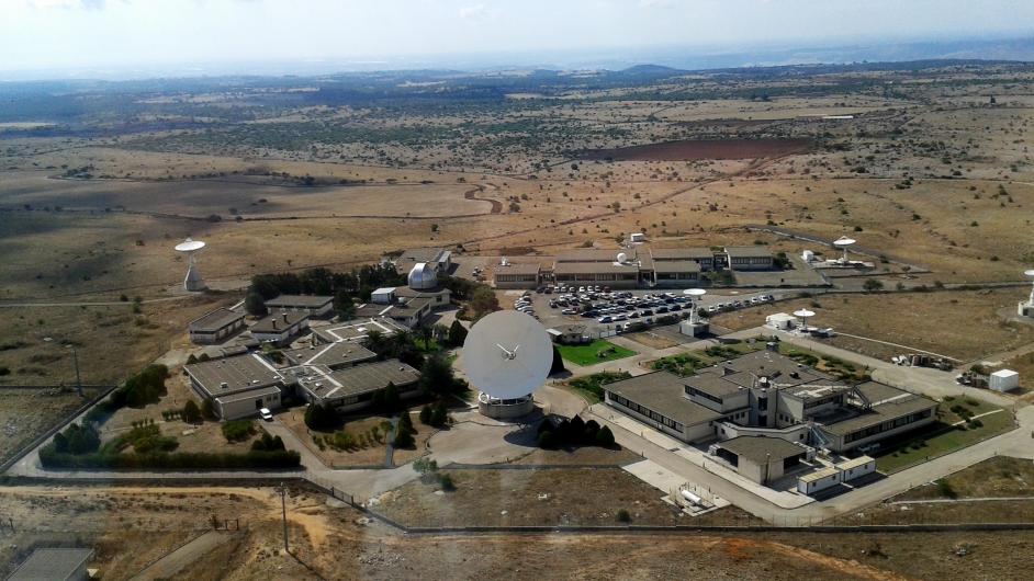
The ASI Space Centre in Matera. (Photo: ASI)
Specifically, the network will enable the provision to the national supply chain—from research centres to SMEs, universities and major corporations—of products and services useful for developing innovative, high-precision positioning applications, which can be implemented in a wide variety of sectors, such as precision farming.
To contribute to scientific activities, some stations in the new GNSS network have been installed in significant locations where purpose-designed structures are already present.
All the data acquired by the New National GNSS Frame Network will be received, processed and stored at ASI Space Centre in Matera and provided to all interested users.
A GNSS receiver is scheduled to land on the Moon in 2023, sent by NASA and the Italian Space Agency (ASI). The innovative GPS and Galileo receiver, provided by Qascom, will experiment with satellite-based positioning on the lunar surface.
The project, dubbed NEIL (Navigation Early Investigation on Lunar surface), is at the center of an agreement between ASI and NASA, linked to the CLPS 19-D mission (NASA’s Commercial Lunar Payload Service, Task Order 19).
The NEIL payload will be integrated into the Lunar GNSS Receiver Experiment (LuGRE), an ASI/NASA cooperation framework to develop activities in lunar and cislunar environments.
For the first time in history, GNSS positioning will be tested at almost 400,000 kilometers from Earth. The previous limit was a distance of 200,000 kilometers, tested in the Magnetospheric Multiscale (MMS) project.
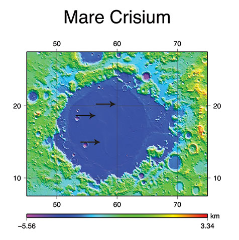
NEIL will be integrated on the NASA’s Blue Ghost lunar lander in 2022. In addition to the NEIL payload, nine other experiments will land on the Moon. The mission is expected to be launched via a SpaceX Falcon 9, and the lander with aim for the Mare Crisium basin.
Image: NASA/Resse Patillo
Moon-Hardened Receiver
Under an ASI contract, Qascom will develop the dual-frequency GPS and Galileo receiver, as well as the entire radiofrequency chain (antenna, LNA, filters), all of which can withstand the extreme environmental conditions of the Moon.
The GPS and Galileo signals received from NEIL will be extremely weak due to the distance from Earth, and will be processed with specific algorithms allowing to calculate position and time, even if with reduced accuracy, both during the Moon transfer orbit and on its surface.
Image: NASA
“This experiment is of strategic importance for Italy, since it will bring our technology to the Moon surface,” stated the Italian Space Agency. “It contributes to strengthening the competitiveness of the Italian space sector and consolidates the strong collaboration between the Italian Space Agency and NASA in the satellite navigation segment as well as in the future Moon and Mars missions.”
NEIL provides also an important technical and scientific contribution to study how GPS and Galileo could be used for positioning and timing in future Moon missions, including for example the deployment of lunar satellite constellations, lunar rovers, the lunar space station Gateway and the infrastructures that are going to be developed in the frame of Artemis programs. The raw measurement collected will be used by the research community to study the lunar and cislunar environment and evaluate the future use of GNSS to support permanent missions.
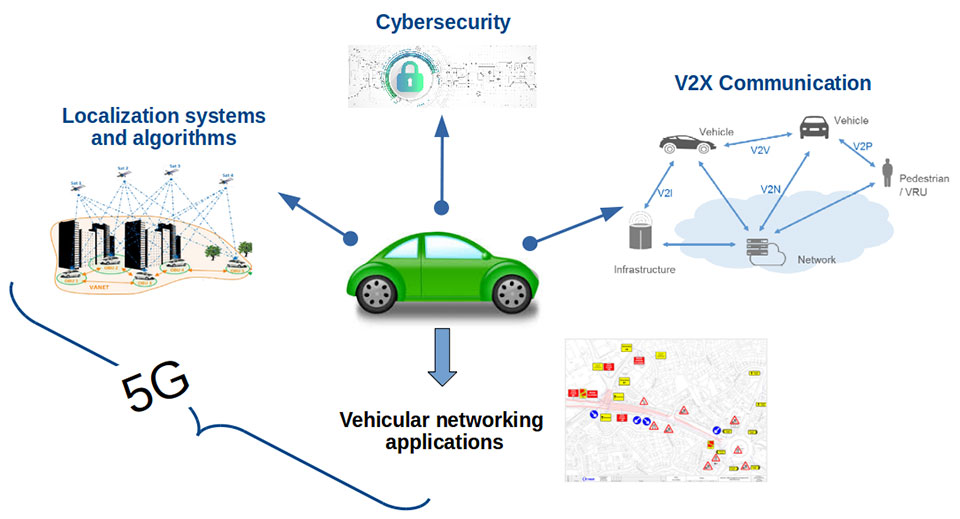
Central Italy — already home to an ambitious national autonomous driving research initiative — will be the site of the P-CARS laboratory, intended to certify positioning devices for use within driverless cars.
The new P-CARS laboratory is financed by the Italian Space Agency (ASI) through the Navigation Innovation and Support Programme (NAVISP) of the European Space Agency. The lab will support the goals of EMERGE, a public-private partnership for innovation established in 2018 between Italy’s Ministry of Economic Development, the University of L’Aquila and the mountainous Abruzzo region. Also in the partnership are the RadioLabs research consortium and the Leonardo, Telespazio and Elital companies.
RadioLabs laboratory at the University of L’Aquila, part of Italy’s EMERGE initiative developing autonomous and connected driving solutions. (Photo: RadioLabs)
EMERGE will develop satellite navigation and 5G solutions for connected, cybersecure and autonomous vehicles. The new P-CARS laboratory will be an independent venue for testing devices supporting autonomous and connected driving.
“The idea behind it is to create a research ecosystem, focused on developing, testing, validating and promoting the use of Galileo and other GNSS — along with 5G communications — for connected and autonomous driving,” said Francesco Rispoli, chief satellite operations at Hitachi Rail STS and director general of RadioLabs.
Abruzzo already hosts a manufacturing site for Stellantis’ Fiat Ducato light truck, the Galileo control center at Fucino, and the connected-car center of the University of L’Aquila. P-CARS will be integrated into the university’s Center of Excellence for Geo-localized, Connected and Cyber-secure vehicles.
Italy’s EMERGE initiative is developing GNSS and 5G technology for autonomous and connected driving. (Image: RadioLabs)
“The P-CARS lab will have a 150-square-meter testbed area, beside an existing driving circuit, with the right to use the surrounding open space as well,” Rispoli said. “We’ll be addressing connected autonomous driving functions with GNSS technologies that are safety critical, the key point being that safety must be ensured through standardized test procedures, serving as a trusted third-party to validate specific solutions from companies.”
“This is a valuable response to our national strategy, promoting the adoption of positioning, navigation and timing (PNT) solutions in the fast growing automotive sector by leveraging the latest technologies brought by Galileo and 5G,” said Alberto Tuozzi, head of ASI’s Navigation and Telecommunication Department. “Cross fertilization, cooperation and interaction among the stakeholders will be pursued in the unique ecosystem of the Abruzzo region, bringing together space and non-space stakeholders: ASI, ESA, satellite and automotive industries, universities and research centers.”
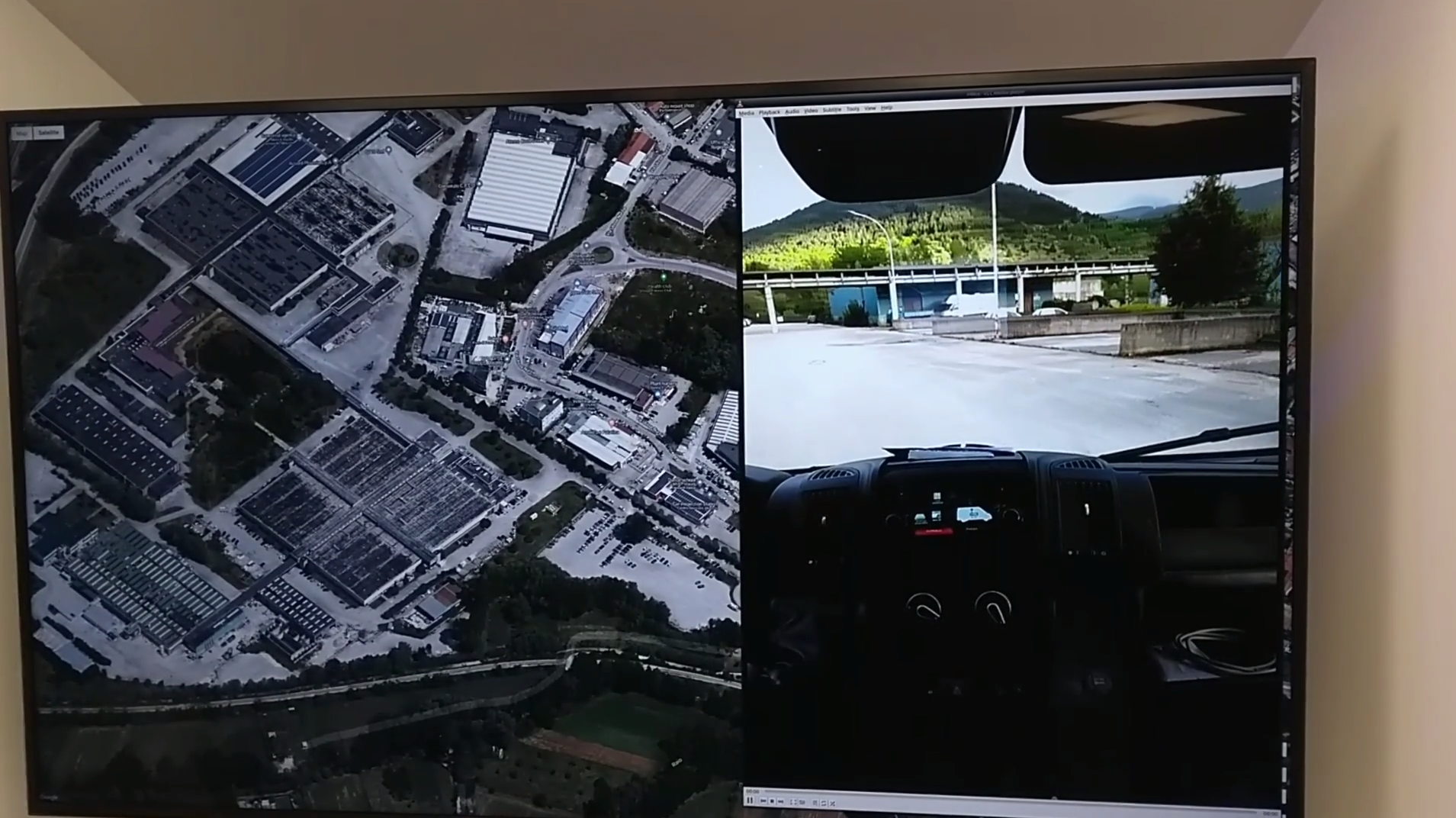
Autonomous vehicles will have two distinct sets of inputs: sensors such as cameras, lidar and radar to know the context around the car; and GNSS and inertial measurement systems to know its position. The two sets work independently but come together to ensure safety. (Photo: RadioLabs)
Leveraging its expertise on Galileo and safety applications, ESA will support this initiative in two ways: with technical support and through cooperation and exchanges with other institutions and laboratories at the international level. ESA said P-CARS could become part of a network of centers of excellence in the PNT domain applied to autonomous cars and beyond.
P-CARS will exploit the synergies between the rail and automotive sectors to provide benefits to both. “Car manufacturers produce millions of vehicles and are investing heavily in autonomy and safety systems, but had little experience in this field before they began investing a few years ago,” Rispoli said. “Meanwhile, the rail community has almost 20 years’ experience managing train driving functions with a high degree of autonomy, through the common European Rail Traffic Management System, ERTMS.”
Hitachi Rail and Rio Tinto collaborated to build the world’s first driverless heavy freight train – an automated heavy haul freight transportation system delivering freight from mines to ports in Australia across thousands of kilometers every day. (Photo: Hitachi Rail)
“It is well recognized that ERTMS guarantees the highest safety levels as a connected and autonomous driving system, where the human driver is largely bypassed, but not the volume for mass producing such systems for reducing their cost. By leveraging these two peculiarities it will be possible to get low cost but safety-proven GNSS-based devices,” Rispoli said.
The emphasis will be on connectivity, with the vehicles linked to the infrastructure, including a centralized system of intelligent roads as well as other cars. 5G will enable low-latency communications and be a source of positioning data to extend the performance of GNSS.
P-CARS is being supported through Element 3 of NAVISP, focused on supporting ESA member states’ navigation priorities.
Check out some GPS developments that have recently taken place around the world. (Click to enlarge; Map: iStock.com/nadla)
1. A new use for GNSS satellites
University of Padua researchers say GNSS satellites make possible global quantum communication, beaming information between a satellite and an Earth-based ground station. They exchanged a single photon over 20,000 kilometers to prove secure quantum communications can be implemented on a global scale using GNSS. Results show the first exchange of a few photons per pulse between two GLONASS satellites, using the passive retro-reflectors mounted on the satellites, and the Space Geodesy Centre of the Italian Space Agency. The results could provide solutions for GNSS security for satellite-to-ground and inter-satellite links by using quantum information protocols for quantum key distribution.
Click to enlarge. (Photo: NASA)
2. GRITSS to improve reference frame
University of Massachusetts Lowell researchers have received a two-year, $1.2 million grant from NASA’s Earth Science Division to develop a Geodetic Reference Instrument Transponder for Small Satellites (GRITSS) to significantly improve the accuracy of the International Terrestrial Reference Frame — the basis of GPS positioning and navigation. A virtual map of the Earth, the ITRF pinpoints specific geographic positions and describes Earth’s precise shape, physical topography, orientation and rotation with time based on a stationary, Earth-centered coordinate system. The location of each GPS satellite is defined within the ITRF.
Click to enlarge. (Photo: Rick Thomas)
3. Pigeon scientists
Engineers from the University of Birmingham have developed a compact backpack to collect climate and pollution data. When the birds return to their lofts, the sensors are retrieved and the data downloaded, including GPS location, temperature, humidity, ambient light and air pressure. So far, scientists have been able to collect data from five birds — they made a total of 41 flights with a total length of about 1,000 kilometers.
Click to enlarge. (Photo: Victor Gevers/ZDNet)
4. China’s big brother program
Evidence that China is tracking its Uyghur Muslim population in the Xinjiang region has been uncovered. A facial recognition database was left open on the internet for months, Dutch security researcher Victor Gevers told ZDNet. The database contains information on 2.5 million people, along with a stream of GPS coordinates. Data includes detailed and sensitive information: names, ID card data, addresses, photos and employers, as well as GPS coordinates where the user had been seen via public cameras labeled mosque, hotel, police station, internet cafe, restaurant and more.
This Landsat 8 image, Caltech acquired on Sept. 6, 2014, is a false-color view of the Holuhraun lava field north of Vatnajökull glacier in Iceland. The Bárðarbunga caldera is visible in the lower left of the image under the ice cap. Photo: U.S. Geological Survey / Caltech
Access to satellite images and GPS data has allowed scientists to document the collapse of the Bárðarbunga caldera, a volcano beneath the Vatnajökull ice cap in Reykjavik, Iceland.
Mark Simons, a professor of geophysics at the California Institute of Technology (Caltech), traveled to Reykjavik with 15 students and two faculty members on Aug. 16, 2014, to lead a tour of the volcanic, tectonic, and glaciological highlights of Iceland. That day, earthquakes occurred — the seismicity was related to the Bárðarbunga caldera.
Simons is one of the leaders of a Caltech and Jet Propulsion Laboratory (JPL) project known as the Advanced Rapid Imaging and Analysis (ARIA) program, which aims to use a growing constellation of international imaging radar satellites that will improve situational awareness and response following natural disasters, according to Caltech. Under the ARIA umbrella, Caltech and JPOL, managed for NASA by Caltech, had formed a collaboration with the Italian Space Agency (ASI) to use its COSMO-SkyMed (CSK) constellation — consisting of four orbiting X-Band radar satellites — following such events.
CSK used an interferometric synthetic aperture radar (InSAR) technique to gather images of the surface of the glacier above the caldera. By the evening of Aug. 28, Caltech says the first interferogram showed that the ice above the caldera was subsiding at a rate of 19.685 inches a day.
Simons took the data to researchers at the University of Iceland who were tracking Bárðarbunga’s activity on Aug. 29.
“At that point, there had been no recognition that the caldera was collapsing. Naturally, they were focused on the dyke and all the earthquakes to the north,” Simons said. “Our goal was just to let them know about the activity at the caldera because we were really worried about the possibility of triggering a subglacial melt event that would generate a catastrophic flood.”
The flood never occurred, but Caltech says the researchers at the University of Iceland increased their observations of the caldera with radar altimetry flights and installed a continuous GPS station on the ice overlying the center of the caldera.
The Icelandic researchers published a paper in December 2014 in Nature about the Bárðarbunga event, largely focusing on the dyke and eruption. Simons and his colleagues have developed a model to describe the collapsing caldera and the earthquakes produced by that action. The new findings appear in the Geophysical Journal International.
Bryan Riel, a graduate student in Simons’s group and lead author on the paper, used the interferogram of the Bárðarbunga area, along with four others collected by CSK in September and October, to show that the earthquakes were not the primary cause of the surface deformation inferred from the satellite radar data.
“What we know for sure is that the magma chamber was deflating as the magma was feeding the dyke going northward,” Riel said in the article. “We have come up with two different models to explain what was actually generating the earthquakes.”
“Because we had access to these satellite images as well as GPS data, we have been able to produce two potential interpretations for the collapse of a caldera — a rare event that occurs maybe once every 50 to 100 years,” Simons said. “To be able to see this documented as it’s happening is truly phenomenal.”