ArkEdge Space Inc. has completed a study commissioned by the Japan Aerospace Exploration Agency (JAXA) on “Elemental Technologies and Systems for a Dedicated, GNSS-Independent LEO-PNT Satellite System.”
Positioning, navigation and timing derived from GNSS is increasingly subject to interruption and interference, both through environmental and security challenges. Finding methods to protect PNT information against such interference is of paramount importance for governments and commercial actors alike.
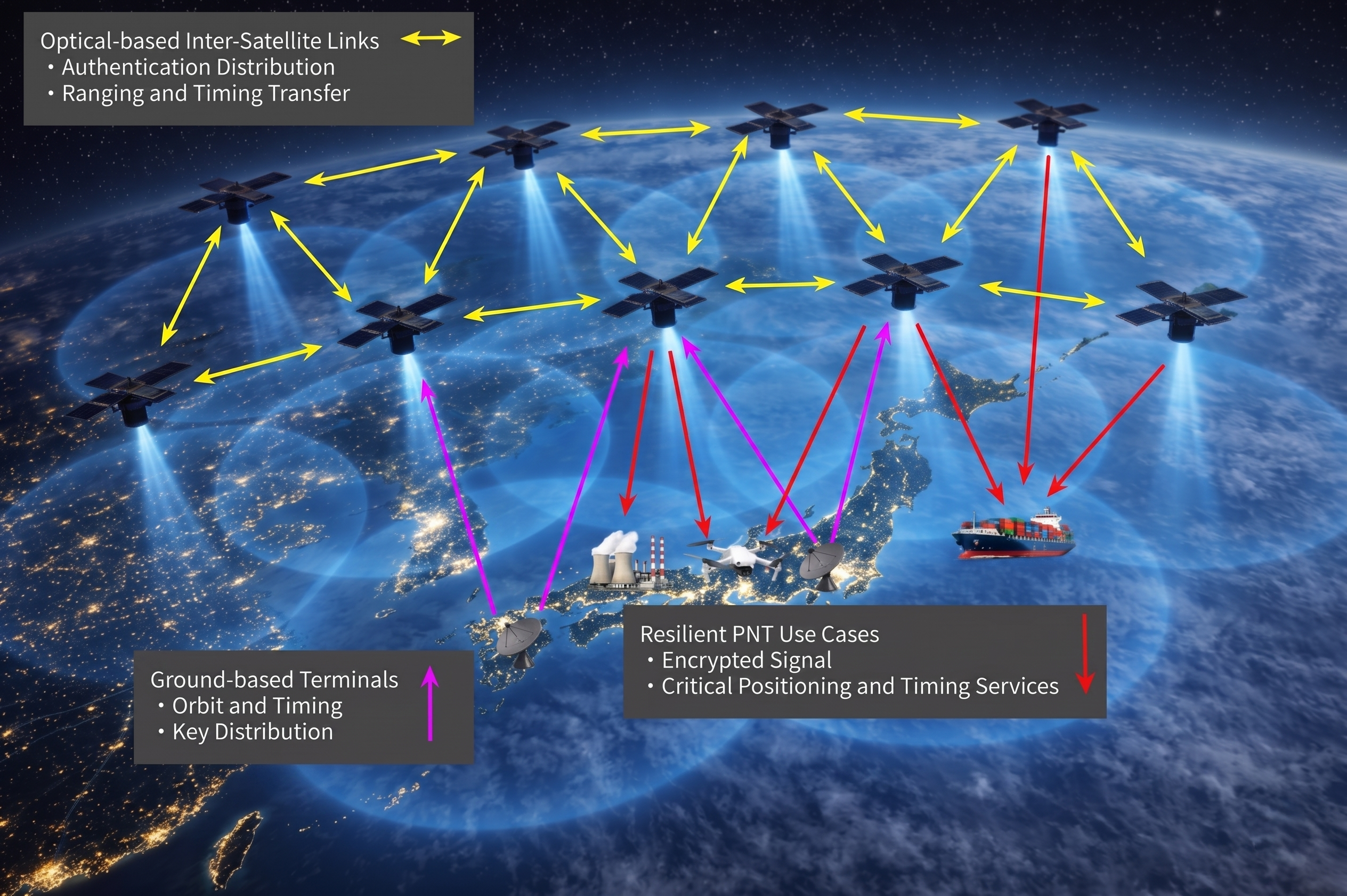
The ArkEdge/JAXA project addressed such challenges by examining and categorizing the necessary elemental technologies — signal design, receiver technology, ground infrastructure, satellite sensors, and the overall system architecture — required to realize a LEO-PNT system capable of providing PNT without reliance on traditional GNSS.
The study’s focus included achieving satellite orbit determination and time synchronization without GNSS, one of the key challenges facing alternative PNT providers. It explored a new architecture for onboard time determination that avoids the need for large atomic clocks. Instead of onboard clocks, the system transmits precise timing information from combinations of ground-based reference clocks, pseudolites and inter-satellite optical links to disseminate information and enable on-orbit ODTS.
Concept art of the LEO-PNT satellite constellation. (Credit: ArkEdge Space)
The study considered diverse frequencies to strengthen anti-jamming measures. It also looked at novel signal design, receivers, encryption and signal authentication methods, and their suitability for LEO-PNT satellites. Results of the study will contribute to the next stage of development for a GNSS-independent LEO-PNT concept.
“This study is critical to advancing our understanding of Japan’s future relationship with PNT,” said ArkEdge Space Chief Strategy Officer Tomoaki Yasuda. “Across the world, users are facing denial of GNSS services, and that can have critical consequences for sectors including the economy, transport and emergency services, among others. We look forward to progressing the GNSS-independent LEO-PNT concept with the support of our partners.”
“Due to the prevalence of GNSS interference, alternative PNT systems are becoming increasingly important to protect users and assets such as critical national infrastructure,” said Masaya Murata, JAXA. “Following the successful conclusion of this GNSS-independent LEO-PNT study with ArkEdge Space, our investigation into a robust and resilient LEO-PNT system continues. We are also emphasizing international cooperation with other LEO-PNT providers to maximize users’ PNT experience and continue to engage in collaborative discussions.”
Japan Aerospace Exploration Agency (JAXA) has selected ArkEdge Space to develop a satellite positioning system designed to complement existing GNSS.
The company signed a contract begin the “Study of Elemental Technologies and Related Systems for Low-Earth Orbit Positioning Satellite Systems,” (Dedicated LEO-PNT). ArcEdge Space, led by CEO Takayoshi Fukuyo, provides solutions for microsatellite constellation planning, design, mass production and operation.
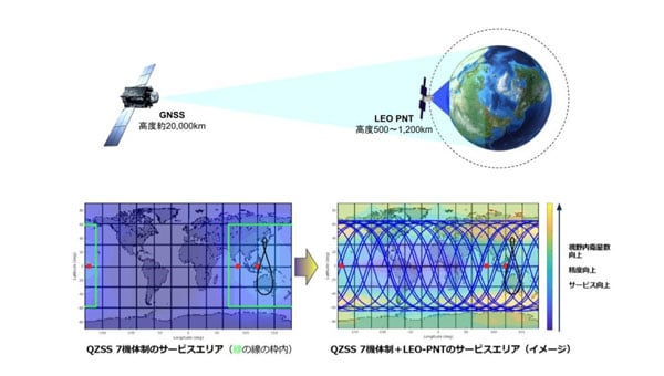
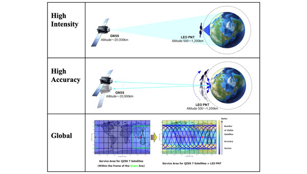
The LEO-PNT satellite system uses small satellites orbiting at altitudes between 500 km and 1,200 km to provide high-intensity, high-precision positioning information globally. Traditional GNSS satellites orbit at approximately 20,000 km.
Conventional GNSS technology faces growing threats from jamming and spoofing attacks because weak signals reach Earth’s surface. The LEO-PNT system’s high-intensity positioning signals seek to address these vulnerabilities.
The project builds on JAXA’s feasibility study conducted from October 2024 to March 2025. Researchers will examine technologies and systems for providing robust position and time information to ground users as an alternative to GNSS.
The system’s main feature is GNSS-independent service that can operate when existing systems are disrupted or jammed. Engineers will study transmitting LEO-PNT signals across C, S and L frequency bands, including C1 band (5010-5030 MHz) and C2-4 band (5030-5250 MHz).
Project Details
The study runs from September 2025 to March 2026 and includes signal design, reception technology research and system studies for GNSS-independent LEO-PNT systems.
Key Advantages
High intensity: Lower orbital altitude enables stronger positioning signals that resist attenuation and interference.
High precision: Rapid changes in satellite line-of-sight vectors allow faster positioning convergence, supporting applications like autonomous driving and precision agriculture.
Global coverage: Satellites in LEO can extend services currently limited to QZSS coverage, such as MADOCA-PPP.
ArkEdge Space said the technology will contribute to highly automated societies and a safer future.
The Japan Aerospace Exploration Agency (JAXA) has selected Spirent Communications to supply its lunar positioning, navigation and timing (PNT) simulation solution. The solution will support JAXA’s lunar exploration efforts and aid in developing essential navigation infrastructure for future moon missions.
Spirent’s PNT X solution allows JAXA to simulate lunar PNT services in a controlled laboratory setting before their deployment on the moon. This capability is critical for testing and validating navigation equipment for lunar missions in accordance with the emerging LunaNet specifications, which include adaptable S-band frequency solutions. The system also ensures scalability for future space exploration.
Using the PNT X system, JAXA can experiment with novel S-band signals and evaluate the performance of receivers that rely on standalone S-band Lunar PNT signals or a combination of Lunar PNT and Earth-based L-band GNSS infrastructure. The simulation of these signal combinations demands high levels of precision, which Spirent’s specialized architecture is designed to meet.
This collaboration builds on a longstanding relationship between Spirent and JAXA. In 2011, JAXA utilized Spirent’s simulation technology to verify the performance of early Quasi-Zenith Satellite System (QZSS) receivers. Since then, Spirent simulators have supported multiple advancements in QZSS.
Spirent’s lunar PNT simulation solution seeks to present new opportunities for space agencies developing lunar constellations, satellite and receiver developers and organizations planning lunar missions or seeking to establish additional PNT infrastructure on the moon.
ArkEdge Space, a Japanese space start-up based in Tokyo, has been selected by the Japan Aerospace Exploration Agency (JAXA) under its Space Strategy Fund to lead the development of advanced lunar navigation technology.
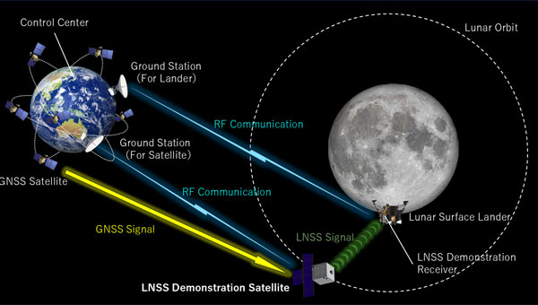
Under the agreement, ArkEdge Space will plan and design the mass production and operation of micro-satellite constellations to lead the development of a next-generation Lunar Navigation Satellite System (LNSS), a vital component to the International “LunaNet” initiative driven by National Aeronautics and Space Administration (NASA), European Space Agency (ESA) and JAXA. LunaNet seeks to establish essential infrastructure to support sustainable lunar exploration and foster the growth of the lunar economy.
This program, supported by up to 5 billion yen ($32.5 million) over four years, tasks ArkEdge Space with developing a 100 kg class micro-satellite, developing crucial technology including the:
Lunar navigation payload
Demonstration satellite platform, along with a system operations plan
Establishment of an approach to mission evaluation
These efforts will help reduce development costs and timeframes while advancing core LNSS technologies and enabling the development of future lunar navigation system demonstration satellites, according to ArkEdge Space.
ArkEdge Space’s work on LNSS leverages its expertise in satellite technology and builds on its ongoing collaboration with JAXA. A key innovation of the project involves the use of faint GNSS signals, originally designed for Earth, to determine satellite position and time in lunar orbit—approximately 380,000 km from Earth. Additionally, LNSS complements advancements in low-Earth Orbit positioning navigation and timing (LEO-PNT) systems, designed to provide high-precision, robust navigation services globally, enhancing existing GNSS infrastructure.
As lunar exploration accelerates, high-precision infrastructure has become indispensable for activities such as rover navigation, base construction, and in-situ resource utilization. LNSS supports lunar operations and serves as a stepping stone for future exploration of Mars and deep space.
The Japan Aerospace Exploration Agency (JAXA) has awarded Japanese startup ArkEdge Space a contract to study the feasibility of establishing a constellation of positioning, navigation and timing (PNT) satellites in low-Earth orbit. The project aims to provide high-precision PNT signals across the globe.
Government agencies worldwide are exploring ways to complement and back up GNSS, which is susceptible to natural and deliberate interference. In addition, self-driving cars and autonomous drones require extremely precise location data.
Under the new JAXA contract, ArkEdge Space will provide a conceptual design for a LEO-PNT satellite and its orbit. ArkEdge will also explore satellite and constellation tradeoffs and consider different signal formats and frequency bands.
With a new LEO-PNT constellation, JAXA seeks to expand the coverage area of service currently provided by Japan’s geostationary Quasi-Zenith Satellite System (QZSS) satellites.
Under a separate JAXA contract, ArkEdge is developing positioning and communications services for cislunar space.
In early 2015, the Navigation Support Office of the European Space Agency (ESA) and the Japan Aerospace Exploration Agency (JAXA) began a collaboration. At its core, the ESA-JAXA collaboration is designed to cross-validate Japan’s Quasi-Zenith Satellite System (QZSS) Precise Orbit Determination (POD) results and share expertise to improve the POD accuracy of QZSS.
The cross-validation of the QZSS POD performance was implemented by jointly analyzing QZSS observations and validating the POD results of the QZSS satellites. As a result of this joint activity, ESA and JAXA have significantly improved the robustness and accuracy of their respective POD products. This collaborative approach not only ensures the continuous improvement of QZSS force modeling and precise orbit determination performance but also demonstrates the effectiveness of international cooperation in advancing the field of space navigation, especially as the benefits of GNSS interoperability become very evident.
An important milestone in this collaboration was ESA’s role in supporting the In-Orbit Testing (IOT) activities for QZS-1R towards the end of 2021. The successful execution of these tests demonstrated the practical results of the ESA-JAXA partnership and further solidified the commitment of both agencies to enhance their capabilities for QZSS POD and associated products.
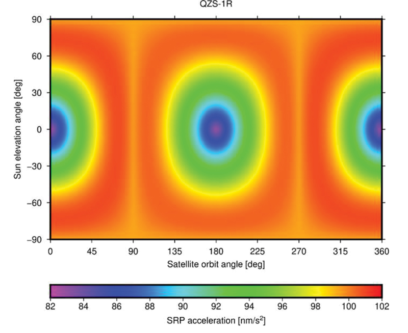
FIGURE 1 ESA’s Solar Radiation Pressure (SRP) model output in satellite-Sun frame.
The benefits of this collaboration extend beyond the agencies to the entire scientific community. Notable achievements include the revision of metadata for the QZSS constellation, such as the optical properties of the QZS-1 solar arrays, which have been refined and improved through shared expertise, while simultaneously releasing the satellite mass and attitude mode history in a machine-readable file format for easy access and adoption by the users.
To evaluate the spacecraft models and metadata for QZS-1R prior to their public release, ESA and JAXA conducted several comparative tests. Since both organizations use different software packages for satellite POD — ESA uses NAPEOS (Dow, Springer 2009, Enderle et al., 2019 and 2022) and JAXA uses MADOCA (Kawate et al., 2023) — their results can be considered as largely independent. One comparison involved the Solar Radiation Pressure (SRP) model results produced by both organizations. FIGURE 1 shows the accelerations in satellite-Sun frame computed by ESA’s SRP model. The comparison of the computed SRP accelerations in different reference frames, spacecraft-fixed and inertial, showed excellent agreement with differences of less than 0.1 nm/s².
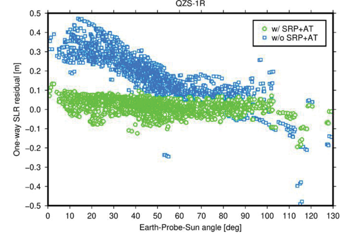
FIGURE 2 One-way Satellite Laser Ranging (SLR) range residuals calculated with respect to QZS- 1R orbits generated with (green) and without (blue) a-priori radiation force models and displayed as function of the Earth-Probe-Sun angle.
In addition, pseudo-range and carrier phase dual-frequency measurement data from 200 tracking stations of the International GNSS Service (IGS) network were used to generate precise QZS-1R satellite orbits and clock offsets on a day-to-day basis over a 12-month period spanning from January to December 2022. Comparison between ESA and JAXA solutions yielded a root-mean-square (RMS) agreement of 8.6 centimeters (orbit) and 0.21 nanoseconds (clock), respectively. Analysis of Satellite Laser Ranging (SLR) data from seven stations of the International Laser Ranging Service (ILRS) suggests a radial RMS accuracy of the generated orbital trajectories of about 4 cm. Without applying the analytical models for SRP and other non-gravitational perturbation forces, such as antenna thrust (AT), the RMS accuracy decreases by a factor of five (FIGURE 2).
In conclusion, the ESA-JAXA collaboration on Japanese Quasi-Zenith Satellite System POD has been a resounding success. Through this continuous and mutual support, performance cross-validation and knowledge sharing, significant improvements related to modeling and subsequently to POD accuracy could be achieved for ESA as well as for JAXA. Additionally, the global scientific community benefitted from this ESA/JAXA collaboration via improved QZSS POD products and validated metadata.
The Japan Aerospace Exploration Agency (JAXA) has selected a contractor for a study of positioning in space after an open-call competition.The study, part of “Development of Positioning and Communication Technology for Monthly Activities,” will consider possible lunar positioning satellite systems and ultra-long-range communication systems between the Moon and the Earth.
Artist’s rendering: NASA
JAXA is managing the project, with Ark Edge Space Co. Ltd. serving as the outsourcer for a consortium of companies and academia. Consortium members include Ark Edge Space, AAI GNSS Engineer Office, Kiyohara Optical Co. Ltd., KDDI Corporation, KDDI Research Institute, the University of Tokyo Graduate School of Engineering and Mitsubishi Precision Co. Ltd.
From Jan.1 to March 25, the consortium is studying a comprehensive architecture for positioning and communication systems that will be the basis of lunar exploration, including a lunar positioning satellite system that takes into account the ultra-long distance between the Moon and the Earth.
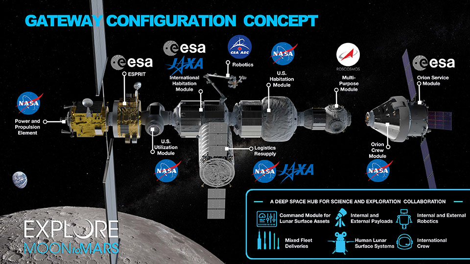
Map of the modules for the proposed Lunar Orbital Platform-Gateway station, to operate on the Moon and obtain construction within the 2020s. (Image: NASA)
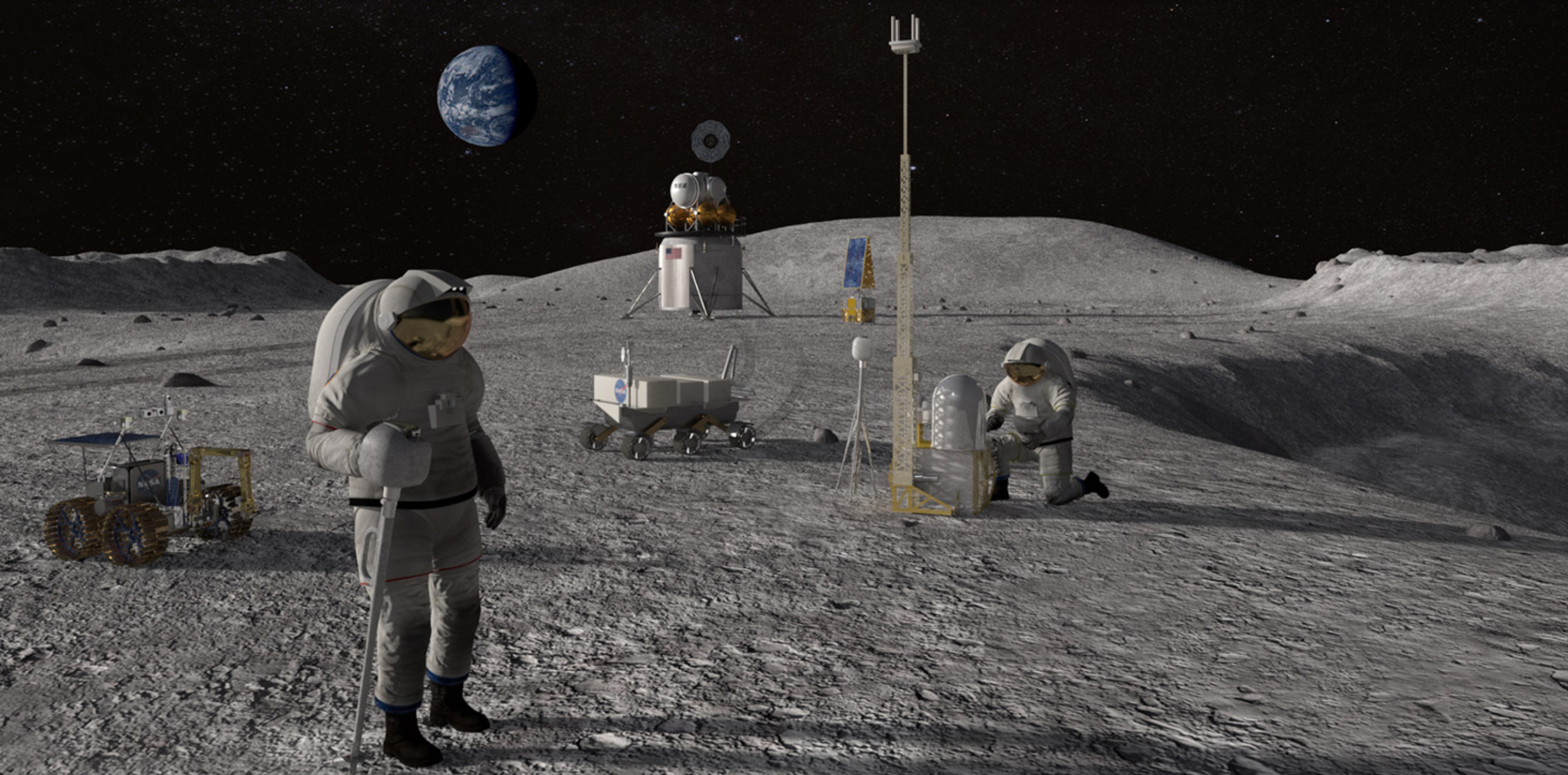
Activities related to international lunar exploration and development are increasing, including the United States-led international Artemis Program, which plans for a manned lunar landing in 2025 and a manned Mars landing in the 2030s.
The Japanese government is participating in Artemis, joining other countries to build a lunar orbiting base named “Gateway.” Gateway will serve as a way station to support exploration of the lunar surface.
Feature image: Artist’s conceptualization of Artemis astronauts using lunar positioning and communications on the Moon. (Image: NASA/Resse Patillo)
UPDATE: Because of bad weather, the launch is now scheduled for Oct. 26 (Oct. 25, 18:45 p.m. PT).
The launch of the “QZS-1R”, the replacement for QZS-1 by H-IIA No. 44 scheduled for Oct. 25 is postponed as a result of weather assessment. New launch date is Oct. 26. #H2AF44
A successor to the first Quasi-Zenith Satellite System (QZSS) satellite is planned for launch from the Tanegashima Space Center on Monday, Oct. 25, from 11 a.m. to 12 p.m. Japan Standard Time (2-3 a.m. UTC).
Michibiki Unit 1 was launched on Sept. 11, 2010, and entered its quasi-zenith orbit 10 days later. QZSS began service in November 2018 with four satellites. The Japan Aerospace Exploration Agency (JAXA) plans to have seven satellites aloft by 2023.
The satellite, designated QZS-1R, will be carried aboard H-IIA rocket No. 44. The QZSS launch will be streamed live. The broadcast program will begin at 10:35 a.m. JST.
Local launch times
Houston: Sunday, October 24, 21:00 New York: Sunday, October 24, 22:00 London: Monday, October 25, 03:00 UAE: Monday, October 25, 06:00 Singapore: Monday, October 25, 10:00
To follow upcoming GNSS satellite launches, see our launch table, provided by Innovation editor Richard Langley.
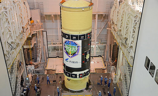
H-IIA Launch Vehicle No. 44 at the Yoshinobu Vehicle Assembly Building, JAXA Tanegashima Space Center. in preparation for launch of the successor to the Michibiki Unit 1 on Oct. 25. (Photo: MHI)
Shinichi Nakasuka, professor at the University of Tokyo Graduate School of Engineering and member of the Cabinet Office Space Policy Committee, released the following statement about the upcoming launch.
“Three years after the full operation of the four-machine Michibiki started in 2018, as the chairman of the Quasi-Zenith Satellite System Business Promotion Committee of the Cabinet Office, we strive to ensure the reliable operation and expansion of the use of this world-class system.
“I feel that high-precision positioning and two-way communication services in the event of a disaster, which cannot be achieved by GPS alone, are gradually taking root as social infrastructure. In modern society, the provision of highly accurate position and time is exactly the infrastructure that is indispensable as the ‘nerve network’ of society.
“To make that more reliable, the successor to the first machine, which pioneered this system, is about to be launched. We pray for the success of the launch and satellite operation, and hope that the Quasi-Zenith Satellite System will become more and more established in society, and that many people will be able to use this system for various purposes, including business.”
The successor to the first quasi-zenith satellite, dubbed Michibiki, is expected to launch this year.
Michibiki was launched by the Japan Aerospace Exploration Agency (JAXA) in September 2010 and was transferred to the Cabinet Office in 2017. The replacement satellite is now undergoing prototype testing at the satellite manufacturer’s facility(Mitsubishi Electric Co. Ltd. Kamakura Seisakusho) in Kanagawa.
The tests will confirm performance of the replacement satellite before it is put into service. It is undergoing acousitic, vibration and thermal vacuum tests to ensure it will remain functional after launch and in space.
After testing, the satellite will be transported to the Tanegashima Space Center for launch, which is expected to take place later this year.
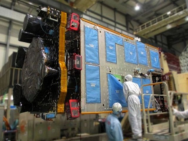
Replacement for Michibiki: The L-band antenna that transmits the positioning signal is mounted on the Earth-oriented left side. (Photo: JAXA)
Though built to succeed the first QZSS satellite, the replacement is based on the second and fourth satellites
Main specifications of the successor to the first satellite and other satellites:
item
First machine
Units 2 and 4
Unit 3
Successor to the first machine
Orbit
Quasi-zenith
Quasi-zenith
Rest
Quasi-zenith
Positioning signal
L1-C / A,
L1C, L1S,
L2C, L5, L6
L1-C / A, L1C,
L1S, L2C,
L5, L5S, L6
L1-C / A, L1C,
L1S, L1Sb, L2C,
L5, L5S, L6
L1-C / A
(L1-C / B (* 1)),
L1C, L1S, L2C,
L5, L5S, L6
L band antenna
Helical method
(* 2)
Helical method
(* 2)
Patch method
(* 3)
Patch method
(* 3)
Generated power
5.3kW
6.3kW
6.3kW
6.3kW
mass
About 4t
About 4t
About 4.7t
About 4t
Design life
10 years or more
Over 15 years
Over 15 years
Over 15 years
Launch year
2010
2017
2017
2021
(planned)
Launch
rocket
H2A202
H2A202
H2A204
H2A202
(* 1) Signal transmitted by BOC (Binary Offset Carrier) modulation of L1-C / A code
(* 2) Antenna with spiral antenna elements arranged
(* 3) Antenna with planar antenna elements arranged
This month we bring you a guest column by Steffen Thoelert, André Hauschild, Peter Steigenberger and Oliver Montenbruck of the German Aerospace Center (DLR) and Richard B. Langley of the University of New Brunswick.
UPDATE:Since Sept. 10, continuously operating DLR receivers in Sydney, Australia, and Chofu, Japan, have been reporting measurements from QZSS satellite J07, which, according to the QZSS Interface Control Document, is the geostationary satellite QZS-3.
The second satellite of Japan’s Quasi-Zenith Satellite System (QZSS) has started transmitting navigation signals. QZS-2, or Michibiki-2, was launched on June 1, 2017, and joins its predecessor QZS-1 (Michibiki-1), which has been in orbit since September 2010.
Both satellites have been placed into inclined geosynchronous, elliptical orbits, which enable extended satellite visibility periods over Japan and are characteristic features for this regional navigation system.
The third satellite, QZS-3, was launched on Aug. 19, 2017, into a geostationary orbit. If all goes according to plan, a fourth satellite in an eccentric orbit will follow by the end of this year and complete the constellation.
QZS-2 Signal Tracking
It is not straightforward to tell when QZS-2 started signal transmission exactly. About four weeks after launch, on June 27 between 10:17 and 12:37 UTC, several Septentrio PolaRx GNSS receivers in the Asia-Pacific region recorded continuous L5 observations. About one week later, on July 4 shortly after 03:02 UTC, Javad and Trimble receivers picked up L1 C/A and L5 signals from QZS-2 for a few seconds. Then again, between 23:03 UTC on July 6, and 01:36 UTC on July 7, several receivers intermittently tracked the L1 C/A, L2C and L5 signals. Finally, on July 10, starting at approximately 01:03 UTC, these three signals were continuously tracked until approximately 04:00 UTC on July 12. Up until Aug. 1, signal tracking had remained intermittent, but has been stable since. This was presumably the result of interruptions in the signal transmission due to test activities.
Figure 1. QZS-2 signals tracked by GNSS receivers in Chofu, Japan, (top plot) and Sydney, Australia, (bottom plot). The plots depict the measured C/N0 for L1 C/A (black), L2C (red) and L5 (green) together with the observed pseudorange (grey). The frequent discontinuities in the pseudorange are due to the receiver clock adjustments. Both receivers exhibited a short tracking outage at approximately 06:00 UTC. The interruption in tracking at Chofu around 08:00 UTC is due to the low elevation angle of the satellite.
The plots in FIGURE 1 show QZS-2 signals as tracked by GNSS receivers in Japan and Australia on July 10. The two first sets of broadcast messages were transmitted on July 16 at 6:00 and 7:00 UTC. Regular transmission of broadcast ephemerides started on July 27 at 22:00 UTC, but deviations from the hourly update rate still occur from time to time.
Identical or Fraternal Twins?
At first glance, QZS-2 seems like a look-alike of QZS-1, but there are many differences between the two spacecraft. Most apparent is the presence of an additional auxiliary antenna. Like QZS-1, QZS-2 transmits its navigation signals on the L1, L2, L5 and L-band Experiment (LEX) frequencies through the main antenna, while the augmentation signal L1S (formally known as Submeter-class Augmentation with Integrity Function or SAIF) is transmitted from a separate antenna. However, the new L5S signal, which is introduced with QZS-2, is transmitted with yet another antenna.
The new satellite also has a shorter “wingspan” of only 19 meters, since it is equipped with two solar panel segments on each side, compared to three segments for QZS-1 with a width of 25.3 meters. The second QZSS satellite also follows a different attitude model: Unlike QZS-1, which switches between yaw-steering mode and orbit-normal mode depending on the sun’s elevation angle with respect to the orbit plane, QZS-2 always remains yaw-steering except for short periods of time when orbit maneuvers are performed. Further differences will become apparent in the analysis of the signal spectra in the subsequent sections.
The Cabinet Office of the Government of Japan, which oversees QZSS as a national undertaking, has published QZSS satellite metadata information on its official website. At the time of writing, only one document for QZS-2 is available, which contains information about the satellite’s properties such as mass, dimension, attitude law and reference frame, but also antenna and laser retroreflector positions, antenna phase-center offsets and variations as well as signal group delays.
Additional documents containing metadata for QZS-1, -3 and -4 and further information about QZS-2 are in preparation.
Rubidium Clock
FIGURE 2 illustrates the stability of the QZS-2 rubidium atomic frequency standard (RAFS) by means of the Allan deviation (ADEV). Data from a global network of 150 GNSS stations was processed to estimate GPS and QZSS satellite orbit and clock parameters.
Figure 2. Allan deviation of the rubidium atomic frequency standards of GPS Block IIF satellite G32, QZS-1 (J01) and QZS-2 (J02).
However, whereas about 60 of these stations provide QZS-1 observations, QZS-2 is only tracked by 13 stations. ADEV values for QZS-1, QZS-2 and a GPS Block IIF satellite were computed from a daily solution for Aug. 3 with 30-second clock sampling.
At an integration time of 100 seconds, the QZS RAFS reaches an ADEV of better than 3 × 10-13.
At longer integration times, the QZS-2 clock almost reaches the stability of the GPS Block IIF RAFS.
Based on this preliminary analysis for only one day, the QZS-2 clock seems to perform as expected. The larger ADEV values compared to QZS-1 for integration times up to 1,000 seconds might be attributed to the significantly smaller number of tracking stations contributing to the QZS-2 clock solution. The quality of the clock solution will improve as soon as more stations are able to track QZS-2.
Signals with High-Gain Antenna
Complementary to the receiver measurements and analysis, the German Aerospace Center (DLR) has also recorded raw spectral and in-phase and quadrature (IQ) data of QZS-2 to get further insights into the transmitted signal structure and initial signal quality. FIGURE 3 shows a spectral measurement of the complete GNSS L-band frequency range, which shows the signal transmissions of QZS-2 in the L1, L2, L5 and L6 bands. The signal was captured with DLR’s 30-meter high-gain antenna at Weilheim, southwest of Munich, operated by DLR’s German Space Operations Center.
Figure 3. QSZ-2 L-band normalized power spectra recorded at Weilheim, Germany, on July 18, 2017 at 20:43 UTC.
This first view of the signal transmission shows a good spectral shape, appropriate band filtering and no out-of-band unwanted spurious emissions of the satellite. For further analysis, we looked closer at each signal-band spectrum and performed IQ-sample recording.
Comparing the QZS-2 spectra to that of QZS-1, we see differences in the signal structure for the L1 frequency band.
Figure 4. QZS-1 and QZS-2 L1 spectral flux density.
FIGURE 4 shows the L1 spectra of both satellites. The additional signal component can be seen at an offset of 6 x 1.023 MHz and 18 x 1.023 MHz from the L1 center frequency of 1575.42 MHz. This is the result of the new L1C-pilot modulation, which is based on the time-multiplexed binary offset carrier (TMBOC) modulation technique using a mixture of BOC(1,1) and BOC(6,1). See here for detailed information.
Another difference is present in the L6 band and can be seen within the signal time domain or the IQ domain. The new satellite transmits two components (one each for the I- and Q-channels) while QZS-1 transmits only one I-component. This observation is fully in line with the QZSS Interface Specification. On QSZ-2, an additional L6 signal component (Centimeter-Level Augmentation Message for Experiments, L6E) is implemented. FIGURE 5 shows the IQ constellation plots of QZS-1 and QZS-2 for the L6 band.
Figure 5. L6 IQ constellation plots for QZS-1 (left) and QZS-1(right).
Source: GPS World
Furthermore, the L5 band IQ plot of QZS-2 exhibits significant differences compared to QZS-1. These differences, which are illustrated in the plots of FIGURE 6, are due to an additional L5S signal transmitted by QZS-2.
Figure 6. L5 IQ constellation plots for QZS-1 (left) and QS-2 (right).
Source: GPS World
The QZS-2 L5 IQ diagram is fairly easy to understand as a coherent superposition of two distinct quadrature signals from two antennas. One signal is the GPS-like L5 signal transmitted from the main L-band antenna, while the other (L5S) signal originates from a new L5S antenna. This is illustrated in FIGURE 7.
Figure 7. QZS-2 L5 IQ constellation plot including demarcation of the L5 and L5S signals.
For illustration purposes, the dashed orange square in Figure 7 relates to the 10 MHz L5 signal, while the smaller red squares are the 10 MHz L5S signal.
A code generator has been setup according the QZSS L5 and L5S interface control document (ICD). An analysis of the correlations of possible pseudorandom noise (PRN) codes resulted in the detection of PRN 194 and PRN 196. Based on the information in the ICDs, PRN 194 is used for L5 and PRN 196 is used for L5S.
The performed code correlation analysis also yields the finding that the L5 signal is approximately 3.5 dB stronger than the L5S signal. Note, however, that both signals have a specified minimum receive power of -157 dBW. Due to the limited visibility of QZSS satellites from the Weilheim ground station, it is not possible to verify this value.
Conclusion
With the launch and activation of QZS–2, the deployment of Japan’s regional navigation system is moving forward again. The launch of a geostationary satellite, QZS-3, took place on Aug. 18. A fourth Japanese navigation satellite is scheduled to launch later this year. With this rapid sequence, the target date of 2018 for the completion of an operational constellation with four satellites is quite realistic.
Steffen Thoelert, André Hauschild, Peter Steigenberger and Oliver Montenbruck are from the German Aerospace Center (DLR).
Richard B. Langley is from the University of New Brunswick and authors the monthly Innovation column for GPS World magazine.
Mitsubishi Heavy Industries Ltd. and the Japan Aerospace Exploration Agency (JAXA) successfully launched a second navigation satellite on June 1.
The H-IIA Launch Vehicle No. 34 (H-IIA F34) delivered into orbit Michibiki No. 2 of the Quasi-Zenith Satellite System (QZSS) at 9:17:46 a.m. (JST) from JAXA’s Tanegashima Space Center.
The launch and flight of the rocket proceeded as planned, and the separation of the satellite was confirmed 28 minutes and 21 seconds after the launch time.
The Replicator by IP Solutions is a multi-frequency, multi-system GNSS simulator for advanced research and development, equipment testing and education. It can also function as a recording, playback and signal analysis instrument.
IP Solutions is exhibiting this week at ION GNSS+, in Portland, Oregon.
The Replicator is the result of a collaboration with the Japan Aerospace Exploration Agency (JAXA).
Components include the Simceiver hardware device, the ReGen control software for real-time simulation, Streamer control software for recording and playback, and ARAMIS software receiver for signal analysis.
The 24-channel Replicator provides real-time generation of GNSS signals, recording and playback of dual-frequency GNSS RF signals, and GNSS RF signal analysis with JAXA COSMODE ionospheric scintillation monitor.
The Replicator offers real-time simulation of dual-frequency GPS, GLONASS, BeiDou or GPS+GLONASS, GPS+BeiDou, GPS+Galileo signals.
Comprehensive simulation models include atmosphere, multipath, and more. Also available is signal analysis based on JAXA COSMODE ionospheric scintillation monitor.
Two or more units can be used to simulate, record and playback more signals at the same time. Simulated and recorded signals can be stored in digitized format, analyzed by a MATLAB software receiver and played back as RF at any time.
Replicator Advantages
User defined models with ANSI C API
Real-time simulation
Record and playback
GNSS signal analysis
Upgradable to more features , signals and frequencies for the difference in price.