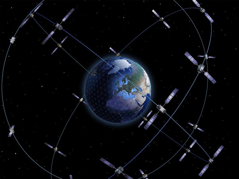
The European Space Agency (ESA) and the European Commission’s Joint Research Centre (JRC) are collaborating to host the 15th edition of the International Summer School on Global Navigation Satellite Systems (GNSS).
The course is scheduled to take place in Novo Mesto, Slovenia, from July 15 to 26, 2024.
The summer school invites graduate students, Ph.D. candidates, postdoctoral researchers, engineers and academics from both the industry and agencies to attend. The wide range of attendees offers a dynamic environment conducive to learning and networking.
The deadline for registration is June 15. Those who register by April 15 will be offered reduced fees. Additionally, the ESA Education Office is offering up to four scholarships.
The comprehensive curriculum of the summer school encompasses all aspects of GNSS, starting from the fundamental principles of satellite navigation to recent advancements in positioning, navigation and timing services.
Participants will have the opportunity to learn from world-leading experts in the field, including ESA Director of Navigation, Javier Benedicto, former ESA Director General, Jean-Jacques Dordain and former ESA Director of Navigation, Paul Verhoef.
According to Rokubun — a Spanish company that designs accurate and scalable navigation solutions based on GNSS — released a library solution for decoding and processing Galileo Open Service Navigation Message Authentication (OSNMA) for embedded platforms.
The solution is part of the Horizon Europe BANSHEE project, for which Rokubun served as the coordinating, is EU-funded, and is supported by the European Union Agency for the Space Programme (EUSPA). The goal of the project was to develop a hybrid technology that combines Wi-Fi ranging and satellite navigation (including the Galileo OSNMA) to allow for accurate and seamless indoor-outdoor navigation.
The upcoming Galileo OSNMA will provide authenticated navigation data message against data-level spoofing attacks. By delivering data authentication, the free-to-use Galileo OSNMA assures users that the received Galileo navigation message comes from the system itself and has not been modified by, for example, a spoofing attack.
To address this risk, Rokubun’s library enables the Galileo OSNMA in embedded GNSS solutions. The cross-platform, small-footprint library has undergone extensive testing using official EUSPA test vectors, and all OSNMA algorithms have been validated in real conditions at the European Commission’s Galileo testing facilities located at the Joint Research Centre in Ispra, Italy.
The library is organized to be portable, requiring only a working assembler and C compiler that supports ISO C99. To ensure optimal performance and validate user-specific enhancements, such as the utilization of cryptographic accelerators or other system-on-chip/microcontroller specific resources, Rokubun has implemented a hardware-in-the-loop continuous integration/deployment setup.
This setup continuously tests the library against several reference MCU targets, assessing its performance and guaranteeing its reliability.
An exclusive interview with Dr. Michael O’Connor, CEO, Satelles. For more exclusive interviews from this cover story, click here.
How many Iridium satellites carry your system?
Mike O’Connor
Iridium has 66 active satellites. There are also several spares on orbit. The satellites were all launched between 2016 and 2018, so they are all relatively new. They cover the entire globe, 24 hours a day, seven days a week, so they have universal coverage.
How will your constellation grow?
Today, our Satellite Time and Location (STL) service is offered only over the Iridium satellites. There’s nothing else that we’re discussing publicly. It could expand over time to other satellites. The signal and the capability are flexible. In terms of how Iridium could change, that’s more for Iridium to discuss than us.
Who makes chipsets that can use your system? And how does that work?
We work with partners. For example, with Adtran (through their Oscilloquartz product line), Jackson Labs (now VIAVI Solutions), Orolia (now Safran Trusted 4D). Companies like that provide the solutions that are favored by critical infrastructure providers today. We provide them either reference designs or effectively referenced designs. They ultimately integrate our STL capability into their solutions. We help them to do that. They can use our reference designs or create their own custom designs based on our reference designs. So, that’s the model that we use.
Is the STL receiver on top of a traditional GNSS receiver and passing certain data to it?
STL is used in two ways. In some cases, users are trying to do positioning or timing in an environment where GNSS signals will not reach, such as indoors, or are otherwise unavailable. In those cases, it wouldn’t be overlaid with GNSS, it would just be a standalone solution.
In many other cases, the goal is having a solution that is resilient to an outage, interference, jamming, spoofing, those sorts of things. In that case, the receiver card that might be provided by one of our partner companies would have both GNSS and STL capabilities and would take the best of both worlds. If GPS is jammed or there’s interference, then the STL signal alone would be sufficient to do PNT. However, whenever both signals are available and can be authenticated, then it would use both and leverage the benefits of having two systems.
Does the location calculation take place in a GNSS chip or separately in the STL?
The chain to take measurements of the STL satellite signals is different. It’s not a single chip that’s measuring both satellites, it’s ultimately two chips that are making those measurements. Then how the position calculation and the integration of those signals is done is left to our partners. In some cases, it is proprietary to the partners that are doing that integration work. It can be integrated loosely or tightly.
When it’s just the STL chip, is that usually for timing purposes, or both timing and location?
Generally, an STL-only solution is best suited for timing. It’ll do timing at about 100 ns, depending on what kind of oscillator is being used and the exact configuration of the product.
What positional accuracies can you achieve?
Generally, in the 10 m to 20 m range, depending on the product configuration.
Most of the correction services refer to variables that are not relevant to your system.
That’s right. There are other techniques, such as integrating with other sensors, that can improve the accuracy. The primary uses for STL today are in delivering timing in environments where GNSS is not able to do so today, such as for national critical infrastructure. That’s been our commercial focus as a company.
Who currently uses the STL receivers? Which markets are you targeting first?
Most of our users are in the data center space. Stock exchanges around the world are also using our service as a source of resiliency, and now wireless infrastructure. So, think 5G infrastructure. As 5G networks are rolling out, they need about five to ten times more nodes to cover a geographic area than 4G networks. GNSS has been used for years to time 4G networks, but most 5G network sites — such as femtocells and picocells — are indoors or in places where GNSS is challenged. We deliver that timing service indoors, outdoors, everywhere. So, those are the three commercial markets where we have the highest adoption rates.
You still have plenty of room for expansion in that market before you must start thinking about expanding into other areas.
Yes, there’s plenty of room for expansion into those markets, so I wouldn’t say that they’re fully saturated. We are also looking into other opportunities. We’ve seen interest in the energy area. I think the industry is a little bit slower moving, but the need is ubiquitous, right? We all recognize that a black swan event in our society would really represent a bad day and we want to avoid that.
There are several companies across the industry that are trying to solve that important problem. Everyone involved in critical infrastructure that requires a timing reference — which is anything that is associated with a network activity — should have an alternative or augmentation to GNSS as a timing source. It’s great that we’re seeing tailwinds from the U.S. Government, from the European Union, and from others to try to encourage that adoption. However, there’s still a long way to go before we really feel that that’s been sufficiently covered.
What, if any, have been the major developments in the past year or so?
One of the most interesting things that has happened over the last year and a half has to do with our capability regarding STL. We’ve been demonstrating more publicly, and with more independent authorities, the capabilities, resiliency, and operational characteristics of our service.
For example, the JRC study.
It started with the U.S. Department of Transportation (DOT) a couple years ago, but there’s also been some work done by the Department of Homeland Security and with the National Institute of Standards and Technology (NIST). We’ve been working directly with NIST to do some validations, as well as with UK and European organizations. They have subjected STL to rigorous third-party, hands-off technology evaluations. They confirmed the timing accuracy specifications to UTC and validated the operational characteristics of STL, such as the resilience in the absence of GNSS, the ability to receive the signal indoors, and having global availability.
We’re delighted to see the third-party operational evaluation of things that we’ve known all along but are now being evaluated and confirmed by these government sources. Beyond that, of course, there are always going to be technology advancements, both with our company and with other companies.
The real focus of industry right now is on adoption. All the providers of these capabilities ultimately need adoption in industry to remain active and viable. These are good people trying to do the right thing to protect our society. There are many great technology solutions out there to do it. Hopefully, many of these solutions are adopted in the near term. That’s what our focus has been. Our focus has not been on squeezing an extra five nanoseconds out of performance, although, of course, we’re always doing that. I think the important focus of industry should be driving adoption. There are solutions available today, including ours, that are ready to go and are being proven operationally in use.
Can you say more about the study by the European Commission’s Joint Research Centre (JRC)?
If you look at the summary, all these technologies that were demonstrated worked. Both the DOT report and the JRC report effectively summarize that there are multiple technologies out there today that are ready to go.
The Safran Navigation & Timing critical infrastructure solution, White Rabbit, has received high praise in a report published by the European Commission (EC) Joint Research Center (JRC) that evaluates the effectiveness of alternative positioning, navigation and timing (APNT) platforms.
For more than eight months, the commission studied a variety of available solutions to assess the performance of APNT demonstration platforms in a variety of situations where there is signal loss, and a backup system is necessary. The selected solutions were evaluated for precise and robust timing and positioning services in challenging indoor and outdoor environments.
Safran’s White Rabbit is a high-accuracy time and frequency distribution protocol, which combines precise time protocol (PTP) packets with the frequency base of Synchronous Ethernet (SyncE) to provide sub-nanosecond time transfer accuracy over an optical fiber. While the results of the test campaign showed that all APNT platforms under evaluation demonstrated performances in compliance with the requirements set, White Rabbit excelled in its performance.
Safran demonstrated White Rabbit’s ultra-accurate time transfer over fiber optics, its high-performance time generation, resiliency (based on failover and holdover), interoperability, and user-friendly monitoring capabilities.
As stated in the report, Safran demonstrated, “the ability to handle multiple master clock inputs with voting and seamless switchovers. Interconnecting as many NMIs as possible, with possible local atomic clock backups, would result in a very robust and resilient time architecture, independent from GNSS across Europe. The ability to provide resilient and accurate time through the EU communication infrastructure, ideally on the nanosecond level, would also enable robust positioning, using a combination of signals.”
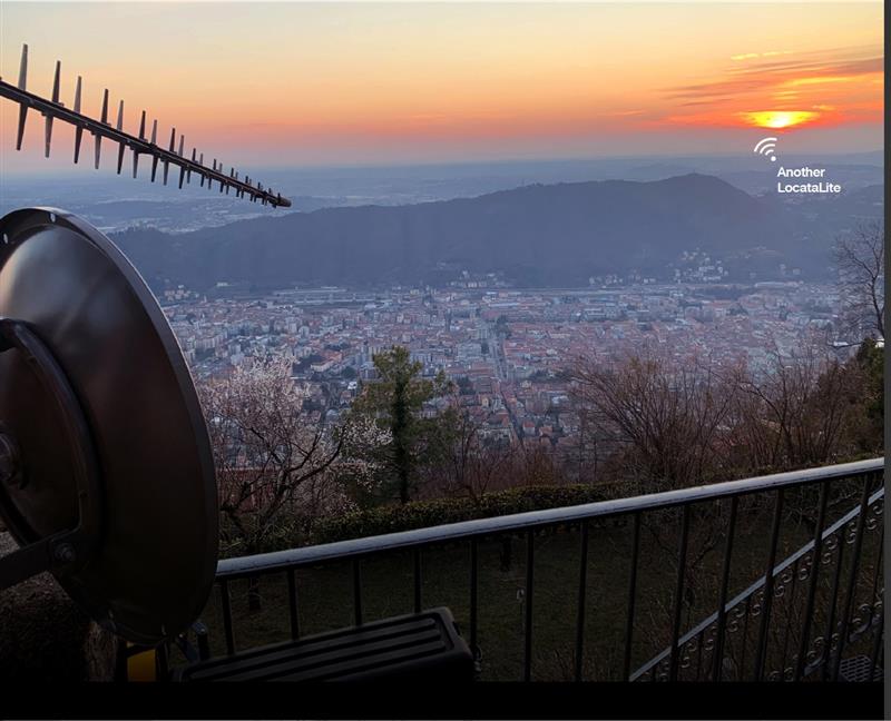
Locata dish antenna pointed back to EU’s JRC, 44 km away, just under the setting sun. The Yagi antenna above is pointed to a cell tower in Como and used to connect the system for remote control and data logging. Image: Locata
A new European Commission (EC) Technical Report, published after exhaustive and completely independent testing of several candidate A-PNT (Alternative Positioning, Navigation, and Timing) technologies, confirms that Locata has demonstrated positioning and timing performance across every test environment, delivering:
cm-level positioning accuracy in all tests, indoor and outdoor, under static and kinematic conditions
picosecond-level time transfer using Locata’s proprietary TimeLoc technology, over multiple media types including RF over distances of more than 105 kilometres and over fibreoptic and/or coaxial cables, without requiring satellites or atomic clocks.
The rigorous scientific test campaign was conducted over a period of eight months by experts from the EC’s Joint Research Centre (JRC) in Italy. Its purpose was to establish the foundations for European navigation and timing policy, including the upcoming European radio navigation plan, in the context of growing concerns about the single-point-of-failure that GPS and other Global Navigation Satellite Systems (GNSS) pose.
According to Locata, their validated capabilities promise to open previously unattainable, satellite-free A-PNT performance for autonomous vehicles, logistics, indoor positioning, critical national infrastructure, and aviation, as well as better levels of synchronization to improve mobile phone and digital data networks.
Locata’s products have been deployed commercially for a decade, delivering cm-level positioning (via sales and IP licenses) to globally recognized partners, including systems now certified for safety-of-life level operation of autonomous vehicles. Prominent government customers include NASA and the United States Air Force, which runs a large Locata network that covers more than 6,500 sq km for aviation use when GPS is being jammed or spoofed.
This performance evaluation assessment was run under a globally-open tender launched by the EC’s Directorate-General for Defence Industry and Space (DEFIS). The tender sought applications from around the world, from every potential candidate claiming they could provide “an alternative to GNSS-based PNT.” More than 30 companies applied, and this number was then down-selected by an expert panel to the seven technologies that were, in the end, independently evaluated. Locata was the only technology that was granted two contract slots, and the only technology that completed every timing and positioning test, in every indoor and outdoor environment, sought by the EU.
The European Space Agency (ESA), in collaboration with the Joint Research Centre of the European Commission, are hosting this year’s ESA/JRC International Summer School on GNSS with the Swedish Space Agency in July in Kiruna, Sweden. The course will include an overview of satellite navigation from the theoretical basis of GNSS, their signals, and processing by receivers and more.
Elements of this year’s program will include details of low-Earth-orbit positioning, navigation and timing, navigation on the Moon, and Galileo’s Open Service Navigation Message Authentication. Exercises will include receiving signals from Galileo and other GNSS.
Participants will also learn about business aspects, intellectual property rights, and the future of satellite navigation systems, including Galileo second-generation.
Some of the world’s leading satnav and space experts will be giving lectures. Lecturers include Paul Verhoef, former director of navigation for ESA, and Jean-Jacques Dordain, former director general. The course will be opened by Anna Rathsman, Director General of the Swedish National Space Agency; Javier Benedicto, Director of Navigation at the European Space Agency; and Georgios Giannopoulos, head of the Technologies for Space, Security and Connectivity Unit at the Joint Research Centre of the European Commission.
The course is limited to 50 participants on a first-come, first-served basis and is open to graduate students, Ph.D. and postdoctoral researchers, as well as young engineers and academics working within industry or agencies, aged 38 or younger.
The summer school will take place July 17-28 in Kiruna, Sweden. Register before April 14 for a reduced early fee. For more information and to register, click here.
NextNav participated in the European Commission’s Joint Research Centre (JRC) alternative positioning, navigation and timing (APNT) evaluation in Ispra, Italy. At the trial, NextNav showcased an alternative PNT backup to GNSS, TerraPoiNT.
According to the JRC, the trial is analyzing the technologies “which could deliver positioning, and/or timing information, independently from GNSS, to be effective backup in the event of GNSS disruption, and if possible to be able to provide PNT in the environments where GNSS cannot be delivered.”
The test furthers the European Union’s creation of a backup to GNSS and is intended to assess which technologies could strengthen and expand the European PNT capacity.
PNT services are critical for the global economy, with studies estimating a contribution to the European GDP of approximately 10%. Today, GNSS services are the backbone of PNT, with an increasing role in new services and technologies, including car-sharing, autonomous vehicles, ship and aircraft navigation, smart logistics and precision agriculture.
It’s About Time
The timing capabilities of PNT are heavily utilized today by critical infrastructure, which is strategic from a commercial and societal perspective, including telecom, energy, finance and transportation. Published studies estimated economic losses of around 1 billion EUR per day if GNSS were unavailable.
NextNav’s TerraPoiNT trial focused on measuring the precision of timing delivery across alternate timing sources to better understand performance in GNSS-free environments — including instances of outages, spoofing and jamming. As a part of the trial, NextNav also demonstrated its capabilities in providing both indoor and outdoor z-axis vertical location.
TerraPoiNT is a system for assured PNT that uses terrestrial transmitters deployed around a service area to triangulate the location of a device. Unlike national space-based systems, the proximity of NextNav’s transmitters makes the signal strength 100,000 times that of GPS.
“The trials are part of the global trend to develop a resilience layer to space-based GPS/GNSS systems that is more secure and available,” said Ganesh Pattabiraman, NextNav CEO. “We are redefining the capabilities of APNT technologies and look forward to working with the European Commission on furthering these initiatives to build a GNSS backup layer that can deliver highly precise PNT across use-cases.”
Trials for U.S., Europe
The U.S. and countries across Europe continue to invest in both understanding and taking steps towards creating a resilient PNT layer in each nation. Participation in the JRC trial builds upon the recent evaluation of APNT technologies in the United States, including a 2021 U.S. Department of Transportation report, where TerraPoiNT was found to be the best performing APNT solution across use cases.
Further, NextNav recently created an APNT testbed in the San Francisco Bay area that was developed as part of a U.S. Department of Homeland Security demonstration used to evaluate the precision and resilience of NextNav’s TerraPoiNT network.
The JRC is expected to report results from the evaluation this spring.
A version of the NeQuick G algorithm using a new coding approach is now available for download on the GSC website. This version is the result of intensive recoding by engineers at the EU’s Joint Research Centre.
GNSS signals traveling through the ionosphere can be significantly delayed by the electrical charges in this atmospheric layer before reaching the users’ terminal. To compensate for this delay in the signal, Galileo receivers integrate a dynamic model of the ionosphere composition known as the NeQuick G model.
Receiver manufacturers will now be able to benefit from a version of the NeQuick G correction algorithm that implements a new coding approach.
Rigorous testing
The JRC concluded its work recently after successful rigorous testing in the framework of the gLAB tool (GNSS software suite from the Universitat Politecnica de Catalunya). This version of the code has been designed to be highly modular, rendering it more legible for a potential programmer with no specific knowledge about signal propagation in the ionosphere. A library has been also developed to enable its quick integration into existing applications.
This software will be released as free and open source software under the terms of the European Union Public Licence (EUPL), version 1.2.
The open-source code is now ready to be implemented on single-frequency platforms and can be used on a global scale without limitation under the EUPL. This freedom should contribute to a wider adoption of the NeQuick G model at user level.
Spirent Communications plc is working with the European Commission’s Joint Research Centre (JRC) to help implement the eCall system, which is required in new cars sold in Europe starting in April.
Experts from the JRC have been working with Spirent GNSS test equipment during the European GNSS Agency (GSA) eCall test campaign. The campaign aims to pre-test eCall in-vehicle modules and evaluate their compatibility with the positioning services provided by Galileo and the European Geostationary Navigation Overlay Service (EGNOS) in accordance with the test procedures established by the regulation.
As the eCall initiative goes live this month, the GSA launched a test initiative to support eCall device manufacturers in their preparation for type approval. In safety-critical situations, eCall must be as accurate as possible, so defining and conducting proper test procedures is imperative.
Spirent is cooperating with the JRC to develop its own eCall test solution. “Working with JRC enabled us to develop better tests to verify that eCall devices are working properly,” said Steve Hickling, product director for Spirent’s positioning business.
When a collision occurs, an eCall-equipped car automatically calls the nearest emergency centre. Even if no passenger is able to speak – such as because of injuries — a “minimum set of data” is sent, which includes the exact location of the crash site. eCall is expected to significantly reduce emergency service response times, leading to lives saved and injuries reduced.
The JRC used a Spirent GSS9000 simulator to assess eCall devices’s capability to support the reception and processing of the Galileo and EGNOS signals. Using feedback from the JRC, Spirent has developed an eCall Test Suite for its automation solution, PT TestBench.
Tested with various eCall devices, the eCall Test Suite is available for eCall device manufacturers and include, among others, positioning accuracy, time to first fix, GNSS receiver sensitivity and reacquisition performance.
The 11-day event is open to graduate students that have studied more than three years; Ph.D. students and postdoctoral researchers younger than 35 years old; and young engineers and professionals in the industry who are less than 35 years old.
Participants will learn a comprehensive overview of satellite navigation, starting from the GNSS system, its signals, the processing of the observations in a receiver and determining the position-navigation-time solution. They will be able to work hands-on in JRC labs and attend lectures on intellectual property rights, patents, business insights and the future of satellite systems.
There also will be a comprehensive group project, where participants will use their innovative ideas to develop a product or service and create a business plan, technical realization and marketing of that product or service.