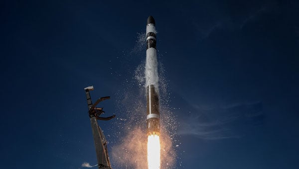
The European Space Agency (ESA) has selected Rocket Lab Corporation to launch a dedicated Electron mission, marking the first time the company will deploy satellites for ESA’s next-generation navigation constellation, low-Earth orbit positioning, navigation and timing (LEO-PNT). Thales Alenia Space and GMV, two European satellite prime contractors, are providing the “Pathfinder A” spacecraft for the mission. Rocket Lab plans to launch the satellites from Launch Complex 1 no earlier than December 2025.
The mission will place the two satellites in a 510 km LEO to test a new method of delivering location, direction and timing services from satellites in low orbit, known as LEO-PNT. ESA will use this demonstration to evaluate how a low Earth orbit satellite fleet can work with the Galileo and EGNOS constellations, which provide Europe’s global navigation system from higher orbits.
This contract highlights Rocket Lab’s growing role as a launch provider for European constellation operators and demonstrates the Electron rocket’s strong reputation. Earlier this year, Rocket Lab deployed a full constellation of IoT satellites for French operator Kinéis and launched a global wildfire detection mission for Germany-based OroraTech. Since 2021, Rocket Lab has supported European satellite operators with Electron missions
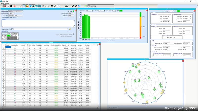
Syntony GNSS and Xona Space Systems have partnered to integrate the low-Earth-orbit (LEO) position, navigation and timing (PNT) constellation from Xona into GNSS simulators and receiver solutions from Syntony.
This partnership is part of Syntony’s and Xona’s strategy to offer users PNT solutions.
“The demand for advanced and resilient PNT services is skyrocketing,” Brian Manning, CEO of Xona Space Systems, said. “We are building an entire ecosystem from the ground up to address this demand. Having a full Rx-Tx solution available for all Xona signals is one of the keys to rapidly develop this LEO PNT ecosystem.”
Syntony GNSS was the first PNT services provider to integrate all of the Xona demo signals into its multi-GNSS simulation solution, Constellator, in 2022. However, to offer a full testing solution, Syntony has also developed a Xona-enabled GNSS receiver.
Adtran and Satelles, a provider of secure time and location technology using low-Earth-orbit (LEO) satellites, have partnered to offer operators of critical infrastructure a timing network device with satellite, time and location (STL) technology. The partnership aims to provide an alternative to GNSS by integrating STL technology from Satelles into Adtran’s Oscilloquartz network synchronization products.
Through its partnership with Satelles, Adtran’s Oscilloquartz division will incorporate STL into its end-to-end timing toolkit. The companies will also integrate STL into its grandmaster clocks to develop miniature M.2 form factor STL receiver modules for third-party product integration.
With the ability to deliver precise position, navigation and timing (PNT) service in GNSS-denied applications, STL is suitable for mobile operators, power utility companies, government, scientific research and more. STL technology also offers accurate, secure and augmented Iridium LEO-based PNT services for indoor applications and as backup for GNSS outdoors.
Artists rendering of the B-21 raider, which is being produced by Northrup Grumman for the U.S. Air Force to operate in tomorrow’s high-end threat environment. (Image: U.S. Air Force)
With assured positioning, navigation and timing (APNT) and low-Earth orbit PNT (LEO PNT) coming on strong, what does the future hold for military and commercial systems dependent on the current configuration of GPS? Should military and commercial platforms be modified to include APNT, for now, with an eye to adding LEO PNT in the future? Should they integrate these two systems, or rely on one or the other as standalone systems?
Government and industry agree that interference with GPS and all GNSS is an increasing threat as jamming and spoofing technologies evolve. This has prompted government support for APNT to bolster GPS. A Feb. 12, 2020, Executive Order required a comprehensive update to national policy on PNT services by the federal government, and by owners and operators of critical infrastructure to strengthen the resilience of critical infrastructure.
Research, development and production have improved the performance — positioning, timing and (desired) accuracy — of GNSS PNT and the ability to operate in RF-challenged environments. APNT gives the U.S. military a reliable way to further enable GPS, or to act as an alternative to it, by utilizing other sensors, such as inertial navigation systems, differential GPS, visual sensors, lidar, radar, radios and star trackers that complement GPS.
The near-term expansion of internet service to include commercial broadband LEO satellites also provides potential for robust PNT, using their waveforms as signals of opportunity (SOOP). GPS and other GNSS have an infrastructure to maintain very precise time throughout their constellations, as well as satellites with specially designed transmitters, clocks, and a waveform dedicated to the PNT function. By contrast, SOOPs are in space for another purpose and not optimized for PNT. Therefore, the challenge is to exploit features of the SOOP waveforms, designing innovative techniques to determine the range to each satellite and to provide users with reliable PNT. The approach for LEO PNT may have applications to ground troops and for aerial, munition, missile and commercial applications requiring higher levels of PNT security and integrity.
GPS receivers for future military platform designs may use a software defined radio (SDR) approach and be capable of incorporating LEO PNT signals. This technology, although designed to work standalone, can be used to complement existing navigation sensors that are typically used in navigation systems, including APNT. Expansion to the usage of multiple constellations will serve to optimize performance and resiliency in an RF-challenged environment. However, LEO satellites’ closer proximity to Earth and their signal structures allow for higher signal powers, thus are more robust against jamming. With all these separate systems or fusion by SDR, how does the receiver ensure the integrity of the signal or its accuracy? An SDR qualification test would involve an unlimited number of scenarios.
One hallmark of the GPS program is that it facilitates a thorough systems engineering effort by managing in a single location interface control documents (ICDs) for alternative systems being developed by different program offices all over the country. This makes both the integration of the systems and the development of the receivers extremely difficult and complex.
“The new SPD-7 [Space Policy Directive 7, the United States Space-based Positioning, Navigation and Timing Policy, dated Jan. 15, 2021] focusing on interoperability and APNT is a seminal document to address a realized threat and a way forward,” said Bernie Gruber, a former head of the GPS Directorate (now the Military Communications and PNT Directorate). “To that end, the combination of SDRs and data fusion potentially offer a clear advantage to utilize signal and sensor diversity, thus improving the robustness of critical PNT information.”
The European Space Agency (ESA), in collaboration with the Joint Research Centre of the European Commission, are hosting this year’s ESA/JRC International Summer School on GNSS with the Swedish Space Agency in July in Kiruna, Sweden. The course will include an overview of satellite navigation from the theoretical basis of GNSS, their signals, and processing by receivers and more.
Elements of this year’s program will include details of low-Earth-orbit positioning, navigation and timing, navigation on the Moon, and Galileo’s Open Service Navigation Message Authentication. Exercises will include receiving signals from Galileo and other GNSS.
Participants will also learn about business aspects, intellectual property rights, and the future of satellite navigation systems, including Galileo second-generation.
Some of the world’s leading satnav and space experts will be giving lectures. Lecturers include Paul Verhoef, former director of navigation for ESA, and Jean-Jacques Dordain, former director general. The course will be opened by Anna Rathsman, Director General of the Swedish National Space Agency; Javier Benedicto, Director of Navigation at the European Space Agency; and Georgios Giannopoulos, head of the Technologies for Space, Security and Connectivity Unit at the Joint Research Centre of the European Commission.
The course is limited to 50 participants on a first-come, first-served basis and is open to graduate students, Ph.D. and postdoctoral researchers, as well as young engineers and academics working within industry or agencies, aged 38 or younger.
The summer school will take place July 17-28 in Kiruna, Sweden. Register before April 14 for a reduced early fee. For more information and to register, click here.
Jackson Labs Technologies PNT-6200 Series, an STL-based time and frequency reference system installed in a 5G application. Photo: Satelles
We discussed Satellite Time and Location (STL) services and complementary PNT with Michael O’Connor, CEO at Satelles.
What is the problem with GPS/GNSS that Satelles aims to solve?
GPS and GNSS are amazing. We designed Satellite Time and Location (STL), the service that we offer, to complement those capabilities. We have focused on three unique aspects in the areas where GPS could use complementary service. First, we provide a fully independent backup. We all know that things can happen, so we aim to provide an independent source of position navigation, and timing (PNT). Second, we focused the high-power aspect of STL to enable us to reach indoors and other places where GPS does not reach. Because STL comes from low Earth orbit (LEO) satellites, the signals are naturally at a higher power.
We also focused on improving the indoor penetration capability by enhancing the signal design and doing some other things. Third, we use modern cryptographic techniques to ensure the security and resilience of the system, specifically to intentional misdirection attacks. If you can ensure that the signal is coming from the satellite and not from a third party you can have a more secure and resilient solution.
To what extent can you replace GPS during an extended outage?
We have never considered LEO PNT as a replacement for MEO (medium Earth orbit) GNSS. GNSS are the primary domain of PNT but there are applications that have additional needs. The more independence you can get, the fewer the common modes of failure, if you can at least have some survivability in the absence of GNSS. That’s one of the services we can offer. It is probably not the most important thing to our customers, honestly. The service we offer is similar to GPS and GNSS in that we have a space segment (the satellites), a ground segment, and a user segment. We have space vehicles, user equipment, and ground infrastructure that supports the space infrastructure.
What’s interesting about the way we work with the Iridium satellite constellation is that the satellites themselves include inter-satellite links. That provides a lot of resilience to ground-based events. The satellites themselves have a time transfer capability between them. So, we don’t require a direct connection to every satellite to propagate a time throughout the network. That’s one unique aspect we can take advantage of with this particular network, Iridium, which is pretty amazing.
Additionally, we have multiple ground infrastructure and monitoring sites and multiple sources of time at those ground monitoring and control stations. For example, some of them rely on GNSS combined with atomic clocks as their master timing source but we also have one installed at the National Institute of Standards and Technology facility in Boulder, Colorado. So, we have multiple primary time sources that we can integrate into our filtering across the network. That, combined, with satellite links, allows us to maintain time for substantial periods independent of GNSS.
How do you define “complementary PNT” and how does Satelles fit in that mix?
Several applications have additional needs beyond what GNSS offer. There are many technologies that can come to bear on that. There’s the LEO satellite base, which is where Satelles fits in, but there are also local and wide-area terrestrial radio navigation sources, network-based time transfer, signals of opportunity, and so on. They all have something important to offer, depending on the application. Satelles’ LEO satellite solution is available today, has global coverage, and is relatively affordable. It leverages the capital investments that have been made to launch the satellites to provide this service globally. The industry is working together to make sure that an awareness of these capabilities is propagated throughout the industries that we serve.
Besides the orbit height, which requires many more satellites, how does your system differ from GNSS?
We do not consider LEO PNT as something that might replace MEO PNT. The fundamental difference is being in lower Earth orbit, which results in a higher received power. That is what allows us to penetrate, just based on the 1/r2 losses. The measurable Doppler signatures give additional observables for PNT calculations, and higher satellite dynamics that can help with multipath. This service relies on many of the same physics and geometry as GPS. We measure the time of arrival of a very similar signal. The signals from the Iridium satellites are even in the L band. Very often we’re using a GPS chip that’s been reprogrammed to track and utilize our service as well as GPS or instead of GPS.
If I explained how GPS works to, say, a high school science class, how much of that basic explanation—about trilateration, spread spectrum, etc.—would also apply to your system?
It’s fundamentally the same. It relies on a lot of the same physics and geometry. We measure the time of arrival of a very similar signal. The signals from the Iridium satellites are even in the L band. Very often we’re using a GPS chip that’s been reprogrammed to track and utilize our service as well as GPS or instead of GPS. There are subtle differences—for example, a lower Earth orbit is faster—but it is very similar.
How would GPS user equipment have to be modified to make use of your service?
We don’t think of STL as something where we are modifying GPS user equipment. Rather, we think about what must be done in an end-user application to meet their needs. For example, one of our partners, Orolia, has a GNSS + STL secure synchronization product that we have delivered to customers in data centers and major stock exchanges around the world. Those are operational and in service. They integrate through standard interfaces, such as PPS or PTP, depending on the type of equipment to which they are connecting.
Ultimately, we don’t think of it is as replacing GPS user equipment. Rather, where a user has a need for PNT, they’re opting for this GNSS + STL solution because they have an indoor need, such as a data center, or they have a need for resilience in the case of a stock exchange.
Another example is Jackson Labs. The Jackson Labs 2600 is also a GNSS + STL solution that generally is integrating with existing 5g. It has a specialized transcoder interface that can work with any existing GNSS-type equipment. In some cases, we’ve taken a chip that was originally designed for GPS and modified its firmware.
Who are the earliest adopters?
Satelles’ LEO satellite solution is available today, has global coverage, and is relatively affordable. It leverages the capital investments that have been made to launch the satellites to provide this service globally. Data centers, stock exchanges and cell phone providers are implementing these capabilities today. The major wireless operators are seeing that more and more of the 5G infrastructure they roll out is going indoors, where GPS doesn’t reach. We provide a solution that integrates with their existing solutions and can provide reliable timing capabilities.
If your solution can survive on its own, why does it need GNSS at all?
In some cases, the user is not using GNSS at all. The product itself has a GNSS capability. User equipment is very affordable and the service is taxpayer-funded. In many cases, especially for indoor installations, the equipment that is installed is capable of tracking GNSS and STL signals, but often it relies on the STL signal itself for timing.
How do you predict STL spreading through various applications and industries?
We have our hands full with the markets we’re going after now, but there are certainly going to be other markets in which the customers will recognize that they have a critical need to implement a backup solution.
In the long run, could LEO satellites replace MEO ones for GNSS?
Sometimes there have been misperceptions in the industry. I’ve never considered that LEO PNT satellites might replace MEO ones. There are excellent reasons why Brad Parkinson, Jim Spilker, Gaylord Green and others decided almost 50 years ago to put GPS in MEO. Those physics haven’t changed. You can cover a large portion of Earth with each satellite. LEO will not replace MEO, but it has unique characteristics that make it a great complement to the GNSS MEO solutions.
Do you have any additional comments about complementary PNT?
It’s good to see that the federal government is encouraging the adoption of complementary PNT, which they often call “GPS backup.” It is encouraging to see the amount of activity on this issue that’s been going in Washington over the last couple of years. Although our company is very focused on delivering a LEO-based PNT service, which has several advantages for customers that need a global capability, many technologies can play an important role in those solutions.
The U.S. Department of Transportation did a fantastic job of looking at several of those technologies across those different categories. The European Union has also had a similar activity recently. Some reports will be coming out soon about that. It is very important that the government understands that this is an important issue for our society and encourages industry to adopt these solutions and is even starting to make some investments toward that. That includes executive order 13905 and some recent funding increases by Congress.
All of that has been very important and positive, as has modifying some of the legislation to be more inclusive of multiple technologies, such as removing the words “land-based” from the National Timing, Resilience, and Security Act this year.
I am involved in an industry consortium, the Open PNT Industry Alliance, with several other companies whose CEOs are in alignment that there is no single answer. Having a thriving ecosystem of technologies and companies trying to solve this important problem is incredibly important and it’s exciting to see.
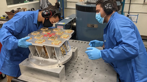
Xona has completed environmental testing for its upcoming demo mission, a significant step towards realizing its high-performance commercial navigation system
Xona Space Systems announced that their first in-space demonstrator has been delivered to Spaceflight Inc. for final integration after successfully completing testing and is scheduled for launch on SpaceX’s Transporter 5 in May.
Xona is an aerospace startup developing a precision navigation and timing system in low Earth orbit. It plans to build an independent high-performance satellite navigation and timing system to meet the needs of intelligent systems.
Xona’s first demonstration mission successfully completed testing at Experior Laboratories and prepares for launch on a Falcon 9 in May. (Photo: Xona)
Satellite navigation systems such as GPS and Galileo are in the domain of major governments (and free to users). Xona said it is part of the new commercialized space movement, using it to bring benefits to satellite navigation and timing.
Xona Space is launching Huginn, the first of two missions, demonstrating the capability of its Pulsar constellation. Pulsar’s architecture uses small, powerful satellites in low Earth orbit, more than 20 times closer to Earth than GPS satellites, which are in medium Earth orbit.
Pulsar is planned to deliver high-performance navigation and timing services by combining security and signal designs with Xona’s patent-pending distributed atomic-clock architecture to enable robust precision navigation services from low-cost satellites. Its precision LEO positioning, navigation and timing (PNT) service leverages advances in small satellite technology to provide users with a secure and robust alternative to traditional GNSS.
Xona’s system architecture utilizes the efficiency of small satellites to provide an affordable global system with more than 10 times better accuracy and 100 times better interference mitigation than legacy systems, the company claimed
Huginn will transmit the first precision navigation signals from a LEO spacecraft, designed to test and validate the core software and hardware technology that Xona has developed for Pulsar. The mission will also demonstrate the functionality of end-user equipment on Earth and supporting ground systems.
Huginn is now going through final integration with Spaceflight in preparation for launch on the scheduled Transporter 5 mission in May.
“We’re thrilled that Huginn has successfully completed its very rigorous test campaign in preparation for launch and are incredibly proud of the Xona team for achieving such a critical milestone,” said Brian Manning, CEO of Xona. “Through this process, we learned a massive amount and will be incorporating these lessons into our second demo mission as well as the production satellites.”
Following the Launch of Huginn, the Xona team will shift focus to the second demonstration mission as well as the development of the Block I Pulsar system.
The final Pulsar constellation will consist of several hundred LEO satellites, delivering secure and robust precision PNT services designed to meet the needs of advanced applications such as self-driving cars, precision agriculture and construction, augmented reality, critical infrastructure, and many others.
“It is inspiring to see what this team has been able to achieve going from a blank slate to orbit in less than a year from the time we completed our ground-based prototype testing,” Manning said. “This is a huge step in the development and deployment of our Pulsar constellation, and we’re looking forward to a very exciting year here at Xona.”
Xona is backed by Seraphim Space Investment Trust (LSE:SSIT) and MaC Venture Capital, with participation from Toyota Ventures, Daniel Ammann (co-founder of u-blox), and Ryan Johnson (former CEO of BlackBridge, operator of the Rapideye constellation). Follow-on investors also include 1517 Fund and Stellar Solutions.
Xona Space Systems fully funded for first LEO satellite navigation mission
Xona Space Systems is preparing for the launch of its first commercial positioning, navigation and timing (PNT) satellite, the first in a planned 300-satellite low-Earth orbit (LEO) constellation designed to cover the globe.
Xona has raised a new funding round co-led by Seraphim Space Investment Trust and MaC Venture Capital, with participation from Toyota Ventures, Daniel Ammann (co-founder of u-blox), and Ryan Johnson (former CEO of BlackBridge, operator of the Rapideye constellation). Follow-on investors also include 1517 Fund and Stellar Solutions.
Xona’s Pulsar precision LEO positioning, navigation and timing (PNT) service leverages advances in small satellite technology to provide users with a secure and robust alternative to traditional GNSS. The satellites will orbit 25 times closer to Earth than GPS satellites do.
Xona’s patent-pending system architecture makes use of the efficiency of small satellites to provide an affordable global service with 10 times better accuracy and 100 times better interference mitigation than the legacy systems, the company claims.
“We view global coverage of a safe, secure, and highly accurate navigation service as critical to the future of autonomy and countless other markets,” said Jeff Crusey, investment director of Seraphim Space Investment Trust. “We’re excited to continue supporting Xona because they’re an extremely talented and uniquely positioned team to execute on this plan.”
The funds raised this round will support the completion of Xona’s first orbital mission, scheduled for mid-2022, to demonstrate the capabilities of their Pulsar precision LEO PNT service.
Xona successfully tested its navigation system during a ground-based demonstration earlier this year, marking a major milestone for the company. It is now expanding laboratory facilities to support further development and enable on-site testing and manufacturing. This funding round will also provide for the growth of Xona’s technical team, which includes space and GNSS experts previously from NASA, Lockheed Martin, Maxar, L3 Harris, Blue Origin and SpaceX.
“Knowledge of location and time is one of the most fundamental aspects of both human life and machine operation,” said Brian Manning, CEO of Xona. “GNSS creates trillions of dollars of value by accurately answering the questions of ‘where am I?’ and ‘what time is it?’ for users all around the world. Xona was founded around the mission of enabling modern technology to operate safely in any environment, anywhere on Earth. To achieve this for both humans and machines, a foundation of reliable and accurate PNT is an absolute necessity, which is exactly what we are working to provide at Xona.”