Research drawing on data from Spire Global’s GNSS-R constellation has enabled the generation of Arctic-wide sea ice maps, marking a major step forward for GNSS-R. The research, enabled by the European Space Agency — suggests harnessing GNSS-R signals could become an important complement to established ice-monitoring altimetry missions. The study leveraged Spire’s GNSS-R data to retrieve sea ice freeboard measurements across an entire winter season. The results show strong alignment with established altimetry datasets, including the ESA’s CryoSat mission.
Russian jamming goes to the dogs
Credit: Marit Leinan Abrahamsen/Finnmarksløpet
Military jamming and spoofing from Russia’s Kola Peninsula interfered with GNSS trackers on dog sleds in Europe’s longest sled race, the 1,200- km Finnmarksløpet, held in Norway in March. The electronic warfare degraded GPS signals, forcing the mushers to rely more on trail markings and use traditional compasses and maps. Event organizers, who provided a live tracking system for fans, found it difficult to follow along, but the racers finished without incident.
Michigan Technological University is examining 11,000 historical images of the state’s Upper Peninsula to find precisely where each photographer stood to take the photo. According to university GIS data librarian Bob Cowling, the location will provide richer information about a place’s surroundings, especially if structures or environmental landmarks are no longer present. Donated historical images often arrive without any dates or location information attached to them. The project will make them easier to find on a map and make it possible to visualize what was there in the past.
In February 2023, a devastating 7.8-magnitude earthquake struck near the Türkiye-Syria border, followed by a second nearly as strong. Six Turkish universities have launched TR-TRAK-GNSS, a real-time geodetic monitoring network to trace earthquake-related ground deformation across Thrace and the Southern Marmara region. The 28-station system is expected to evolve into a major scientific and early warning system for earthquakes. Once fully deployed, it will form a continuous monitoring ring encircling Thrace and Southern Marmara.
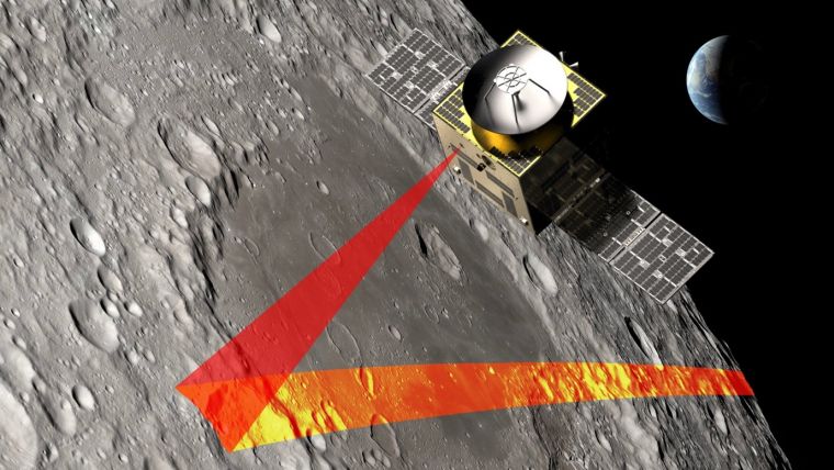
In recent years, scientists have shown that detecting changes in navigation signals from GPS and Galileo after they bounce off Earth’s surface (GNSS reflectometry, or GNSS-R) can deliver valuable information on sea ice. Now research drawing on data from Spire Global has enabled the generation of Arctic-wide sea ice maps, marking a major step forward for the emerging technique.
Spire Global‘s sea ice freeboard maps use data captured by Spire’s GNSS-reflectometry multipurpose listening constellation.
The research — enabled by the Third Party Missions (TPM) programme of the European Space Agency (ESA) — suggests that harnessing reflected navigation signals could become an important complement to established ice-monitoring altimetry missions.
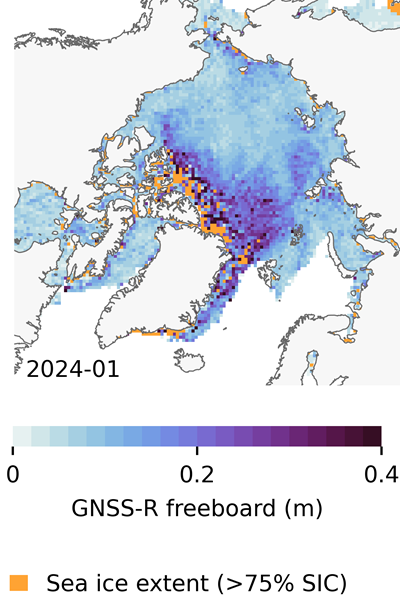
The study leveraged Spire’s GNSS-R data to retrieve sea ice freeboard measurements across an entire winter season. The results show strong alignment with established altimetry datasets, including the ESA’s CryoSat mission, validating the complementary role of commercial satellite data alongside government missions.
Arctic-wide sea ice freeboard map for January 2024. (Credit: ESA)
The study was led by Felix Müller at the Technical University of Munich (DGFI-TUM) and Robert Ricker at the Norwegian Research Centre, experts in GNSS-R.
“The primary purpose of signals emitted from GNSS is to fix the location of a device at any point on Earth,” Müller explained. “However, when these signals bounce off Earth’s surface, their properties change. By analyzing these changes, we can infer information about the characteristics of Earth’s surface.”
“Previous research has shown that this technique works well experimentally,” Ricker added. “Using the Spire constellation, we aimed to demonstrate whether it would hold up on a larger scale by generating an Arctic-wide map of sea ice freeboard, which is a measure of how far ice protrudes above the waterline.”
Spire’s GNSS-R constellation
Spire’s constellation was first used to sample the atmosphere for weather forecasting. Then scientists began exploring other applications. Spire started collecting reflected signals arriving at shallow angles using a technique called grazing-angle GNSS-R. This method is particularly well suited for ice monitoring.
The research team analyzed data detected over the Arctic Ocean and surrounding seas between October 2023 and July 2024. The data was obtained via the TPM program, through which ESA disseminates data from a range of commercial and institutional partners on a free basis for research and development purposes.
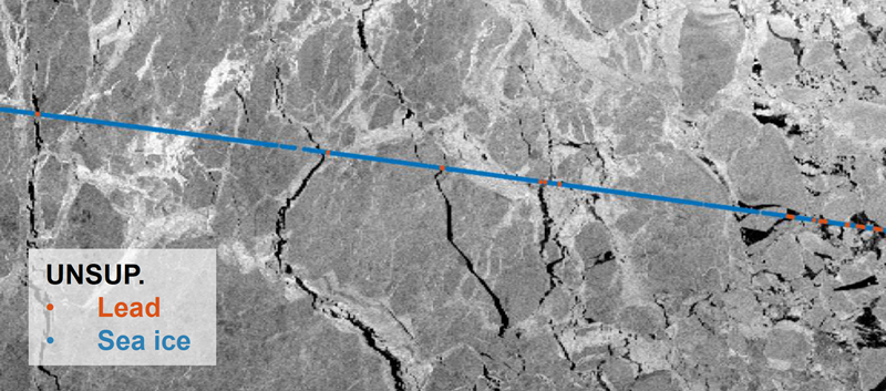
The team focused on one of the most critical challenges in sea ice altimetry: reliably identifying narrow openings in the ice pack, known as leads. These openings are reference points for determining sea surface height and, ultimately, sea ice freeboard.
In turn, sea ice freeboard can be used to infer sea ice thickness — an essential parameter for tracking climate change, estimating sea level, and modeling ocean and weather patterns.
Identifying leads in sea ice with GNSS-R data. (Credit: ESA)
Classifying surface properties
“In the initial phase of the project, we used two complementary methods to identify surface properties based on GNSS-R data, with the aim of identifying leads,” Müller said.
The first — known as the adaptive threshold technique — involved measuring the power of the reflected navigation signal to classify surface type as either water or ice. This method allows rapid processing of the entire GNSS-R dataset, while remaining robust to changes in signal conditions.
The second method — known as unsupervised clustering — offers a more complex approach to classifying surface conditions. In addition to signal power, it considers multiple other signal features that tease out more nuanced information on surface type, including identifying thin or refrozen ice.
Both methods were compared with co-located CryoSat surface-type classifications and Sentinel-1 imagery, confirming that the GNSS-R classifications were largely comparable against conventional satellite products.
Mapping sea ice freeboard
“Building on this classification work, we then took the research to the next step by producing Arctic-wide sea ice freeboard maps from GNSS-R data,” Ricker said.
The team corrected ice surface height measurements generated from GNSS-R data for tidal variations, sea surface height, and atmospheric delays, which is standard practice in altimetry. A refined algorithm then identified where leads in the ice were likely to occur, with the lowest points in these areas revealing estimated sea surface height. Sea surface height estimates were then subtracted from ice surface heights to retrieve freeboard. Using this approach, monthly gridded freeboard products were generated for the full winter season.
The team reported that the GNSS-R datasets showed strong agreement with CryoSat freeboard datasets across much of the Arctic, confirming that GNSS-R can reproduce large-scale patterns previously observed by dedicated altimetry missions. Independent validation against upward-looking sonar measurements in the Beaufort Sea further supported the accuracy of the retrieved freeboard values.
However, as expected, the GNSS-R estimates became less reliable during spring, when surface melt alters reflection characteristics. This limitation is consistent with earlier GNSS-R and radar altimetry studies and remains an active area of research.
The contribution of commercial data
While GNSS signals have long been used for positioning, this research highlights how reflected signal analysis can extend their value into large-scale Earth observation applications, delivering persistent coverage independent of sunlight or weather conditions, said Theresa Condor, Spire Global CEO.
“Advances in miniaturization, digital signal processing, and machine learning have fundamentally changed what’s possible in RF sensing,” Condor said. “Commercial constellations can now deliver persistent, high-quality RF data that complements traditional government systems with greater flexibility and cost efficiency.
“As environmental monitoring requirements intensify, we’re seeing agencies increasingly integrate commercially sourced RF datasets into operational architectures, reflecting the continued maturation of this market and the growing role of commercial infrastructure in government missions.”
“By producing analysis-ready gridded datasets, this work marks an important milestone in the progress of grazing angle GNSS-R from an experimental method to a reliable technique for mapping Arctic sea ice freeboard at scale,” said Matthieu Talpe, Remote Sensing Product Engineer, Spire Global. “In doing so, it strengthens the case for the grazing angle GNSS-R technique employed by the Spire constellation as a valuable complement to existing ESA and partner missions, helping to close observational gaps in one of Earth’s most rapidly changing regions.”
Dedicated research and development, funded by European Union (EU) and European Space Agency (ESA) programs over the years, has played a key role in Galileo Second Generation.
Among the innovations that will benefit the new satellites are the development of new atomic clocks, links that allow the satellites to “talk” to one another in orbit and a prototype ground station that can precisely pinpoint satellites in the sky. These advanced technologies will ensure Galileo continues to provide world‑class positioning, navigation and timing to users worldwide.
The importance of R&D
Satellite navigation is constantly evolving, with new technologies being deployed. But before a technology can fly on a satellite, it must be derisked and qualified. This is where research and development (R&D) comes in, laying the groundwork for new technologies long before they see the light of day.
Horizon 2020 and Horizon Europe are R&D programs funded by the EU. A significant budget from these programmes is delegated to ESA for R&D to derisk new technologies for evolutions of Europe’s Galileo and EGNOS systems.
Complementing these EU R&D programs, ESA programs such as the General Studies Programme (now Discovery and Preparation), General Support Technology Programme and the former European GNSS Evolution Program (EGEP) have also performed R&D for future satellite navigation technologies.
R&D spurs the innovation that allows Galileo and EGNOS to modernise and develop new applications and services. Several activities funded through these programmes have contributed to Galileo Second Generation (G2). Some of these technologies will already fly on the G2 satellites when they are launched in the coming years.
New ways of keeping time
Galileo relies on highly precise onboard atomic clocks to ensure accurate global positioning and timing. Here, an iodine optical clock by SpaceTech, Germany (Credit: ESA)
Galileo delivers world-class positioning and timing, and its onboard clocks are the key to its performance. Each first generation Galileo satellite carries two passive hydrogen maser and two rubidium atomic frequency standard clocks. These clocks, developed by Leonardo and Safran Timing Technologies, respectively, are currently Galileo’s only space-qualified clocks.
A rubidium pulsed optically pumped (Rb POP) clock by Leonardo, Italy. (Credit: ESA)
To keep up with the latest technologies and allow for a broader diversity of European qualified clocks, R&D activities have encouraged European companies to develop new types of space-worthy atomic clocks. This investment is critical due to the time and expertise it takes to develop such complex and sensitive technologies. These activities aimed to develop alternative atomic clocks for Galileo that can improve performance and robustness and support Europe’s place as a leader in satellite navigation.
A Mercury ion clock (MIC) from Safran Timing Technologies, Switzerland. (Credit: ESA)
Seven innovative clock technologies were developed by European companies from France, Germany, Italy and Switzerland. After initial development activities, three of these clocks — proposed by Leondardo, SpaceTech and Safran Timing Technologies — were selected to progress to hardware development in preparation for a first flight.
Leonardo’s Rubidium Pulsed Optically Pumped clock is currently under development and planned to fly as an experimental clock on a Galileo Second Generation satellite. The Iodine Optical clock developed by SpaceTech is undergoing early development and shows potential for future use as an experimental clock on Galileo satellites. The Mercury Ion clock by Safran Timing Technologies recently launched its development activities.
Following an analysis of the clocks’ eventual in-orbit performance, a programme decision by the European Commission will be made before starting the operational phase of these new clock technologies.
Conversations in the sky
An intersatellite link transceiver by Thales Alenia Space. (Credit: ESA)
The Galileo system currently relies on links between satellites and ground stations to monitor and control the satellites and to determine the onboard clock skew. Clock skew occurs when a clock signal reaches different parts of a system at different times, which can cause errors in position calculations.
Galileo Second Generation will introduce inter-satellite links (ISL), allowing the satellites to ‘talk’ directly to one another in orbit. This will enable additional time synchronisation and ranging measurements that will improve knowledge of the satellites’ orbit and clock skew.
ISL will also allow faster data dissemination. If a particular satellite is not visible to a ground station, information can be sent to a different satellite and then passed on instead of waiting for the satellite to be visible.
An intersatellite link transceiver by Airbus Defence and Space. (Credit: ESA)
Two early models of ISL transceivers that are essentially identical to those which will fly on the Galileo Second Generation satellites were designed and developed. The transceivers, which can both send and receive signals, were developed by Thales Alenia Space (Spain) and Airbus Defence and Space (Germany).
One of these transceivers is about to enter the formal testing phase, while the other has undergone successful environmental qualifications. After the transceivers have completed their qualifications and testing, they will be ready for their trip to space.
Precisely pinpointing satellites
Accurate positioning, navigation and timing relies on knowing precisely where satellites are in their orbits. Galileo satellites are located by tracking their L-band antenna transmissions from the ground. Each satellite also has a laser retroreflector, which allows measurement of their orbit to within a few centimeters. Known as satellite laser ranging (SLR), this method measures the time it takes for a laser pulse to make the trip from a ground station, called an SLR station, to the satellite and back, then uses these measurements to determine the satellite’s orbit. Presently, SLR stations are owned and operated by scientific community users and serve multiple space missions.
One of the challenges of current SLR is the fact that the lasers are not safe for human eyes and cannot be used if an aircraft is flying nearby as the lasers could blind the pilots. This means SLR stations must coordinate with civil aviation and may not be allowed to use all parts of the sky. SLR stations also have limited availability due to local atmospheric conditions (clear skies are key), and low levels of automation (intensive need for human operators).
A prototype satellite laser ranging station in Matera, Italy. (Credit: ESA)
To mitigate these limitations, a modernized, eye-safe SLR station prototype for Galileo satellites has been developed by DiGOS (Germany) and commissioned in Matera, Italy. Due to the station design and laser wavelength used, there will be no need to coordinate with civil aviation. The station’s new technologies also explore increased automation using a predefined schedule to reach satellites. Although human operators are still needed, their workload is reduced.
A field campaign of the prototype SLR station is planned for this year as part of the Galileo Second Generation System Test Bed tasks. It will evaluate the potential benefits of SLR as a complement to L-band ground ranging. If the station is added to the Galileo ground segment, it could enhance the system’s robustness by providing an independent means of determining the satellites’ locations. In this case, interface design adjustments would need to be made to allow operational use of the station.
Beyond providing another method for determining Galileo satellite orbits, this station could also help contribute to the Galileo Terrestrial Reference Frame and could support ESA navigation scientific missions such as Genesis.
To celebrate 30 years of the Galileo global navigation system, the European Space Agency created the following video. Astronomer Galileo Galilei makes an appearance.
“Three decades of challenges and triumphs that have shaped the navigation systems we rely on today: EGNOS and Galileo, and that serve as a legacy to building the satellite navigation systems of tomorrow,” states ESA.
In October 1995, the ESA Council at Ministerial Level approved ARTES Element 9, initiating the studies and development of GNSS-1 (EGNOS) and GNSS-2 (Galileo). However, the first steps leading to this moment started as early as the 1980s, with pioneering research and studies conducted by ESA, national space agencies and European institutes.
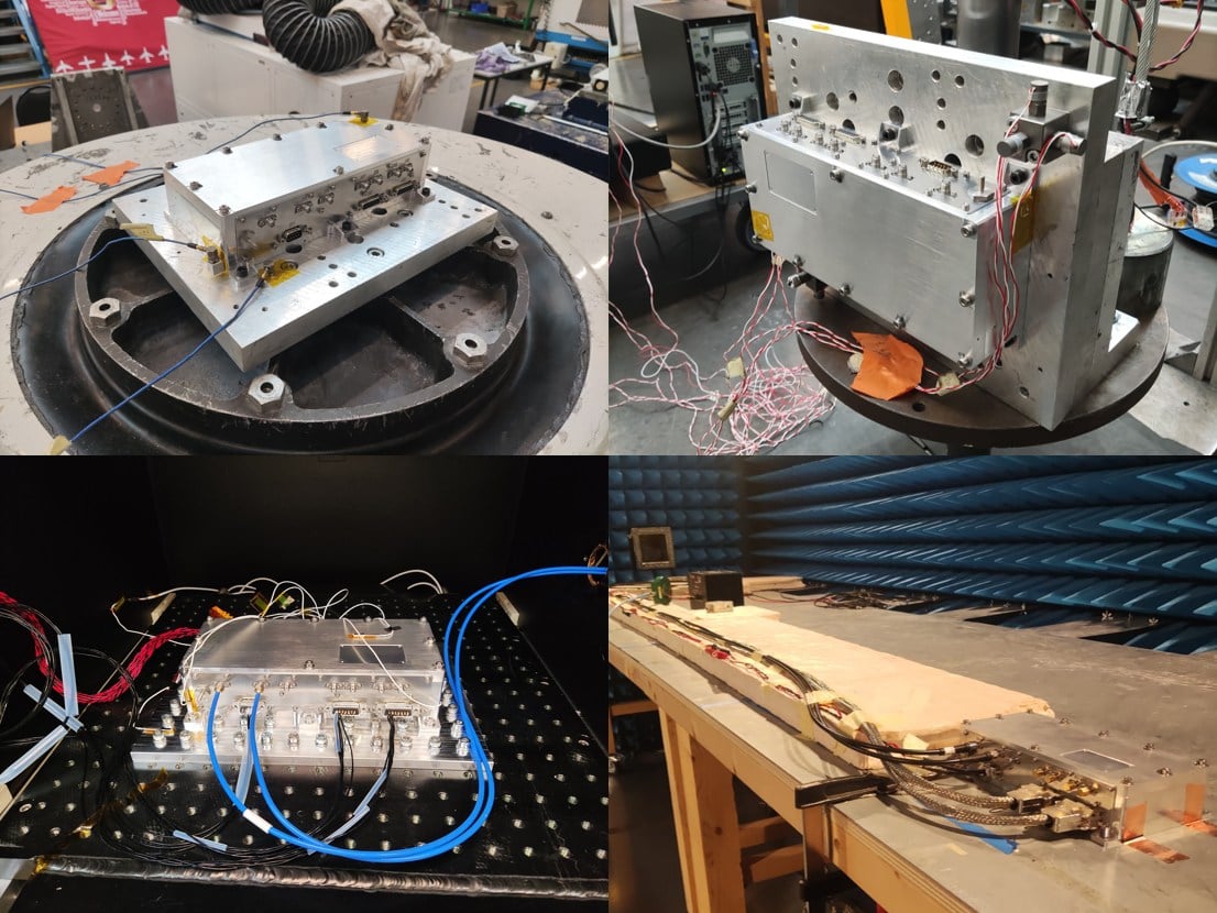
SpacePNT SA, a global provider of high-accuracy, radiation-tolerant spaceborne GNSS receiver equipment for missions ranging from Earth to cislunar orbit, has completed extensive qualification testing of its second-generation product, including vibration, shock, thermal vacuum and electromagnetic compatibility tests.
The multi-frequency, multi-GNSS receiver resulted from two European Space Agency (ESA) ARTES Competitive & Growth (C&G) development projects supported by ESA and the Swiss Space Office.
The first project enabled SpacePNT to develop an industrialized second-generation product for large-scale production targeting low-Earth orbit, LEO position-navigation-timing and geostationary orbit telecommunications constellations. The receiver includes a proprietary Precise Orbit Determination algorithm that provides sub-decimeter real-time positioning and timing aboard spacecraft. The company validated the POD algorithm in a hardware-in-the-loop environment and retrofitted it into two first-generation flight models delivered to a customer for satellite integration.
Under the second project, SpacePNT developed a Radiation Hardiness Assurance approach for long-duration missions in harsh radiation environments. ESA’s GENESIS satellite mission, which will operate in a challenging medium Earth orbit environment, will be the first to use this RHA approach. SpacePNT will supply the mission’s GNSS receiver equipment.
Though the second-generation receiver uses largely the same hardware, software and firmware technology as the company’s flight-proven first-generation product, SpacePNT performed a complete qualification campaign to validate design changes.
After passing all qualification and performance tests, SpacePNT will begin manufacturing first flight models of its second-generation products for several customers. The receivers will fly on demanding Earth observation, in-orbit servicing and space exploration missions at altitudes from LEO through medium Earth orbit, geosynchronous transfer orbit, geostationary orbit and lunar distances.
The views expressed herein do not reflect the official opinion of the European Space Agency.
Sateliot, a leading satellite telecommunications operator in 5G IoT connectivity, will test a pioneering system that allows its satellites to connect with IoT devices without relying on GNSS. The breakthrough opens new opportunities in sectors such as defense and security, where Europe’s technological autonomy and operation in GNSS-denied environments are strategic priorities.
Low-Earth orbit (LEO) satellite constellations, such as the one developed by Sateliot, provide coverage in areas beyond the reach of terrestrial networks — over half of the planet’s surface. However, until now, they depended on GNSS, increasing both the energy consumption of devices and terminal costs.
The FreeGNSSNetwork project, signed with the European Space Agency (ESA) and led jointly with GMV, eliminates this dependency using advanced algorithms that enable devices to calculate their position directly from the satellites’ signals. This maintains a stable and accurate connection even under complex conditions such as wartime scenarios.
According to the company, this project represents a paradigm shift and lays the groundwork for developing 6G technology, in which Sateliot actively contributes within the 3GPP framework.
The FreeGNSSNetwork enables device positioning with an accuracy of approximately 10 meters and provides extremely precise time synchronization services of 50 nanoseconds, the equivalent of 0.00000005 seconds.
The system is being tested in laboratories that replicate real satellite communication conditions and will be demonstrated in orbit with prototype satellites and terminals, sending positioning, navigation, and timing (PNT) data directly to IoT devices.
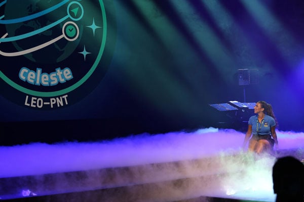
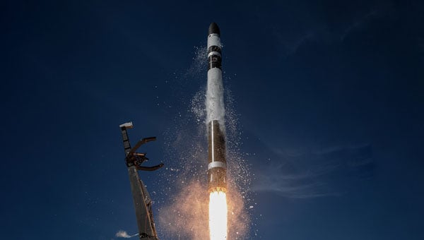
The European Space Agency (ESA) has confirmed plans to launch the first two satellites in its low-Earth orbit (LEO) positioning navigation and timing (PNT) constellation in the second half of December 2025. The launch will use a Rocket Lab Electron Vehicle, marking Europe’s first venture into LEO-based satellite navigation.
The LEO-PNT in-orbit demonstrator mission, called Celeste, aims to test satellite navigation capabilities in LEO and evaluate its integration with existing medium-Earth orbit (MEO) systems.
Celeste features a constellation of ten satellites that will fly close to Earth to test innovative signals across various frequency bands. The first two Celeste satellites, built in parallel by GMV and Thales Alenia Space, are set to launch in the coming months.
The dedicated Electron rocket launch will place both satellites in orbit at 510 km altitude. The launch window extends for three months beginning in mid-December 2025, with operations conducted from Rocket Lab’s New Zealand facility.
ESA Director of Navigation, Javier Benedicto, said, “We are thrilled to see the LEO-PNT demonstration advancing so quickly, with less than two years between mission kick-off and launch. This launch ensures the first European LEO-PNT satellites are in space before spring 2026, crucial for bringing the frequencies into use in compliance with the International Telecommunications Union.”
Galileo’s “Daughter Mission”
The name Celeste pays homage to Maria Celeste, Galileo Galilei’s daughter, as the two shared a strong emotional and intellectual bond, with the daughter honoring her father’s astronomical interest. This symbolic connection links the pioneering work of the father of modern astronomy to contemporary navigation systems, with Celeste serving as a bridge between Galileo’s groundbreaking discoveries and today’s satellite-based positioning technology.
The demonstrator satellites for Galileo, launched in 2005 and 2008, were called GIOVE, after the Italian word for Jupiter. This name also paid tribute to Galileo’s achievements in discovering the planet’s four largest Moons which were used to determine longitude from anywhere on Earth.
System Advantages
The initial Pathfinder A satellites are CubeSats measuring 12U and 16U formats, comparable to suitcase size and weighing approximately 20 kg to 30 kg. These satellites will broadcast in L-band and S-band frequencies and operate for at least six months following orbital commissioning.
The larger, more complex Pathfinder B satellites will follow, incorporating additional payloads to test innovative signals across multiple frequency bands and demonstrate expanded services.
LEO-PNT satellites will supplement existing GNSS constellations by providing enhanced coverage in challenging environments. The system aims to improve navigation services in deep urban areas, under heavy foliage, in polar regions and potentially indoor locations where current MEO satellites face limitations.
The complete demonstrator constellation, expected to be operational by 2027, will assess how LEO navigation systems can integrate with existing GNSS infrastructure. The mission will also test interoperability with 5G and 6G communication standards.
Preparing for Launch
Satellite integration and testing of Pathfinder A hardware and software continues ahead of the December launch. ESA and industrial teams plan to complete testing during summer 2025, with qualification and acceptance reviews scheduled for autumn.
“Pathfinder A satellites have already paid off, even before launch,” said Roberto Prieto-Cerdeira, ESA’S LEO-PNT project manager. “The experience gathered during their development is helping to identify critical technologies, system design trade-offs, design choices and optimised approaches and processes, paving the way for future phases of LEO-PNT. Having them in orbit and validating their signals and algorithms is a major additional achievement.”
Future Plans
Following the demonstrator mission, ESA plans to propose an in-orbit preparatory phase at the agency’s November Ministerial Council meeting. This phase would focus on technology development and industrialization, potentially leading to an operational system integrated with EU GNSS infrastructure.
The Celeste demonstrator is part of FutureNAV, an ESA Navigation program designed to maintain Europe’s position at the forefront of satellite navigation technology.
The mission receives backing from 15 ESA member states: Austria, Belgium, Finland, France, Germany, Hungary, Italy, Norway, Poland, Portugal, Romania, Spain, Sweden, Switzerland and the United Kingdom. More than 50 entities from 14 countries participate in the two development consortia awarded contracts in 2024.
The rapid growth of satellite constellations in low-Earth orbit (LEO), the risk of orbital collisions is rising at an unprecedented rate. The increasing amount of space debris — ranging from active satellites to defunct assets and debris — poses serious challenges for operators striving to maintain the safety and sustainability of their missions. As daily data volumes grow and conjunction warnings become more frequent, the space community faces pressure to adopt more advanced and reliable collision avoidance solutions.
In response to these growing challenges, the European Space Agency (ESA) has awarded GMV a research and development contract under the ARTES Core Competitiveness program, aimed at improving collision avoidance services for large telecommunications constellations. The initiative will focus on developing advanced capabilities for FOCUSOC NXTGEN, a platform designed to deliver faster and more accurate collision risk assessments by using diverse data sources and enhanced response strategies.
As part of the project, a conjunction assessment center will be established in the United Kingdom to expand support for satellite operators both domestically and internationally. The new system architecture aims to handle higher volumes of data and provide scalable performance to match the needs of next-generation constellations, potentially exceeding 1,000 satellites per constellation.
FOCUSOC NXTGEN incorporates several features, including a dedicated database for trend analysis, a maneuver testing environment grounded in flight dynamics, API integration for efficient operations, and a redundant infrastructure to ensure continuous service availability. The system seeks to filter out false positives from daily orbital data, identify genuine threats more accurately, and deliver timely recommendations to operators for effective maneuver planning.
The service is set for launch in summer 2026 in coordination with industry partners. ESA officials note that enhancing orbital collision avoidance technologies will be crucial to maintaining safe and sustainable operations as satellite numbers continue to rise.
ESA’s ARTES Core Competitiveness program provides funding and expertise to strengthen the satellite communications sector across Europe and Canada. The program supports both technology development and efforts to bring innovative products and services to market.
The European Space Agency (ESA) has selected Rocket Lab Corporation to launch a dedicated Electron mission, marking the first time the company will deploy satellites for ESA’s next-generation navigation constellation, low-Earth orbit positioning, navigation and timing (LEO-PNT). Thales Alenia Space and GMV, two European satellite prime contractors, are providing the “Pathfinder A” spacecraft for the mission. Rocket Lab plans to launch the satellites from Launch Complex 1 no earlier than December 2025.
The mission will place the two satellites in a 510 km LEO to test a new method of delivering location, direction and timing services from satellites in low orbit, known as LEO-PNT. ESA will use this demonstration to evaluate how a low Earth orbit satellite fleet can work with the Galileo and EGNOS constellations, which provide Europe’s global navigation system from higher orbits.
This contract highlights Rocket Lab’s growing role as a launch provider for European constellation operators and demonstrates the Electron rocket’s strong reputation. Earlier this year, Rocket Lab deployed a full constellation of IoT satellites for French operator Kinéis and launched a global wildfire detection mission for Germany-based OroraTech. Since 2021, Rocket Lab has supported European satellite operators with Electron missions
Agilica BV has completed a feasibility study to develop a complementary PNT (positioning, navigation, timing) system that would enable precision drone navigation and landing in environments where GNSS signals are degraded or unavailable.
Funded by the European Space Agency, the study validates the technical and commercial viability of the AGL system. The system integrates GNSS receivers into the infrastructure for seamless transition to and from GNSS in high-impact applications, including drone landings on moving vessels, operations in indoor facilities, and autonomous deliveries in complex urban or offshore environments.
“Landing a drone on a moving ship in dynamic conditions is one of the toughest challenges in drone autonomy,” said Bart Scheers, Agilica’s COO. “Our AGL system is built to solve this — not by replacing GNSS, but by augmenting it. This feasibility study confirms that our patented UWB approach can extend PNT services, with sub-20 cm precision in GNSS-denied zones.”
The AGL system is based on time-of-flight ultra-wideband technology and functions like a dedicated terrestrial GNSS network to deliver centimeter-level accuracy and resilience in GNSS-compromised environments where vision-based systems and QR codes fall short, according to the company.
The study represents a critical step on the commercialization roadmap of Agilica’s core product — the AGL system — by adding built-in compatibility with GNSS and Galileo High Accuracy Service to its ultra-wideband positioning solution for drones in the maritime, logistics, and urban air mobility sectors.
SFL Missions joins a team led by NUVIEW GmbH, which the European Space Agency has contracted to conduct a Pre-Phase A study for the Moonraker lunar mapping mission. This study launches under a new initiative for Small Exploration Missions. The Moonraker satellite will carry a laser scanner to create a detailed elevation map of the Moon’s surface.
The Moonraker mission will deploy a single orbiter in a low-altitude polar orbit around the Moon. The orbiter will host a lidar payload to capture highly accurate elevation points of the terrain. The team will use these data points to generate three-dimensional elevation models, which will guide the assessment and selection of future lunar landing sites.
Moonraker’s lidar data also seeks to advance broader scientific research. The mission will scan permanently shadowed regions to search for water ice and provide new insights into the Moon’s geology and internal composition. The Moonaker lidar will operate in two modes: one for broad-area scanning of the lunar polar regions and another for high-resolution surveys of specific areas of interest.
SFL Missions shared in a statement that Mission analysts are evaluating potential launch options and trajectories to efficiently enter lunar orbit. They are also studying how operational orbit parameters affect spacecraft design and payload data collection. The system design team focuses on accommodating the payload, configuring the spacecraft layout, and sizing subsystem components. They are designing the propulsion system to carry enough fuel for the transit phase and to maintain the operational orbit, compensating for disturbances from the Moon’s irregular gravity field. The team is developing detailed mission and system requirements to guide future design phases.
NUVIEW GmbH, based in Berlin, leads the Pre-Phase A study team, which includes several partners alongside SFL Missions. NUVIEW GmbH, a wholly owned subsidiary of NUVIEW Inc., is developing the world’s first commercial space-based LiDAR constellation for three-dimensional mapping of Earth.
SpacePNT has joined the European Space Agency’s Genesis mission, a navigation satellite project that will be the first to carry all four space-based geodetic techniques on board: GNSS, Satellite Laser Ranging (SLR), Very Large Baseline Interferometry (VLBI) and Doppler Orbitography and Radio-positioning Integrated by Satellite (DORIS).
SpacePNT’s NaviLEO spaceborne GNSS receiver technology was selected for the mission’s critical satellite navigation ranging instrument. Although NaviLEO has flight heritage in low-Earth orbit, it will be adapted for Genesis to operate in medium-Earth orbit at 6,000 km. The system will use a dual-antenna configuration to receive GNSS satellite signals from both zenith- and nadir-looking antennas.
The Genesis mission aims to update the International Terrestrial Reference Frame (ITRF), a global Earth model, targeting an accuracy of 1 mm and long-term stability of 0.1 mm per year. This will provide a precise coordinate system for advanced navigation applications.