Tag: Maxar

  • Maxar Intelligence rebrands to Vantor, unveils AI-powered platform

    Maxar Intelligence rebrands to Vantor, unveils AI-powered platform

    Vantor has rebranded from Maxar Intelligence. The newly named company also unveiled Tensorglobe, an AI-powered spatial intelligence platform.

    The rebrand represents the culmination of the company’s multi-year journey to productize its core operational technology and transform from a satellite imagery provider into an end-to-end spatial intelligence company.

    According to the company, the name Vantor speaks to how the company unlocks a real-time competitive advantage by delivering total clarity for missions across the space, air and ground domains, ending the era of disconnected sensor platforms. “Vantor is solving the most critical challenges across the defense and commercial sectors, including the urgent need for more advanced battlespace systems and the push to unleash autonomy across every industry,” the company said in a press release.

    The company addresses these challenges with multi-domain spatial intelligence solutions that integrate sensor data across satellites, drones and ground-based assets to improve decision-making and drive autonomous operations at scale. Over the past six months, Vantor has launched several AI-enabled solutions, including:

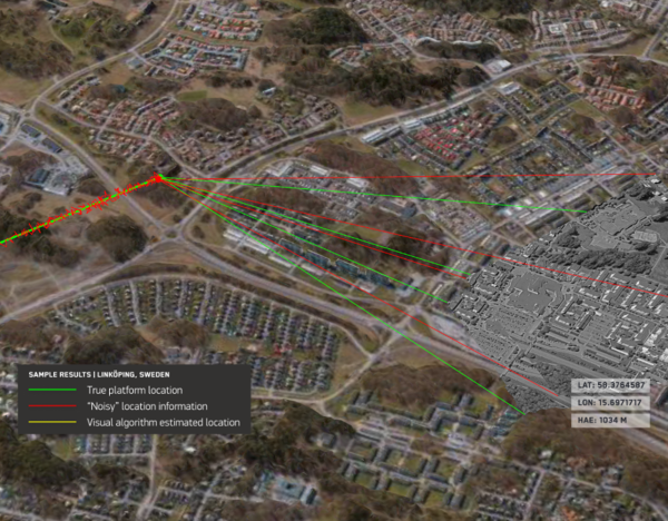
    • Raptor: A software suite that integrates Vantor’s 3D terrain data with a drone’s native camera to ensure that autonomous platforms can navigate effectively and extract target ground coordinates accurately in the absence of GPS.
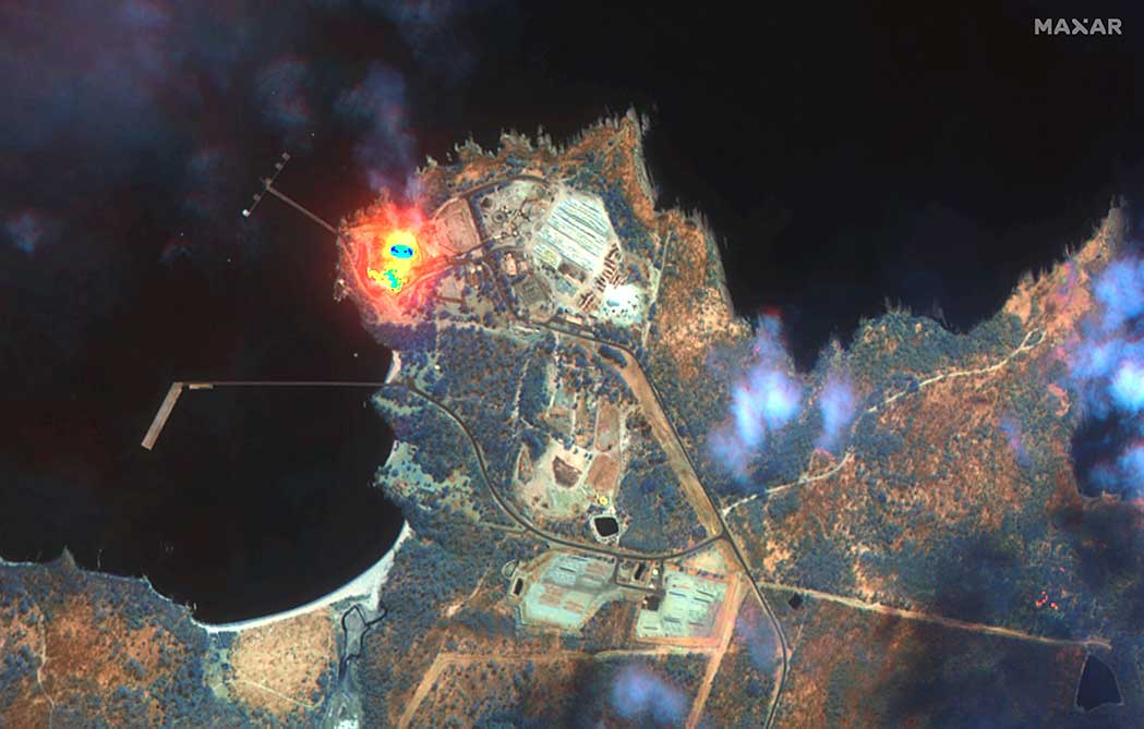
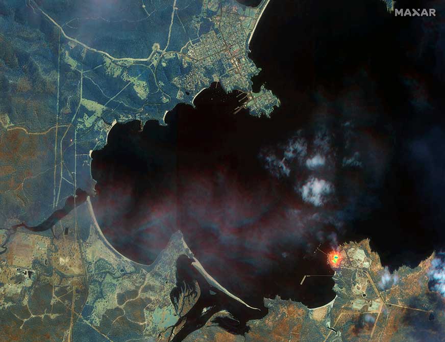
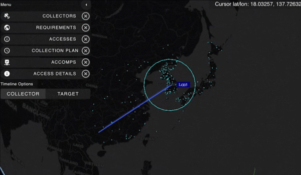
    • Sentry: A global-scale persistent site monitoring solution that can identify operational threats across hundreds of areas at once by integrating automated collection planning across multiple satellite constellations, including sovereign assets, with AI-driven data fusion and analytics.
    • Tensorglobe: An end-to-end platform that empowers organizations to build their own spatial intelligence system. Tensorglobe fuses sensor data from space, air and ground to create a living 3D globe, automating the intelligence cycle to keep this unified foundation up to date.

    Vantor has partnered with innovators across the defense and commercial sectors to jointly build integrated intelligence solutions. For instance, Vantor is delivering the foundational spatial intelligence for Anduril’s next-generation mixed reality combat system designed for the U.S. Army’s Soldier Borne Mission Command Architecture (SBMC-A) program. The company has also signed partnerships with Saab and Taiwan’s AIDC to integrate Raptor into mission-ready systems designed for contested environments.

  • Maxar helps accelerate the resilience of Taiwan’s UAV industry against GPS interference

    Maxar helps accelerate the resilience of Taiwan’s UAV industry against GPS interference

    Maxar Intelligence is partnering with Taiwan’s Aerospace Industrial Development Corporation (AIDC) to deploy the Maxar Raptor software suite across Taiwan’s unmanned aerial vehicle (UAV) industry. The move will help the country accelerate the resilience and reliability of autonomous systems in GPS- and GNSS-denied environments.

    Raptor is a vision-based software suite that enables autonomous drones to navigate precisely and extract accurate ground coordinates in the absence of GPS. Designed for lightweight integration with any autonomous platform, Raptor products use a drone’s native camera and Maxar’s 100 million-plus sq km of global 3D terrain data to help the platform navigate with extreme precision and extract accurate ground coordinates in real-time without GPS. Raptor can operate at night and in low-altitude flight operations without the need for any additional hardware.

    The partnership follows a successful field demonstration of Raptor software in Taiwan earlier this year, in which the test platform was able to maintain precise navigation under GPS-denied conditions using only its native camera and Maxar’s software.

    The test platform was able to maintain precise navigation under GPS-denied conditions using only its native camera and Maxar’s software.

    “Taiwan is rapidly building one of the most advanced UAV industries in the world, and AIDC is one of the companies leading the charge,” said Anders Linder, general manager, International Government at Maxar Intelligence. “Taiwanese UAV manufacturers are acutely aware of the importance of building resilience against GPS jamming, and AIDC has validated the unique capabilities of our Raptor software. By combining our geospatial intelligence with AIDC’s aerospace expertise, we’ll help Taiwan’s UAV industry maintain its forward momentum, accelerating autonomy across warfighting, humanitarian, and commercial operations.”

    AIDC will drive the adoption of Raptor across Taiwan’s UAV supply chain and promote use of the software across the Taiwan Excellence Drone International Business Opportunity Alliance (TEDIBOA), an organization that AIDC chairs.

    “This collaboration opens a new chapter for precision vision-based positioning in Taiwan’s UAV sector,” said AIDC President Chin-Ping Tsao. “We will jointly build a Taiwan-focused integration and testing center, highlight GPS-jamming resilience as a core differentiator, and unlock opportunities across Taiwan and the broader Asia market — advancing both defense resilience and commercial value.”

  • Seen & Heard: UAVs to the rescue, fire strikes in Chile

    Seen & Heard: UAVs to the rescue, fire strikes in Chile

    “Seen & Heard” is a monthly feature of GPS World magazine, traveling the world to capture interesting and unusual news stories involving the GNSS/PNT industry.


    Photo: ChristinaFelsing / iStock / Getty Images Plus / Getty Images
    Photo: ChristinaFelsing / iStock / Getty Images Plus / Getty Images

    UAVs to the rescue

    A child reported missing in Robbinsville, N.J., was found in less than 10 minutes using a UAV equipped with a thermal camera, WPVI reported.

    On the night of January 17, Robbinsville Police received a call reporting a missing child last seen running into a heavily wooded area. Officers dispatched the department’s UAV equipped with thermal imaging cameras, which allowed officers to quickly locate the missing boy through thick vegetation after dark. The child was unharmed, according to the report.


    Photo: Maxar Technologies
    Photo: Maxar Technologies

    Fire strikes Chile

    Maxar Technologies has released satellite images showing the widespread damage caused by raging wildfires in Chile’s Valparaíso region. The fires have killed more than 122 people. The images show entire neighborhoods destroyed east of the resort town of Viña del Mar yet do not show active wildfires. The fires reportedly surged in the Valparaíso region, fueled by winds and an intense heatwave that has seen temperatures of around 40° C.


    Photo: seregalsv / iStock / Getty Images Plus / Getty Images
    Photo: seregalsv / iStock / Getty Images Plus / Getty Images

    No drones in the prison yard

    The UK government has introduced regulations establishing a 400 m UAV “no-fly zone” around prison facilities. The announcement addresses the escalating use of UAVs by criminals attempting to transport illicit items — including phones, drugs and weapons — into prisons.

    The initiative is a response to the increase in the number of UAVs detected or sighted within prison grounds, which more than doubled between 2019 and 2021, according to a press statement from the UK government. The implementation of “no-fly zones” aims to enhance law enforcement’s ability to catch organized criminals in the act. Additionally, these measures are designed to prevent illegal aerial filming of prisons.


    Photo: Bim / E+ / Getty Images
    Photo: Bim / E+ / Getty Images

    Back to the fields

    GNSS jamming by the Israeli Defense Forces (IDF) has forced retired farmers in the Israeli settlement Mevo Hama to return to the fields. In an interview with CTech, local farmer Rami Laner shared that the younger equipment operators do not know how to operate the modern tractors for spraying or sowing tasks without the aid of their GNSS-based autonomous systems. With the IDF intentionally jamming and spoofing GNSS signals, civilians in the area are in search of alternative PNT systems to protect communities and maintain workflows.

  • Massive earthquake shifts land in Japan

    Massive earthquake shifts land in Japan

    Image: Maxar Technologies
    Image: Maxar Technologies

    A series of powerful earthquakes hit western Japan on Jan. 1, killing at least 55 people and damaging thousands of buildings, vehicles and boats, reported CNN. Japanese officials warn that more earthquakes could lie ahead.

    Aftershocks continued to shake Ishikawa Prefecture and nearby areas after the initial magnitude 7.6 earthquake struck the area.

    According to Japan’s Geospatial Information Authority (GSI), the earthquake may have shifted land in the Noto region near the peninsula, where the ocean floor shifted and generated tsunami waves of about 80cm in height. GSI said preliminary figures indicate that an observation point in Wajima City in Ishikawa Prefecture saw the biggest shift, which moved about 1.3 meters west.

    Land appears to have shifted about 20 centimeters to the northwest in the prefectures of Toyama and Niigata. Several centimeters of land shifts were observed in the Kanto-Koshin region and elsewhere.

    Scientists have also been watching Japan from space, comparing satellite images taken before and after the earthquake.

    On its latest pass, the ALOS-2 spacecraft reported the distance between itself and the ground had shortened as the Earth’s surface had risen up under the force of the tremor.

    Fortunately, the uplift may have lessened the impact of the waves when they arrived at the shoreline, said GSI.

    GSI plans to continue analyzing the data for other movements.

  • Russia could target GPS, warns NRO director

    Russia could target GPS, warns NRO director

    NRO Director Christopher Scolese
    NRO Director Christopher Scolese

    Russia’s military could target GPS and communication satellites as part of its war in Ukraine, reports Space News.

    The news outlet cites U.S. National Reconnaissance Office (NRO) Director Christopher Scolese speaking Feb. 23 at the National Security Space Association’s Defense and Intelligence Space Conference.

    “I think we’re seeing pretty clearly that Russia is committed to doing what they want to do in Ukraine, and they want to win,” Scolese said. “So I think it’s fair to assume that, to the extent that they can, and to the extent that they feel it won’t extend the conflict out of their control, that they will extend it into space.” 

    An attempt to disrupt the United States’ space ability could affect satellites of private operators as well, such as Maxar, which is distributing imagery of the conflict.

    The U.S. Air Force’s Lockheed Martin-built next generation GPS III satellite on orbit. Rendering portrays GPS III Space Vehicles (SVs) 01-10. (Artist's Rendering: Lockheed Martin)
    A next-generation GPS III satellite on orbit. (Artist’s Rendering: Lockheed Martin)

  • Maxar 3D data integrated into Swedish fighter jet for GPS-denied navigation

    Maxar 3D data integrated into Swedish fighter jet for GPS-denied navigation

    Saab, the Swedish defense and security company, and Maxar recently demonstrated a solution to GNSS-denied navigation by integrating Maxar’s 3D Data and Precision 3D Registration (P3DR) technology into the fighter jet software for the Swedish Gripen E fighter jet.

    Saab develops and manufactures the fighter jet for Sweden and other countries.

    A camera on the jet captures a livestream of its flight path. Maxar’s P3DR compares that incoming livestream to the Maxar 3D Surface Model of the area stored on the jet. By matching scenes in the livestream to the 3D data in real time, P3DR can determine the jet’s precise location, enabling the pilot to navigate and carry out the mission without GPS.

    Maxar 3D Surface Model, immersive 3D data with superior accuracy and global coverage, offers a highly accurate representation of Earth. The data is produced with unique automated technology, delivered rapidly and with high precision. It is based on Maxar’s high-resolution, unclassified commercial satellite imagery, without the need for ground control points. Maxar’s 3D Surface Model product is a key input to the company’s Globe in 3D, a worldwide foundation of 3D data with resolution of 50 cm or better and 3 m accuracy in all dimensions.


    The chart across the top of the video indicates the accuracy of the P3DR matching of the livestream video to the Maxar 3D Surface Model. When the camera encounters clouds, it lowers the accuracy of P3DR’s match; however, as long as there is some view of the ground, the accuracy is relatively high.

    Maxar’s P3DR is a standalone software solution that automatically geo-registers imagery from any source to Maxar 3D reference data. This real-time capability enables navigation in a GPS-denied environment, safeguarding against signal jammers in an anti-access area denial (A2AD) environment.

    Saab put the GPS-denied navigation technique to the test with a Gripen flight demonstration over Sweden. The GIF below demonstrates how P3DR closely overlays the livestream image on the Maxar 3D Surface Model, allowing the pilot to understand where they are on the map.

    During the flight demonstration, the Gripen’s GPS receiver was on to monitor the accuracy of the results. The GPS receiver verified that the demonstration’s results were accurate.

    The Gripen E jet fighter built by Saab. (Photo: Saab)
    The Gripen E jet fighter built by Saab. (Photo: Saab)

  • Visualizing the Australian bushfires through satellites and maps

    Visualizing the Australian bushfires through satellites and maps

    The months-long wildfires raging in Australia have killed at least 25 people. Millions — possibly 1 billion — animals have died. More than 2,000 houses have been destroyed. Around 150 fires are still burning in New South Wales and Queensland, with hot and dry conditions accompanied by strong winds fueling to the fires’ spread.

    With this conflagration rocking the continent down under, satellite imagery has become important to understanding the scope of the disaster. Here are some of the recent captures.

    As seen from the ISS

    “Talking to my crew mates, we realized that none of us had ever seen fires at such terrifying scale,” European Space Agency astronaut Luca Parmitano tweeted on Monday, sharing photos taken from the International Space Station.

    The astronaut posted images showing what he described as “an immense ash cloud” captured at the time the ISS was flying toward sunset.

    Artist’s visualization misinterpreted

    Another social media image, shared widely, was interpreted as a map showing the live extent of fire spread, with large sections of the populous eastern coastline molten red. Because of widespread misinterpretation, the original poster then explained that the image was a 3D visualization and not a photograph of Australia, and showed some areas where fires have been extinguished.


    View this post on Instagram


    * Didn’t realise this would go viral ? PLEASE READ BELOW* Regarding False Information. This has occurred NOT because of this post, or my information being inaccurate. It has been Zucc’d because other people have shared this image with the caption “This is a NASA photograph”. This image has been flagged as a result. Update – this is now being corrected, finally. Should be clear in a day or so… This is a 3D visualisation of the hotspots in Australia. NOT A PHOTO. Think of this as a graph. Also note this was created as an art piece This is made from data from NASA’s FIRMS (Satellite data regarding fires) between 05/12/19 – 05/01/20. These are all the areas which have been affected by bushfires. https://firms.modaps.eosdis.nasa.gov/map/#z:5;c:137.4,-27.9;t:adv-points;d:2019-12-05..2020-01-05;l:dark_gray,firms_viirs,firms_modis_a,firms_modis_t Scale is a little exaggerated due to the render’s glow, but generally true to the info from the NASA website. Also note that NOT all the areas are still burning, and this is a compilation. This image is copyrighted by Anthony Hearsey. Please contact for usage. DONATE HERE – https://linktr.ee/lukebakhuizen?fbclid=IwAR1hxUc97BXMPIxjiJqcVW7uG8wlgkPLfyO2wVFLVRDSw5X6cXAGeBuikeM _ #bushfires #render #visualisation #data #3d #australia #climatechange #disaster #fire #infographic #cinema4d #graphic #nasa

    A post shared by Anthony Hearsey (@anthony_hearsey) on


    NASA and USGS Landsat images

    NASA and the U.S. Geological Survey’s Landsat 8 satellite imagery from Jan. 9 shows Kangaroo Island, home to nature reserves. The images were taken using the Operational Land Imager (OLI) on Landsat 8. Using natural-color observations, the images show burned land and thick smoke covering the island, of which at least 156,000 hectares have burned.

    Photo: NASA/USGS
    Photo: NASA/USGS

    The U.S. National Oceanic and Atmospheric Administration (NOAA) satellites are also capturing images, including the resulting plumes of smoke.

    Worldview-3 captures Australia’s wildfires

    Maxar collected satellite imagery Jan. 12 of the wildfires in New South Wales (NSW). The imagery shown below focuses on the area near the town of Eden, and demonstrates the value of the shortwave infrared (SWIR) sensor.

    SWR satellite imagery of the town of Eden shows the wildfires through the smoke. (Satellite images ©2020 Maxar Technologies)
    SWR satellite imagery of the town of Eden shows the wildfires through the smoke. (Satellite images ©2020 Maxar Technologies)

    In an image taken with Maxar’s normal RGB color imagery, the smoky air prevents a clear view of the fires and the hot spots. With Maxar’s WorldView-3 satellite, however, the team is able to penetrate through the smoke using its SWIR sensor for a detailed look at the fire lines and burned vegetation.

    With SWIR imagery, burning areas are apparent and show up in a glowing orange-red. Healthy vegetation shows up in shades of blue, and burned vegetation appears in shades of brown.

    Satellite Photo: :ESA
    Satellite Photo: :ESA

    Copernicus Sentinel-3 imagery

    Europe’s Copernicus Sentinel-3 mission has captured the multiple bushfires burning across Australia’s east coast.

    In the above image, captured on Nov. 12, 2019, at 23:15 UTC (Nov. 13, 09:15 local time), the fires burning near the coast are visible. Plumes of smoke can be seen drifting east over the Tasman Sea. Hazardous air quality owing to the smoke haze has reached the cities of Sydney and Brisbane.

    Flame retardant was dropped in some of Sydney’s suburbs as bushfires approached the city center, and many residents were evacuated. Firefighters continue to keep the blazes under control.

    The Copernicus Emergency Management Service – Mapping was activated to help respond to the fires. The service uses satellite observations to help civil protection authorities and, in cases of disaster, the international humanitarian community, respond to emergencies.

    Quantifying and monitoring fires is fundamental for the ongoing study of climate, as they have a significant impact on global atmospheric emissions. Data from the Copernicus Sentinel-3 World Fire Atlas shows that there were almost five times as many wildfires in August 2019 compared to August 2018.

    Additional images from Worldview-3

    Fireline south of Eden. (Satellite image ©2020 Maxar Technologies)
    Fireline south of Eden. (Satellite image ©2020 Maxar Technologies)

    Fires new Eden. ( Satellite image ©2020 Maxar Technologies)
    Fires new Eden. (Satellite image ©2020 Maxar Technologies)

    Closeup of fires at Honeysuckle Point south of Eden. (9atellite image ©2020 Maxar Technologies)
    Closeup of fires at Honeysuckle Point south of Eden. (9atellite image ©2020 Maxar Technologies)