Max Weber famously described how bureaucratic inertia often leads formal organizations, such as government agencies, to devise new justifications for themselves after they have outlived their original purpose. That is certainly not the case for the U.S. Space Force, which is in its infancy and is responsible for key missions, including operating the Global Positioning System that it took over from the United States Air Force about two years ago.
However, bureaucratic inertia can also refer to the tendency of organizations to continue to pursue projects or approaches that may no longer be the best match for their goals, missions, or budgets. A recent, congressionally-mandated report by the United States Government Accountability Office (GAO) — Report to Congressional Committees, GPS MODERNIZATION: Space Force Should Reassess Requirements for Satellites and Handheld Devices, issued in June — questions the Space Force’s approach to modernizing GPS with a more jam-resistant, military-specific signal known as M-code.
In 2005, the Air Force launched the first GPS satellite capable of broadcasting the M-code signal, which is at the core of a multi-billion-dollar modernization and sustainment effort. Yet, 18 years later, widespread adoption of the technology is still hampered by delays in upgrading GPS ground and user equipment. Approximately 700 types of weapon systems — including ground vehicles, ships and aircraft — will ultimately require M-code-capable user equipment.
Providing M-code requires the cooperation of GPS’ ground, space and user equipment segments. Regarding the first one, the report states: “In 2022, Space Force further delayed delivery of the ground control segment due to development challenges. This delay pushes delivery until December 2023 at a minimum. Space Force officials have not finalized a new schedule and acknowledged that remaining risks could lead to additional delays.”
Regarding the space segment, it states: “Space Force met its approved requirement for 24 M-code-capable satellites on orbit but determined that it needs at least three more to meet certain user requirements for accuracy. Building and maintaining this larger constellation presents a challenge. GAO’s analysis indicates it is not likely that 27 satellites will be available on a consistent basis over the next decade.”
Finally, regarding the user segment, it notes that development of the Military GPS User Equipment (MGUE) Increment 1 has progressed “to the point where the military departments are ready to commence activities in support of testing and fielding it on the lead weapon systems.” However, it cautions that “[d]elays and unexpected challenges could affect the fielding of capability for some systems.”
GAO’s report recommends that the United States Department of Defense (DOD) assess the number of GPS satellites necessary to meet operational needs, and either develop a sound business case for the M-code-capable Increment 2 handheld, or not initiate the effort. The DOD concurred with both recommendations.
“Who Runs GPS?”, the special feature in our February 2023 issue, which detailed the structure of this vast enterprise, listed an executive committee, a coordination office, an oversight council, two Space Force commands, and, as partners, several federal departments and agencies. Has this complex structure become too diffuse to make tough decisions?
GPS is the gold standard for precise positioning, navigation, and timing (PNT), impacting the lives of more than six billion users worldwide. The United States economy alone depends on the free, government-provided service across 900 million GPS receivers supporting vehicle navigation systems, general aviation, financial transactions, the electrical grid, precision agriculture, surveying and construction. The GPS enterprise must remain consistent and reliable, while keeping pace with emerging technology without interruption for the end user.
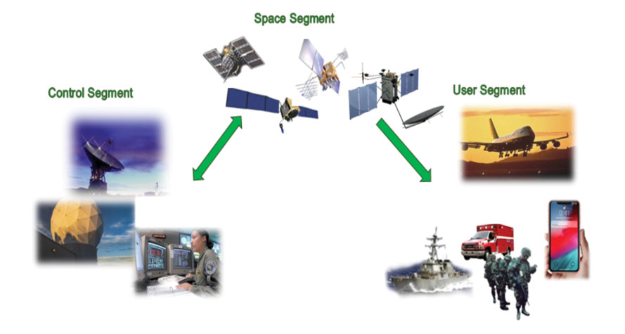
Space Systems Command (SSC) at Los Angeles Air Force Base in El Segundo, California — the U.S. Space Force’s space development, acquisition, launch and logistics field command — is responsible for maintaining and modernizing the GPS enterprise. The enterprise consists of three segments: the space segment, the control segment and the user segment. Each achieved specific milestones during an exciting and productive 2022.
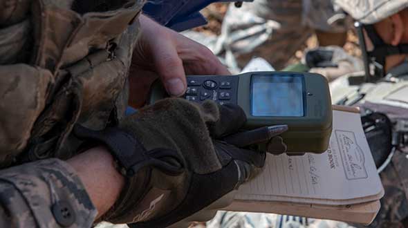
A new MGue for warfighters is moving closer to completion. (Image: EvgeniyShkolenko/iStock /Getty Images Plus/Getty Images)
Space Segment
There are currently 37 GPS satellites on-orbit with 31 set healthy. The constellation requires 24 operational satellites for worldwide coverage and a receiver needs to receive transmissions from four of them to determine its position in three dimensions. GPS continues to operate impressively with an average 45-cm accuracy throughout the past year with the most precise day on record at 31.5 cm. The space segment of GPS modernization focuses on GPS III and GPS IIIF satellite development with significant milestones rounded out in 2022.
For GPS III, after the successful launch of Space Vehicle 5 (SV05) on June 17, 2021, it was set healthy (usable) on May 25, 2022. The significance of SV05 is its full operational capability of the improved civilian L2 (L2C) signal. L2C improves service speed for commercial users via access to two frequencies, improves accuracy when combined with legacy civil GPS signals (L1 C/A), and is less susceptible to ionospheric interference. SV05 is the 24th satellite enabled with the Military Code (M-code), providing worldwide M-code coverage. M-code is designed to give military receivers better defense against jamming, improved accuracy, a more secure and flexible cryptography architecture, and the ability to detect and reject false signals.
On Jan. 18, 2023, SV06 successfully launched into orbit aboard a SpaceX Falcon 9 Block 5 rocket from Cape Canaveral Space Force Station, Florida. The launch of SV06 marks a key step in the larger goal of modernizing the GPS constellation. Additionally, the 10th and final satellite in the GPS III fleet finalized production and has a target launch date of 2026. GPS III Space Vehicles 7–10 are in storage and available for launch.
The next generation of GPS satellites continues development. The October 2022 contract award for GPS III Follow-On (GPS IIIF) satellites will onboard additional capabilities. In addition to introducing new civil signals designed to enhance search-and-rescue efficacy and aviation safety, laser retroreflector array for precise ranging, and a fully digital navigation payload, the GPS IIIF satellites will offer a new Regional Military Protection (RMP) capability providing up to 60 times greater anti-jamming measures. A new port on the Lockheed Martin LM2100 Combat Bus supports a substantial increase in flexibility, providing rapid integration of payloads in response to emerging threats in space.
GPS Enterprise interrelated segments. (Image: Space System Command)
Control Segment
The Next Generation Operational Control System (OCX) will replace the current GPS Operational Control System (OCS), supporting the latest U.S. Department of Defense standards and practices for cybersecurity. The updated system includes a modernized and expanded monitor station network, improved anti-jam capabilities, and enhanced operational capability to control modernized military signals.
In March 2022, OCX completed its fourth and final legacy ground antenna element (LGAE) installation on Kwajalein Island in the Republic of the Marshall Islands. OCX Block 1 and 2 are undergoing Hewlett Packard (HP) Formal Qualification Test (FQT). This event will qualify much of the system’s previously certified mission software functions. The event will also demonstrate system maturity and readiness for system acceptance, operator training, and specific developmental testing milestones with both GPS space and user segments.
The next-generation control system, OCX 3F, will modify OCX Blocks 1 and 2 to use the enhanced capabilities of GPS IIIF satellites. OCX 3F received Milestone B and Acquisition Program Baseline (APB) approval from the Milestone Decision Authority (MDA) and was authorized to enter the Engineering and Manufacturing Development (EMD) phase in May. In November, the OCX 3F program deployed 3F mission software into OCX’s Near Operations Environment (NOE) for the first time after completion of the program’s first Integration Readiness Review (IRR). The IRR event ensures that the software meets integrity standards and receives approval to be integrated and tested on the NOE prior to software releases to the operational users. OCX 3F anticipates achieving operational acceptance in 2027.
The GPS III government and industry team recently core mated GPS III SV10 and nicknamed it “Hedy Lamarr” after the actress and inventor. (Image: Lockheed Matin)
User Equipment Segment
Among the arsenal of GPS user equipment, very few pieces have the technology to use the M-code signal. Maintaining a competitive advantage against the adversary requires use of these signals; the GPS Enterprise is focused on developing Modernized GPS User Equipment (MGUE) capable of accessing these signals. The MGUE program is a joint service program developing modernized M-code-capable military GPS receivers. The program is broken into two increments (Inc 1 and Inc 2). Both are designed to deliver secure PNT performance, allow navigation warfare operations, enhance anti-jam, enhance anti-spoof and anti-tamper, and enable Blue Force Electronic Attack.
As part of the multiple elements under the MGUE Inc 1 umbrella, L3Harris delivered its final Build 7 ground card to the government on Nov. 16, 2021, and completed regression testing on that kit in February 2022. The final Delta Security Certification and Approval were completed on April 13 and April 29, 2022, respectively. Development of the L3H Ground-Based GPS Receiver Applications Module (GB-GRAM-M) card, which delivers geolocation and precise positioning capabilities for space-constrained applications while providing increased security and anti-jam capabilities, is complete and available for services procurement. MGUE Inc 1 completed qualification testing for the aviation and maritime cards on Sept. 9, 2022, with updated software builds. This build allows the program to progress to 98% of the requirements verified and enables B-2 Bombers and Guided Missile Destroyers (DDG) to continue progress toward operational testing. Completion of this commitment means significant progress toward operational testing for stakeholders and warfighters.
MGUE Inc 2 held Preliminary Design Reviews for the Miniature Serial Interface (MSI) in summer 2022, bringing the project another step closer to finalizing the EMD phase. Once all closure and action items are completed for the reviews, the government will consider each event complete. Critical Design Review (CDR) is scheduled for this summer and will validate the system design and the ability to meet system performance requirements. MGUE Inc 2 continues to execute the second competitive objective under Phase I for the Joint Modernized Handheld component; the effort is moving closer to completion of the handheld prototype and will ultimately make for a more seamless transition to operations.
GPS ground antenna at Schriever Space Force Base in Colorado. (Image: U.S. Air Force)
Conclusion
The SSC’s mandate is paramount to maintaining our modern way of life. The space professionals dedicated to developing GPS technology are committed to delivering advanced capabilities to the warfighter, the civil sector, and the world. An interconnected world is ready for us. We’re on our way.
SSC is the U.S. Space Force field command responsible for acquiring and delivering the capabilities needed by warfighters to protect our nation’s strategic advantage in and from space. It manages an $11B budget for the U.S. Department of Defense and works in partnership with joint forces, industry, government agencies, academic and allied organizations to outpace emerging threats.
For analogous updates on the other three GNSS constellations, please see:
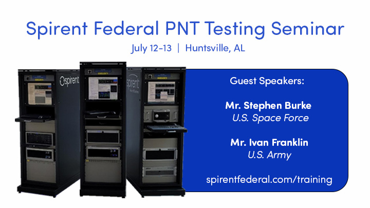
Guests include Stephen Burke from Space Systems Command and Ivan Franklin from the Assured Positioning, Navigation and Timing/Space (APNT/Space) Cross-Functional Team (CFT).
The seminar will take place in person in Huntsville, Alabama, July 12-13, and will provide extensive training on PNT applications using Spirent’s simulation solutions.
Burke will provide an update on Military GPS User Equipment (MGUE) for Increment 1 and Increment 2, as well as a briefing on the Space Systems Command PNT restructure. Burke is deputy to the Senior Materiel Leader, GPS User Equipment Acquisition Delta, for the Military Communication and PNT Directorate within U.S. Space Force Space Systems Command.
Franklin, Deputy APNT Signature Effort for the U.S. Army APNT/Space CFT, will share the latest on U.S. Army APNT, which is influencing the way soldiers operate in degraded and denied environments.
“Providing hands-on training for customers, or prospective customers, and discussing nascent PNT advancements at our annual training seminar is the highlight of our year,” said Roger Hart, director of engineering for Spirent Federal. “We work closely with the U.S. government and military and are pleased Stephen and Ivan have accepted our invitations to share their vital information and expertise with the attendees.”
Other seminar topics include
advanced jamming and in-the-field spoofing mitigation
encrypted GPS M-code and Y-code
complementary PNT, including inertial navigation systems
controlled reception pattern antennas (CRPA)
a patented approach to testing in anechoic chambers.
BAE Systems has produced more than one and a half million military GPS receivers. The company is transitioning receiver designs to use the modernized military code (M-code) signal for added resiliency in RF-challenged environments. We asked Luke Bishop, director and product line engineering lead for the company’s Navigation & Sensor Systems, a few questions.
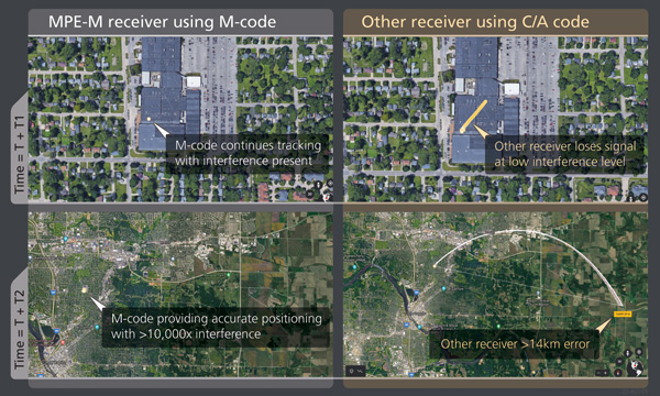
BAE Systems’ MPE-M provides the benefit of M-Code operation in a challenged RF environment. Image: BAE Systems
Why transition to M-code?
There are three key reasons for users to transition to M-code as supported by Military GPS User Equipment (MGUE). First, MGUE provide U.S. forces and our allies with enhanced PNT capabilities while improving resistance to threats, such as accidental and intentional jamming. Compared to the current P(Y)-code signal specs, M-code signals are stronger. Second, MGUE provides improved resistance to spoofing. Third, MGUE is field programmable, enabling updates to accommodate future enhancements to the GPS enterprise, such as regional military protection (RMP).
Which user equipment is transitioning to M-code?
Successful MGUE Inc 1 prototype development is being leveraged into a full portfolio of weapons, ground and aviation/maritime M-code GPS receivers. Our first production M-code receiver, MPE-M, achieved production deliveries in CY2021, with more than 1,000 delivered. Additional M-code GPS form factors are under development.
We are also underway with the Foreign Military Sales (FMS) M-code program with MPE-M.
How is the transition to M-code proceeding?
As indicated by the January 2021 GAO report (GAO-21-145), M-code-capable user equipment is in the initial stages of Department of Defense (DOD) fielding for select weapon systems. Also noted by the GAO report, the DOD has conducted bulk purchases of the Increment 1 ASICs [application-specific integrated circuits] to ensure that “sufficient supplies of [them] are on hand for future integration into M-code card …based on estimated need through 2028.” We are at the beginning of M-code (MGUE). Time and the market will tell what ultimately happens.
Which of your receivers operate with an anti-jam (AJ) antenna?
BAE Systems’ receivers support both stand-alone AJ and integrated AJ. Receivers with integrated AJ include the NavFire-M, NavStorm-M and SABR-M receivers supporting high-dynamic weapons applications. Receivers directly supporting external AJ via a digital beamforming interface include the MPE-M and AMR. Our external AJ DIGAR offering provides exceptional performance for many stakeholders.
Do you use advanced signal simulation equipment?
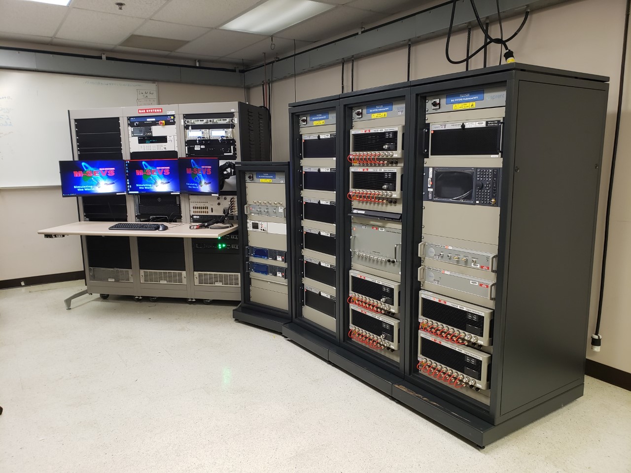
We integrate Spirent Federal and other signal simulators in both our test and development environments, where modeled RF signals are coordinated with other sensor measurements and host vehicle messages for high-fidelity hardware-in-the-loop test cases. Our engineers create hundreds of test cases and scripted test procedures to exercise our products under all required conditions. These simulations allow us to run thousands of trials to qualify and validate performance of our products in extreme scenarios.
BAE Systems’ hardware-in-the-loop simulation environments build upon Spirent Federal signal generators to test products under extreme dynamic and threat environments. (Photo: Spirent Federal)
Currently, 37 Global Positioning System satellites are on-orbit, with 29 of them set healthy. The system continues to provide an average 48-centimeter position accuracy. Despite this achievement, the U.S. government — specifically, the Space Force — continues to modernize GPS’s space, control and military user equipment segments.
Modernization of the space segment is centered on the GPS III satellites, which provide up to eight times better anti-jam capability and a new L1C signal to improve user connectivity. GPS IIIF satellites, scheduled for delivery starting in early 2026, will add a search-and-rescue payload, a fully digital navigation payload, and greatly enhanced anti-jam capability for military operations.
Modernization of the control segment is focused on the next-generation Operational Control System (OCX), scheduled to become operational early next year. OCX will sport an updated architecture to provide enhanced command-and-control capabilities and enhanced cybersecurity. Despite the pandemic, all 17 global OCX monitoring station installations were completed last summer, and most of the remaining equipment was fielded by the end of 2021.
Twenty-four GPS satellites are broadcasting the military code (M-code). The Modernized GPS User Equipment (MGUE) program is developing military GPS receivers able to take advantage of these signals to improve defenses against spoofing and jamming while allowing navigation warfare operations.
On the civil side, GPS modernization will play a key role in the development of the Next Generation Air Transportation System and intelligent transportation systems. The Department of Defense coordinates its GPS activities with the Department of Transportation (DOT), the Federal Aviation Administration (FAA) and many other federal departments and agencies via the National Executive Committee for Space-Based PNT. The term “space-based PNT” refers to GPS, GPS augmentations and other GNSS.
However, this government-wide coordination and cooperation is contradicted by the stand of the Federal Communications Commission (FCC) on the matter of Ligado Networks’ applications to modify its license for terrestrial service, which it approved in 2020. The FCC’s decision is opposed by the executive branch, represented by the National Telecommunications and Information Administration (NTIA), and by 14 federal agencies and departments individually (including the departments of Defense, Transportation, State, Treasury, Justice, Interior, Agriculture, Commerce, Energy and Homeland Security), as well as by the National PNT Advisory Board and by most GNSS receiver manufacturers and aviation organizations. NTIA took the unprecedented step of filing a still-pending petition for reconsideration with the FCC. The concern is that Ligado’s proposed transmission power exceeds the thresholds established by the DOT’s April 2018 GPS Adjacent Band Compatibility study to protect GPS users from harmful interference.
So, the list of threats to GPS now includes solar flares, spoofing, jamming, “legal jamming” by Ligado, and the Russian government’s recent threat to destroy GPS satellites. Modernizing GPS must proceed hand-in-hand with protecting it.
The U.S. Defense Logistics Agency has executed a $316 million contract option for BAE Systems’ advanced M-code GPS modules, raising the contract funding to $641 million.
The modules provide dependable positioning, navigation, and timing for ground troops, vehicles, aircraft and precision munitions. The contract will ensure the availability of Common GPS Modules (CGM) for advanced military GPS receivers with anti-jamming and anti-spoofing capabilities that enable operation in contested environments.
Under the contract option executed in November, BAE Systems will manufacture CGMs for future ground, airborne and weapon GPS receivers for the U.S. Department of Defense (DoD) and its allies. The award builds on a May $325 million contract and enables BAE Systems to continue to meet domestic and international demand for Military GPS User Equipment (MGUE) Increment 1 M-Code modules in GPS receivers through the end of the decade.
“Military operations require assured positioning, navigation and timing, and our customers are shifting to M-code to harden their GPS receivers against jamming and spoofing,” said Frank Zane, Navigation and Sensor Systems business development director at BAE Systems. “We’re ready to meet this need today with secure, reliable M-code GPS solutions, and we’re developing the next-generation of solutions to stay ahead of the threat.”
BAE Systems is delivering two advanced M-code GPS receivers: the Miniature Precision Lightweight GPS Receiver Engine – M-Code and the NavStrike-M GPS receiver.
Deliveries of the ultra-small MicroGRAM-M are expected in 2022, and deliveries of the Strategic Anti-jam Beamforming Receiver – M-Code are expected in 2024.
BAE Systems Inc. has received a $325.5 million contract from the Defense Logistics Agency for advanced military code (M-code) GPS modules that will provide reliable and secure positioning, navigation and timing data with anti-jamming and anti-spoofing capabilities.
The modules will help warfighters conduct operations in contested electronic warfare environments.
“Our state-of-the-art GPS technology works with the advanced military M-code signal to provide reliable information to the warfighters who depend on it,” said Greg Wild, director of Navigation and Sensor Systems at BAE Systems. “This contract will ensure the availability of M-code module inventory to build advanced, next-generation GPS receivers.”
Under the multi-year contract, BAE Systems will deliver Modernized GPS User Equipment (MGUE) Increment 1 Common GPS Modules (CGMs) compatible with the advanced M-code signal to support the U.S. Department of Defense and international allies through 2030.
BAE Systems will manufacture the modules, manage their inventory on behalf of the Defense Logistics Agency, and use them to build military-grade GPS receivers for ground and precision-guided munitions.
BAE Systems’ portfolio of M-code GPS receivers provides flexible, efficient, and reliable navigation and guidance solutions for airborne systems, precision munitions, handheld receivers, and embedded applications.
BAE Systems has received a $247 million contract from the U.S. Space Force’s Space and Missile Systems Center to design and manufacture an advanced military GPS receiver and next-generation semiconductor.
The technology will provide positioning, navigation, and timing (PNT) capabilities to warfighters so they can execute missions in challenging electromagnetic environments.
The Military GPS User Equipment (MGUE) Increment 2 Miniature Serial Interface program will provide improved capabilities for size-constrained and power-constrained military GPS applications, including precision-guided munitions and battery-powered handheld devices.
The program will focus on the certification of an advanced application-specific integrated circuit (ASIC) and the development of an ultra-small, low-power GPS module.
Both products will work with the next-generation military M-code signal technology, which provides reliable GPS data with anti-jamming and anti-spoofing capabilities to protect against electronic warfare threats.
“This program enables us to further develop our core M-code technology to deliver high-performance, next-generation GPS capabilities,” said Greg Wild, director of Navigation and Sensor Systems at BAE Systems. “Our M-code receiver and next-gen ASIC will enable secure and reliable military GPS capabilities in a broader range of platforms.”
BAE Systems’ Precision Strike business has 45 years of military GPS experience and more than 1.5 million GPS devices on over 280 platforms around the world. The company is currently producing M-code GPS receivers in multiple form factors, including a low power, small form factor M-code solution.
Additional prototypes are in development for ground, weapons and airborne mission applications, and the company’s M-code GPS products are available to U.S. allies via foreign military sales.
Work on the program will be conducted at the company’s facility in Cedar Rapids, Iowa.
Feature image: An Airman with the 374th Security Forces Squadron uses a Defense Advanced GPS Receiver (DAGR) to track the team’s current during a 2018 field training exercise at Camp Fuji, Japan. (Photo: Senior Airman Matthew Gilmore/U.S. Air Force)
Germany is the first United States ally to order the new military code (M-code)-capable Military GPS User Equipment (MGUE).
The Space and Missile Systems Center’s Space Production Corps achieved the major milestone on Sept. 30, when GPS Foreign Military Sales (FMS) office received its first M-code MGUE order.Germany is expected to receive delivery of its first M-code receivers this year.
SMC is facilitating international access and availability of M-code user equipment as directed by the Secretary of the Air Force and the Office of the Secretary of Defense to 58 authorized nations. Additional foreign military sales of MGUE are being worked.
Currently, SMC is engaged with several nations in bilateral M-code prototyping, demonstration and lead platform planning efforts. Under a multilateral agreement, MGUE ground-based receivers are on schedule to be loaned to approved partners for early integration and test in national weapons systems.
M-code is an upgrade to the currently available GPS signals that provides enhanced secure positioning, navigation and timing (PNT) performance, anti-jam and anti-spoofing to provide a more resilient PNT solution. It will improve interoperability with our defense partners’ equipment and operations while increasing navigation warfare effectiveness for allied operations.
Specifically, Booz Allen’s work will aid in the development and modernization of GPS systems through major programs such as Military GPS User Equipment (MGUE), GPS III and Next Generation Operational Control System (OCX).
The NIWC Pacific Positioning, Navigation, and Timing (PNT) Division is the Navy’s principal research and development center for navigation sensors and systems.
SMC is the center of technical excellence for developing, acquiring, fielding, and sustaining resilient and affordable military space systems.
With this contract, Booz Allen will continue to serve as a key mission partner for NIWC Pacific and SMC on the important endeavor of modernizing PNT systems for U.S. and Allied warfighters.
To execute this highly complex scope of work, Booz Allen will provide a range of essential services, including system definition, requirements synchronization, capability improvement, cybersecurity engineering, platform integration and testing, and acquisition program management.
“Booz Allen’s robust track record of work in both systems engineering and cybersecurity continues to inspire trust from our clients,” said Vice President Brian Zimmermann. “Our deep bench of leaders and technical experts reassures our clients that no project is too big or too complex. It’s our privilege to help the Navy and Air Force modernize GPS systems that are so vital to the security of our nation.”
Read more about Booz Allen’s work with PNT systems here.
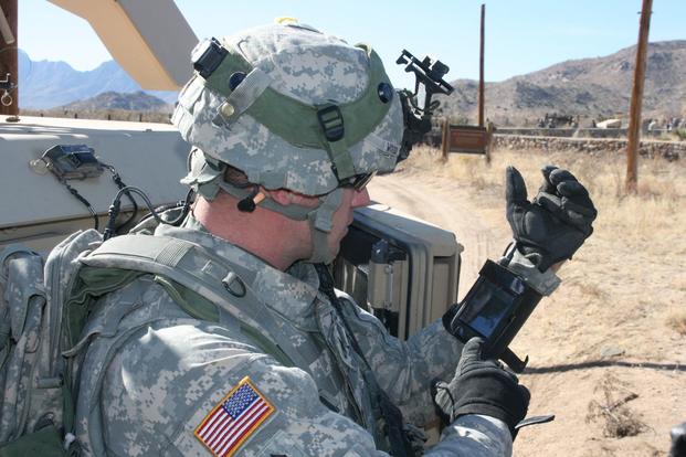
Staff Sgt. Reag Wood of 1st Combined Arms Battalion, 5th Brigade, 1st Armored Division, illustrates how he uses an iphone to obtain a visual image of a mock with insurgent activity during a field training exercise at White Sands Missile Range, N.M. (Photo: U.S. Army/Lt. Col. Deanna Bague)
Photo: U.S. Air Force / Staff Sgt. Scott H. Spitzer
Much development has been necessary to enable the new M-code capability on more than 700 weapon systems that require it. This article overviews M-code, the updates to antenna and receiver technology to make these varied platforms M-code ready, and perspectives from key stakeholders in the M-code community.
December 23, 2018, marked an important milestone for GPS. The successful launch of satellite USA-289 represented a key success in what has been a monumentally expensive government program, beset by delays and overspends.
The launch of the first GPS Block III satellite, the first that can provide the full military M-code capability, effectively commenced the physical roll-out of modern M-code hardware.
Ground Control. As far as the space segment is concerned, M-code is finally underway. What about the ground segment? The next-generation GPS operational control system, GPS OCX, is essential for use of the full capabilities of the new Block III satellites. It has been under development for some time.
OCX has drawn Congressional criticism and correlative media attention, but recent reports have been more positive. Since the Nunn-McCurdy breach of 2016, when the project’s future hung in the balance, accounts have grown gradually optimistic. Budget and schedule were re-baselined, and contractor Raytheon’s corrective actions generated results. In the fall of 2017 the Air Force took delivery of OCX Block 0, marking a significant milestone. Block 0, also known as the Launch and Checkout System (LCS), demonstrated compliance with contractual requirements and was accepted by the Air Force.
In spring 2018, Block 0 underwent a series of cybersecurity tests and passed, validating the security architecture of the system. All this puts Raytheon on track to deliver OCX Block 1 in 2021, providing full operational capability. Block 1 and Block 2 are intended to be delivered together, adding operational control of the modernized satellites and signals, including L1C and the modernized M-code.
“There have been no schedule slips with the GPS OCX program since 2017, and the GPS III launch last December was clear proof of our progress,” stated Dave Wajsgras, president of Raytheon’s Intelligence, Information and Services business. “We will continue to meet all of our commitments, and importantly, we will meet our June 2021 contractual deadline.”
Col. Steve Whitney of the GPS Directorate wrote in this magazine in December 2018 that “The journey over the past few years has been challenging, but we have emerged stronger, armed with better metrics, and a culture of integrated development (often called DevOps) which puts us on a path to success. There will be challenges and risks in the path ahead but rather than mountains to climb, I see these more as standard blocking and tackling of a software-intensive program.”
Meanwhile. The Air Force plans to deploy M-code capability in 2020, and OCX seems unlikely to be ready. For this reason, Lockheed Martin was awarded a contract to modernize the existing ground infrastructure as a “gap filler.”
The GPS Control Segment Sustainment II (GCS II) contract was awarded on Dec. 21, 2018, and is worth $462 million. GCS II will support operational capability of M-code in 2020, and continues until 2025, and so there will be a period of overlap between GCS II and OCX, essentially providing two options for controlling the new GPS III constellation. In one view, the Air Force is backing two horses to improve chance of winning: OCX the preferred solution, with GCS II almost like an insurance policy.
With the GPS III ground and space segments looking relatively healthy, attention turns again to the user segment.
WHY M-CODE?
Until now, the military has used the classic P(Y) signal: a binary phase shift keying (BPSK)-modulated encrypted wideband signal. It offers both greater accuracy and increased jamming resistance when compared to the civilian C/A code still employed by the vast majority of GPS receivers.
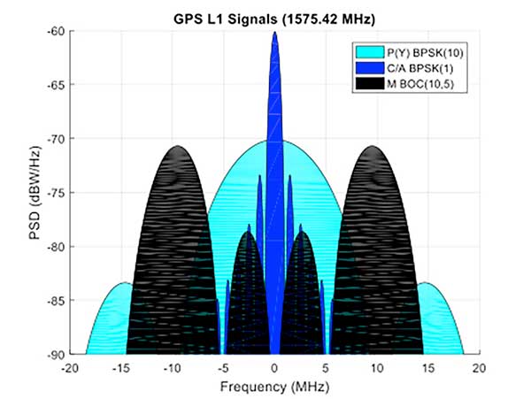
But the P(Y) code has its drawbacks in the modern world: its wide main lobe sits directly over the top of the C/A code signal (see Figure 1), essentially occupying the same spectrum. When the civilian C/A signal is jammed, the military P(Y) signal is at the very least degraded, if not also jammed itself. It also uses a relatively simple encryption scheme that does not meet today’s cyber security requirements.
Figure 1. C/A, P(Y), and M-Code signal power spectra. (Graphics: Mike Jones)
The M-code signal, on the other hand, is the first military GPS signal to use the BOC modulation scheme. BOC modulation gives signals their distinctive two-lobe appearance, spreading the signal’s energy away from the band center.
The wide spacing of the two sidebands separates the M-code signal from the civilian signals (the legacy C/A signal or the new L1C signal on the L1 frequency, and the L2C signal on the L2 frequency).
Amongst other things, this allows the military to jam the civilian codes without noticeably degrading the M-code signal. Often referred to as blue force electronic attack (BFEA), this is essentially a new facet to navigation warfare (NAVWAR), where enemy use of GPS can be denied whilst allowing friendly forces to continue using it.
The wider occupied bandwidth and increased signal power also help to make M-code more resistant to jamming. M-code also makes use of more modern and flexible encryption methods, ensuring it will be secure and safer from threats such as spoofing attacks.
Scepticism. Defense programs are known for their long procurement cycles, but even by these standards, M-code has taken an extremely long time to get where it is today. Given the enormous cost of the program, and the fact that there is still, as yet, no operational benefit to show from it, many people have questioned its worth. At the time it was conceived it represented a dramatic step forward in military capability but, because it has been so long in development, its operational benefit is becoming diluted.
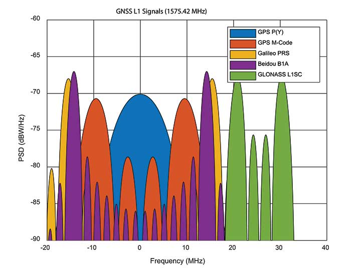
When M-code was conceived, GPS was still the only operational GNSS in town: everybody had to use GPS — or nothing. Today, the picture differs greatly. During M-code’s insanely slow progress, other GNSS systems have come along, offering their own encrypted signals of a similar ilk. Looking at Figure 2, M-code no longer appears as special as it once was. Its BOC(10,5) signal sits inside the main lobes of Europe’s Galileo PRS signal, which uses a BOC(15,2.5) scheme, and China’s Beidou B1A signal using BOC(14,2).
Figure 2. GNSS encrypted signals around the L1 frequency. (Graphics: Mike Jones)
If you were China, you might consider jamming the central 24 MHz of the L1 band, taking out M-code, whilst still having an operational military service for yourself. Or if you were Russia, you might jam 34 MHz of bandwidth, taking out the US, Chinese, and European systems, whilst still having your GLONASS L1SC military service to use. The situation is more complex than that, of course: each service has the potential to increase signal power in times of conflict, and there is more than one frequency that can be used. But it does demonstrate the essence of the problem: The modern battlespace has moved on, and M-code hasn’t.
CHALLENGES OF RECEIVER DESIGN
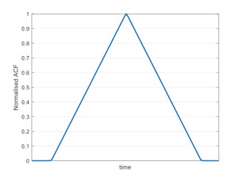
Figure 3. C/A code ACF.
With complex signals come complex receivers, and there several headaches when it comes to M-code receiver design. The first is the nature of the BOC signal itself, which has a complex correlation function. Consider Figure 3, which shows the autocorrelation function (ACF) of the traditional civilian C/A code signal. The single peak of the function makes acquisition and tracking a simple process; traditionally early, prompt and late (E,P,L) correlator arms can be used in the tracking process.
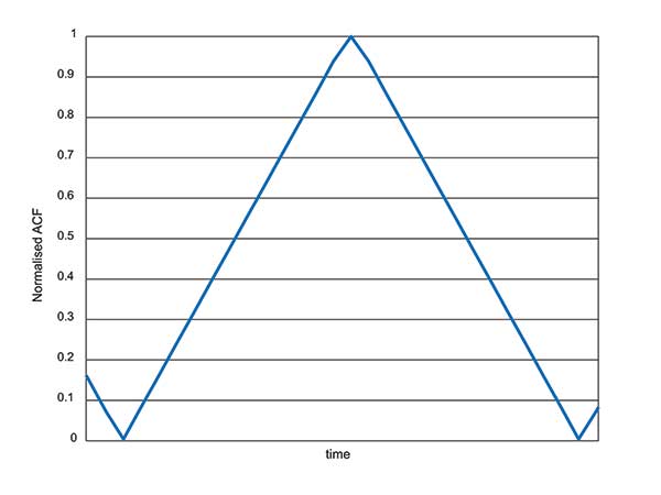
Figure 4. L1Cd ACF.
The newer BOC-type signals have a more complex ACF. Figure 4 shows the ACF of the new L1Cd civilian GPS signal, which uses a form of BOS(1,1) modulation. In addition to the main lobe, there are now two side lobes. Receivers must be careful not to lock on to one of the side lobes instead of the main lobe: the receiver architecture starts to become a little more complex.
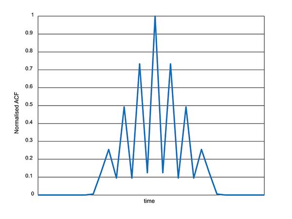
Figure 5. M-code ACF.
Now consider the ACF of the M-code signal, shown in Figure 5. Like other high-order BOC-type signals, M-code exhibits multiple lobes in the ACF, making robust acquisition and tracking a far more troublesome process. Furthermore, the high bandwidths require high sample rates, which lead to higher power consumption in the hardware.
Another major headache associated with M-code receivers is, of course, the encryption process. Not because encryption is difficult, but again because of the power consumption implications. Consider that each GPS receiver needs to run an encryption engine instance, for each satellite it might wish to receive. Running a high-grade encryption algorithm at a high chipping rate, for a dozen satellites, is a power-consuming process. For dismounted soldiers with limited battery capacity, this is a big deal.
Some people argue that the high-grade encryption process for M-code is too complex. Consider why we want to encrypt a GNSS signal in the first place: firstly to prevent someone from spoofing our signal, and secondly to prevent unauthorised users from using the service. Given that the encryption keys are rolled regularly, how much does it matter if an adversary manages to compromise the encryption? This isn’t a communications security problem: we are not talking about loss of classified information, so there’s an argument that a simpler, less power-hungry form of encryption might have been used instead.
ANTI-JAM ANTENNA COMPATIBILITY
Although M-code offers a certain level of jamming resistance, it is still vulnerable to attacks. As a signal it might have a bit more power, and a bit more bandwidth, than some other signals. But it is, after all, still a GNSS signal, and it can be jammed by an adversary. Where an operational threat analysis indicates that an increased level of jamming resistance is required, then M-code receivers need to be integrated with anti-jam antennas.
Anti-jam antennas, usually referred to in the GNSS community as controlled reception pattern antennas (CRPAs), have been the anti-jam tool of choice for several decades now. I overviewed these in an April 2017 newsletter column. CRPA manufacturers have had to ensure that their products are “M-code ready,” such that they can be seamlessly attached to M-code receivers as and when they appear.
This hasn’t been a recent process: as far back as 2002, the GAS-1 antenna (Raytheon) underwent a series of qualification tests to ensure compliance with M-code. Around 2005, the ADAP antenna (also Raytheon) was launched with a host of M-code features — again an illustration of just how slow the M-code program has moved, given that other technology has been “M-code ready” for 10 or 15 years already.
What’s involved in making a CRPA M-code compatible? Firstly the increased bandwidth: the antenna electronics must digitize the wider bandwidths. Along with the wider bandwidth comes new filtering shapes to ensure optimum performance.
Space-time adaptive processing (STAP) and space-frequency adaptive processing (SFAP) techniques potentially require more taps to ensure high null depths can be maintained across the full bandwidth. The increased power of the M-code signal, particularly if features like spot beam are used, presents another complication to CRPAs: they must not treat the high-power satellite signals as jammers, and try to remove them.
Testing CRPAs presents a challenge to manufacturers: how do you prove that your antenna doesn’t corrupt the M-code signal, when there’s no M-code signal to test it with? To work around this issue, pseudo M-code signals have been used for testing, where representative BOC(10,5) signals without the real encryption are passed through the CRPA and examined for distortion.
RECEIVER DEVELOPMENT STATUS
Due to the security considerations surrounding M-code, only three US organizations are authorized to produce modules: Collins Aerospace, Raytheon and L3. Here are the answers from Collins Aerospace and L3, the answers from Raytheon will appear in later issue.
What are the technical challenges associated with developing an M-code receiver?
Collins Aerospace. The Collins Aerospace Modernized GPS User Equipment (MGUE) Increment 1 development like the SAASM PPS receiver developments faced very challenging technical requirements to support our war fighter needs in an ever-evolving threat environment. Like other complex developments the challenges are initially technical and then transition to integration/test and certification. On the technical front optimizing receiver performance balanced against power consumption are always at the forefront. In addition, it is important to maximize backwards compatibility so as to minimize downstream integration costs while adding an entirely new signal that runs in parallel to the existing system. Collins Aerospace is pleased with the technical development and are actively supporting the integration with both receivers and technical support.
To date, we have delivered more than 770 MGUE receivers to the Air Force to support Air Force, lead platform and DoD-wide Integration and test. Soon the total will grow to nearly 1,100 receivers to support expanded integration and test following the completion of Collins Aerospace security certification.
L3. M-code GPS User Equipment (MGUE) technologies exist today.L3’s Ground Based GPS Receiver Application Module – Modernized (GB-GRAM-M) is a fully-functioning unit that is currently baselined and undergoing an independent Technical Requirements Verification (TRV) by the GPS Directorate.During TRV, each requirement from the Technical Requirements Document (TRD) is independently evaluated for compliance. Upon completion of the TRV, the design is baselined with complete documentation enabling platforms and prime equipment to integrate from a known baseline with low risk. Following integration, operational testing can start immediately to support fielding when M-Code Early Use (MCEU) becomes operational. The TRV of L3’s GB-GRAM-M is planned to be completed by the second quarter of 2019.
L3 resolved numerous technical challenges in developing M-code GPS technologies. The first and ever-present challenge is changing and evolving requirements. Most of these requirement changes are in response to evolving threats that have driven changes into the GPS receiver and/or to higher-level systems. Asan example, the U.S. Army’s Assured PNT (A-PNT) is implementing M- code GPS along with external sensors to establish and maintain an assured solution even in GPS-challenged environments. Other challenging requirements include meeting the security requirements, implementing and testing anti-spoofing algorithms, and ensuring backward compatibility with legacy receivers.
What are the intended platforms for your MGUE?
Collins Aerospace. The Collins Aerospace MGUE receivers are intended to support all warfighter domains: ground, airborne, maritime and munitions to support compliance with Public Law 111-383 SEC. 913 issued in Fiscal Year 2011. Per this directive, M-code is intended for all DoD applications with the exception of passenger vehicles or commercial vehicles with GPS installed. Now that the satellite and control segments of the capability are coming on line, we are working diligently to ensure that user equipment is available for all domains.
L3. L3 has products to meet current market demand. Under the MGUE program, L3 developed a GB-GRAM-M, which is a standard Modular Open Systems Architecture (MOSA) design. The GB-GRAM-M is designed to fulfill retrofit replacements of SAASM receivers, as well as being a primary component of A-PNT systems. L3’s M2GRAM ASIC is the core of our receiver, a GPS module that incorporates signal processing, cryptography, and positioning, velocity, and timing (PVT) processing. The M2GRAM ASIC is capable of being implemented in other form factors for applications beyond ground-based applications. As an example, the M2GRAM is implemented in a GPS receiver specifically designed for Precision Guided Munitions (PGM) applications and was used in a gun launched, guide-to-target demonstration operating as a PGM receiver.
L3 is also augmenting the GPS receiver through the integration of several other technologies, including controlled reception pattern antennas with digital antenna electronics, inertial systems and external sensors, and GPS-denied capabilities. M-code technologies are being implemented in Mounted A-PNT Systems (MAPS), Dismounted A-PNT Systems (DAPS), and handheld systems to bring capabilities to the warfighter.
What is the expected timeline for your MGUE development, acceptance testing, and delivery?
Defense Advanced GPs Receiver (DAGR) from Collins Aerospace, equipping infantry and other warfighters. (Photo: Collins Aerospace)
Collins Aerospace. The Collins Aerospace receivers are supporting ongoing DoD integration and test and our MGUE Increment 1 program is aligned with the Air Force GPS Enterprise roadmap. Ultimately, the Department of Defense (DoD) M-code programs will set the production delivery schedules.
We anticipate that the M-code production ramp-up and continued SAASM PPS receiver production will have a production overlap. Our Collins Aerospace in-house PPS GPS receiver manufacturing capability is ready to support the DoD demand for both M-code and SAASM. Collins Aerospace is fully committed to manufacturing Increment 1 M-code receivers to meet the warfighter’s needs across Airborne, Weapons and Ground, we know the transition from SAASM to M-code will take years. Therefore, Collins Aerospace will continue to manufacture SAASM receivers for years to come as the International MOD Policy for M-code use is still being formulated.
L3. L3’s GB-GRAM-M is now available. L3 received security certification and approval in 2016 and TRV is planned for completion in the second quarter of 2019. With TRV, L3 is receiving a new security certification and approval of the latest receiver update. Government agencies, prime contractors and laboratories can order GB-GRAM-M now with delivery in the fourth quarter of 2019.
What does testing and verification process involve?
Collins Aerospace. As with any Precise Positioning Service (PPS) GPS development, the testing involves functional verification of the receiver in a wide variety challenging of environmental, thermal, electromagnetic interference/ high-intensity radiated field (EMI/HIRF) environments. Collins Aerospace is leveraging proven test and verification approaches founded upon our long history of successful product introductions and field performance. As this is a PPS receiver it is also essential the receiver design comply with the government’s required Security Approval process.
L3. The testing and verification of L3’s GB-GRAM-M included internal testing and independent testing through the GPS Directorate’s TRV process. Further risk reduction testing within the MGUE program is planned as Phase IV testing where the GB-GRAM-M is integrated into a lead platform for the U.S. Army and a lead platform for the U. S. Marine Corps. An operational assessment is performed on both lead platforms to assure common problems associated with integration and operational testing are addressed prior to implementing M-Code GPS Receivers across all of the platforms.
Will the MGUE be compatible with CRPA anti-jam antennas; are there any special considerations for this?
Collins Aerospace. The Collins Aerospace product family includes our Digital Integrated Anti Jam Receiver (DIGAR) product family that leverages CRPA anti-jam antennas for enhanced anti-jam (AJ) performance. Our DIGAR AJ technology enhances the performance with fixed reception pattern antenna (FRPA), CRPA and is compatible with all PPS waveforms. Regarding the interfaces between the receiver and the anti-jam antenna electronics, a GPS receiver with a standard RF interface is compatible with a CRPA in nulling mode and FRPA antennas. Advanced capabilities such as beamforming/beamsteering require tight coordination and additional interface with the GPS receiver.
L3. The GB-GRAM-M is designed to operate with a fixed reception pattern antenna (FRPA). A CRPA antenna using digital antenna electronics to generate signals matching the characteristics of a FRPA is fully compatible with the GB-GRAM-M. With a higher level of integration of a GPS receiver and a CRPA, the system capabilities are greatly enhanced. L3 has performed this integration and can perform advanced capabilities such as angle of arrival and beamforming using M2GRAM, digital antenna electronics, and CRPA technologies. These capabilities can be found in L3’s Mounted Assured PNT System (MAPS) and Anti-Jam Antenna System (AJAS) products.
Army Stryker ground combat vehicle. (Photo: Karolis Kavolelis / Shutterstock.com)
OPERATIONAL DEPLOYMENT
The U.S. Air Force GPS Directorate provided answers to the following questions regarding MGUE.
Which platforms will be equipped with M-code-capable MGUE, and how many of each?
GPS Directorate. The Air Force is developing M-code-capable GPS receivers under the MGUE Increment 1 program. The receivers in development will be provided to four service-specific lead platforms for integration, developmental, and operational testing. Lead platforms are:
the Army Stryker ground combat vehicle,
the Air Force B-2 Spirit bomber,
the Marine Corps Joint Light Tactical Vehicle (JLTV),
and the Navy Arleigh-Burke class destroyer (DDG).
Following the lead platform efforts, procurement of M-code-capable GPS receivers will be decided by the Services and executed by individual platforms and programs.
What are the timelines for rolling out M-code on these platforms?
GPS Directorate. Early integration and test activities have already begun for each MGUE lead platform. Operational testing is expected to begin in 2020 and complete in 2021, which is a key activity to enable the fielding of M-code-capable systems.
B-2 Spirit multi-role bomber capable of delivering both conventional and nuclear munitions. In December 2017, the Air Force completed a series of successful flight tests of M-code GPS using a Raytheon Company receiver on board a B-2 Spirit at Edwards Air Force Base, California. (Photo: U.S. Air Force/Bobby Garcia)
What advantages will M-code bring, over existing military GPS receivers?
GPS Directorate. Modernized GPS receiver cards under development with the Air Force MGUE Increment 1 program will enable the use of M-code and provide U.S. forces with enhanced position, navigation, and timing capabilities, in addition to improving resistance to threats, such as jamming efforts by adversaries.
How will keys and key distribution be managed?
GPS Directorate. None of this is publically releasable.
Will M-code be made available to other friendly nations? If so, how is this managed?
GPS Directorate. The current policy allows for the sale of M-code equipment to all 57 authorized GPS PPS nations. The M-code technology will be made available to these nations through the Foreign Military Sales process.
USER PERSPECTIVE
The Department of Defense supplied answers to the following questions for users and warfighters.
What are the benefits you perceive will come from new M-code GPS equipment?
DoD. Provides U.S. forces with enhanced position, navigation, and timing capabilities, in addition to improving resistance to threats, such as jamming efforts by adversaries.
Will it change how you perform military operations, or enable any new ones?
DoD. Modernized GPS receivers provide the next-generation GPS capabilities to the warfighter. Operational testing will enable the services to determine operational utility of MGUE. It will ensure our soldiers, sailors, airmen, and marines have the ability to get in, accomplish their mission, and get home accurately.
How will M-code-based GPS receivers be brought into operational service? Will there be a mass upgrade of assets, or a phased introduction?
DoD. Procurement of M-code-capable GPS receivers will be decided by the Services and executed by individual platforms and programs.
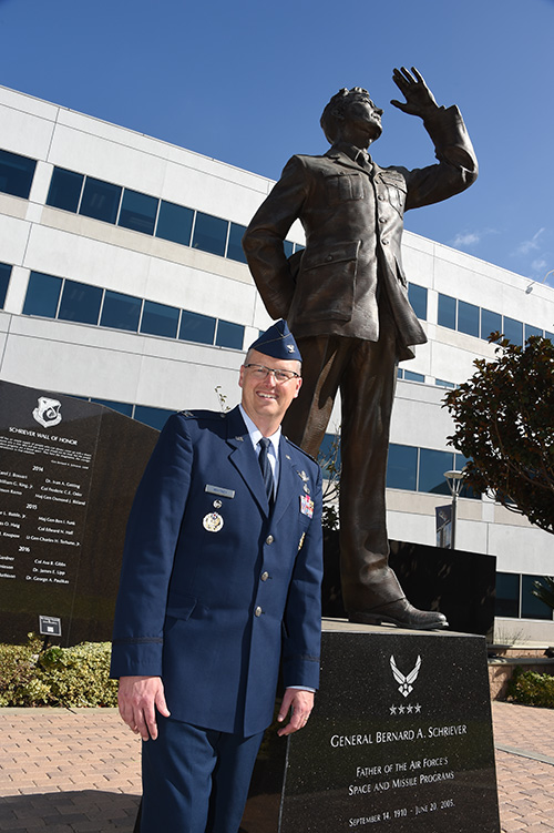
Col. Steve Whitney stands beside a statue of General Schriever at Los Angeles Air Force Base, home of the GPS Directorate. (Photo: U.S. Air Force/Joseph Juarez, Sr.)
By Col. Steven Whitney Director, Global Positioning Systems Directorate
Navigating across the world’s roads with GPS is easy. Navigating through the shifting construction zones, detours, and forks of the GPS Enterprise is not always so straightforward.
For that reason, the GPS Directorate has placed more emphasis on illustrating, both figuratively and literally, the roadmaps leading to the integration of the GPS Enterprise.
Before linking everything together, let’s start with an update on each major program effort. This way you can zoom out to see the path ahead; hopefully minimizing any “route recalculating” along the way.
Program Updates
The journey to build the new GPS III satellites has been full of twists and turns but we are now close to our destination – in this case the GPS orbit of 12,550 miles above the Earth.
We not only have 10 GPS III Space Vehicles simultaneously in production at Lockheed Martin’s manufacturing facility in Waterton, Colorado, but are also going full swing on preparations to launch our first vehicle in December 2018 on a SpaceX Falcon 9 rocket – more on this later. The GPS III satellites provide signals designed to improve the user’s ability to navigate.
In addition to the increased power and greater accuracy, GPS III adds a civil new signal, L1C, designed for compatibility with the international Global Navigation Satellite Systems (GNSS) community.
GPS IIIF. In September 2018, the Air Force awarded the GPS III Follow-on contract to Lockheed Martin. This $7.2B contract for 22 satellites was the result of a competitive process for a production effort. Based on the GPS III technical baseline, the GPS IIIF family of satellites embraces modernization and capability improvements in multiple areas.
First, a Regional Military Protection capability will provide increased anti-jam capabilities. Furthermore, a new Search-and-Rescue (SAR/GPS) payload will provide improved timeliness of global search-and-rescue operations. Additionally, a Laser Retro-reflector Array (LRA) payload will enable precise ranging measurements and the program will implement a Unified S-Band capability to address consolidation of telemetry, tracking, and commanding frequencies.
Finally, the program will host a redesigned Nuclear Detonation (NUDET) Detection System (NDS) solution that has a lower overall size and weight. We look forward to the continued partnership with Lockheed Martin and will be looking collaboratively at opportunities to add additional capabilities incrementally over the life of the 22 GPS IIIF satellite production line.
OCX, the Next Generation Operational Control Segment. Last year Raytheon delivered the initial system, known as OCX Block 0, to support the launch and on-orbit check-out of the GPS III satellites. This past year, we have actively utilized the system in a variety of exercises, training events, compatibility tests, and launch readiness events.
We also completed a comprehensive security review of the system to demonstrate our readiness to start operations. The system is ready to go. We continue to work the development of the OCX Block 1 system and are wrapping up the initial coding of the system early in 2019, leading into our integration and test campaign.
The journey over the past few years has been challenging, but we have emerged stronger, armed with better metrics, and a culture of integrated development (often called DevOps) which puts us on a path to success. There will be challenges and risks in the path ahead but rather than mountains to climb, I see these more as standard blocking and tackling of a software intensive program.
Col. Whitney next to an artist’s depiction of a GPS III satellite in orbit. (Photo: U.S. Air Force/Van Ha)
Legacy Ground Sustainment. Running in parallel to these modernization efforts is the all-important work to sustain our existing GPS infrastructure of our current Operational Control System (OCS). These sustainment efforts ensure GPS continues to be the gold standard in positioning, navigation, and timing but also are a crucial “on-ramp” to facilitate a smooth merge onto the modernized GPS capabilities.
Since 2014, the GPS program office has incrementally implemented several upgrades that not only maintain our satellite constellation delivery of GPS signal-in-space accuracy of 50 cm, but also significantly increases the cybersecurity posture of the legacy OCS.
These upgrades culminated with a deployment of the latest modification in October 2018, which finished a worldwide modernization of our entire control system hardware and software. This latest upgrade, known as Version 7.5, virtualized the network, implemented two-factor authentication, and improved encryption for mission data.
Legacy Ground Improvements. Given the delays in OCX, the Directorate is actively working two major upgrades to OCS to bridge the gap. The first is GPS III Contingency Operations (COps) modification which will allow the 2nd Space Operations Squadron (2SOPS) to command and control the GPS III family of vehicles in a mission state matching today’s legacy signals for all users world-wide. The second modification is M-Code Early Use, which enables 2SOPS to operationalize the Modernized GPS military signals (M-Code) navigation signals for the warfighter.
User Equipment. As I write this article, soldiers, sailors, marines and airmen are testing and integrating mature, next-generation GPS receiver cards providing more accurate and reliable position, navigation, and timing (PNT) solutions. In 2019, the first increment of Military GPS User Equipment (MGUE) is on track to complete card-level testing to inform Service procurement strategies.
This exciting work is the culmination of nearly two decades of modernization efforts throughout the GPS Enterprise. In the near term, we are utilizing M-Code capable lead platforms — USAF B-2 Bomber, USMC Joint Light Tactical Vehicle, USN Arleigh-Burke Class Guided Missile Destroyer, and Army Stryker combat vehicle — to prove out those capabilities.
The second increment of MGUE focuses on requirements for precision guided munitions, a joint common modular handheld unit, as well as circuit cards and components for low size, weight and power needs. With MGUE, the DoD and services are poised to have enduring PNT solutions the warfighter can leverage for years to come.
Integration Roadmaps
The delivery of individual programs is the stepping stone in the capability deliveries to the warfighter and our civilian users. However, it is our ability to unite a diverse collection of programs and stakeholders, across the GPS Enterprise, which defines our success as the GPS Green Monsters. We have done this by linking cross-program enterprise teams so the sum of the whole is greater than its parts.
Enterprise Road to Launch (ERTL). The goal is pulling together a series of firsts (new satellite, new ground system, and new launch provider), which has not been done before in the modern GPS Era, to deliver the spacecraft safely on-orbit and under control. Our journey to this historic launch has taken time and effort, and we are enthusiastically awaiting the final steps.
The first GPS III spacecraft is safely at Cape Canaveral and ready to go. The control system has been tested and run through its paces. The integrated launch team has conducted its exercises and reviews. All signs point to launch in December 2018.
The launch itself is a significant milestone, and marks a beginning of the orbital phase of GPS III. The Road to Launch team is prepared to execute the launch, the check-out and the day-to-day on-orbit housekeeping until the ground updates are complete to transfer the new GPS III satellite into the active constellation later in 2019.
Enterprise Road to Mission (ERM). The goal is bringing the GPS III satellites into the active constellation providing mission similar to today’s capabilities. A key enabler of the ERM IPT’s success is their development of the first-ever Enterprise “Integration Playbook”, which is the tangible, documented output of a significant dedicated planning effort.
The Playbook captures how all the pieces and efforts from each stakeholder community tie together to achieve Operational Acceptance of the first GPS III satellite, the USNDS payload, and the COps modification to OCS. The “Playbook” describes in clear and concise terms how these deliveries integrate across the GPS Enterprise, as well as how tasks and milestones from various stakeholders converge to achieve clear end states.
Enterprise Road to M-Code Mission, or ERM-M-Code. Shifting now to our military users, the purpose of the ERM-M-Code team is to lead the early delivery of a more robust, resilient, jamming/tampering-resistant PNT signal capability to warfighters.
The rollout of the operational M-code capability depends on the success of the M-Code Early Use modification to OCS, installation of new M-code signal monitoring equipment at sites around the globe, modification of mission planning software, Military GPS User Equipment Increment 1 development, service lead platform integration efforts, and operationalization of space receivers.
Our ultimate objective is to improve the ability of the Combined Space Operations Center (CSpOC) to respond to urgent PNT needs of the combatant commanders, as they engage more sophisticated adversaries. We remain closely aligned with our peers at USSTRATCOM, AFSPC and user communities.
Conclusion
It is an exciting time to be a GPS Green Monster! These roadmaps are by no means easy to create and execute. It is thanks to the remarkable people of your GPS Directorate that these multifaceted challenges are unraveled, aligned, and resolved. The team has worked incredibly hard this past year to position our systems for major, integrated deliveries over the next couple of years.
It has been the highlight of my career to serve with these men and women and I can’t wait to see where we — and the GPS Enterprise — go next.