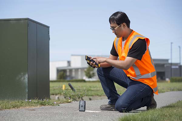
TDC’s Freeance field applications leverages Trimble GNSS for accurate, streamlined data collection
TDC Group has joined Trimble’s GIS (geographic information system) Business Partner Program. As part of the program, TDC has implemented the Trimble Precision SDK (software developer kit) to integrate high-accuracy positioning capabilities in its Freeance mobile software applications running on tablets and smartphones using Trimble GNSS receivers.
Freeance provides field crews with simple yet powerful and configurable location-based mobile apps to manage data collection and inspection activities across utility and public works organizations. By adding the Trimble R1 and R2 receivers to Freeance workflows, users are empowered with real-time access to high-quality, reliable data.
The Trimble R1 receiver will be accessible with TDC’s Freeance software. (Photo: Trimble)
“Trimble recognizes the value our GIS software partners bring to our customers by delivering targeted, industry-specific solutions,” said Stephanie Michaud, strategic marketing manager, Trimble Survey & Mapping Field Solutions. “We’re very pleased to collaborate with TDC and leverage their domain expertise, and to integrate Trimble technology into the Freeance solution for the utilities and public works markets. As a direct result of this relationship, Freeance users can now work with the confidence of knowing their field workflows are precision-enabled with Trimble GIS technology.”
“We’re excited about the integration of high-accuracy Trimble GNSS receivers with Freeance software that enables organizations to add sub-meter or better accuracy to mobile workflow activities using smartphones and tablets,” said Matthew Reddington, CEO of TDC Group. “Adding high-accuracy positioning to field workflows by means of simple mobile apps paired with Trimble GNSS increases the quality and uses of data captured during field operations.”
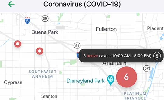
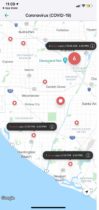
Vesedia Mobile Technologies is offering to deploy its location platform to help control the COVID-19 pandemic through tracking and dissemination of information about “at risk” infection areas and places, and times when they were known to have infection — a process referred to as contact tracing.
Vesedia is a technology startup with a suite of mobile apps for children and family safety based on a location-sharing platform and location-tracking artificial intelligence (AI).
“The platform would warn people that passed through these places at matching times,” explained Ruslan Shalaev, co-founder and team leader, Vesedia. Shalaev developed a popular app for family safety: Safely – Family Location; and serves as a lead research on user-location monitoring AI in an academic partnership with Binghamton University and Lviv National University.
The Safely – Family Location app could be used to disseminate data on infection areas, and access to the API would be provided for other application developers and sites, Shalaev said.
The platform would be applicable after the initial pandemic is contained. “It would help with restarting the economy and resuming normal business operations by providing a mechanism to track, control and suppress new outbreaks,” Shalaev said.
Data Sources
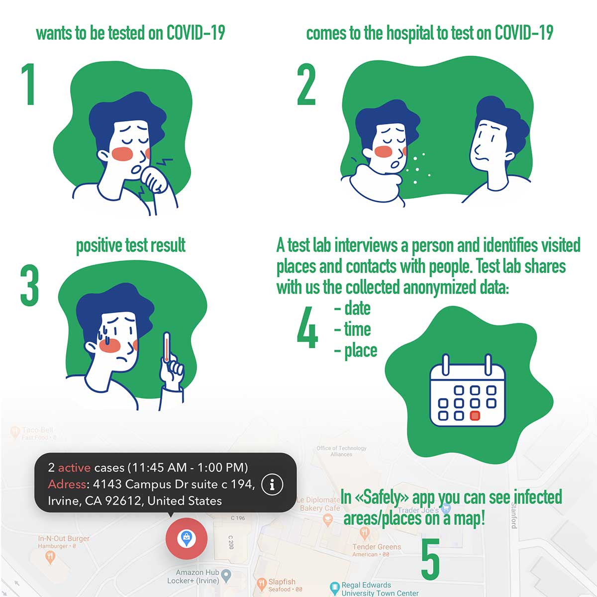
Under the plan, people that test positive to COVID-19 would be asked to provide information about public places they visited in the preceding days, and at what times. Individuals that provide the information can confirm that it’s accurate from their phone location history.
The information would be anonymized by healthcare officials, and entered into a database that would be publicly accessible via a website and mobile app.
Image: Vesedia
Mobile App
The mobile app aspect is especially valuable from information dissemination standpoint, because other people in “at risk” areas can receive automated alerts to self-quarantine and get tested based on their device location history.
The app is ready and available for download in Google Play and Apple App Store.
Image: Vesedia
Image: Vesedia
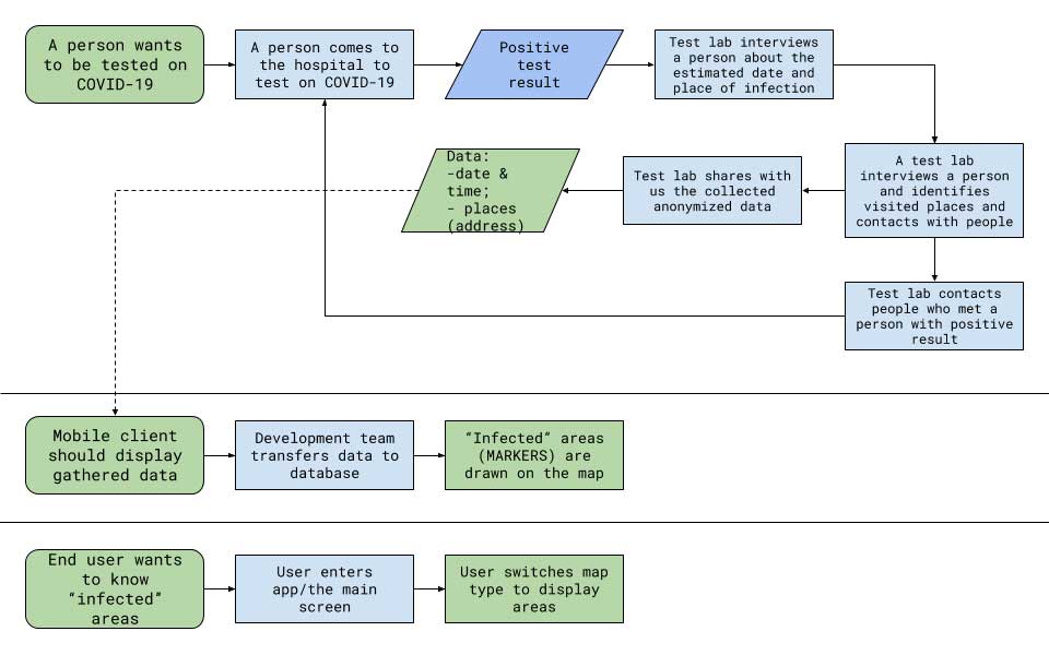
Workflow diagram
Workflow diagram. (Image: Vesedia)
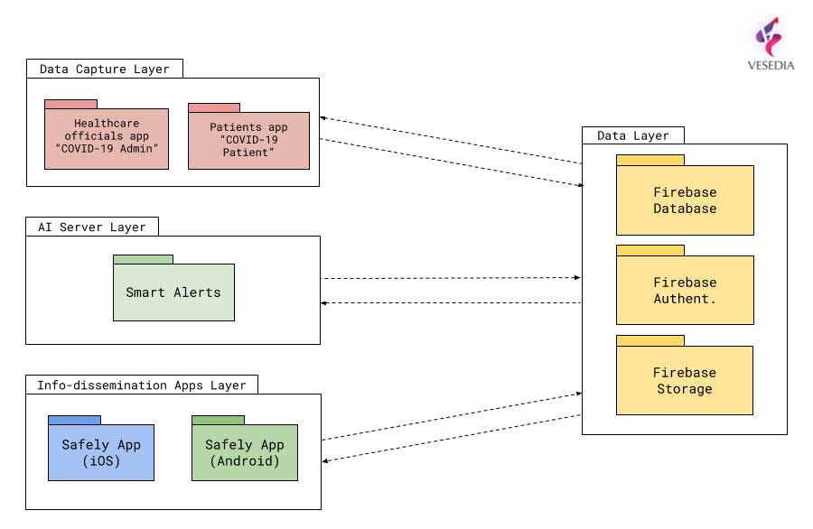
System architecture
System architecture. (Image: Vesedia)
Approach validity
The approach has been successfully applied in Singapore, but without active alerts, with dissemination of information being done manually. The Singapore government was able to contain the virus without shutting down businesses, schools, public transit and restaurants.
Vesedia location apps
Vesedia is a tech startup founded in 2016 by SUNY Binghamton Computer Science graduates. It developed SmartAI location tracking and sharing platform. Its apps include Safely – Family Location, Virtual Nanny, MeetCity – Live Events, Blind Date, Sponter – Social Network in partnership with Lviv National University and Binghamton University. The apps are available for download in the Google Play and Apple App stores.
Vesedia research on “Location-Based Behavioral Patterns Modeling” was published at Institute of Electrical and Electronics Engineers – Intelligent Data Acquisition and Advanced Computing Systems (IEEE/IDAACS) conference in Metz, France in 2019.
A team of medical researchers and bioethicists at Oxford University published results in Science that offer further understanding of coronavirus transmission.
The evidence is enabling several international partners to assess the feasibility of developing mobile apps for instant contact tracing in record time.
If rapidly and widely developed, the mobile apps could help to significantly slow transmission rates and support countries emerging from lockdowns as restrictions are gradually eased.
Partners include the Norwegian Institute of Public Health (FHI) and NHSX, a joint unit comprised of teams from NHS England and the UK’s Department of Health & Social Care.
Critically, the researchers suggest a mobile app can help slow the spread of infection until vaccines and antiviral treatments become widely available.
“We need a mobile contact tracing app to urgently support health services to control coronavirus transmission, target interventions and keep people safe,” explained Christophe Fraser, Oxford University’s Big Data Institute, Nuffield Department of Medicine, an a lead author on the Science paper.
“Our analysis suggests that about half of transmissions occur in the early phase of the infection, before you show any symptoms of infection,” Fraser said. “Our mathematical models also highlight that traditional public-health contact tracing approaches provide incomplete data and cannot keep up with the pace of this pandemic.”
The project is co-led by David Bonsall, senior researcher at Oxford University’s Nuffield Department of Medicine and clinician at Oxford’s John Radcliffe Hospital. “The mobile app concept we’ve mathematically modeled is simple and doesn’t need to track your location,” Bonsall said.
Anonymous alerts
“It uses a low-energy version of Bluetooth to log a memory of all the app users with whom you have come into close proximity over the last few days,” Bonsall said. “If you then become infected, these people are alerted instantly and anonymously, and advised to go home and self-isolate.
“If app users decide to share additional data, they could support health services to identify trends and target interventions to reach those most in need,” Bonsall said.
The authors argue that a mobile app can reduce transmission at any stage of the epidemic: in countries or regions where the epidemic is just emerging, at the peak of the epidemic, or to support a safe transition out of restricted movement or lockdown.
It could also help to reduce the serious social, psychological and economic impacts caused by widespread lockdowns. Critically, the researchers suggest a mobile app can help slow the spread of infection until vaccines and antiviral treatments become widely available.
Good citizenship
“A contact tracing app can foster good citizenship by alerting people at risk,” Fraser explained. “It can also help ease us out of confinement if we know we’ve not been in contact with anyone infected we can leave home safely, whilst still protecting our loved ones and avoiding a broader resurgence of coronavirus in our community.”
Given the level of infection across much of Europe, the team believe ongoing development of a mobile app partnership across the union would massively reduce transmission and avoid a resurgence in the number of cases, providing an opportunity for all citizens using mobile contact tracing apps to contribute towards ending the epidemic. An app strategy could also be used by low- and middle-income countries, earlier in the epidemic, to rapidly control transmission and get ahead of the epidemic now.
The Oxford team highlight that the mobile contact tracing app should still be combined with isolation of cases, tracing and quarantine of contacts, physical distancing, scaled-up diagnostic testing, decontamination and hygiene measures.
As Bonsall explains “If the mobile app is widely adopted in any country, and combined with other critical interventions such as physical distancing and widespread testing, our models suggest the epidemic could be brought under control. This app is a tool for each and every person affected to contribute towards protecting their health services, supporting vulnerable people and simultaneously gradually releasing communities out of extended quarantine.”
Rigorous ethical standards
Today’s Science study highlights the importance of rigorous ethical standards underpinning the successful and appropriate use of mobile phone technology in addressing the coronavirus pandemic, including a number of ethical requirements needed to foster well-founded public trust and confidence.
“With transparent and inclusive ethical oversight to ensure genuine public trust, it is possible to both save lives and protect civil liberties,” said Michael Parker, director of the Wellcome Centre for Ethics & Humanities and one of the paper’s authors.
“The app should be opt-in, provide secure data storage and privacy protection, and be informed by public and user engagement at every stage of implementation. With these guarantees and, if widely installed by users across a country or regional bloc, a mobile app could even help to end the epidemic,” Parker said.
Official apps only
As mobile apps launch over the coming weeks and months, the Oxford research team urges people to support official apps, developed by trusted institutions, and their partners, such as the mobile contact tracing apps under advanced assessment in several European countries.
Fraser concludes, “Our hope is to support communities with life-saving information as the pandemic worsens and help to release countries from large-scale isolation. The maths is clear: the more people that use a contract tracing app the better chance we have of getting ahead of this epidemic and eventually stopping it in its tracks. If a country reduces the epidemic growth rate to below zero, the epidemic will rapidly decline and eventually stop. Together we can make this possible.”
Download results
Results of a mobile-app-focused survey from a large representative sample of the UK population (1,055 respondents) conducted March 20-22 are available here. Other country surveys are also available for Italy, Germany and France, currently in each language.
The European GNSS Agency, based in Prague, is providing on its website a list of location-enabled applications that it considers potentially useful in response to the COVID-19 pandemic.
The applications range from those helping public authorities understand the dynamics of the outbreak to supporting citizens in their everyday lives by checking supermarket lines.
The apps are sorted into four categories:
Tracking the COVID-19 pandemic
Queue management
Response management
Information dissemination
If you are an application developer and you want to add your app to the list, contact [email protected].
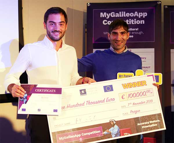
The winners of this year’s MyGalileoApp competition were announced at a ceremony held at the European GNSS Agency (GSA) headquarters in Prague on Nov. 7.
First prize of EUR 100,000 went to ARGEO, a mobile app based on geolocation, augmented reality and blockchain that allows users to discover content such as prizes, coupons and shopping cards geo-located around the streets of a city.
Second prize, worth EUR 50,000, went to the Tractor Navigator app, which provides guidance for farmers driving tractors, enabling them to visualise their position and trajectory in an open field. Finally, the EUR 30,000 third prize went to Ready Park, an app that makes parking easier by pairing drivers leaving a spot with users looking for one.
The 10 finalists from eight countries made their pitches to a panel of jurors throughout the afternoon of Nov. 7, after which the jury reached its decision on the winning apps.
Welcoming the competitors to the finals, GSA Executive Director Carlo des Dorides noted that the 10 finalists had been selected from a total of 150 competing teams, representing more than 35 nationalities.
“The MyGalileoApp competition is the largest app development competition ever organised within the Galileo programme. After reaching 1 billion smartphones equipped with Galileo earlier this year, the next big challenge is to develop applications that will make best use of the Galileo differentiators,” des Dorides said.
Following the pitches was an investors’ panel, with presentations by experts from various institutions, including venture capital firms and accelerators, providing information on how apps can bridge the gap between great ideas and viable business opportunities.
“Private and public investors will have an opportunity today to expand their investment portfolio with the Galileo apps generated by the competition, helping to transform the apps into commercial successes,” des Dorides said, adding that the goal of the MyGalileoApp competition was not just to make beautiful apps, but to create jobs and generate economic growth. For a full agenda of the day’s events, click here.
From left: Left to Right: Esri Director of Global Business Development Jeff Peters, Eos Sr. Marketing & Content Strategist Sarah Alban, Eos CTO Jean-Yves Lauture, Esri President Jack Dangermond. (Photo: Eos Positioning)
The award for “Energizing the Market with a Bundle” recognizes Eos’ seamless integration of its Arrow Series GNSS receivers with Esri mobile apps.
Eos Positioning Systems Inc., provider of submeter Bluetooth GPS and GNSS solutions, has received a 2019 Esri Partner Conference award in recognition of Eos’ contributions to Esri mobile applications.
Esri ArcGIS users benefit from bundling the Eos Arrow GNSS receivers and Esri mobile apps to create real-time, high-accuracy field GIS solutions on consumer devices such as iPads, tablets, and smartphones.
Photo: Eos Positioning
“As a long time Esri partner, this ‘Energizing the Market Award’ highlights the ongoing value Eos brings to our shared customers,” said Francis Kelly, Esri manager of Global Partner Programs. “Their thoughtful approach to connecting the field worker to the enterprise GIS creates customer satisfaction and significant ROI across our business sectors.”
“Eos has done tremendous work bringing affordable high-accuracy receivers to the Esri user community, whilst taking advantage of the latest Esri technology including Collector for ArcGIS and Survey123 for ArcGIS,” Esri Canada Director of Strategic Alliances Paul Salah said. “I couldn’t be more pleased to have them recognized for their innovation that brings such great value to field workers everywhere.”
Eos’ mission is to turn the complex world of high-accuracy submeter and RTK location into simple and affordable integrations to the Esri ArcGIS platform. This is achieved with behind-the-scenes transfers of high-level GNSS information with Esri mobile apps.
The exchange is nearly transparent to the end-user, and therefore minimizes the knowledge required for anyone to capture survey-grade 3D locations.
“It used to be really hard to collect high-accuracy data,” said Christa Campbell, Esri Global Water Practice Industry Specialist. “But now it’s very easy and affordable, so there are no limits any more. Anyone can do it.”
2018 saw small-system water utilities, municipalities, consultancies, co-ops and others adopt high-accuracy GIS at increasing rates. Eos believes this is due to a changing understanding of how easy and affordable high-accuracy data collection can be with the Eos/Esri bundle.
“We are showing that anyone can map an entire system, regardless of the size or the person’s familiarity with GNSS and GIS,” Eos CTO Jean-Yves Lauture said. “We are showing that it is simple, affordable, and profitable.”
The adoption of high-accuracy solutions among GIS users coincides with a general shift toward digitized asset management, away from paper maps and CAD drawings.
The shift is the natural result of more affordable and easier to use technologies, the proliferation of smart devices, and industry trends including increased regulations.
“Now more than ever, customers want to start taking advantage of the tremendous flexibility GIS has to offer,” Lauture said. “And the first step in creating an accurate system of record is field mapping with GPS.”
In 2018, Eos released two new innovative solutions for ArcGIS users.
The first was the result of a three-way partnership between Eos, Esri and Laser Technology, Inc.
Known as the “World’s First Laser Offset for Collector for ArcGIS,” this laser mapping solution allows field workers to collect highly accurate (submeter or centimeter) locations on their iPads and iPhones in otherwise challenging environments.
This includes GNSS-impaired environments, where view of the sky is obscured or limited, and places where occupying an asset would be unsafe or expensive (such as a manhole located in a road intersection).
“With the new collector-based laser mapping solution, organizations can save money, minimize risk and boost the efficiency of their field operations,” Esri Field Apps Product Lead Jeff Shaner said. “Without having to occupy assets in challenging environments, field workers can capture asset locations within inches of accuracy using the Eos Arrow and LTI rangefinder. This unique partnership provides advanced field data collection capabilities and drives new opportunities to extend the reach of ArcGIS.”
The second solution feeds real-time orthometric heights (Z values) directly into Collector and Survey123 for ArcGIS. By supporting real-time GEOID models, Eos eliminates the need to transform ellipsoidal heights into local vertical datum manually back at the office. This reduces time-consuming post-processing as well as makes accurate elevations instantly available for use in the field.
Eos is dedicated toward providing its customers with innovative solutions like this, which allow Esri users to stay within their existing ArcGIS mobile environments.
“This award acknowledges the work Eos has accomplished so far in bringing innovative solutions to our mutual customers with Esri,” Lauture said. “It is quite an honor for everyone at Eos, and we are especially thankful to all the Esri employees who have made the journey in getting here so enjoyable. It’s what makes us look forward to doing more in the future.”
SXblue, also known as Geneq, has introduced its SXblue ToolBox, an Android application for SXblue GNSS receivers.
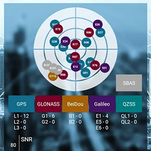
Using the SXblue ToolBox, receiver users can view and analyze the position data provided by the SXblue receiver and metadata related to its location. The user can send commands that enable or disable some features, including systems in use, mask angle or differential angle, and constellation in use, including GPS, GLONASS, Galileo, BeiDou and SBAS.
The SXblue ToolBox is also an NTRIP client capable of connecting to a NTRIP server for real-time kinematic (RTK) corrections and thus allow the receiver to issue very accurate location information. The application is able to record, save and transfer the raw data from the GNSS receiver, allowing post-processing activities on computers for surveying and geomatics professionals.
The application has been developed with special consideration for modern mobile device development and attention to user and dealer feedback, the company said.
The application includes a series of audible and visual alarms configurable by the user to determine the thresholds of the information provided by the SXblue GNSS receiver.
Main features of the SXblue ToolBox include:
Display of location information and quality of the position data
Skyplot of all-in-view constellations: GPS, GLONASS, Galileo, BeiDou, QZSS, SBAS
Log raw data
NTRIP/DIP client for receiving RTK corrections
Terminal to send commands and view the output data of the SXblue device
Audible and visual alarms
Activation of options and licenses via the application.
Avenza Maps 3.4 for iOS and Android is now available. It contains new features and performance improvements, including the ability to add and manage new symbols to aid users in customizing their Avenza Maps experience with a built-in collection of U.S. National Park Service recreational symbols.
Release highlights include enhanced support for point symbology. Also, users can package their own PNG symbols as (KMZ) files, import and use them in the app.
Add and manage symbols. Avenza Maps Pro users can import and manage readily available collections of industry specific sets of symbols. such as the EMSINA Australasian All Hazards Symbology Set and the U.S. National Wildfire Coordinating Group GIS Standard Operating Procedures (GSTOP) Incidents Point Symbols. These symbol sets can be downloaded directly from the Avenza Support Centre.
Add placemark workflow improvements. Improved add placemark workflow and screen to accommodate symbol selection and make it easier to add photos. The Add Placemark screen now appears every time the Add Placemark icon is tapped from the map view screen.
This allows the user to conveniently change the symbol (or use the default one) as well as add any necessary information such as photos or collect data in a schema. Several of the most recently used symbols are listed for quick selection. A default symbol can still be set for the layer so one symbol can always be chosen.
Target is installing app-based indoor mapping in its stores, making it easier for customers to find what they’re looking for.
Following a 2015 test, the U.S. retail chain is integrating beacon and Bluetooth technology with its mobile app. The app will show the shopper’s location in real time as they move about the store (with a familiar blue dot), and display nearby sales and deals.
Shoppers will also be able to find an item on the map through their digital shopping list.
Target describes the new technology as “a GPS for your shopping cart.”
“Just click on an item from your list and the app will indicate on a store map the precise aisle where you can find your item,” said Target chief information and digital officer Mike McNamara.
The beacons are a function of new, energy-efficient LED lighting that Target is installing in its stores.
Another mobile enhancement is Target’s integration of its savings app Cartwheel within its main store app. (Cartwheel is more popular than the primary Target app.) Target will use the beacon technology to highlight which of its Cartwheel deals are near a shopper’s current location. In the months to come, the app will support mobile payments at checkout.
The new indoor location technology will be live in across half of the chain of 1,800 stores in time for the 2017 holiday season.
Census data tries to describe for us what the homeless population looks like across the country. Typically the numbers contained in this data are considered to be low, as not all homeless individuals and families are “visible” so getting an accurate count can be challenging.
An interesting interactive map has been created by Movoto that allows the user to look at the number of homeless per 100,000 people in each state. But Geographic Information Systems (GIS), community involvement, and app builders are helping gather and utilize data to truly make a difference.
MOVOTO offers an interactive map.
It’s not surprising to note that most of homeless shelter users have goals, both short and long term. Kelly A. Schwend , Maureen Cluskey , and Michael Cordell of Bradley University explored these in a study released early this year titled “Lifestyles and Goals of Male Homeless Shelter Users.” While most participants short term goals are focused on employment, almost all of them had medium to long term goals involving housing.
The questions raised are several. How do we move the homeless from the streets into some kind of housing ladder, and who will assist them? GIS is helping to answer these questions in some of the larger population centers around the country. These programs are merely examples of what can be done elsewhere on a larger or smaller scale.
San Francisco
Over 10 years ago, then mayor of San Francisco Garvin Newsom promised that the worst of the homeless problem in one of the richest cities in the world would be gone. Ten years later, the city has moved nearly 20,000 homeless of the streets, but this hasn’t made a dent in the population. It seems that when one individual is helped, another takes their place.
Photo Credit: CartoDB
San Francisco Open Data contains information on the homeless population, counted by supervisory district. Taking this data, Bill Levay then overlays a San Francisco neighborhood shapefile. This not only shows where the homeless populations are concentrated, but by also adding in mapped locations of public and affordable housing locations, reveals if the resources are located near those in need. You can view the interactive map above here.)
Photo Credit: CantoDB
For instance, we can see on the map showing the intersection of this data that while a large portion of the homeless population is located near downtown and the South of Market area where there are only a few scattered public housing locations, there is much more public housing clustered together in Chinatown. While this issue has yet to be corrected, this information can be used to inform future decisions when locating resources.
Los Angeles
San Francisco is not the only populous city dealing with homelessness. Los Angeles is dealing with one of the largest homeless populations in the nation. A biennial survey taken in January, said to be the most rigorous and accurate so far according to City Labs, reveals 44,359 people sleeping on the streets, in their cars, and in shelters.
A Los Angeles Survey shows an estimated a homeless population of 44,359, a 12% increase since 2013. (Credit: Los Angeles Times)
A map created by the Los Angeles Times shows where this population ends up at night. Efforts are spotty at best, although the County’s Housing for Health program wants to have 10,000 permanent housing units created by 2018. Although Mayor Eric Garcetti says ending homelessness is a primary goal, and calls for funding for affordable housing, the problem continues to grow.
It is hoped that mapping the concentration of the population to help resource teams know what locations to target, the revision of laws prohibiting sleeping in public, and discouraging police raids on homeless encampments will help.
Baltimore
Baltimore’s homeless population is smaller than that of Los Angeles, but still significant. The city is using both mapping and a survey taken every two years to locate the homeless and target resources.
They’ve added another weapon to their arsenal, the Homeless Management Information System, (HMIS) spearheaded by the group The Journey Home and the Mayor’s Office for Health. Using this data, and a new web survey form, the city has obtained a more accurate picture of the homeless population, its location, and the resources still needed.
The survey, called the Point in Time (PIT), this year counted 2,796 homeless, 88% of whom were housed in shelters. The survey also looked at Housing Information Count (HIC). The study showed some progress and some setbacks, and revealed growth in the category of unaccompanied youth.
Photo Credit: Esri.com
The map above shows the population, and the location of resources all within a one and a half mile radius. The program not only uses mapping, but employs other technology to attempt to create long term, sustainable, and creative solutions to the city’s homeless issues.
New York City
Perhaps the most innovative mapping program in the country involves several apps being used in New York City. Launched in early August the new app called NYC Map the Homeless lets users take a picture of the homeless which is tied to their location, and use hashtags like #man or #sleeping to categorize individuals. They can even choose #violent to let authorities know about individuals perceived to be dangerous.
Photo Credit: NYC Map the Homeless
The idea, according to the developer, is to “gather as much data as possible to make sense of the homeless issues we’re seeing.”
He’s far from the first to try to use technology to address the increasing homeless issues in New York City, Homeless Helper, Feed it Forward, and WeShelter. WeShelter, provides direct assistance to the homeless, and wants create a behavior change from doing nothing to doing something, even if the user is not sure what to do.
The app lets users donate money to the homeless at the tap of a button, and also send location information to WeShelter, which helps them send outreach teams to areas with the most need.
Unlike Map the Homeless, WeShelter does not allow users to take pictures in the interest of privacy. it also keeps the location data it gathers closer to the vest, only making it available to homeless outreach groups.
Regardless of the location or the methodology, it is clear that mapping the locations of the homeless population and the resources available to them is a step in the right direction. GIS plays a large role in aiding social action.
Want to be a part of the solution? The Journey Home has some answers, but you can also get involved in your own community using the skills you have to aid in the eradication of homelessness. As WeShelter states, it’s all about a change in behavior from doing nothing to doing something.
Two new products from GPSTrackIt.com offer users of their Fleet Manager vehicle tracking, fleet and workforce management system new tools for navigating, routing and communication.
Field Service Manager provides access to Fleet Manager’s route planning and navigation system. New stops can be pushed out to the tablets from dispatch. It enables drivers to add stops to their route on the fly. Push notifications also alert the driver to incoming messages, regardless of which page in the app they are currently viewing.
GPSTrackIt Forms takes the communications component of the FSM to a new level. This tool provides the ability to quickly create forms to capture everything from text to photographs to signatures.
“The new forms tool is really powerful,” said Eddie Bermudez, GPSTrackIt.com’s product development manager. “Part of it’s power is the ease of use. The different field types are created by clicking a button and adding a field label. It’s that easy.”
GPSTrackIt Forms provides unlimited forms. Form data can be captured offline and updated later. The tool provides 24 preset field types, including text, video and a document viewer.
“The forms aren’t just dumb collectors, either,” added Bermudez. “There’s a rules engine that facilitates skip logic and branching. And the forms can have embedded formulas and perform advanced calculations, including formula-based form scoring.”
The form tool can also export data to Excel, PDF, CSV, and JSON formats. “These two tools combined provide drivers and the back office with an amazing array of opportunities to collect data about their customers, as well as their own customer service,” Bermudez said.
XRS Corporation, a subsidiary of Omnitracs LLC and provider of mobile trucking intelligence solutions, has announced integrations with Innovative IES and Appian DirectRoute transportation management software, both from TMW.
The newly integrated solutions are in addition to existing XRS integrations with TruckMate and TMWSuite software, also from TMW, and deliver enhanced operational visibility to fleets using both XRS and TMW platforms.
The integrated XRS solutions with TMW offer tangible benefits to drivers and to back-office personnel. Fleet managers can access vehicle and driver-specific data sourced from the XRS mobile fleet management solution directly through their TMW applications.
The streamlined information delivery saves time and eliminates the need to flip from one screen to another to access data from different systems. Furthermore, the availability of driver hours of service data from the XRS electronic logging device application within the TMS itself can help fleets improve driver and tractor use, as well as ensure they are HOS-compliant.
Also, drivers can now view routing and other driver-specific information from TMW software on their mobile devices. This simplified information delivery can streamline back-office to driver communication, reduce the likelihood of error, and lead to improved driver satisfaction and enhanced customer service.
“We continue to expand our stable of integrations, so that we are able to work with all major TMS solutions in the market. Our driver-centric integration with TMW solutions delivers significant value to our shared customers. Working with our industry partners, we’re continuing to make accurate data, including critical dispatch and routing information, easily accessible and even easier to share,” said Jon Van Winkle, vice president of product management for XRS. “These integrations allow drivers to focus on driving, without being bogged down by the cumbersome — and error-prone — task of manually entering data, while ensuring dispatchers have real-time updates to keep customers happy.”
“We have a long-standing relationship with XRS and these new integrations round out the suite of combined solutions available to meet and exceed the expectations of our shared customers,” stated Brian Larwig, VP and general manager, Appian, for TMW Systems. “The integration of the XRS Trip Management application with our Appian routing and tracking solutions makes possible the automatic route import and real-time trip activity updates from XRS Mobile, to deliver added value to the fleets we serve.”
The XRS platform, which runs on certified smartphones, tablets and rugged handhelds, provides drivers with a familiar interface for day-to-day operations and compliance. There are no additional, up-front hardware costs when the certified mobile devices are already in use, allowing fleets to immediately adopt the technology.