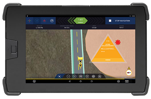
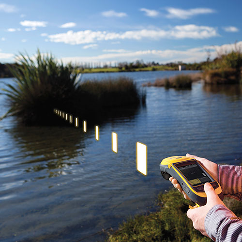
The Trimble GuidEx machine guidance system is an advanced navigation solution to guide machines along route corridors or to specific target areas.
Photo: Trimble
Trimble has introduced the Trimble GuidEx Machine Guidance System, an advanced machine navigation solution intended to quickly and efficiently guide machines along route corridors or to specific target areas, while providing local awareness using customer-provided mapping or engineering data to create exclusion and inclusion zones.
Trimble GuidEx uses an integrated GNSS and inertial navigation system (INS) to compute a virtual reference point and precise heading, pitch and roll.
Users can install the Trimble GuidEx system on anything from utility terrain vehicles (UTVs) to heavy equipment, on- or off-road.
Trimble GuidEx provides streamlined design-stakeout navigation that eliminates the need for advance survey stakeout operations. This enables machine operators to navigate to an exact point without stakes or surveyors, such as for core-sampling operations.
Corridor navigation allows users to efficiently complete a range of tasks including clearing paths for access routes and plowing snow. With comprehensive local machine data-logging, contractors can capture a range of data including position, time and speed.
“Trimble GuidEx was built to meet the needs of natural resource exploration activities, but can be used for many other applications,” said Scott Crozier, vice president of Trimble Civil Construction. “This system improves productivity and awareness with easy, efficient, task-specific navigation.”
To ensure work is done exactly where it should be, proximity and zone breach alarms can be set based on custom exclusion and inclusion zones.
Regardless of the equipment or the application, Trimble GuidEx uses customer-provided data to keep operators aware of prohibited or dangerous areas and decrease time and money wasted on unnecessary work.
Trimble GuidEx provides crossline navigation along predefined routes via an integrated software-based lightbar viewed on the display, including visual and audible alarms when operators breach user-defined distances from a centerline. The system also provides point and pad navigation information with intuitive navigational arrows, supported by a wide variety of data recording settings.
Compatible with virtually any machine type, Trimble GuidEx connects equipment to the office to keep everyone aligned. Operators and supervisors can send mapping data to and from the machine and office to avoid rework.
Reliable guidance data allows contractors to track machines by time or user-defined event triggers for a more accurate representation of the machine utilization cost of a project. Trimble GuidEx can leverage real-time kinematic (RTK) and CenterPoint RTX correction services for enhanced high-accuracy positioning.
TerraGo is partnering with CompassTools, a provider of integrated GIS, GPS and wireless solutions for field data collection across numerous industries, including government, utility, natural resources, transportation, architecture and construction.
“We help our customers build the best bundled solution for their GIS and GPS goals, whatever they may be, and TerraGo’s mobile solutions give us the flexibility we need for the wide spectrum of accuracy, workflow and data collection requirements,” said Andrew Carey, manager of Geospatial Solutions at CompassTools. “TerraGo provides out-of-the-box integration for all the leading platforms, while enabling customizable precision, basemaps, forms and workflows, which fits well with our customer-focused approach.”
“CompassTools helps organizations identify and implement the best combination of GPS receivers, hardware and software to meet their unique requirements,” said John Timar, vice president, Worldwide Sales, TerraGo. “TerraGo Edge and TerraGo Magic were designed from the ground up to support that type of customization; which makes it easy for customers to get the benefit of CompassTools’ expertise to help them deploy a solution tailored to their mission.”
TerraGo is hosting a webinar on Tuesday, Feb. 14, at 12 p.m. ET with a live demonstration of mobile GIS and GPS solutions available from TerraGo and CompassTools.
Global Tracking Project Demystifies the Ocean’s Top Predators
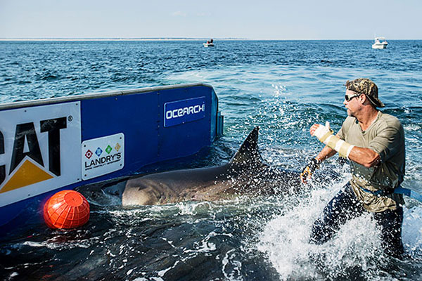
Chris Fischer helps tag Katharine, a 14-foot 2-inch, 2,300-pound great white, on Sept. 17, 2012. Katherine cruises the East Coast of the United States. (Photo: OCEARCH)
By Tracy Cozzens Photos courtesy of OCEARCH / R. Snow
Where are sharks? What are their migratory patterns? And how close do they come to shore? Until recently, the life cycle of sharks has been a mystery. The nonprofit OCEARCH is tagging and tracking a variety of sharks, and sharing the data with scientists around the world.
OCEARCH’s Global Shark Tracker app.
Since 2007, OCEARCH has tagged a total of 200 sharks, including 80 great whites, 80 tiger sharks and a few smaller species. About 50 tags are actively sending data to a publicly available shark tracker, also accessible with an iOS and Android app. OCEARCH also has popular Twitter feeds and Facebook pages for its most famous sharks, and Mary Lee (@MaryLeeShark, 86,100 followers) and Katherine (@Shark_Katharine, 32,300 followers). The access has changed the conversation from fear of a shark interaction to curiosity about their movements and life cycles, explained OCEARCH Founder Chris Fischer.
Before the shark tracking project, “We lacked the critical data on our large apex predators’ life history. We didn’t understand where they were mating, where they were giving birth, and these large complicated migrations that they make,” Fischer said.
Pulling a great white shark from the water long enough to tag it was a daunting hurdle that OCEARCH overcame by bringing together professional mariners, ocean experts and the academic community to solve the problem. The answer is a hydraulic lift system designed for shark tagging installed on the M/V OCEARCH research vessel. Once a shark is on the line, it’s maneuvered into a custom hydrauic lift. The 75,000-pound-capacity platform is designed to safely lift mature sharks for access by a multi-disciplined research team, who rush to conduct about 12 studies within 15 minutes before setting the shark free. The shark is guided by hand in the water on and off the lift.
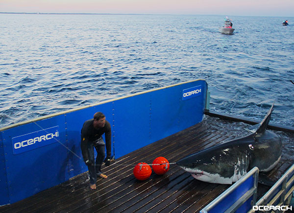
This hydraulic lift allows scientists to pull in and tag a live mature shark, in this case Mary Lee.
Once OCEARCH figured out how to capture and tag the sharks, the organization invited multiple institutions to share the data. “We decided to open source the data and give the tracking data away so that the world could track the sharks and be involved in the project at the same time as the Ph.D.s. And that’s where the Global Shark Tracker really came about: it was including the world in solving this puzzle in real time in this journey.”
The M/V OCEARCH now travels around the globe “to help the scientists who study our ocean’s giants explode their knowledge forward as fast as we can,” Fischer said. “So we have the critical data we need to keep these balance-keepers, these lions of the ocean, our large sharks with a bright future.”
Research expeditions are conducted worldwide aboard the M/V OCEARCH, which serves as both a mothership and at-sea laboratory.
The long-term goal is gaining a clear picture of the sharks’ needs, so that the oceans can be properly managed. “They’re the fundamental building block of the future of the ocean. If we don’t understand our apex predators, the top of the food chain, if we don’t understand how to manage them toward abundance, then we can’t manage the whole system toward abundance,” Fischer said.
More than 50 of the world’s leading institutions and more than 80 ocean scientists are involved collaborating and sharing data, a different paradigm from the classic way researchers work. “We realized quickly the old institutional way of researchers holding their data close to the vest and not sharing it with the world, trying to get ahead of one another to get papers published, wasn’t really effective for creating a movement and awareness around the future of the ocean at scale,” Fischer said.
Great White shark Katherine spotted by plane before being captured and tagged.
Information on where and when sharks swim and migrate can be leveraged for public safety, Fischer said. “Once we solve the puzzle of the migrations, the sharks then repeat the migrations to the same areas at the same times of the year. It allows people to get the rhythm of their lives and understand when they’re passing through their areas, and when they’re there and when they’re not.”
The sharks are tagged accelerometers, and with SPOT trackers from Wildlife Computers (short for Smart Position and Temperature Tag). Data from the accelerometers show that the animals regularly recover and start swimming strongly within 2–4 hours after release. Data from the Global Shark Tracker provides strong evidence that the animals tagged show long-term survival and long-distance migrations indicative of normal function and reproductive cycles, according to OCEARCH.
A SPOT tracker (top) and an accelerometer are attached to Mary Lee’s dorsal fin.
SPOT tags are designed to function in salt water. The tag is mounted on a shark’s dorsal fin and provides location data when a shark’s fin breaks the surface for at least 90 seconds. The five-year battery life of the trackers has helped scientists decipher the sharks’ three-year migratory loops. After that time, the sharks tend to shed the trackers. “We just borrow that access for five years, to solve the puzzle and collect the data,” Fischer said.
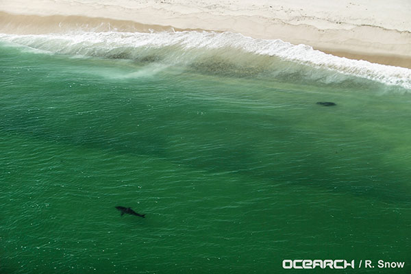
The data from OCEARCH has revealed that sharks come right to shore, into the breakwater, more often than most people thought. Also, their range is much bigger than expected, with some juvenile sharks discovered migrating all the way from Cape Cod to New Orleans.
Drifting tabular icebergs viewed from the Amundsen. (Photo courtesy of Greg McCullough, University of Manitoba)
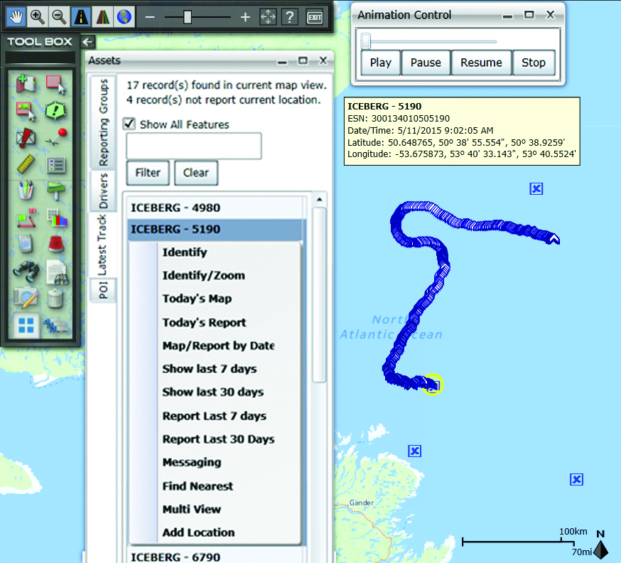
A Canadian expedition team used GeoDecisions’ GeoILS platform to help track icebergs during a voyage to better understand how icebergs drift. An intelligent location server using the Esri ArcGIS platform, GeoILS enables users to monitor and locate assets and facilitate quick and coordinated responses.
GeoDecisions, an information technology company specializing in geospatial solutions, partnered with Solara Remote Data Delivery Incorporated, Canada’s Carleton University and Esri during the project.
The FT2000IB Solara tracker. (Photo by Tom Tessier)
Led by University of Manitoba Scientist David Barber, the crew of Canadian Coast Guard icebreaker Amundsen sailed off the coast of Newfoundland and Labrador to research ice hazard mitigation, the effects of climate change, and polar region technology requirements. GeoILS location intelligence helped crew members visualize, analyze, and leverage project-pertinent data.
“During the expedition, researchers and scientists used GeoILS to assess drifting through sensor monitors attached to the icebergs,” said Brian Smith, vice president of commercial solutions with GeoDecisions. “In addition to reporting and notifications, GeoILS provided the project team with maps that were tailored by selecting desired iceberg information and the geographic area of interest based on user-defined criteria.”
GeoDecisions’ data portal was used with Iridium Solara tracking devices during the iceberg research project. Two icebergs were outfitted with FT2000IB Solara trackers, explained Derek Mueller, assistant professor and physical geography program supervisor with Carleton University.
THE GROUND control point and beacon. (Photo by Derek Mueller)
For each iceberg, two beacons were attached for redundancy and to determine the iceberg’s rotation. Holes were drilled and stakes inserted, then GeoDecisions Platform Tracks Icebergs the trackers attached to the stakes.
The trackers were also used as ground control points for photogrammetry, specifically the structure from motion ranging imaging technique.
“GeoILS and the satellite tracking beacons worked very well during this project,” Mueller said. “Thanks to our partners’ efforts, we now have a great new suite of tools for examining our data.”
“We are excited to provide tools to scientists who are gaining critical insights into the behavior of icebergs and global climate change,” said Tom Tessier, president of Solara Remote Data Delivery Incorporated.
The last tracker stopped transmitting on June 13. “The others ended earlier, likely because the iceberg rolled or broke up,” Mueller said.
Eos Positioning Systems has introduced a new line of high-accuracy GNSS receivers for smartphones and tablet computers, including both sub-meter and RTK performance for all mobile platforms: iOS, Android, and Windows.
Eos’s entry-level product, the Arrow Lite, is Bluetooth compatible with all mobile devices.
The Arrow 100 is Eos’s advanced real-time, sub-meter GNSS receiver that utilizes both GPS and GLONASS, and is expandable to Galileo, Beidou and QZSS. It offers superior tracking under tree canopy, around buildings and in rugged terrain, the company said. In addition to supporting SBAS in North/Central America, Europe, Northern Africa, Japan, India and Russia, the Arrow 100 also supports OmniSTAR’s worldwide, real-time sub-meter service.
The most advanced Arrow receiver is the Arrow 200, a dual-frequency, multi-constellation RTK GNSS receiver capable of 1-cm accuracy in real time. The Arrow 200 is an iOS-compatible RTK and OmniSTAR receiver that works with all models of iPads and iPhones via wireless Bluetooth connection. An iOS NTRIP app that allows the user to log into any available RTK network. The Arrow 200 will provide quality RTK performance for years to come because it supports current and future satellite constellations: GPS, GLONASS, Galileo, BeiDou and QZSS, the company said. It also supports OmniSTAR’s G2, XP and HP real-time worldwide decimeter services.
“After spending more than 12 years designing high-accuracy Bluetooth GNSS receivers, I believe Eos has set the new standard for high- accuracy GNSS receivers that work across all mobile platforms, no matter if it’s iOS, Android or Windows,” said Chief Technology Officer Jean-Yves Lauture.
All Arrow receivers employ long-range (1-km) universal Bluetooth connectivity so the user can interface to any brand of smartphone or tablet, whether it’s iOS, Android, or Windows-based. A variable-power Bluetooth implementation allows the Arrow receivers to communicate up to one kilometer from the mobile device.
Arrow receivers have been optimized to run all day on battery power. The battery pack is field-replaceable and rechargeable separately. It contains smart charging logic so expensive battery chargers are not needed.
All Arrow receivers have been designed to meet IP-67 specifications for immersion in water and are completely dust-proof so they will survive in the harshest environments.
The Arrow receiver product line is targeted at high-accuracy applications like GIS, environmental, agriculture, electric/gas/water utilities, surveying, machine control, and federal/state/local government.
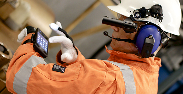
Bartec Pixavihas launched the “Impact X intrinsically safe smartphone” based on u-blox’ rugged 3G cellular module technology designed for devices used in tough industrial and outdoor environments. Bartec Pixavi is a manufacturer of mobile devices used in hazardous or explosive environments such as oil platforms, mines and chemical plants.
“Our Impact X smartphone is designed with the most robust, reliable and safe components available to ensure security and provide reliable connectivity to workers in potentially dangerous locations,” said Christian Rokseth, CEO of Bartec Pixavi. “We chose u-blox’ cellular module technology because of its industry-leading performance, excellent environmental tolerance and reliability.”
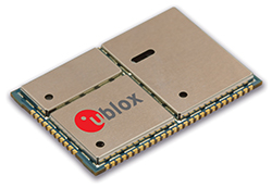
u-blox LISA u230 module. Photo: u-blox
The Impact X is CSA Class 1, Zone 1, IECEx and ATEX Zone 1 certified, explosion proof, waterproof and extremely ruggedized. At the heart of the Impact X is u-blox’ professional-grade LISA-U230 six-band 3G cellular module with 2G fallback capability. LISA modules also provide fully integrated access to u-blox GNSS receivers to enable advanced location-aware applications. Antenna diversity permits LISA-U2 modules to provide the highest data speeds.
“The Impact X is an excellent example of a high-performance mobile device that demands performance well beyond what is provided by standard mobile phones,” said Armin Boeshenz, General Manager of u‑blox sales EMEA. “We are extremely pleased to be a key module supplier to demanding customers such as Bartec Pixavi as proof of our industry-leading quality and reliability.”
u-blox LISA-U2 modules are suited for networks worldwide. Features include data-rates of up to 21.1 Mb/s (downlink), a rich set of Internet protocols, very small footprint, very low power consumption and extended operating temperature range of -40 to +85 degrees C.
The GPS Reflections Group of University of Colorado-Boulder has been awarded the prestigious Prince Sultan Bin Abdulaziz International Creativity Prize for Water. The prize is awarded biannually to acknowledge innovative work that contributes to the sustainable availability of water and the alleviation of the global problem of water scarcity.
The awards will be presented in a ceremony in Riyadh, Saudi Arabia, on December 16, concurrently with the 6th International Conference on Water Resources and Arid Environments (ICWRAE 6), December 16-18, 2014.
Professors Kristine Larson and Eric Small developed a new method to measure water at the Earth’s surface. The research team discovered that standard geodetic GPS instruments are sensitive to hydrological influences. They subsequently developed a cost-effective technique, GPS Interferometric Reflectometry (GPS-IR), to measure soil moisture, snow depth, and vegetation water content around GPS antennas. GPS-IR has the advantage of relying on an existing GPS infrastructure installed by surveyors and geoscientists that covers an increasingly large portion of the global surface.
Larson and Small collaborated with scientists at the University Corporation for Atmospheric Research and the National Atmospheric and Oceanic Administration, also in Boulder.
The team uses the GPS-IR technique to analyze data streams from existing GPS networks in near real-time. Data from hundreds of operational GPS sites are downloaded and processed, yielding estimates of hydrologic variables within 24 hours.
Scientists and government agencies can access this information at the team’s web portal and use the data to improve monitoring and forecasting of hydrologic variables.
The Trimble Geo 7 series of rugged, high-accuracy GNSS handhelds will have RTX correction. Photo: Trimble
Trimble’s RTX technology-based correction services — Trimble CenterPoint RTX, Trimble RangePoint RTX, and the new Trimble ViewPoint RTX — will be available for Trimble Geo 7X handhelds. Trimble made the announcement at Trimble Dimensions.
Trimble RTX technology provides compatible GNSS receivers with correction services that significantly improve accuracy and reliability in obtaining positions worldwide. Geospatial professionals now have more flexibility to achieve the accuracy required by their highly mobile workflows in real-time, without being tied to a base station or local VRS network, Trimble said.
Available worldwide through an IP connection where cellular communication is available, Trimble RTX offers geospatial professionals flexibility in where and when they are able to work. Operational efficiency and productivity in the field is improved by delivering real-time DGNSS corrections directly to the Trimble Geo 7X handheld. Field challenges, such as obstructed satellites and inaccessible locations, are also minimized with Trimble Floodlight and Trimble Flightwave technology options for the Trimble Geo 7X.
The handheld solution is designed for a variety of industries — such as utility companies, municipalities, and environmental management agencies — in which workers are highly mobile and require a reliable, flexible data-collection and asset management solution.
“We have eliminated the complexities of managing multiple correction sources across a large geographically dispersed project or organization,” said Alain Samaha, business area director of GIS and Software for Trimble’s Geospatial Division. “By offering RTX-based correction services, we simplify their work and deliver the accuracy that our customers require.”
A choice of RTX correction services ranging from 4 centimeters to submeter-level horizontal accuracies is available. Customers can choose the appropriate Geo 7X handheld configuration with the RTX-based correction service that meets the accuracy level and capability required for their job.
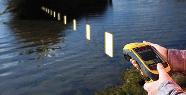
Rugged handheld manufacturer Juniper Systems and Effigis, a geomatics solutions provider, have partnered to provide a powerful solution to capture and post-process GPS data to attain sub-meter accuracy.
Effigis’ OnPOZ Precision Positioning Software suite takes advantage of the superior GNSS performance of Juniper Systems’ Archer 2 rugged handheld to collect high-accuracy GPS data. First, EZTag CE software is used on the Archer 2 to capture GPS field data points. The data is then sent to a desktop computer, where EZSurvPost-Processing Software automatically post-processes the data to achieve results with sub-meter accuracy. EZSurv removes the hassle of post-processing, requiring the click of a button to run, the companies said.
Juniper Systems’ Archer 2 is ruggedized, enabling it to perform well as a data-collection tool in any environment, while the enhanced GNSS receiver provides a reliable signal, even in heavy tree canopy.
“Achieving sub-meter GPS accuracy typically has two barriers in people’s minds. One, the hardware and software are usually expensive. And two, the thought of post-processing makes a lot of people cringe. The OnPOZ suite, on the other hand, is powerful, yet comes at a price people are comfortable with, and it takes care of all the post-processing for you,” said Jim Benson, Utilities & Public Services Market Manager at Juniper Systems. “The Archer 2 handheld really finishes off the whole package. Its GNSS receiver is outstanding, performing reliably even under trees, and the handheld is so well designed, you can count on it to work well in any environment.”
To learn more about the Archer 2 and OnPOZ Precision Positioning Software suite, download the brochure.
Handheld Group, a manufacturer of rugged mobile computers, has launched the Nautiz X8 rugged PDA. The Nautiz X8 is a handheld computer with superior processing power, screen performance and battery life, the company said. It is built for tough field conditions primarily in GIS, land surveying, public safety, forestry and the military.
Photo: Handheld Group
The Nautiz X8 is built to enable efficient and reliable data collection in tough environments. It has an IP67 ingress protection rating, which means it offers complete protection against dust and sand and can withstand immersion in water. It also meets stringent MIL-STD-810G military test standards for overall durability and resistance to humidity, shock, vibration, drops, salt and extreme temperatures.
The Nautiz X8 features a high-performance Texas Instruments 4470 dual-core 1.5 GHz processor. It has 1 GB of RAM, 4 GB of iNAND Flash and a 5200 mAh Li-ion battery that lasts up to 12 hours on a single charge. It comes with a choice of operating systems — Android 4.2.2 or Windows Embedded Handheld 6.5.3.
The device has a large 4.7-inch ultra-bright capacitive multi-touch screen with chemically strengthened Asahi Dragontrail glass, offering users brightness and protection in any field condition. The unit has an ergonomic design and weighs 490 grams (17.3 ounces).
The Nautiz X8 has a dedicated u-blox GPS receiver, Bluetooth 2.0 and 802.11b/g/n WLAN functionality, as well as connectivity through GSM/UMTS or CDMA phone data transmission. A built-in 8-megapixel camera with autofocus and an LED flash lets users capture visual data quickly and easily. This handheld also features an open architecture and an extension cap system that allows for additional hardware connections such as sensors, radios and other add-ons.
Orders for the new Nautiz X8 can be placed immediately. First deliveries will begin in November.
The Nautiz X8 rugged handheld will be shown first at WEFTEC in New Orleans, followed by InterGeo in Berlin.
Trimble has introduced an integrated GNSS reference receiver, broadband seismic recorder and a force-balance triaxial accelerometer for infrastructure and precise scientific applications.
The Trimble SG160-09 SeismoGeodetic system provides real-time GNSS positioning and seismic data for earthquake early warning and volcano monitoring as well as infrastructure monitoring for buildings, bridges, dams, as well as other natural and manmade structures.
The Trimble SG160-09 SeismoGeodetic system combines the innovation, reliability and data integrity of both the Trimble and REF TEK brands into a single instrument, Trimble said. The system integrates seismic recording with GNSS geodetic measurement in a single compact, ruggedized package. It includes a low-power, 220-channel GNSS receiver powered by the latest Trimble-precise Maxwell 6 technology and supports tracking of both GPS and GLONASS signals plus the Galileo E1 frequency.
The system includes both the SG160-09 and utilization of Trimble’s CenterPoint RTX correction service, which provides on-board GNSS point positioning. Based on Trimble RTX technology, the service utilizes satellite clock and orbit information delivered over cellular networks or Internet Protocol (IP), allowing cm-level position displacement tracking in real-time anywhere in the world. The SG160-09 system will be available for purchase without the RTX correction service for those applications using real-time kinematic (RTK) positioning.
The seismic recording sensor includes an ANSS Class A, low-noise, force-balance triaxial accelerometer with the latest, low-power, 24-bit A/D converter, which produces high-resolution seismic data. The internally built accelerometer has +/- 4g full scale output, large linear range, high resolution and sensitivity, which makes it ideal for both portable and permanent deployment. The SG160-09 processor acquires and packetizes both seismic and geodetic data and transmits it to system operators using an advanced, error-correction protocol with back-fill capability providing data integrity between the field and the processing center.
The SG160-09 system is ideal for earthquake early warning studies and other hazard mitigation applications, such as volcano monitoring, building, bridge and dam monitoring systems. The SG160-09 system features a variable size industrial grade USB drive to support real-time telemetry data transmission. In the event of a telemetry link outage, the data is stored on the USB drive and can be re-transmitted to the centralized processing station as soon as the communication link comes back up, allowing no data loss during the system operation.
The Trimble SG160-09 system is optimized for field use with instrument mounted or externally mounted GNSS antenna configurations. The lightweight yet rugged SG160-09 consumes very little power and can be used for projects with remote connectivity and in extreme weather conditions. Because the SG160-09 combines both GNSS and strong motion in a single instrument, site installation time is reduced, data communications flow through a single pathway, and station power infrastructure is streamlined, making the SG160-09 a cost competitive solution compared to other systems on the market today. It has an IP67 rating, which means it is sealed against dust and can be submerged in water up to a meter for approximately 30 minutes. The SG160-09 also meets MIL-STD 810F standard for drops, vibration and temperature extremes.
“The SG160-09 is another example of Trimble’s on-going focus in GNSS and seismic technology for the scientific and engineering communities,” said Ulrich Vollath, general manager for Trimble’s Infrastructure Division. “Trimble has developed a combined state-of-the-art GNSS receiver with a high-dynamic range, low-noise accelerometer that provides dynamic monitoring with the flexibility required for today and tomorrow’s challenges.”
The Trimble SG160-09 SeismoGeodetic system is expected to be available in the fourth quarter of 2014.
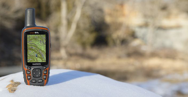
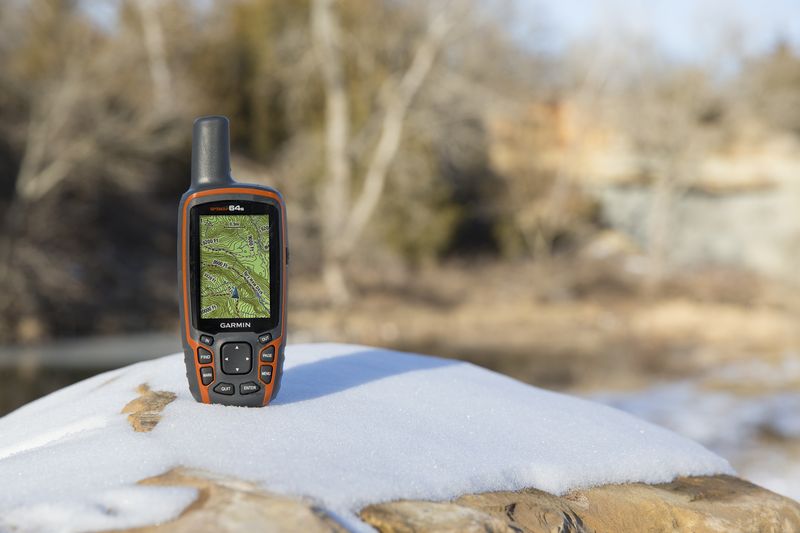
Garmin International Inc., a unit of Garmin Ltd., today announced the GPSMAP 64 series of rugged outdoor handhelds. The GPSMAP 64 series brings a dual GPS and GLONASS receiver, preloaded geocaches and smartphone connectivity for LiveTrack and Smart Notification to its product line for hikers, hunters, and geocachers.
“Building on the popularity of the GPSMAP series, the new GPSMAP 64 series improves functionality to make a top-notch device even better,” said Dan Bartel, Garmin vice president of worldwide sales. “The GPSMAP 64 is ideal for anyone, no matter if it’s their first handheld, or if they’ve used Garmin for years. It combines trusted Garmin technology with the comfort of a device people know and love.”
The GPSMAP 64 series has a 2.6-inch sunlight-readable transflective color display and a high-sensitivity GPS and GLONASS receiver with a quad helix antenna for superior reception. With the addition of GLONASS satellites, the time it takes for the receiver to lock on to a position is (on average) approximately 20 percent faster than using GPS alone. This allows users to get their position quickly and precisely even in heavy cover and deep canyon.
The GPSMAP 64 series features three distinct water-resistant (IPX7) models to suit various activities and interests. The basic GPSMAP 64 includes a built-in worldwide basemap with shaded relief, and supports BirdsEye Satellite imagery and TOPO U.S. 24K maps. The GPSMAP 64s adds a 3-axis electronic compass and barometric altimeter. Additionally, the 64s adds wireless connectivity for data transfer between other compatible Garmin handhelds and mobile apps, and for Smart Notification technology. With this, users can receive emails, texts and alerts on the device (when paired with an iPhone 4S and later). This allows users’ smartphones to be safely protected from the elements. The 64s also comes with a one-year subscription of BirdsEye Satellite Imagery. The GPSMAP 64st includes preloaded U.S. 100K topographic maps. With this, users will be able to search for points of interest by name or proximity to their location and view descriptive details for terrain contours, topo elevations, summits and geographical points.
For outdoor adventurers, the rugged GPSMAP 64 devices are compatible with BaseCamp, a free software download that allows users to view and organize maps, waypoints, routes and tracks. The 64s and 64st models are compatible with the BaseCamp mobile app for data transfer, and the Garmin Connect mobile app, for features such as LiveTrack. With LiveTrack, users can pair their device with the app, and invite friends and family to follow their activity in real time. This provides peace of mind, especially if users are alone. Through ANT+, the 64s and 64st models are also compatible with external sensors such as an external temperature sensor and heart rate monitor. With ANT+, the 64s and 64st models can act as a remote for the new VIRB and VIRB Elite action cameras.
Each device comes preloaded with the locations of 250,000 geocaches from Geocaching.com. Devices store and display key information to find the hidden containers including the geocache coordinates, terrain rating, its difficulty, hints and descriptions, so users no longer have to manually enter coordinates or print out geocache info. By going paperless, users are helping the environment, and improving their efficiency. If users would like to continue geocaching beyond the preloaded geocaches, when they register their device they can sign up for the free premium membership trial through Geocaching.com, and download more geocaches. The GPSMAP 64 devices can store millions more, so users will no longer have to pick and choose which geocaches they want to load on their device.
All of the devices in the GPSMAP 64 series have a dual-battery system, where both standard AA batteries and a rechargeable NiMH battery pack (sold separately) can be used. The devices have internal memory (4GB for 64/64s and 8GB for 64st), and a microSD card slot to store additional data and maps.
The new GPSMAP 64 series will be available this month. The GPSMAP 64 will retail for $299.99, the GPSMAP 64s will retail for $399.99, and the GPSMAP 64st will retail for $499.99.