Safran Electronics & Defense had unveiled Skydel NAVWAR, a software solution designed to protect against hostile UAVs by disrupting their navigation systems.
As the core of Safran’s counter-UAV (C-UAV) systems, Skydel NAVWAR disrupts UAV navigation by simulating authentic GNSS signals, providing nations and organizations with advanced protection for their most critical assets.
Skydel NAVWAR can be deployed on tactical platforms and integrated with sensors and command-and-control systems, allowing operators to conduct remote spoofing operations without being physically present at the target location.
“Protecting national sovereignty requires more than just technology — it demands trusted systems that empower countries to take control of their own security,” said Maxime Gorlier, director of positioning, navigation and timing at Safran Electronics & Defense. “With Skydel NAVWAR, we are giving our partners the capability to safeguard their airspace, defend critical infrastructure and ensure resilience in the face of evolving threats.”
The system features a secure application programming interface, hardened operating system and field-tested durability designed for demanding operational conditions. It supports all major global navigation satellite systems, including GPS, Galileo, GLONASS, BeiDou, NavIC, QZSS and space-based augmentation systems, as well as emerging low-Earth orbit (LEO) signals.
The software can simulate thousands of satellites in real time using commercial off-the-shelf hardware and operates at a 1,000 Hz iteration rate.
Safran designed the system to enable defense integrators to build sovereign anti-drone capabilities, enhancing national autonomy in countering UAV threats.
GNSS simulation has evolved well beyond accuracy testing. It now covers full-spectrum NavWar and PNT validation. Today’s simulators are expected to generate real-time GNSS, LEO signals, inertial measurement units (IMU), alternative navigation sources, jamming and spoofing — all from a single system.
“The number of signals continues to grow with the rise of multi-PNT sources and advanced threat capabilities,” said Jaemin Powell, senior product manager, NavWar & Simulation at Safran Federal Systems. “Our customers are preparing for GPS-denied operations, validating NavWar responses and ensuring resiliency in contested domains.”
Powell noted that Safran Federal developed BroadSim Genesis to enable simultaneous streaming of L1, L2, L5 and L6 GNSS and LEO signals with integrated jamming and spoofing — all within a compact 4U platform.
The company’s strategy is built on a software-defined architecture, allowing for rapid adoption to evolving threats and mission requirements, Powell said. Safran Federal collaborates closely with government stakeholders and defense primes to stay up-to-date with new requirements and incorporate real-world threat vectors, such as spoofing and jamming. The BroadSim platform supports software upgrades for every feature, from adding constellations and LEO signals to enabling hardware-in-the-loop (HIL) support or integrating additional PNT resources.
While defense and aerospace continue to serve as core markets, rising demand also is coming from space companies, LEO-PNT developers, and advanced electronic warfare laboratories now relying on Safran simulators.
“These users value the scalability, fidelity and flexibility of our simulation solutions, especially in environments with high dynamics,” Powell said. “They are looking beyond traditional GNSS, and we address that need with a simplified, all-in-one platform.
Large-Scale Simulation
“Large-scale simulation is technically demanding,” Powell added. “Generating thousands of signals across multiple bands with ultra-low latency and 1000 Hz update rates pushes both hardware and software boundaries.”
Maintaining the intuitive Skydel interface while adapting to evolving NavWar requirements remains a top priority for the company. For example, Safran Federal introduced real-time automated calibration for BroadSim Wavefront, which executes before every scenario. This allows users to power up and immediately begin testing, eliminating recalibration and setup delays.
“Simulation is more than just signal generation. It is about enabling operational confidence,” Powell said.
“Our platform gives users the ability to stress test systems, visualize behavior in real time and adapt quickly without relying on range time or live sky testing…We are enabling teams to meet their toughest NavWar and PNT challenges with confidence and flexibility. If you have demanding requirements, we are ready to deliver a solution that is intuitive, capable and built for the future.”
CACI International has been awarded a ten-year contract valued at up to $450 million to support the Joint Navigation Warfare Center (JNWC), an operational center of U.S. Space Forces and the Department of Defense’s (DOD) center of excellence for navigation warfare (NAVWAR).
Under this contract, CACI will provide 24/7 operations support, joint and operational planning, adversary positioning, navigation and timing (PNT) capability assessments and other tasks to enhance joint force, DOD combatant commander, interagency and allied NAVWAR requirements.
“Adversary PNT capabilities rapidly evolve, putting our warfighters and national security operations at risk around the world,” said John Mengucci, CACI president and CEO. “CACI’s experts comprehensively understand multi-domain PNT threats and advise combatant and joint force commanders on how to swiftly respond to NAVWAR threats and operational requirements.”
PNT is critical to U.S. national security and NAVWAR. This includes deliberate defensive and offensive actions to ensure and prevent PNT use through space, cyber and electronic warfare. The contract represents new work for CACI, with mission experts supporting global NAVWAR reach-back operations via the Joint NAVWAR Operations Center (JNOC). These experts will assist combatant commanders in operating in PNT-disrupted, denied and degraded areas by conducting operational field assessments, war gaming scenarios, modeling and simulating threats and more.
TRX Systems has added a jammer finder capability to its NEON PT-MIL. The new function and expanded threat-mapping features enable dismounted soldiers to proactively respond to navigational warfare attacks (NAVWAR).
NEON PT-MIL helps warfighters carry out their missions even when operating in environments where GPS/GNSS signals are unreliable or intentionally denied. The device can detect and eliminate compromised GNSS data while providing an alternative source of positioning information by fusing inputs from inertial sensors, GNSS signals, ultra-wideband and more.
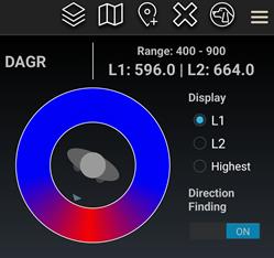
NEON PT-MIL can also be equipped to detect and map jamming and spoofing attacks. This feature was developed through a United States Army Rapid Capabilities and Critical Technologies Office program designed to extend NAVWAR functionality. The device accepts assured GNSS data from external devices — such as the Defense Advanced GPS Receiver, or DAGR, and the Orolia Defense and Security Broadsense Nano — to deliver a fused position and a NAVWAR threat indication when detected.
The device can also derive a line of bearing to an enemy jammer and display it within the warfighter’s Android Tactical Assault Kit (ATAK) user interface, by using the GPS jamming indications available from a connected GNSS source.
NEON PT-MIL with the jammer finding function is available in beta versions for field testing now and will be generally available in mid-2023.
What works well and what needs improvement in the GPS program regarding technology, policy, or management?
Jules McNeff
“GPS technology and operational performance continue to set the standard for GNSS, but necessary modernization is late to need, and becoming later by the day. This reflects what I see as loss of focus on ‘Job 1’ (delivering effective GPS service to the Joint Force) and a diminution in the sense of ‘GPS uniqueness and exceptionalism’ in its management as it was fragmented within the old SMC and is no longer the ‘shiny new object’ within the evolving Space Force. Even so, its value to its global user base, and particularly to U.S. and allied militaries, is stronger than ever and it remains the cornerstone among diverse complements within the Department of Defense PNT Enterprise. It is incumbent on the DOD to ensure the GPS services our warfighters will depend on can sustain that vital role.”
— Jules McNeff Overlook Systems Technologies
Ellen Hall
“What works well? There is good focus on the areas that need development: M-code, CRPA, resiliency. What needs improvement? More thorough and timely sharing of information by the government with industry.” — Ellen Hall, Spirent Federal Systems
Mitch Narins
“The ‘GPS program’ has set the standard for all other GNSS efforts, but there are always lessons to be learned. I have full confidence that USSF leadership is well equipped to deal with both the technology and management aspects of the program. As for policy, which supports military and civil uses worldwide, there is a clear distinction, based on mission areas and acceptable risk. However, risks to civil users have increased as GPS PNT services permeate all civil critical infrastructure systems. Therefore, system improvements directed at civil user PNT resilience should be given a higher priority and funded through appropriate civil channels. I encourage a policy to enable more resilient PNT services from space — and to consider that by looking both ‘up’ and ‘down’ for PNT services, unfortunate ‘situations’ might be avoided.” — Mitch Narins,
Strategic Synergies
Bernard Gruber
“One of the most consistent and enduring enablers of the GPS program is national policy. NSPD-39 re-baselined requirements buttressed by GPS being provided to the world for free, that it must be sustained and have an ever-present focus on performance improvement and robustness. Accordingly, NSPD-7 acknowledges an ever-changing world with a nod to cybersecurity, augmentations and direction to “improve NAVWAR capabilities to deny hostile use of United States Government space-based PNT services, without unduly disrupting civil and commercial access to civil PNT services.” — Bernard Gruber,
Northrop Grumman
APNT/Space modernization gives U.S. Army a clearer view of multi-domain battlefield
U.S. Army soldiers experiment with new assured PNTT/space equipment during the 2021 PNT Assessment Exercise at White Sands Missile Range, New Mexico. (Photo: U.S. Army/Austin Thomas, Army Futures Command)
News from U.S. Army Futures Command
The Assured Positioning, Navigation and Timing/Space Cross-Functional Team — APNT/Space CFT — takes a multi-dimensional approach to understanding and preparing for future warfare.
The team — based at Redstone Arsenal, Alabama — is dedicated to advancing the Army’s tactical and navigational capabilities and ensuring tomorrow’s soldiers have the modern situational tools they need to maneuver with the utmost accuracy, safety and skill.
The CFT is making significant progress toward this goal by leveraging iterative developments, remaining open to new technologies and committing to continuously evolving PNT equipment and systems to meet changing threats and needs.
“Our cross-functional team will continue to assess and strengthen the future of our operational environments, emerging threats and technologies to ensure our Army is prepared for 2030 and beyond. We will continue to support the requirement development and delivery of trusted solutions to the soldier,” said Michael C. Monteleone III, director of the APNT/Space CFT, reiterating the team’s focus on nimbly and steadfastly enabling the success of future warfighters.
According to Army planners, the likelihood of future operations spanning diverse domains — air, land, sea, space, cyberspace and the electromagnetic spectrum — means soldiers will need more flexible and far-ranging resources to inform their movements and operations.
To facilitate this, the APNT/Space CFT conducts rigorous field experimentation and prototype assessment and drafts detailed requirements for state-of-the-art materiel solutions, which the Army can then further develop and employ to improve information gathering and data precision without disrupting or adding extra burden to soldier operations.
Experimentation for APNT/Space happens on the ground and in the air, including along the electromagnetic spectrum — sometimes referred to as the “invisible battlefield” — and in the low Earth orbit of space.
Within these frequently interwoven domains, the APNT/Space CFT investigates alternative GPS capabilities and other navigation resources already in use, while also evaluating how to best integrate new anti-jamming functions, electronic support, inertial navigation systems and vision-based navigation platforms.
The CFT coordinates regularly with industry, joint partners and other government agencies to identify and explore solutions that are modular, scalable and an excellent fit for multiple platforms, as well as the upgrades and adjustments that occur to equipment and systems over time.
Modern PNT tools being developed and fielded include mounted, dismounted and alternative navigation systems, situational awareness devices, and next-generation sensors that allow for optimum flexibility and performance against threats.
Within the realm of space, the CFT is shaping a strategy to provide survivable, responsive and resilient intelligence, surveillance and reconnaissance and communications capabilities in low Earth orbit, complete with the ability to share information rapidly and securely with tactical commanders on the ground.
The team’s experts are also focused on understanding and preparing for the future of navigation warfare, or NAVWAR, which will require sophisticated offensive and defensive systems to produce tactical advantages and enable overmatch. To encourage synchronization of efforts on this front, the CFT is working closely with Army partners to draft an overarching NAVWAR strategy that aligns with U.S. Department of Defense NAVWAR plans but is also tailored to unique Army needs.
By studying and preparing for multi-domain operations and experimenting with the newest technologies available, the APNT/Space CFT is playing an integral role in helping the Army to equip soldiers with more mobile, scalable and interoperable navigation devices, in turn strengthening the agility of the future force.
DIU accelerates commercial GEOINT and NAVWAR tools and capabilities to the warfighter
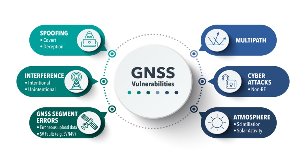
The U.S. Defense Innovation Unit (DIU) will be testing ways to mitigate disruptions to GNSS signals this fall.
Disruptions include those from intentional sources, such as spoofing, as well as intentional or unintentional jamming. Intentional tactics can be applied by adversarial nation states, criminal networks or privateers.
The shared interests between the government and private citizens alike for awareness of GPS disruptions make commercial solutions ideal; information and insight can be broadly shared not just within the U.S. Department of Defense (DOD), but across agencies, allied partners and the public as needed.
In the Fall of 2021, the DIU launched the Harmonious Rook prototype project to address the need for scalable, persistent awareness of positioning, navigation and timing (PNT) disruptions across the globe.
This September, the Harmonious Rook team will support the U.S. Army 1st Armored Division’s Command Post Exercise (CPX) at the National Training Center (NTC), Fort Irwin, California. The exercise is focused on large-scale combat operations (LSCO) and intended to stress the division headquarters’ ability to deploy to an austere location and command and control its units utilizing a synthetic training environment.
U.S. and multinational maritime forces participate in SEACAT 2021. (Photo: NTC)
Parallel to this training event is the 2nd Brigade, 1st Armored Division’s external validation exercise, also at NTC, in which the 2nd Brigade will be stressed and evaluated on its ability to deploy while contested and conduct LSCO exercises against a live opposing force.
Several DOD and civilian agencies are participating, including the National Air and Space Intelligence Center (NASIC) and the National Space Intelligence Center (NSIC). Multiple non-traditional vendors and non-governmental organizations are also supporting Harmonious Rook, from data delivery, to machine learning analytics, to visualization and contextualization.
Vendor Participation
Several Harmonious Rook vendors will participate in notable DOD and international exercises. In August 2022, prototyping companies will support the Southeast Asia Cooperation and Training (SEACAT) exercise, where more than 20 Indo-Pacific countries will train and collaborate on the common goal of maritime crises and illegal activities response.
During this multinational exercise, commercial firms will provide space-based geolocation reports and maritime analytical services, and integrate the insights into the U.S. Navy’s and Department of Transportation’s shared visualization platform, Seavision.
DIU is also working to explore the use of publicly available PNT data to draw insight from domestic GPS interference events.
“Mapping GPS disruptions and contextualizing patterns of behavior are key to mitigating the effects of degraded PNT as well as enabling safety of navigation under such conditions,” said Lt. Col. Nicholas Estep, Harmonious Rook program manager, USAF. “Instead of developing, building, and deploying hardware tailored for collection of navigation warfare operations, we are accessing currently available commercial data and analytics to address the need for PNT situational awareness. There are billions of GPS users and devices distributed across the world that may be adversely affected and turning the vulnerability into an advantage for discovery, classification and attribution of such malicious activity is a key aspect of this effort.”
“The Harmonious Rook project is a very promising new approach that complements traditional collection methodologies, as it will help our customers by sharing analysis due to the unclassified and commercial nature of the data,” said Scott Feairheller, senior analyst at NSIC.
“While the Army works diligently to acquire relevant equipment to assist in the real-time recognition and characterization of potential adversary interference, we must leverage non-organic, commercially available software and equipment, like Harmonious Rook, as a stopgap to increase awareness, seize digital key terrain and maximize lethality,” said Lt. Col. Patrick Jones of 1st Armored Division’s Space Support Element (SSE). During the exercise, capabilities will be tested to support intelligence, information operations, and command and control elements with commercial geospatial and navigation warfare awareness at the tactical level.
DIU’s Harmonious Rook program is not limited to the DOD and the malicious activity more commonly observed overseas and in combat environments. DIU is also working to explore the use of publicly available PNT data to draw insight from domestic GPS interference events, a mission with interest from the U.S. civil agencies.
With widespread users and subscribers that rely on PNT services, any intentional or unintentional disruption can lead to severe transportation, communication and financial implications. This highlights the importance of bringing both government and private-sector industries together to identify, attribute and mitigate GPS interference as quickly as possible.
In early August, the U.S. Government Accountability Office (GAO) released its third report in 15 months about GPS and other positioning, navigation and timing (PNT) issues within the Department of Defense (DOD). Each report raised raised concerns about the way in which PNT programs were being managed and led within the department.
Observations included that DOD continues to rely heavily on GPS despite known vulnerabilities. Also, that alternate PNT efforts are not well coordinated and receive little support.
“Opportunities” for DOD to improve its alternate PNT efforts, according to the report, include:
Improving coordination across the services
Clarifying authorities and responsibilities for prioritizing needs
Focusing on resiliency versus GPS as the cornerstone of department PNT efforts
Clarifying PNT requirements rather than just defaulting to GPS as “the need”
The report pointed out that M-code has been in development for 20+ years, and that GPS satellites have been capable of transmitting M-code signals since 2005. Also, while there are still program risks, the Next Generation Ground Control Segment, known as OCX, is forecast to be ready to support M-code use by 2023.
OCX has experienced severe cost overruns and is more than five years behind its original schedule. GAO issued a report on OCX delays in May 2019.
M-code won’t really be a capability in DOD, though, until user equipment is widely fielded. That will take several more years, according to GAO.
One of the remaining challenges to M-code implementation, GAO said, was that the department did not collect and validate all the data it needed for leadership planning and prioritization.
A summary on the first page of the report contains what could be seen as harsh criticism of how PNT efforts are led within DOD:
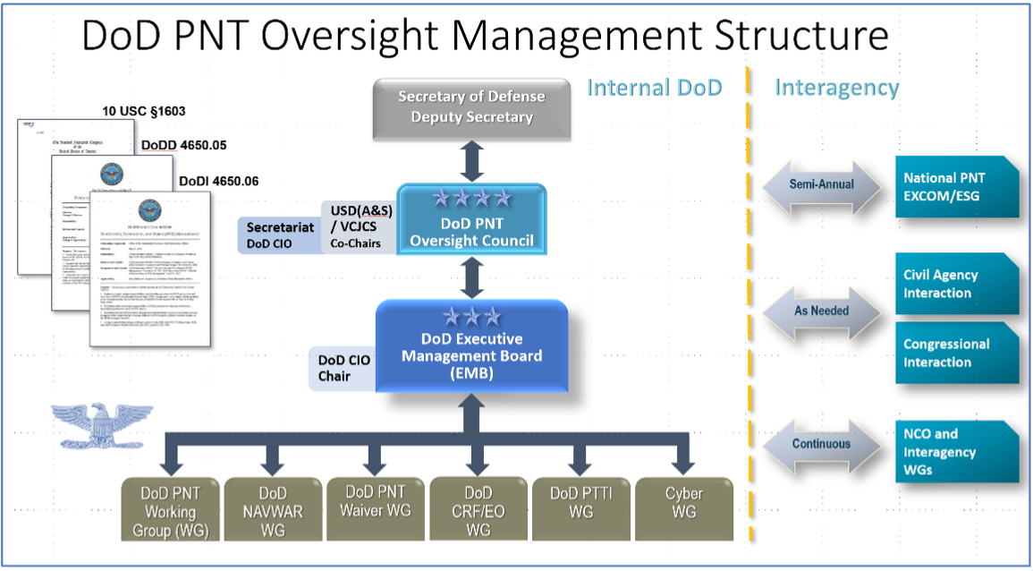
“DOD’s overall PNT portfolio is managed by the PNT Oversight Council, a statutorily established senior-level body. However, the Council has largely prioritized modernizing the existing GPS system over alternative PNT efforts during recent meetings and has no strategic objectives or metrics to measure progress on the alternative efforts.”
Image: DOD
Too Much Leadership?
Some believe the real problem with DOD PNT is not a lack of leadership, but rather too much.
“If everyone is in charge, no one is,” commented one retired senior military officer familiar with the issue.
“Congress has been concerned about DOD’s lack of attention to GPS and PNT alternatives for years,” the individual said. “In 2015 Congress mandated creation of the Oversight Council to help ensure PNT got the right amount of leadership attention.” This may have not had the desired effect, though.
“The council is comprised of three undersecretaries, the vice chairman [of the Joint Chiefs of Staff], four combatant commanders, the NSA [National Security Agency] director, DOD’s CIO [chief information officer], and host of other very senior folks. All of whom have way too many other duties. It’s no wonder the department has a hard time getting things done!”
The department’s CIO is the Defense Secretary’s Principal Staff Assistant for PNT. As such, the CIO is tasked with coordinating department-wide efforts. The task is made particularly difficult by the many and diverse players across the department, all of whom have their own authorities, interests and projects.
Proposed systems and capabilities are examined and developed by a variety of DOD organizations. These include laboratories belonging to the five services and the Defense Advanced Research Projects Agency (DARPA).
Programs of Record, which usually lead to acquisition of large systems, are led and managed within the individual services.
A Better Way?
Aside from recommending improved coordination of PNT efforts across the department, GAO has never addressed the way DOD manages its PNT enterprise.
“That is not something we normally get into unless specifically tasked,” said one of the reports’ authors. “We assume departments know best how to lead and manage their efforts.”
Others are not so reticent. They believe the current management structure is incapable of managing the development, acquisition and fielding of the DOD PNT Enterprise with any urgency or efficiency.
“GAO’s focus on the Oversight Council is misplaced,” one retired official asserted. “The missing piece is not oversight, it’s day-to-day DOD-wide management.”
“They need a multi-service program of record for resilient PNT,” the official said. “This would be separate from the GPS program, which would keep its own projects going and feed into the resilient effort. The new resilient PNT program should be managed by a Joint Program Office, which could consolidate integration and acquisition of resilient PNT applications. The office would be the steward for the critical technologies that underpin the modular, open-system integration strategy, including the digital reference architecture, input and output standards, software fusion engines, and needed modeling and simulation tools to ensure NAVWAR compliance.”
Such a construct could provide needed focus and coordination to DOD efforts, address many long-standing congressional concerns, and, by coordinating efforts within DOD and with industry, accelerate progress.
Dana A. Goward is President of the Resilient Navigation and Timing Foundation. He serves on the President’s National Space-based Positioning, Navigation, and Timing Advisory Board.
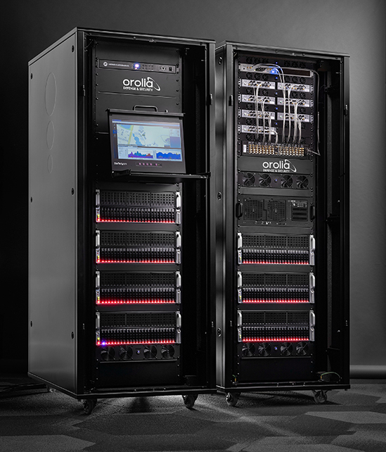
Orolia Defense & Security, provider of software-defined simulation solutions for navigation warfare, will supply a BroadSim Wavefront to the U.S. Air Force Guided Weapons Evaluation Facility (GWEF). BroadSim Wavefront is an innovative, Skydel-powered advanced GNSS simulator.
The BroadSim Wavefront simulator from Orolia Defense & Security. (Photo: Orolia)
The GWEF provides laboratory testing and simulation tools for developing precision-guided weapon technology, including a comprehensive scope of GPS plus inertial navigation systems (INS) and integrated components such as sensors, signals of opportunity and controlled reception pattern antennas (CRPAs). CRPAs are fundamental in many platforms due to their enhanced protection against electronic attacks in NAVWAR environments.
The Broadsim Wavefront simulator will be integrated into a test environment for networked, collaborative and autonomous weapon systems being developed under the Golden Horde program. Golden Horde is one of four Air Force Vanguard programs designed to rapidly advance emerging weapons systems and warfighting concepts through prototype and experimentation.
Of the several capabilities the GWEF required, features such as low-latency hardware-in-the-loop, automated calibration, and the flexibility to quickly integrate future signals and sensors were the most critical and serve as a key reason Orolia’s BroadSim Wavefront was selected. The system will also be capable of testing eight-element CRPA systems, eight simultaneous fixed radiation pattern antenna systems (FRPA), or a combination of CRPA and FRPA systems.
“When designing BroadSim Wavefront, we re-imagined every aspect for the user,” said Tyler Hohman, director of products for Orolia Defense & Security. “Though the GWEF unit contains eight nodes (corresponding to each antenna element), it can be scaled from four to 16 antenna elements. One of the greatest advancements is our continuous phase monitoring and compensation technique. It automatically monitors, aligns and adjusts the phase of each RF output continuously throughout the duration of a scenario.”
“Gone are the days of re-calibrating each frequency on your system, limiting your scenario duration or re-calibration every time you power cycle your system,” Hohman said. “Simply turn the system on, start the scenario, and your Wavefront system phase aligns and remains aligned for the entirety of the test.”
Leveraging the Skydel Simulation Engine, BroadSim Wavefront also supports high-dynamics, MNSA M-code, alternative RF navigation, open-source inertial measurement unit (IMU) plug-ins and a 1000-Hz iteration update rate.
“Because of the software-defined architecture, many upgrades don’t require additional hardware, which has been a crucial advantage for customers who are already using this solution,” Hohman said.
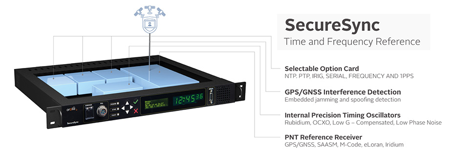
Orolia Defense & Security delivers M-code-enabled timing and synchronization to Lockheed Martin
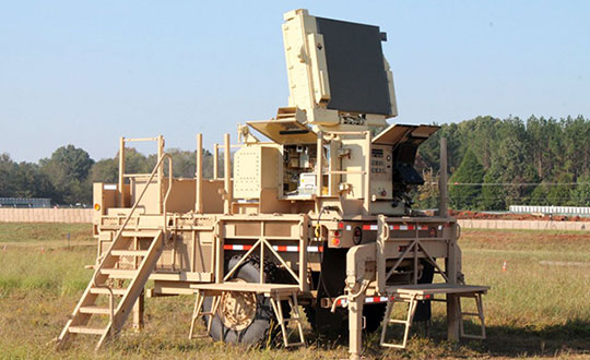
In September 2019, Lockheed Martin was awarded a contract to develop the U.S. Army’s Sentinel A4 radar system, an air and missile defense radar that will provide improved capability against dynamic threats.
The following November, Orolia Defense & Security announced the availability of M-code military GPS receivers in its flagship SecureSync — the first time server approved by the Defense Information Systems Agency.
Orolia is supplying SecureSync units for Lockheed Martin’s Sentinel A4 radar. (Photo U.S. Army)
This May, Orolia delivered a shipment of M-code-enabled SecureSync mission timing and synchronization units to Lockheed Martin, marking a key milestone for the Army program. SecureSync with M-code provides enhanced resilient positioning, navigation and timing (PNT) capabilities and improved resistance to existing and emerging GPS threats, such as jamming and spoofing.
Lockheed Martin selected Orolia’s SecureSync M-code as the A4 system’s resilient time and frequency reference solution in part due to its modular, open architecture – the same characteristics that are the cornerstone of the radar’s design – making integration a simple process and ensuring future upgrades.
“As a trusted Lockheed Martin partner, Orolia is proud to support the development of the Sentinel A4, which will be a key asset to our warfighters for decades to come,” said Hironori Sasaki, president of Orolia Defense & Security. “Making M-code available now in a readily configurable and scalable form factor is a critical step in advancing our forces out in the field, whether in the air or on the ground,” Sasaki added.
The next-generation of U.S. military systems are fortified with M-code, and Orolia leads the industry in M-code solutions for navigation warfare (NAVWAR) environments.
Orolia is supplying SecureSync units for Lockheed Martin’s Sentinel A4 radar. (Photo U.S. Army)
BAE Systems is developing an advanced military GPS receiver and improving the capabilities of size-constrained and power-constrained military GPS applications, including precision-guided munitions and handheld devices.
Spirent Federal is qualified to provide essential test equipment and support in the pursuit of resilient, accurate PNT data in GPS-degraded Navigation Warfare (NAVWAR) situations, Spirent stated in a press release.
The Spirent CRPA Test System is a development of its GSS9000 Series platform. It can test
controlled reception pattern antennas (CRPAs)
MNSA and AES M-code
jamming and spoofing threats and mitigation
ultra-high-dynamic vehicle applications
inertial navigation systems
additional encrypted military signals, Y-code and SAASM
and more
CRPAs provide proven and effective protection against jamming in high-interference environments. The Spirent CRPA Test System can simulate 16+ individual elements with a separate RF output per antenna element.
For the 16-element test system, concurrent simulation of GNSS signals, signals from spoofers and repeaters, and interference from multiple jammers — including Blue Force Electronic Attack (BFEA) jamming waveforms — results in more than 1,000 simultaneous independent channels and signals simulated across a phase-calibrated precise wavefront.
“The CRPA Test System is the culmination of over 35 years of R&D and industry leadership and is perfectly positioned to help with next-generation MGUE modernization,” said Ellen Hall, president/CEO of Spirent Federal. “Our robust M-code test capabilities support BAE Systems’ advances in M-code technology.”
Spirent can provide GNSS and interference signal simulation solutions for every stage in the CRPA design and verification process. To learn more, visit Spirent Federal’s CRPA Test System page.
Electronic Warfare Kit enables dismounted soldiers to detect, map and mitigate the impact of navigational warfare (NAVWAR) attacks
TRX Systems, developer of NEON GPS-denied location solutions, has delivered the TRX Systems Dismount Electronic Warfare (EW) Kit prototype to the U.S. Army.
Developed for U.S. Army Rapid Capabilities and Critical Technologies Office (RCCTO), the TRX EW Kit is designed to extend EW and signal intelligence for the dismounted warfighter.
The kit adds powerful new capabilities to the company’s NEON Personnel Tracker-MIL solution, expanding the integration between its NEON Location Service and ATAK application to better equip dismounted personnel for detection and mapping of jamming and spoofing attacks.
New NEON functionality includes:
Robust Interference Detection. Rapidly detects and geo-references NAVWAR threats including GPS jamming, repeating and spoofing.
NAVWAR Threat Mapping. Increases situational awareness by geo-referencing and mapping detected threats through integration with ATAK and EW platforms.
Reliable Dismount Location Data. Mitigates the impact of NAVWAR attacks by eliminating erroneous GPS inputs while continuing to deliver reliable location data to dismounted users.
Integration with NAVWAR Devices. Integrates threat data from Orolia Defense & Security BroadSense Nano and other devices already carried by warfighters to provide a fused NAVWAR threat indication.
The NEON Personnel Tracker Military (PT-MIL) uses a suite of patented algorithms that fuse GNSS, an inertial sensor, ultra-wideband (UWB) and other inputs to deliver reliable position data to dismounted personnel operating in the presence of compromised or intentionally denied GNSS signals.
With the new EW Kit functionality, warfighters will receive real-time situational awareness into jamming or spoofing threats at their immediate location and from other dismount personnel sharing data over the TAK network.
The EW Kit is integrated via soldier plug-ins, enabling threats discovered and mapped by dismounts to be fused into the overall NAVWAR threat picture.
“In today’s conflict zones, it’s becoming increasingly easy for adversaries to launch electronic attacks against GNSS systems using low-cost jammers built with readily available commercial technology,” said Carol Politi, president and CEO of TRX Systems. “The EW Kit developed in the RCCTO program provides dismount soldiers with clear insight into their NAVWAR environment by rapidly detecting and characterizing these NAVWAR attacks, and it mitigates the impact by eliminating compromised data from their position solution.”