No, I’m not talking about the line at the grocery store to buy toilet paper and hand sanitizer. Or the line at the doctor’s office. I’m talking about that gray privacy line invisible to the naked eye, but all too accessible on our mobile devices.
On March 16, Israeli Prime Minister Benjamin Netanyahu and his cabinet approved using citizens’ smartphones to track the locations of people infected with the novel coronavirus (COVID-19), as well as anyone they might have had contact with.
Such a strategy might work — some citizens reported receiving smartphone alerts when they were near an infected person. However, it does raise the ubiquitous privacy concerns of allowing your government to know your every move.
Some may think this an acceptable use of tracking, except that the Israeli Knesset — the citizenry’s representative legislature — was not involved in the decision. The tracking didn’t require a court order, and records were to be kept until the new regulation expired.
A few days later, Israel’s top court put a stop to the program, saying there would be no tracking of Israelis by the Shin Bet without Knesset oversight.
Of course, Israel is a democracy, and Netanyahu’s move is nowhere near the draconian measures undertaken by the Chinese government in response to the virus. Those actions included forcibly removing people from their homes and placing them in quarantine.
Yet China’s actions worked. As of press time, the outbreak there is under control, with no new cases reported on March 19. That’s impressive, if one can trust the state news. After all, this is the same country that warned the doctor who discovered the virus not to talk about it. Dr. Li Wenliang died in February of the disease.
Privacy versus public health: Something to think about while social distancing at home.
UPDATE: Israel’s High Court of Justice put a stop to the tracking on Thursday, March 19. The court declared that the Shin Bet security service may not track confirmed and suspected coronavirus patients if a Knesset panel to oversee this practice isn’t set up by noon Tuesday, according to Israel news agency Haaretz.
Israel’s internal security agency Shin Bet is using citizens’ smartphones to track the locations of people infected with the novel coronavirus (COVID-19) as well as anyone they might have had contact with, news agencies are reporting. Some citizens report receiving smartphone alerts when they have been near an infected person.
Privacy concerns. The tracking doesn’t require a court order and records will be kept until the regulations expire, according to Israeli news source Haaretz. The regulation can be renewed, and the country’s Health Ministry can keep the location records for 60 days after the regulation expires.
Israeli Prime Minister Benjamin Netanyahu told The New York Times that the government would approve the plan Monay night. “We have to maintain the balance between the rights of the individual and needs of general society, and we are doing that,” he told the newspaper.
No legislature involved. The plan was reportedly approved by cabinet members without approval of the Knesset, the Israeli legislature, which has just been sworn into office and has not yet convened.
The U.S. Supreme Court ruled June 22 that the government needs a warrant to access a person’s cellphone location history.
In the case Carpenter v. United States, the American Civil Liberties Union represented a man who had months of his cellphone location information turned over to law enforcement without a warrant. Investigators received the cell tower records with a court order that requires a lower standard than the “probable cause” needed to obtain a warrant.
The court found in a 5-to-4 decision that obtaining such information is a search under the Fourth Amendment and that a warrant from a judge based on probable cause is required.
“This is a groundbreaking victory for Americans’ privacy rights in the digital age,” said ACLU attorney Nathan Freed Wessler, who argued the case before the court last November. “The Supreme Court has given privacy law an update that it has badly needed for many years, finally bringing it in line with the realities of modern life.
“The government can no longer claim that the mere act of using technology eliminates the Fourth Amendment’s protections. Today’s decision rightly recognizes the need to protect the highly sensitive location data from our cell phones, but it also provides a path forward for safeguarding other sensitive digital information in future cases — from our emails, smart home appliances, and technology that is yet to be invented.”
Case background
In 2011, without getting a probable cause warrant, the government obtained from cell service companies months’ worth of phone location records for suspects in a robbery investigation in Detroit. For one suspect, Timothy Carpenter, the records covered 127 days and revealed 12,898 separate points of location data. Police seek these kinds of cellphone location records from phone companies tens of thousands of times each year.
After Carpenter was convicted at trial, based in part on the cellphone location evidence, he appealed to the Sixth Circuit Court of Appeals, which ruled 2–1 that no warrant is required under the Fourth Amendment.
The Supreme Court said in its opinion today, “We decline to grant the state unrestricted access to a wireless carrier’s database of physical location information. In light of the deeply revealing nature of CSLI, its depth, breadth and comprehensive reach, and the inescapable and automatic nature of its collection, the fact that such information is gathered by a third party does not make it any less deserving of Fourth Amendment protection. The government’s acquisition of the cell-site records here was a search under that amendment.”
Tech companies and media weigh in
Among the many friend-of-the-court briefs filed in the case is the one from technology companies, which was signed by Google, Facebook, Apple, Verizon, Twitter, Cisco, Microsoft and others. They echoed the ACLU’s arguments, writing that “Fourth Amendment doctrine must adapt to the changing realities of the digital era” and that “Rigid analog-era rules should yield to consideration of reasonable expectations of privacy in the digital age.”
In another friend-of-the-court brief, the Reporters Committee for Freedom of the Press and 19 other media organizations warned of the chilling effect on First Amendment freedoms that can result from easy law enforcement access to the location information of reporters and their sources.
Third-party doctrine
The government’s argument was based on the “third-party doctrine,” which the government reads to provide that by sharing information or records with a “third party” such as a business, a person gives up any reasonable expectation that the information will remain private. The doctrine was established in Supreme Court cases from the 1970s, which reasoned that without an expectation of privacy, there is no Fourth Amendment protection for certain records voluntarily shared with businesses, such as canceled checks sent to a bank or phone numbers dialed on a phone and transmitted over a phone company’s equipment. The government has extended that principle to cover various kinds of digital records, such as cell phone location data.
“The court’s decision is a vindication of the arguments we have persistently made on behalf of Timothy Carpenter throughout this litigation — that the Constitution’s privacy protections fully apply to the digital location data created by using cell phones,” said attorney Harold Gurewitz, who represents Carpenter alongside the ACLU. “The ruling also affirms that prosecutors are required to get a search warrant in order to seize this kind of sensitive personal information.”
The data acquired by police in the case provides a stark demonstration of how location data can reveal extraordinarily private details about people’s lives, from where they sleep to where they pray.
For example, the location data showed that in the early afternoon on a number of Sundays, Carpenter made or received calls from the cell tower sectors nearest to his church. His cellphone records do not routinely show him in that area on other days of the week, implying that he was worshipping at those times. The data also shows which nights he slept at or near his home, and which nights he spent elsewhere.
Carpenter is represented at the Supreme Court by the ACLU, the ACLU of Michigan, defense attorney Gurewitz of Gurewitz & Raben PLC, and Jeffrey Fisher, co-director of the Stanford Law School Supreme Court Litigation Clinic.
The U.S. Supreme Court heard arguments last week on a case that could determine whether authorities can search cellphone location data without a warrant.
In Carpenter v. U.S., the Court will eventually rule on whether the Fourth Amendment of the U.S. Constitution’s Bill of Rights, enacted in 1791 to safeguard citizens’ rights against unreasonable searches and seizures, extends to cover personal cellphone records tracking user location.
The case began when police used records, obtained from a phone company and drawing on cell-tower location, to show that an individual’s cellphone was used in the vicinity of several armed robberies in Michigan and Ohio in 2010 and 2011.
The appellants contend that the government had violated the Fourth Amendment when it collected their cellphone location records without a warrant. A federal appeals court ruled against the appeal, finding the Fourth Amendment doesn’t “yet” extend to cellphone location data.
That court distinguished between the “content” of a communication and the “information necessary to send it.” The government can’t read letters or emails or listen to wiretapped conversation without a warrant, but it is entitled to the metadata used to send such content — in this case the phone company data showing in which tower’s cell area the phone was activated.
“The business records here fall on the unprotected side of this line. Those records say nothing about the content of any calls,” the court ruled. “Instead the records include routing information, which the wireless providers gathered in the ordinary course of business.”
The Supreme Court, in hearing the appeal on this decision, is expected to review — and possibly revise — its heretofore opinion that when users share information with a third party, such as a bank or telephone company, they lose the expectation that it will remain private. At question is whether cellphones have activated a new era of privacy expectations, in essence, whether legal doctrine needs to be subject to updates for the digital age.
One tenet that no one questions is that cell phone users have no idea to what extent their phone companies know where they go and how long they stay there. Whether they care or not, or whether they are willing to sacrifice some amount of privacy for the convenience of cell phone access, remains to be seen. The limits for this have been explored but never completely settled, in controversies around Facebook’s (and others’) access to and use of customer data and profiles.
Apple, Facebook, Google and Verizon have all filed an amicus (“friend of the court”) brief in Carpenter v. U.S. The tech gargantua seem to want, on the one hand, to discourage the possibility of government and law enforcement being able to access location data without a warrant, while also maintaining a clear and unencumbered route for themselves to use it. They argue that “Fourth Amendment doctrine must adapt to the changing realities of the digital era” and that “rigid analog-era rules should yield to consideration of reasonable expectations of privacy in the digital age.”
After a related 2012 Supreme Court decision that attaching a GPS tracker to a car without a search warrant violated the Fourth Amendment, Justice Sonia Sotomayor wrote that the so-called third-party doctrine was “ill suited to the digital age” and that privacy case law should adapt to changes in society’s views that are occurring thanks to smartphones and other technology.
For a summary of the arguments presented to the Court on November 29 in Carpenter v. U.S., see the SCOTUS blog here. Further developments in the case will appear on this page, and viewers may sign up for push updates as well.
In 2008, GPS World published an editorial on this subject, in the guise of a parodized future film noir scenario, “The Call Tease Factor.” An expandable image appears at left. The essay opined that “Government agencies and police routinely tracked cell users’ location without a warrant or court oversight. . . . Challenges had faltered, and no one seemed to notice any more, or care much.”
“Privacy, as least as far as location, no longer existed.”
AeroScope addresses safety, security and privacy concerns while protecting drone pilots
DJI has unveiled AeroScope, its new solution to identify and monitor airborne drones with existing technology that can address safety, security and privacy concerns.
AeroScope uses the existing communications link between a drone and its remote controller to broadcast identification information such as a registration or serial number, as well as basic telemetry, including location, altitude, speed and direction.
Police, security agencies, aviation authorities and other authorized parties can use an AeroScope receiver to monitor, analyze and act on that information. AeroScope has been installed at two international airports since April, and is continuing to test and evaluate its performance in other operational environments.
“As drones have become an everyday tool for professional and personal use, authorities want to be sure they can identify who is flying near sensitive locations or in ways that raise serious concerns,” said Brendan Schulman, DJI’s vice president for policy and legal affairs. “DJI AeroScope addresses that need for accountability with technology that is simple, reliable and affordable — and is available for deployment now.”
DJI demonstrated the system Oct. 12 in Brussels, Belgium, showing how an AeroScope receiver can immediately sense a drone as it powers on, then plot its location on a map while displaying a registration number. That number functions as the equivalent of a drone license plate, and authorities can use it to determine the registered owner of a drone that raises concerns.
In March 2017, in response to growing calls by governments worldwide for remote identification solutions, DJI released a white paper describing the benefits of such an approach to electronic identification for drones.
AeroScope works with all current models of DJI drones, which analysts estimate comprise more than two-thirds of the global civilian drone market. Since AeroScope transmits on a DJI drone’s existing communications link, it does not require new on-board equipment or modifications, or require extra steps or costs to be incurred by drone operators. Other drone manufacturers can configure their existing and future drones to transmit identification information in the same way.
Because AeroScope relies on drones directly broadcasting their information to local receivers, not on transmitting data to an internet-based service, it ensures most drone flights will not be automatically recorded in government databases, protecting the privacy interests of people and businesses that use drones. This approach also avoids substantial costs and complexities that would be involved in creating such databases and connecting drones to network systems.
This system is consistent with DJI’s problem-solving approach to drone regulation, which aims to strike a reasonable balance between authorities’ need to identify drones that raise concerns and drone pilots’ right to fly without pervasive surveillance.
DJI has led the industry with safety and security advances such as geofencing and sense-and-avoid technology, and believes the rapid pace of innovation provides the best means to address new policy concerns.
Drone identification settings will be included in DJI’s initial drone software to allow customers to choose the content of their own drone’s identification broadcast to match local expectations both before and after identification regulations are implemented in different jurisdictions.
To protect customers’ privacy, the AeroScope system will not automatically transmit any personally identifiable information until regulations or policies in the pilot’s jurisdiction require it.
“The rapid adoption of drones has created new concerns about safety, security and privacy, but those must be balanced against the incredible benefits that drones have already brought to society,” said Schulman. “Electronic drone identification, thoughtfully implemented, can help solve policy challenges, head off restrictive regulations, and provide accountability without being expensive or intrusive for drone pilots. DJI is proud to develop solutions that can help distribute drone benefits widely while also helping authorities keep the skies safe.”
As government agencies expand their use of cell-site simulators or “stingrays” and other digital tracking technology, Sen. Ron Wyden, D-Ore., Rep. Jason Chaffetz, R-Utah, and Rep. John Conyers, Jr., D-Mich., introduced the Geolocation Privacy and Surveillance Act (known as the GPS act) to create clear rules for when agencies can access and track an individual’s geolocation information.
Chaffetz introduced the House version of the bill on March 6, with four Republican and three Democratic cosponsors. Wyden introduced the Senate bill Feb. 15.
Courts have issued conflicting opinions about whether the government needs a warrant to track Americans through their cell phones and other GPS devices. The Supreme Court unanimously ruled in 2012’s U.S. vs. Jones case that attaching a GPS tracking device to a vehicle requires a warrant, but it did not address other digital location tracking, including through cell phones, OnStar systems and consumer electronics devices.
The GPS Act applies to all domestic law enforcement acquisitions of the geolocation information of individual Americans without their knowledge, including acquisitions from private companies and direct acquisitions through the use of cell-site technology. It would also combat high-tech stalking by creating criminal penalties for surreptitiously using an electronic device to track a person’s movements, and it would prohibit commercial service providers from sharing customers’ geolocation information with outside entities without customer consent.
Wyden and Chaffitiz have now introduced versions of the GPS Act four times since 2011. Though hearings have been held, the Act has yet to make it out of committee for a vote.
“Outdated laws shouldn’t be an excuse for open season on tracking Americans, and owning a smartphone or fitness tracker shouldn’t give the government a blank check to track your movements,” Wyden said. “Law enforcement should be able to use GPS data, but they need to get a warrant. This bill sets out clear rules to make sure our laws keep up with the times.”
“Congress has an obligation to act quickly to protect Americans from violations of their privacy made possible by emerging technologies,” Chaffetz said. “As we welcome innovative technologies that help fight crime, we must be mindful of the potential for abuse. This bill will build a framework governing the use of geolocation and cell site simulator technologies.”
“We must enact the Geolocation Privacy and Surveillance Act to require the government to obtain a warrant based on probable cause to compel companies such as cell phone service providers to disclose the geolocation information of their customers,” said Rep. John Conyers, Jr. (MI-13). “Geolocation tracking, whether information about where we have been or where we are going, strikes at the heart of personal privacy interests. The pattern of our movements reveals much about ourselves. When individuals are tracked in this way, the government is able to generate a profile of a person’s public movements that includes details about a person’s familial, political, professional, religious, and other intimate associations. That is why we need this legislation to provide a strong and clear legal standard to protect this information.”
Support for the Act
Technology and civil rights organizations praised the bill’s introduction.
Neema Singh Guliani, legislative counsel at the American Civil Liberties Union: “In today’s world, most Americans use cell phones or other electronic devices that are capable of tracking their every move, including visits to a mosque, doctor’s office, domestic violence shelter, or political rally. This information that the government should not be able to get without a warrant – yet law enforcement routinely fails to meet this standard. Congress should swiftly pass the GPS Act to protect this sensitive information.”
Gabe Rottman, deputy director of the Freedom, Technology & Security Project at the Center for Democracy and Technology: “As we move into the world of connected devices, and as the sheer number of these devices grow, location tracking becomes more accurate, and more revealing. Basic notions of American privacy necessitate passage of this important reform to require a warrant for location tracking.”
Amie Stepanovich, U.S. policy manager at Access Now: “Computer scientists have proven that even a few location points can be used to reveal incredibly broad and personal information about an individual. At the same time, ever more devices are collecting our location data. Law enforcement agencies are using an increasingly sophisticated array of technology to obtain that information without proper legal protections. What you don’t know can hurt you. Access Now applauds the GPS Act for protecting this sensitive information and mandating a warrant requirement for law enforcement access.”
Lee Tien, senior staff attorney at the Electronic Frontier Foundation: “Geolocation data paints a detailed portrait of our daily lives that reveals sensitive information about us and our families — whether a visit to a children’s cancer specialist or to a church, synagogue or mosque. The government shouldn’t be able to track us without a warrant just because we use cellphones. The GPS Act ensures all Americans have strong legal protections for their geolocation data.”
On Nov. 25, 2015, President Obama signed the National Defense Authorization Act (NDAA) for Fiscal Year 2016, after vetoing a previous version. The enacted NDAA complies with the two-year budget agreement, which called for a reduction in defense spending.
The act reduces the GPS IIF line item by $2 million, citing “unjustified support growth” from the U.S. House of Representatives Committee on Appropriations, but otherwise recommends full funding for the Air Force GPS program ($936.775 million).
The NDAA also includes three GPS-related policy provisions: Reporting Requirement (Section 1621), Oversight Council (Section 1603), and M-Code Equipage (Section 1605).
New Space Law Mentions PNT Coordination Office
On Nov. 25, the president also signed the U.S. Commercial Space Launch Competitiveness Act. Title III of the act codifies the support that the Department of Commerce (DOC) provides to the National Coordination Office for Space-Based PNT.
Specifically, it tasks DOC’s Office of Space Commerce “to provide support to federal government organizations working on Space-Based Positioning, Navigation, and Timing policy, including the National Coordination Office for Space-Based Position, Navigation, and Timing.”
Senator Franken Reintroduces GPS Data Privacy Bill
On Nov. 10, Sen. Al Franken (D-MN) reintroduced the Location Privacy Protection Act, which he also introduced during the 112th and 113th Congresses. According to the Senator, “The Location Privacy Protection Act of 2015 closes legal loopholes that allow stalking applications to exist on smartphones.
Sen. Franken’s bill fixes this problem by requiring companies to get customers’ permission before collecting their location data or sharing it with third parties.” The bill joins several others in the 114th Congress that address geolocation privacy issues, including the Geolocation Privacy and Surveillance Act (“GPS Act”) and the Online Communications and Geolocation Protection Act.
The summaries here are from the GPS Bulletin, which is available through the gps.gov website.
Gov. Jerry Brown signed legislation Tuesday to expand privacy protections to prevent paparazzi from flying drones over private property, reports sUAS news.
The bill, AB 856, changes the definition of a “physical invasion of privacy” to include sending a drone into the airspace above someone’s land to make a recording or take a photo.
Brown previously vetoed in September a proposal that would have made flying a drone above someone’s property without permission a trespassing violation, writing in a veto message, “While well-intentioned, [the bill] could expose the occasional hobbyist and the FAA-approved commercial user alike to burdensome litigation and new causes of action.”
The governor also rejected three bills that would have prohibited civilians from flying aerial drones over wildfires, schools, prisons and jails. Some of the proposals were intended to prevent interference with firefighting aircraft — a recurring problem, according to fire officials — and prevent inmates from receiving airborne contraband. Brown rejected the bills because they would create new crimes.
MAPPS, the national association of private-sector geospatial firms, released a Best Practices Guideline for firms’ handling of geospatial data to protect individual citizen privacy.
In an effort to establish best practices, principles and a self-regulatory framework for its member firms, a MAPPS task force led by MAPPS President Susan Marlow (Stantec, Nashville, Tenn.) drafted the guideline.
The guideline was developed in response to a March 2012 report of the Federal Trade Commission (FTC), report Protecting Consumer Privacy in an Era of Rapid Change, in which “the Commission calls on individual companies, trade associations, and self-regulatory bodies to adopt the principles contained in the final privacy framework.”
The FTC sought to protect the privacy of individual citizens’ “sensitive” data, including “precise geolocation data” that included, for example, an address. However, FTC did not define the term “precise geolocation data” and recommended that before any firm could collect, store, or use such data, it would be required to “provide prominent disclosures and obtain affirmative express consent before using consumer data in a materially different manner than claimed when the data was collected…”
The MAPPS guideline provides assistance to firms when determining when it should obtain individual consent for collection of geospatial data and when it is not needed to protect privacy. It was released at the association’s annual conference held in July in Sunriver, Ore.
“Recent legislative and regulatory efforts to protect consumers and citizens in the name of privacy have cast a wide net, creating unintended consequences for mapping and geospatial firms,” said John Palatiello, MAPPS executive director. “Geospatial data is derived from images and data collected from a variety of airborne and space borne platforms, as well as other mobile and terrestrial-based acquisition systems. This imagery and data is collected, utilized and applied in geographic information systems (GIS) by companies operating within the safeguards, rights and framework established by the Fourth and 14th Amendments to the Constitution of the United States, and with government often the client. This document helps engage in lawful, ethical and professional practice that is respectful of individual citizens.”
Reasons Cited Include Privacy, Lack of Retail Support
Kevin Dennehy
Google Here, a proposed beacon-based location service operating within Google Maps, was reportedly cancelled due to a concern by Alphabet CEO Larry Page’s that it would be too invasive by the users of his mapping service. When the location industry has such a dominant player pull out of a nascent, and potentially lucrative, proximity service, does it mean that consumers will now have to wait for a full-scale rollout? Google will remain a major player with its Google Maps app, but where does it go from there?
Citing privacy issues and lack of retail partners for support, Google scraped its Google Here location service that would have used the company’s Maps technology to send notifications to users when they entered a specific location.
In a recent Fortune article, Alphabet CEO Larry Page said the company killed the project because it was too invasive to consumers, and the company was uncertain whether retail partners could have helped to roll out the service. Besides being in conflict with an existing location Here name (such as the former Nokia, and now German consortium, mapping service), the service included partnerships with retailers — and would have been available to more than 350 million Android users earlier this year.
Google makes money off of advertising through its Maps app, but the Fortune article said that the proposed Here location service would have made it even more valuable to advertisers.
So what does the location industry make of one of the largest players not rolling out a location service? To at least one analyst, it’s a “so what” report considering Google in July rolled out a new agnostic beacon service called Eddystone. “Somewhat curiously, the company appears to be moving forward with location-based advertising under the guise of the Eddystone project, so beacons and their use in location-based advertising seem still of interest — just not beacons combined with messaging that might make Google Maps an uncontrollable nag about shopping opportunities,” said Mike Dobson, Telemapics president.
Eddystone, a new format for Bluetooth Low Energy beacons, works with Google’s Android operating system along with Apple’s iOS and other platforms that connect through BLE.
Overall, Dobson believes that Google is approaching middle-age in terms of corporate development. “It is both developing a conscience about how its services really operate, as well as imposing economic constraints limiting how much the company is willing to spend to determine whether a potential market might be a big hit,” he said. “More specifically, it is my opinion that Google is slowly reining in the spending on new innovations for Google Maps, as well as the expenses associated with supporting the lakes in the data reservoir associated with their mapping product. Google may have finally realized that maintaining spatial data is expensive and a cost that is never going to decrease.”
Dobson also said that the Google Here program was going to be an expensive proposition. “My understanding of the Google Here program was that Google would provide the beacons and infrastructure and control delivery of the service through Google Maps. That’s a lot of beacons and associated support — in other words, more money,” he said. “Conversely, Eddystone appears to offer a standardized, industry-supported approach that is beneficial for Google and companies interested in testing the concept.”
Dobson said the name “Here” could have caused problems for Google. “Two other issues crossed my mind when I heard the news of the cancellation. First, who at Google forgot trademark law and thought they could combine the name of the well-known mapping company Here with Google?” he said. “Second, if I owned an application as successful as Google Maps is on mobile phones, I sure would not want to push my users to consider switching to a less-invasive mapping app. You know, that Larry Page guy sure seems to know his Alphabet.”
Big Competitors Getting into Beacons, with Huge Market Expected
Recent Allied Business Intelligence reports indicate that BLE beacon shipments will exceed 400 million units by 2020. While optimistic, and only five years away, ABI said that pure beacon shipment revenues will break $1 billion this year.
Google’s July entry into the location-beacon space is significant, if not surprising, to heat up the location market. However, competition is fierce as Apple, Facebook and Twitter now have dedicated BLE resources.
The location-beacon market is heating up as Gimbal, the Qualcomm spin-off company, installed approximately 1,300 BLE beacons in areas at South by Southwest. Gimbal said it was making its technology available to enable any BLE device to act as a dedicated location beacon.
Google plans to improve its own products and services through the Eddystone beacon technology, according to a company blog. Earlier this year, the company launched beacon-based transit notifications in Portland that enable users to get faster access to schedules for specific locations.
With rise in commercial location-based beacon technology comes a cross-over movement in public safety markets. TeleCommunication Systems, which bought Loctronix in July, is developing the indoor public safety and emergency market, along with Longmont, Colo.-based Intrado.
As detailed in last month’s Wireless LBS Insider column, beacons and Wi-Fi seem to be the lead technologies in use for emergency indoor location. Intrado installed 65 Apple iBeacons at the Washington Convention Center to showcase its developing indoor positioning technology at the APCO trade show.
It’s not all about beacons in this proximity/contextual location market. The analytical data derived from the beacon information will grow into a huge market. As we reported this summer, a new location analytics product is hitting the market in a more and more crowded indoor-positioning field.
Such companies as Cloud4Wi, with its Fogsense product, is tailored to retail outlets, coffee shops, restaurant chains and shopping malls with presence analytics and location-based services.
The device, which contains Broadcom’s WICED chip, features BLE technology in the new version in (the fourth quarter), said Elena Briola, Cloud4Wi’s chief marketing officer. The new BLE version will enable Apple iBeacon and location-aware mobile applications, the company said.
Editor’s note: Dennehy is GPS World’s editor for location-based services, writing a monthly column for the LBS Insider newsletter. The views expressed are his own. He will be covering the Mobile World Congress in Barcelona for GPS World. Contact him at [email protected] with your news.
Sen. Ed Markey’s new car technology report, released earlier this month, basically says that connected vehicles can be hacked, causing danger to drivers and presenting major privacy concerns. While some critics believe Markey’s report was meant to drive media hysteria, others say it raises serious issues that the industry needs to address. In other location news, I’ll be covering the Mobile World Congress in Barcelona for GPS World. What will be the showcased location technology? Wearables? Connected vehicles? Or something new?
Kevin Dennehy
By Kevin Dennehy
A report released by Sen. Edward Markey (D-Mass.) earlier this month says that even though drivers have come to rely on new connected technologies, automakers haven’t done their part to protect them from cyber attacks or privacy invasions
First reported by CBS News’ 60 Minutes, Markey’s report, Tracking & Hacking: Security & Privacy Gaps Put American Drivers at Risk, includes information from 16 automobile manufacturers who were given questions about security and privacy. However, few of the carmakers’ answers included how vehicles may be vulnerable to hackers — and what driver information is collected.
Location industry veteran Kim Fennell, deCarta CEO, said the report should be a real concern to the industry. “But it’s more of an issue for autonomous driving and the security of the car’s electronic control system. Even today, the OnStar service, which was a pioneer in the connected car space, can remotely slow your vehicle down in the event of a theft,” he said. “This feature, if hacked, could definitely create massive problems if the proper security technologies are not implemented.”
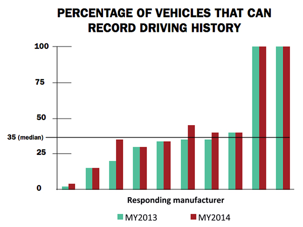
Markey’s report raised additional concerns about the use of navigation and other features that record and send location or driving history information.
Fennell said there should be a distinction between the infotainment systems in the vehicle and the on-board control systems of the car.
“We believe that there should be a strict firewall between these systems so that nothing malicious can happen that is initiated from the connected infotainment system. Any data should flow one way — from the control system of the car to the infotainment system,” he said. “This is not to say that the connected infotainment system shouldn’t be secure, it should be. In working with our OEM and Tier One partners, we have implemented strict security protocols between our servers and their apps.”
Markey’s report found that “[automakers] use personal vehicle data in various ways, often vaguely to ‘improve the customer experience’ and usually involving third parties, and retention policies — how long they store information about drivers — vary considerably among manufacturers.”
In addition, the report found that customers are often not made aware of data collection and, when they are, they often cannot opt out without disabling features, such as navigation.
Percentage of Vehicles that can record driving history
Overall, Fennell hopes that the most malicious thing that could happen in the event of a hack of an infotainment system is that a “Pandora station is changed to play nothing but Justin Bieber songs, the traffic information for your route is projected to be ridiculously long or the Yelp rating of the restaurant that you are going to is lowered down to one star.”
Ultimately though, the driver should be in control of the car and nothing in the infotainment system should affect the behavior of the vehicle, Fennell said.
In terms of driver safety, in a recent survey, deCarta found that more than two-thirds of respondents considered dashboard screens that display videos and other Internet content to be the most dangerous types of onboard information systems. Approximately 79 percent of those polled preferred “voice-activated mapping systems that allow drivers to keep their eyes on the road” as an essential safety-enhancing feature.
“There are two things that infotainment systems could do better to prevent driver distraction. First, instead of replicating the stove-piped app store environment of the smartphone, in-car infotainment services could be better integrated,” Fennell said. “If I find a destination on Yelp, I’d like to send that to my navigation system instead of typing in the address. Second, with today’s better automated speech-recognition technology and text-to-speech engines, it’s now possible to make requests of your infotainment system using natural language commands. Voicebox is doing some great things in this area.”
Fennell said that most existing systems are not connected. “But those that are, aren’t predictive enough. Your navigation/infotainment system should almost work as a concierge,” he said. “It should recognize what time it is and realize you are most likely leaving for work and offer up the best route based on traffic conditions. It should recognize that you are going to a destination in an urban area and offer the most convenient parking to your destination.”
Company Rolls out Indoor Positioning Product that Doesn’t Require Retailer Involvement
After testing and demoing the product in San Francisco last year, IndoorAtlas is rolling out a consumer app called GPSindoor, which uses smartphones to locate shoppers inside a mall. The product features product proximity advertising to allow shoppers to see where they are relative to a product for promotion marketing.
The product includes a crowdsourcing function to allow user-generated data to build indoor maps, wayfinding and other options for shopping promotions, said Wibe Wagemans, IndoorAtlas president.
“We don’t need any retailers per se. We need only the shopper and [their] smartphone,” he said. “There is no brand or retailer involvement if you use our app. Unlike Wi-Fi and Bluetooth beacons, since GPSindoor relies on a community of shoppers, it allows for higher accuracy than static maps. That gives us the confidence to take on the giants like Apple Beacons and Google Indoor Maps head on — we are completely independent of retailers and not dependent on them for our success in becoming the GPS of indoors.”
In other location news:
HERE released a new version of its mapping system for Android, saying it made significant improvements. According to the company’s blog, after more than 3 million downloads, it is shedding the “beta” label with this version. In the beta version, when users asked for a route, the app gave them three car routes. If a user wanted public transit or pedestrian routes, they had to switch to the appropriate tab. This process was slow and inconvenient for people who don’t use a car all the time, HERE said.
In its recent financial statements, Garmin indicated a growing, and profitable, segment is its wearables/fitness band product line. Mio is also expanding its wearable offerings. This should be a big topic at next months’ Mobile World Congress.
I’ll be covering the Mobile World Congress in Barcelona for GPS World. Contact me at [email protected] with your news.
The Mobile Marketing Association (MMA), a global trade association for the mobile marketing industry, is forming a Mobile Location Data Accuracy Group. The focus of the group will be to eliminate any confusion around mobile location data and to improve the trust and confidence brand marketers and agencies have in mobile location advertising and the data that drives it.
Simultaneously, the MMA is forming a Location Leadership Council that will be an industry “think tank” comprised of a merging together of thought leaders from the MMA’s Location and Privacy committees and experts in the various areas of location — marketing, technology, data and policy. Stemming from the council will be a number of working groups, the first of which is the Mobile Location Data Accuracy Group.
The working group will expand on the previously launched Location Terminology Guide, in which the MMA Location Committee identified eight types of location data and signals, and ranked each according to the reach and accuracy of the data. The data and signals to be examined by the working group include (from most accurate to least):
Indoor positioning system
Bluetooth
GPS
Wi-Fi hotspots
Wi-Fi triangulation
Cell tower triangulation
IP address
User reported location
Specifically the Mobile Location Data Accuracy Group will:
Dig deeper into each of these data types and elaborate further on their appropriate uses and limitations.
Develop and issue an RFI (Request for Information) to all location data vendors and validators that will establish criteria with which vendors can be aligned with the data types they use.
Establish strict, standardized definitions with the MRC that vendors will be held accountable to and audited against.
According to an April 2014 BIA/Kelsey study on local media spending, location targeted mobile advertising accounted for 40% of the $7.22 billion mobile ad spend in 2013, and is expected to grow to 52% of the $30.3 billion forecasted for 2018.
“In order to scale mobile marketing specifically driven by location data, it is critical for the industry to come together to develop a common set of definitions of the types of location data available and how they are best used,” said Greg Stuart, CEO, MMA. “By agreeing to and abiding by a common set of best practices and guidelines, MMA members will be instrumental in driving the growth in the industry while assuring brand marketers of the measurable value derived from their mobile efforts.”
With tighter definitions of location data, and the viable uses of such data, measuring results will be more consistent and reliable, the MMA said. These benchmarks will allow buyers to have a much clearer understanding of the data being used, and how it will impact their location-driven mobile advertising campaigns.
Initial members of the group will include:
xAd – Monica Ho, SVP Marketing (co-chair)
Joule – Michael Lieberman, CEO (co-chair)
Factual – Vikas Gupta, Director of Marketing
ThinkNear – Brett Kohn, Director of Marketing
Mobiquity – James Meckley, CMO
Nielsen – Tom Eaton, VP, Client Services
MEC – Bav Panchal, Mobile
OpenX – Rob Kramer, GM, Mobile
Ubimo – Ran Ben-Yair, CEO
Verve – James Smith, CRO
“Having this type of transparency into location data is a huge step forward that will allow us, as buyers, to invest in mobile with increased confidence,” said Michael Lieberman, CEO, Joule North America. “This program will, in large part, allow mobile marketing to truly scale and deliver measurable results for our clients around the world.”
“We are committed to improving clarity and defining auditable standards for location data and ultimately all of location-based services. This will remove the barriers for brands and agencies to leverage the power of this unique mobile value proposition and improve their confidence in how and what to use,” said Monica Ho, SVP Marketing, xAd. “We are excited to work with the MMA and the industry in achieving standards that we believe will be critical for scaling the mobile marketing industry.”
The Mobile Location Data Accuracy Group will be gathering the industry leaders to share initial definitions and use cases at the Location Data Accuracy Panel Session August 26 at the Crowne Plaza Times Square, New York, 6:30-9 p.m. The session will provide an opportunity for brands, agencies and key partners in the location advertising arena to meet and discuss opportunities ahead.