BDStar Navigation subsidiary TruePoint has introduced the TruePoint.CM network real-time kinematic (NRTK) service across Europe, the latest in BDStar’s expansion into international high-precision positioning markets.
Supporting all major GNSS and QZSS, the service is designed to improve signal reliability in complex European environments. TruePoint.CM is built on the company’s chip-cloud integration architecture and works with both BDStar’s Unicore and third-party GNSS hardware through standards-based interfaces.
The service provides wide-area coverage throughout Europe, the company said, offering centimeter-level accuracy with fast convergence times. Before launch, TruePoint conducted extensive validation testing in more than 40 cities across 12 European countries, including more than 300,000 kilometres of dynamic field trials.
The platform uses an adaptive data protocol to reduce bandwidth consumption by up to 70% while maintaining full positioning accuracy, a feature aimed at helping customers reduce operational data costs. Remote diagnostics and over-the-air firmware updates are incorporated to support more efficient device management in the field.
TruePoint.CM operates on a fully redundant cloud infrastructure spanning data sources, data centers and service-delivery interfaces. The system is designed to ensure continuous uptime, backed by a stated service availability of 99.9%.
At launch, the company reported that it has already secured commercial adoption in the European robotic lawn mower market, with additional opportunities expected in autonomous robotics, UAVs, precision agriculture, automotive and consumer IoT.
STMicroelectronics has partnered with Segway to enhance its latest range of robotic lawnmowers. The collaboration integrates precision positioning and extended satellite-signal coverage, designed to improve operational efficiency and safety.
Reliable satellite navigation is essential for robotic lawnmowers that operate without boundary wires. These devices must autonomously navigate safely, even in areas where tall buildings or trees obstruct satellite signals. Uninterrupted satellite signal coverage is critical for functioning at the edge of stairs or steep slopes.
STMicroelectronics’ Teseo satellite navigation chips — with automotive-grade quality and reliability — are well-suited for robotic lawnmowers. These chips enable decimeter-level location accuracy, ensuring the mower remains within its designated field perimeter.
Segway’s recently launched Navimow X3 robotic lawnmowers incorporate ST’s Teseo V single-chip triple-band GNSS receivers. These receivers track multiple satellite constellations simultaneously, delivering superior performance in challenging environments. The real-time kinematic (RTK) technique further corrects satellite signal errors, ensuring stable operation in complex layouts such as properties with narrow passageways or multiple mowing zones. The company said that compared to earlier models, Segway reports a 20 to 30% increase in satellite signal coverage with ST’s technology.
Technical specifications include ST’s STA8135GA GNSS receiver from the Teseo V family. This automotive-qualified chip integrates triple-band positioning measurement and dead-reckoning features within a compact package. On-chip voltage regulators simplify power supply selection, further enhancing design efficiency.
Harxon has released two high-precision GNSS antennas suitable for robotic lawn mowers.
The HX-CSX014A is a high gain, low profile and compact antenna with a new structure that simplifies integration into lawn mowers and minimizes the overall machine dimension. It features small size, high sensitivity and low power consumption.
The HX-CSX231A, is a ready-to-use GNSS antenna with a highly reliable structure that makes it small and lightweight. It exhibits 4.5 dBi high gain performance with ultra-low signal loss. It also delivers wide beam width that covers wide frequencies with high marginal gain, a perfect option in complex environments.
Additionally, the HX-CSX231A’s advanced LNA features improved signal filtering, out-of-band rejection, restrained unwanted electromagnetic interferences and a strong multi-path reduction capacity.
To learn more about Harxon high precision GNSS solutions for lawn mowers, click here.
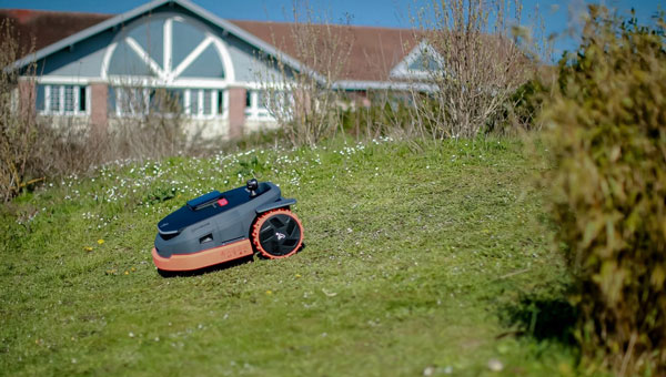
ComNav Technology now provides a GNSS high-precision positioning solution for navigation and positioning of autonomous lawn mowers. Environmentally friendly and intelligent robotic lawn mowers are growing more popular, making the mowing task easier, safer and more convenient.
R&D background
It is difficult to develop autonomous lawn mowers because they obtain navigation information by means of visual and acoustic sensors, usually through embedded cables in the working area and detection through eddy current sensors. The shortcomings are obvious: before the mower starts, it must be set up with cables and other equipment. Cable requirements differ in various countries, and cable laying can be complicated, wasting resources and money.
With these difficulties in mind, ComNav applied its K8 series of GNSS high-precision modules to lawn mowers to break through the application limit. It solved this accuracy problem to make the lawn mower achieve centimeter-level driving according to the setup path in an open field. With ComNav’s other technologies — quantum algorithm and LAI, HighLock, PPP, RTK-KEEP — the law mowers continues to operate under trees, around corners or in other obscured areas.
Introduction of ComNav’s solution
With the K8 series module, ComNav facilitates the lawn mower’s fieldwork with position data provided by GPS, GLONASS, Galileo, Beidou, QZSS, IRNSS and SBAS.
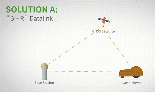
The high-precision positioning system for lawn mowers consists of a base station and a rover station. Three solutions are recommended for the terminal to obtain differential data from the base station.
Base and rover datalink. A base station acquires differential data through a datalink and provides corrections to the rover. The rover station — comprising the parts installed on the lawn mower, including the GNSS antenna, the GNSS high-precision module, datalink and UHF antenna — enables centimeter-level positioning and navigation.
Image: ComNav
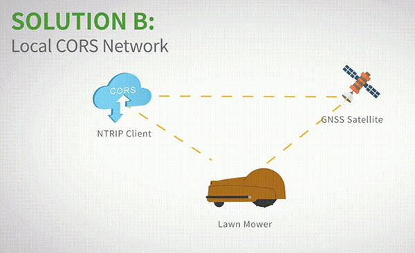
Local CORS network. Utilizing existed local CORS, the rover station obtains differential data from the CORS service, enabling the lawn mower to achieve positioning and navigation accuracy on a centimeter level.
Image: ComNav
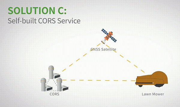
Self-built CORS network. Base stations can be placed anywhere based on requirements. Doing so eliminates the worry about prevailing conditions and makes high-precision positioning and navigation of lawn mowers possible.
Image: ComNav
Technology Features
LAI technology. ComNav’s patented low-power anti-interference (LAI) technology provides a jamming-to-signal ratio of up to 50 dB. Power consumption is only 0.1 W when turned on. By quickly detecting and eliminating interference with simple settings, LAI technology can reduce failure time and ensure safe operation. The technology can generate a spectrum diagram of interference sources, enabling identification of interference types and potential interference sources.
Quantum algorithm. ComNav’s quantum algorithm has sophisticated technology for detecting and repairing cycle slips. It uses full-constellation and full-frequency tracking capabilities along with multi-frequency combination, model and parameter estimation. Quantum is able to eliminate errors caused by the ionosphere, the troposphere and multipath in seconds. As a result, the initialization time of real-time kinematic (RTK) is greatly shortened and precision and reliability are improved. Meanwhile, the extra-long baseline calculation capability expands the operation range.
RTK-KEEP technology. By estimating model and parameter values, RTK-KEEP Technology can reduce errors caused by satellite orbit, clock difference, ionosphere and troposphere when the base station’s data is lost. Centimeter-level accuracy can be kept for more than 10 minutes, greatly improving the availability of RTK.
Benefits of ComNav’s Solution
ComNav’s solution allows the lawn mower to achieve centimeter-level positioning and reduce mowing repetitions. It helps the lawnmower to operate safely and reliably in the corners, under trees, or in other places where satellite signals are weak or lost. With its strong anti-interference capabilities, the lawn mower can maintain continuous and effective positioning in complex environments, meeting the needs of a variety of applications.