Point One Navigation is showcasing an ongoing collaboration with STMicroelectronics, a relationship that has made its real-time kinematic (RTK) and positioning engine solutions accessible to ST customers developing autonomous vehicles, robotics, and precision navigation applications.
AutoSens 2026, taking place in Detroit, Michigan, June 9-11, will bring together experts in the field of automotive sensing technology.
Point One Navigation’s software platform integrates seamlessly with ST’s new Teseo6 family of GNSS receiver chipset and module solutions to deliver a complete, off-the-shelf precise positioning system.
By combining ST’s GNSS receiver and measurement engine with Point One’s RTK correction service and advanced dead-reckoning algorithms, customers can achieve centimeter-level accuracy for their navigation solutions without the complexity of developing these capabilities in-house.
At AutoSens 2026, Point One and ST are collaborating to showcase an integrated solution that highlights the power of their joint technology. The demonstration features live precision location data and real-time performance analytics, illustrating the effectiveness of the Teseo6 automotive-grade solutions paired with Point One’s advanced dead-reckoning and corrections services in a variety of automotive and autonomous driving scenarios.
“Through our strong collaboration with STMicroelectronics, we are able to deliver proven precision positioning technology to ST’s global customer base,” said Aaron Nathan, CEO, Point One Navigation. “Our RTK and dead-reckoning software, combined with ST’s Teseo6 GNSS receiver, provides developers with a ready-to-integrate solution that matches or exceeds competing systems while accelerating time-to-market for robots, autonomous vehicles, and other applications requiring centimeter-accurate navigation.”
“The key to precise navigation is feeding the application a trusted position, that maximizes integrity and minimizes error,” said Mike Slade, GNSS product marketing manager, STMicroelectronics. “The collaboration between ST’s Teseo6 GNSS receiver and Point One’s complementary dead-reckoning and RTK correction services ensures high signal availability and the centimeter-accurate positioning needed for consistent and predictable operation.”
Read a roundup of recent products in the GNSS and inertial positioning industry from the April 2025 issue of GPS World magazine.
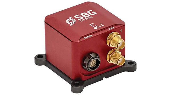
OEM
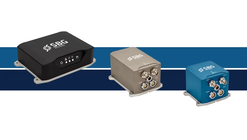
INS With three additional GNSS receiver variants
Photo: Topcon
SBG Systems has upgraded its inertial navigation systems — Ekinox, Apogee and Navsight — with new GNSS receiver options. The latest update introduces three additional GNSS receiver variants.
These include:
Marinestar, which supports Fugro Marinestar, delivering precise point positioning (PPP) with centimeter-level accuracy via L-band corrections without requiring a base station. It is optimized for marine applications.
HAS Ready / NavIC, which includes Galileo E6 support for the upcoming Galileo High Accuracy Service (HAS), offering free decimeter-level PPP corrections globally. Additionally, it supports the Indian NavIC system.
Centimeter-Level Augmentation Service, which is tailored for users in Japan; this variant utilizes QZSS L6 signals to provide free PPP corrections without external services.
All GNSS variants integrate seamlessly with SBG Systems’ antenna portfolio and Qinertia post-processing software. Users select the appropriate GNSS variant at purchase to match their operational requirements. These enhancements aim to provide versatile solutions across diverse industries while ensuring reliable performance.
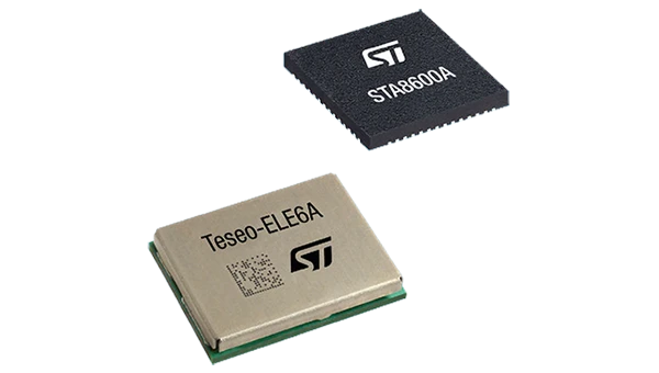
The GNSS receivers in the Teseo VI family use multi-constellation and quad-band signal processing on a single chip, achieving centimeter-level accuracy for various applications. The Teseo VI family includes the STA8600A and STA8610A models. These receivers are designed for automotive applications such as advanced driver assistance systems and autonomous driving, as well as industrial uses, including asset tracking, mobile robots and precision agriculture.
The Teseo VI+ variant can host enhanced positioning engines developed by third-party companies, providing real-time kinematics for centimeter position accuracy.
The LG680P is a multi-constellation, quad-band GNSS module designed for high-precision positioning and to enhance signal quality and precision through concurrent reception of L1, L2 and L5 frequency bands. It supports Galileo E6, QZSS L6 and BDS B2b signals for precise point positioning, ensuring horizontal accuracy of up to 0.8 cm + 1 ppm without requiring local or broadband connectivity.
To ensure signal integrity in environments with electromagnetic interference, the module features professional-grade anti-jamming technology, including built-in NIC algorithms that suppress narrow-band interference. It supports external active antennas for enhanced signal reception and positioning accuracy. It is ideal for applications such as autonomous lawnmowers, delivery robots, surveying equipment and precision agriculture. Quectel complements it with two external GNSS antennas: the YEGR001W8AH geodetic antenna and the YEGD006U1A compact patch antenna.
The New Ellipse firmware upgrade for the Ellipse product line allows the system to now be used as an attitude and heading reference system or inertial navigation system. It is designed to enhance navigation, attitude and heave performance for stable and accurate positioning, even in challenging conditions.
It introduces advanced GNSS-denied capabilities, featuring newly integrated flags that trigger when GNSS jamming or spoofing threats are detected. This allows users to reject or re-enable external sensors — such as GNSS — without resetting the filter. The user-friendly interface allows for fast and flexible configuration using simple command lines, enabling users to tailor the Ellipse to their specific needs and applications.
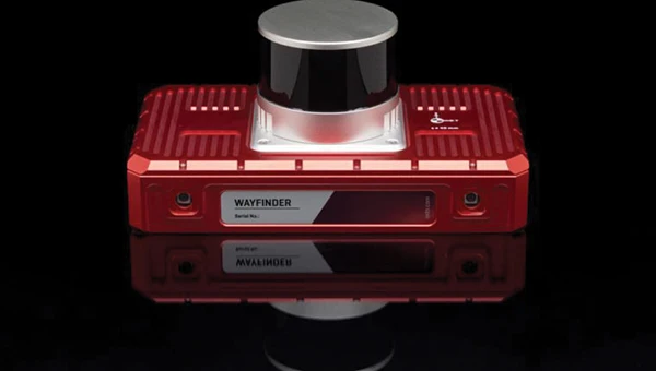
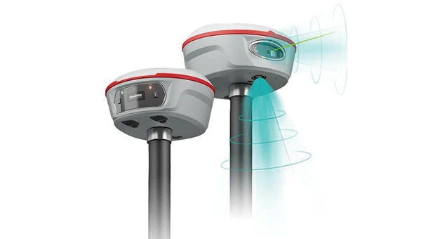
Localization Solution Operates in GNSS-denied environments
Photo: OxTS
WayFinder is a localization solution designed for GNSS-denied environments. It integrates a GNSS/INS system, onboard processor, lidar scanner and two cameras, enabling precise navigation in areas with limited satellite coverage. The system features Lidar Boost, a software technology that enhances GNSS/INS performance by processing lidar data to compensate for missing or inaccurate GNSS updates in real time. This ensures high-accuracy localization and seamless transitions between GNSS-supported and GNSS-denied environments.
WayFinder enables precise navigation for autonomous vehicles in ports, mining and indoor automotive testing without fixed infrastructure. It also provides reliable positioning for surveyors in areas with limited GNSS coverage.
Virtual Surveyor Version 10 introduces Basic Topographic Design tools, allowing users to document terrain changes such as graded roads, water ponds and building surfaces. The software now features four subscription plans — Valley, Ridge, Mountain and Peak.
Ridge plan: Focuses on surveying a single moment in time using one drone data set.
Mountain plan: Adds Timelines to compare surveys across different times, visualizing changes through Time Steps.
Peak plan: Includes advanced Topographic Design tools for planning future structures by creating new Time Steps. These tools allow users to design features such as roads or ponds directly on UAV-derived models, with automated alignment and volume calculations for cut-and-fill operations.
Version 10 introduces drawing guides, available in the Ridge plan and above, enabling precise drawing of points at specific intervals or angles. Walk Mode, included in all plans, allows users to explore 3D terrain at ground level for better visualization. Timelines, featured in the Mountain and Peak plans, facilitate the comparison of multiple surveys conducted at different times and the integration of future designs. These improvements seek to streamline processes for engineering surveyors, supporting applications in construction, mining and water management.
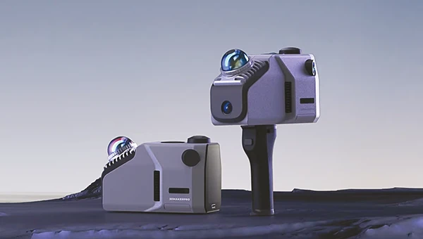
The Jupiter Laser RTK integrates GNSS, auto-IMU, laser and dual camera systems into a single unit. It incorporates a precise green laser that remains visible even in bright daylight. This feature allows for precise measurements of points in hard-to-reach, signal-blocked or potentially hazardous locations. It also features a night vision camera, allowing users to see feature points even in low-light conditions. The RTK system’s laser range is up to 50 m, making it suitable for challenging surveying environments. It incorporates visual technology to offer surveyors an immersive experience during surveying and stakeout operations, improving working efficiency and productivity.
Version 2.1.0 of AgEagle Aerial Systems’ eBee VISION application software introduces circular and grid mapping features, allowing users to generate 2D or 3D maps using external post-processing software for more comprehensive geospatial data.
The eBee VISION 2.1.0 can continue missions in GNSS-denied environments and allows manual deactivation of GNSS to prevent jamming or spoofing. It implements the STANAG 4609 standard, the official format for motion imagery exchange within the NATO nations. This involves embedding UAV position and camera information into the videos recorded by the UAV and those broadcasted by the Ground Control Station. Its inclusion in the system seeks to enhance interoperability with third-party applications, which is key for military-grade UAVs.
It offers enhanced control over the Silent Tactical Landing feature. Users can now manually adjust the landing position on the map, with the system providing range estimates to inform operators of the UAV’s reach. This functionality offers greater flexibility in mission planning and execution, particularly in tactical scenarios requiring precise landing control. The system is ideal for defense, public safety and utilities applications.
‘Drone-in-a-Box’ Solution Designed for vehicle-mounted deployments
Photo: DJI
The DJI Dock 3 “drone-in-a-box” solution is designed for vehicle-mounted deployments and 24/7 remote operations in various environments. This system is compatible with the Matrice 4D and Matrice 4TD UAVs, which feature advanced cameras and IP-rated protection for challenging conditions. The UAVs are ideal for public safety, emergency response and infrastructure inspection.
This system supports flexible deployment options, including vehicle-mounted setups optimized for emergency operations and long-distance inspections. It enables horizontal calibration and cloud-based dock location adjustments. Two docks can be mounted on a single vehicle to facilitate dual-UAV rotations for enhanced efficiency. In fixed deployments, the D-RTK 3 Relay Fixed Deployment Version can be added to improve video transmission and satellite connectivity.
The Matrice 4D and 4TD UAVs have a wide-angle camera, medium tele camera, tele camera and laser range finder. The Matrice 4D features an advanced camera suite designed for high-precision mapping. The Matrice 4TD includes an infrared thermal camera for public safety and emergency response applications. The system includes a Flight Termination System to support regulatory compliance in strictly controlled airspace. This system can manually or automatically stop drone operations if necessary.
Casia G Release 4.0 is a software update that enables nighttime detection of aircraft, allowing 24/7 beyond visual line of sight (BVLOS) UAS operations. The update supports BVLOS flights up to 400 ft at night without requiring hardware modifications, offering detection of both cooperative and non-cooperative aircraft. The system detects aircraft at distances of up to 16.7 km with 360° coverage, ensuring safe nighttime operations. When multiple units are used, triangulation technology provides accurate range, altitude and satellite data for intruding aircraft. The update leverages existing hardware to detect navigation and anti-collision lights at night.
The MAS10 is a 77 GHz FMCW marine radar system designed to enhance navigation safety in congested environments under all weather conditions. The ultra-high-definition W-band radar provides centimeter-level resolution, enabling vessels to detect and identify small hazards in heavily trafficked waterways.
Unlike optical and infrared sensors, W-band radar technology penetrates fog, heavy rain and snow, ensuring reliable detection. It operates effectively in low-visibility scenarios, including complete darkness, intense sunlight and shadowed areas where cameras and lidar may struggle.
The Eagle Series line of spatial 3D scanners feature lidar and imaging sensors and are designed for various applications, including reverse engineering, digital twinning, asset management, extended reality, precision mapping and 3D printing.
The series offers scanning capabilities with a range of up to 140 m and precision within 2 cm at 10 m. The lightweight scanner is designed for portability, with a built-in battery providing up to one hour of continuous use.
The scanners are available in Standard and Max versions. The Max model features four 48 MP cameras, enhancing scanning efficiency and producing vivid 8 K panoramic photos. With a point cloud frequency of 200,000 points per second, the Eagle Series is designed for applications requiring highly detailed spatial data.
Upgraded Mapping Package With Google Maps downloads
Photo: Golden Software
Golden Software has upgraded its Surfer mapping and 3D visualization software. Users can now directly download georeferenced aerial and satellite imagery from Google Maps into projects. The latest version also improves 3D visualization tools, focusing on faster and more intuitive creation of visual models. Users can now colorize 3D drill hole intervals based on text keywords, making it easier to interpret subsurface data. Additionally, contour slices can now be added to the 3D view, offering a clearer representation of data layers.
Golden Software has released a beta version (30.0.135) that introduces multiple light sources for improved 3D viewing and customizable legends for better map presentation. These updates are designed to streamline workflows for professionals in industries such as environmental consulting, resource exploration and geospatial analysis, simplifying the creation of professional-grade maps and models efficiently.
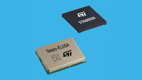
STMicroelectronics has unveiled the Teseo VI family of GNSS receivers. The new receivers integrate multi-constellation and quad-band signal processing on a single chip, achieving centimeter-level accuracy for various applications.
The Teseo VI family includes the STA8600A and STA8610A models, featuring dual independent Arm Cortex-M7 processing cores. These receivers are designed for automotive applications such as advanced driver assistance systems (ADAS) and autonomous driving, as well as industrial uses including asset tracking, mobile robots and precision agriculture.
The receivers integrate all necessary system elements for centimeter accuracy into one die, supporting simultaneous multi-constellation and quad-band operations. This seeks to simplify product development and enhance reliability in challenging conditions, such as urban canyons.
The Teseo VI+ variant can host enhanced positioning engines developed by third-party companies, providing real-time kinematics for centimeter position accuracy. The Teseo APP2 STA9200MA operates dual cores in lockstep, offering hardware redundancy for applications requiring ISO 26262 ASIL-B functional safety compliance12.
STMicroelectronics’ RF architecture and GNSS baseband design provide quad-band GNSS support (L1, L2, L5 and E6) with the ability to acquire and track only L5, improving performance in difficult conditions.
\All variants include hardware cybersecurity features such as secure boot, over-the-air firmware updates, and output-data protection. The devices comply with UNECE R155 and ISO 21434 specifications for cybersecurity by design. Two new GNSS automotive modules, the Teseo-VIC6A and Teseo-ELE6A, have been introduced to simplify integration of Teseo VI/VI+ ICs on customer platforms and ensure optimal performance.
STMicroelectronics has released the ASM330LHB automotive-qualified MEMS inertial-sensing module, which provides accurate measurements for a wide variety of vehicle functions. With the dedicated software provided, ASM330LHB also addresses functional-safety applications up to ASIL B1.
ASM330LHB contains a 3-axis digital accelerometer and 3-axis digital gyroscope that provide a six-channel synchronized output. The module’s high-accuracy inertial measurements are used to improve the precise positioning of a vehicle.
The accelerometer and gyroscope maintain high stability over time and temperature and have very low noise for an overall bias instability of 3°/hour. Specified over the extended temperature range, -40°C to 105°C, the ASM330LHB has multiple operating modes that let designers optimize the data-update rate and power consumption.
ASM330LHB can support advanced driver assistance systems or vehicle-to-everything communication, as well as help stabilize sensing systems such as radar, lidar and cameras, and assist semi-automated driving applications up to L2+. Additionally, ASM330LHB can be used to enable a variety of functionalities in the body of a vehicle.
ASM330LHB was developed with the automotive functional-safety standard ISO 26262 — the ASIL B compatible software library has been certified independently by TÜV SÜD. By implementing dedicated safety mechanisms, including data integrity and accuracy, the library ensures compliance with ASIL B automotive systems.
With the companion software engine, the ASM330LHB supports the growing adoption of automotive systems that require safety integrity up to level B. The combination of two ASM330LHB sensor modules for fail-safe redundancy delivers resilient contextual data for driver-assistance applications such as lane centering, emergency braking, cruise assistance and semi-automated driving.
ASM330LHB is AEC-Q100 qualified and in production now in a 2.5 mm x 3.0 mm 14-lead VFLGA package.
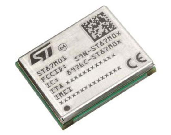
STMicroelectronics has released an ultra-compact, low-power, narrow-band internet of things (NB-IoT) industrial module with GNSS geo-location capabilities, the ST87M01. The fully programmable, certified LTE Cat NB2 NB-IoT industrial module covers worldwide cellular frequency bands and integrates advanced security features.
The ST87M01 is an integrated native GNSS receiver with multi-constellation access, which ensures enhanced and accurate localization. The module has a diminutive 10.6 mm x 12.8 mm land grid array footprint, making it suitable for applications where a small form factor is key.
The STM8701 offers flexibility for product developers, presenting a fully programmable IoT platform enabling users to embed their own code into the module for simple applications. A variety of protocol stacks are available to handle popular IoT use cases.
The ST87M01 targets wide-ranging IoT applications that require ultra-reliable low-power wide-area network connectivity and has ultra-low power consumption with less than 2 µA in low-power mode and transmit output power up to +23 dBm.
Suitable applications for the module include smart metering, smart grid, smart building, smart city and smart infrastructure applications, as well as industrial condition monitoring and factory automation, smart agriculture and environmental monitoring. The module can also be combined with a separate host microcontroller, permitting many more use cases.
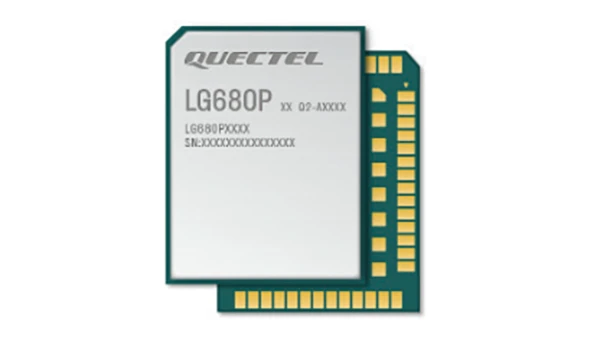
Quectel Wireless Solutions, a supplier of IoT modules and antennas, and Point One Navigation, a provider in precision location technology, have announced the LG69T-AM, the latest addition to the LG69T GNSS Module Series. Point One’s positioning engine powers the LG69T-AM and enables centimeter-level global accuracy by integrating augmented GNSS in a module with open-source API.
The LG69T-AM GNSS module features STMicroelectronics’ Teseo V dual-band L1/L5 positioning receiver platform with 80 tracking and four fast acquisition channels compatible with GPS, GLONASS, Galileo, BeiDou, QZSS and NAVIC.
The LG69T-AM leverages Point One’s RTK and SSR technology for centimeter-level accuracy and ultra-fast convergence time. It is designed for easy integration with minimal e-BOM modification and is well-suited for mass market adoption without the need for an expensive external co-processor. Due to its small package size, light weight, and excellent power consumption, it is ideal for applications such as robotics and precision agriculture.
Embedded in the LG69T-AM is Point One’s FusionEngine and its Polaris correction service client. FusionEngine is compatible with standards-based corrections services including those based on RTCM.
Polaris is Point One’s own GNSS correction service that unlocks better than 10cm absolute accuracy with a coast-to-coast footprint in the United States and coverage across Europe. It offers a variety of connectivity options including delivery over cellular and L-band. The network is purpose-built for precision agriculture customers and includes advanced anti-jam, interference mitigation, end to end security and automatic integrity monitoring unmatched by any other provider.
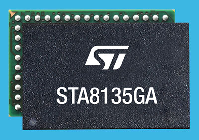
STMicroelectronics has introduced an automotive satellite-navigation chip designed to deliver high-quality position data needed by advanced driving systems.
Joining ST’s Teseo V family, the STA8135GA automotive-qualified GNSS receiver integrates a triple-band positioning measurement engine. It also provides standard multi-band position-velocity-time (PVT) and dead reckoning.
The STA8135GA’s triple-band enables the receiver to efficiently acquire and track the largest number of satellites in multiple constellations simultaneously for superior performance in difficult conditions such as in urban canyons and under tree cover.
Triple band has historically been used in professional applications such as surveying, mapping and precision agriculture that demand millimeter accuracy with minimal reliance on correction data, usually available on larger and more expensive modules than ST’s single-chip STA8135GA.
The compact STA8135GA will help driver-assistance systems make accurate decisions about the road ahead. The multi-constellation receiver delivers raw information for the host system to run any precise-positioning algorithm, such as PPP/RTK (precise point positioning/real-time kinematic). The receiver can track satellites in the GPS, GLONASS, BeiDou, Galileo, QZSS and NAVIC/IRNSS constellations.
The STA8135GA also integrates separate low-dropout voltage regulators on chip to supply the analog circuitry, digital core and input/output transceivers, simplifying selection of the external power supply.
The STA8135GA also enhances the performance of in-dash navigation systems, telematics equipment, smart antennas, V2X communication systems, marine navigation systems, drones, and other vehicles.
“The high precision and single-chip integration delivered by the STA8135GA satellite receiver enables the creation of reliable and affordable navigation systems that enable vehicles to be safer and more context aware,” said Luca Celant, general manager, ADAS, ASIC and Audio Division, Automotive and Discrete Group, STMicroelectronics. “Our unique in-house design resources and processes for high-yield manufacturing are among the critical capabilities that have made this industry-first device possible.”
The STA8135GA is housed in a 7 x 11 x 1.2 BGA package. Samples are available now and full qualification AEC-Q100 and Start Of Production are scheduled for the first quarter of 2022.
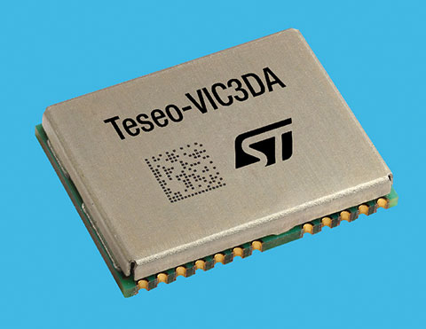
STMicroelectronics has introduced the Teseo-VIC3DA, the latest member of the Teseo module family, designed for vehicle positioning.
Teseo-VIC3DA combines ST’s high-performing Automotive Teseo III GNSS IC with the automotive 6-axis MEMS inertial measurement unit (IMU) and dead reckoning software to create a convenient, automotive-qualified navigation module. The module enables competitively priced in-car navigation, fleet-management, and insurance-monitoring applications.
The automotive Teseo III GNSS IC at the heart of the system is proven in high-end systems and is already highly regarded for its accuracy and efficiency. With multi-constellation awareness, Teseo III offers robust positioning capabilities by simultaneously receiving signals from GPS, Galileo, GLONASS, BeiDou and QZSS constellations.
The ST 6-axis automotive-grade MEMS IC introduces super-high-resolution motion tracking in advanced vehicle navigation and telematics applications.
With the combination of ST’s Teseo III, IMU and dead reckoning, the Teseo-VIC3DA ensures extremely accurate positioning performance in critical environments such as tunnels, beneath structures such as bridges or multi-level highways, in covered areas such as underground parking lots, and in urban canyons between tall buildings.
The Teseo-VIC3DA module operates from 3.3V, helping to simplify system integration, and has a standby mode that draws just 17 µA to minimize demand on the vehicle’s electrical supply. Containing a highly accurate integrated temperature compensated crystal oscillator, the module achieves excellent accuracy of 1.5 m circular error probability for typical automotive use cases. In addition, a dedicated real-time clock oscillator helps ensure fast time to first fix.
Coming with firmware pre-loaded onto built-in flash memory, the Teseo-VIC3DA can be updated with new firmware as necessary using the free Teseo-Suite software. Teseo-VIC3DA can provide up to 30Hz dead-reckoning fix-rate and has very low latency to reduce the UART-channel jitter. Teseo-VIC3DA can autonomously work with and without odometer information.
The Teseo-VIC3DA is tested and certified by ST according to the EU’s Radio Equipment Directive, applicable ETSI standards, and EN safety standards, helping customers achieve mandatory product-level approvals quickly and efficiently. A standalone, USB-powered evaluation platform, EVB-VIC3DA, is available to jump-start development.
The Teseo-VIC3DA is in production now and supplied in a 16 x 12.2 x 2.42 mm 24-pin LCC package.
Autobahn program connects new companies with major brands for investment and development, ST is first semiconductor manufacturer to become Anchor Partner
STMicroelectronics, a global semiconductor company, has become an Anchor Partner of Startup Autobahn, which is powering innovation in the automotive sector by introducing selected dynamic new companies to established technology corporations.
Startup Autobahn is based in Stuttgart, Germany. It was created by and is managed by Plug and Play, a Silicon Valley accelerator and investor that historically has introduced more than 35,000 startups to more than 400 corporations.
Anchor Partners in Startup Autobahn include major car brands and vendors of diverse automotive technologies. ST’s support, with its strategic emphasis on smart mobility, boosts opportunities for new companies with innovative ideas for electrification, e-mobility and smart, connected driving to take part in the program.
“We’re extremely pleased to welcome STMicroelectronics to our platform as a new strategic partner,” said Sascha Karimpour, managing director of Plug and Play Germany. “This partnership fits perfectly into our existing ecosystem, covering the automotive value chain. The semiconductor industry is enabling powerful innovations in automotive technology and will play a major role as software and IT become increasingly important in the car of the future.”
Startup Autobahn organizes events throughout the year to bring corporate partners and selected startups together. The diverse platforms include deep-dive presentations, one-to-one introductions, cross-collaboration days, and private meetings between partners and shortlisted startups. Twice-yearly expos showcase the results of collaborations, combined with keynote speeches and presentations from various industry leaders and invited guests.
The program has already successfully connected startups with established brands to activate powerful new concepts in areas such as battery charging, supply-chain and materials management, smart mobility, efficient manufacturing, recycling and enterprise CO2 reduction.
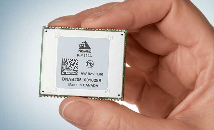
Hexagon | NovAtel has introduced the PIM222A, part of a new family of automotive GNSS positioning products for advanced driver assistance systems (ADAS) and autonomy. The PIM222A harnesses NovAtel’s decades of experience delivering precise positioning in demanding applications for mass deployment in ADAS applications and autonomous vehicles.
Built with automotive-qualified hardware in a package that is easy to integrate, the PIM222A leverages SPAN technology from NovAtel to provide accurate position data in urban environments that challenge GNSS availability. Deeply-coupled GNSS receivers and inertial measurement units (IMUs) ensure continuous availability of position, velocity and attitude, even when satellite signals are briefly blocked.
“I’m excited to introduce the PIM222A, truly the best of both worlds for high-performance GNSS and automotive standards,” said Gordon Heidinger, Segment Manager for Automotive and Safety Critical Systems. “It helps our customers jump-start their development activity for high-precision GNSS, fully supporting performance for all levels of autonomy, ADAS and positioning needs.”
The PIM222A, which was created in collaboration with STMicroelectronics, is a lightweight, power-efficient, solder-down module that maximizes flexibility for integration. The receiver design can be applied to low-, medium- and high-production volumes while retaining a rich array of features, including options such as multi-frequency, multi-constellation, RTK and dual-antenna precision.
The degree of slow-speed and initialization performance is maximized with the dual antenna feature, enabling the best possible positioning performance in all ADAS and autonomous driving situations.
Development kits for the PIM222A are available now for integrators in need of a positioning essentials solution for low- to high-quantity applications.
Agreement focuses on increasing development and capacity for ultra-compact, low-power laser-beam scanners to expand the market
STMicroelectronics and OQmented, a startup focused on MEMS-mirror technology, have agreed to collaborate on the advancement of the technology for augmented reality and 3D-sensing markets. Micro-electro-mechanical systems (MEMS) combine tiny 3D mechanical structures and electrical circuits on a chip to sense and actuate activity.
The joint effort aims to build on the expertise of both companies to advance the technology and products behind the leading MEMS-mirror-based laser-beam scanning solutions in the market.
ST manufactures MEMS sensors, actuators and related components including drivers, controllers and laser-diode drivers. ST is contributing its MEMS design and manufacturing resources to the collaboration.
OQmented plans to further industrialize and mass produce its Bubble MEMS technology, a patented 3D glass-encapsulation method of hermetic vacuum sealing of MEMS micro-mirrors. The glass bubbles eliminate environmental contaminants and minimize light-refraction effects.
Automotive grade. Vacuum sealing is a key element for meeting automotive-grade requirements, while simultaneously reducing power consumption by an order of magnitude and enhancing performance for resonant, bi-axial scanners, where the MEMS mirrors move in both axes at their resonant frequency, creating an ultra-compact and power-efficient scanning solution. The resonant mirrors are suitable for display and 3D sensing applications in mobile devices.
“In teaming with ST, we’ve chosen a solid semiconductor partner that has demonstrated its leading position in design and manufacturing of MEMS products, particularly MEMS mirrors, over the past 20 years,” said Ulrich Hofmann, CEO/CTO and co-founder, OQmented. “Combining ST’s expertise in developing, marketing, and manufacturing key components for laser-beam scanning solutions with OQmented’s knowledge and intellectual property will contribute greatly to our product offering, manufacturing capacity, and marketing channels, while also expanding the market in numerous application areas.”
“Our goal in working with OQmented is to leverage our shared expertise and deep understanding of laser-beam scanning technologies with the mutual vision to continue the adoption and growth of laser-beam scanning in key applications, such as augmented reality and 3D sensing,” said Anton Hofmeister, vice president and general manager, MEMS Microactuator Division, STMicroelectronics.
From the joint effort, ST and OQmented plan to market a wide range of scanning solutions. These would include MEMS mirrors, MEMS drivers and controllers, and complete reference designs of laser-beam scanning engines for a range of applications. The companies also intend to collaborate on a laser-beam scanning roadmap and the development of future technologies and products.
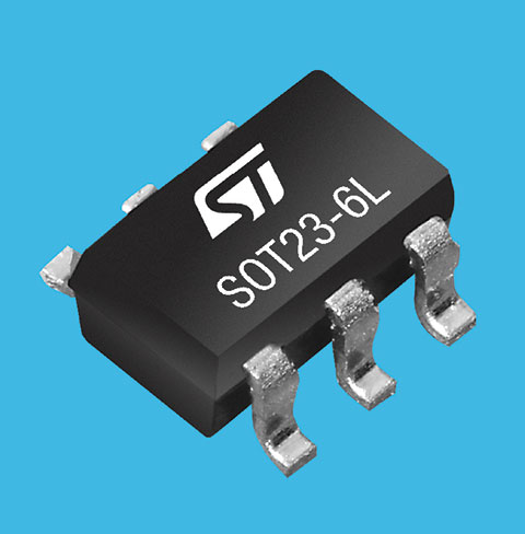
STMicroelectronics’ latest RF front-end for GNSS receivers offers a simplified design and smaller footprint. The BPF8089-01SC6 integrates the impedance-matching and electrostatic discharge (ESD) protection circuitry typically implemented using discrete components.
The BPF8089-01SC6 provides a 50-ohm matched interface between the receiver’s antenna and low-noise amplifier (LNA), and is ready for plug-and-play with the company’s STA8089 and STA8090 LNAs.
The BPF8089-01SC6 is suitable for use in portable receivers for the GPS, Galileo, GLONASS, BeiDou and QZSS constellations, which can be used in applications such as consumer satellite navigation, radio base stations, drones and tracking of assets or livestock.
The BPF8089-01SC6’s compact, integrated front-end can replace a matching network containing up to five capacitors, resistors and inductors, as well as two discrete protection devices, resulting in a much smaller footprint. Designers can also leverage PCB-track specifications provided in the device datasheet to ease design challenges and ensure optimal performance.
The ESD protection provided complies with IEC 61000-4-2 (C = 150 pF, R = 330 ohm) and exceeds level 4: 8 kV for contact discharge and 15 kV for air discharge. The device also withstands 2 kV pulse voltage in accordance with MIL-STD 883 C (C = 100 pF, R = 1.5k ohm).
Part of ST’s Application Specific Integrated Passives (ASIP) product range, the BPF8089-01SC6 is housed in a SOT23-6L package compatible with automatic optical inspection.