AgEagle will acquire senseFly, a Parrot Group subsidiary, for US$23 million.
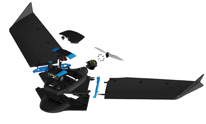
AgEagle Aerial Systems Inc. is a a provider of drones, sensors and software, and Parrot is a European drone company. Founded in 2009, senseFly develops and produces a proprietary line of eBee-branded, high performance, fixed wing drones for professional use.
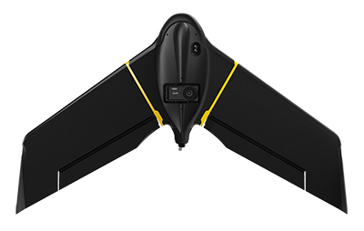
The eBee Geo drone was introduced in March. (Photo: SenseFly)
The development positions AgEagle to provide a full-stack fixed-wing drone solution for agriculture, government, engineering and construction, among other industry verticals. SenseFly also brings to AgEagle solid engineering talent focused on advanced research and development, a well-established global reseller network, and a strong portfolio of intellectual property, AgEagle stated in a press release.
The eBee drones are designed to be safe, ultra-light and easy to use. They are in use by thousands of customers around the world in agriculture, government, engineering and construction to collect aerial data. Headquartered in Lausanne, Switzerland, senseFly employs 90 people, generating total annual revenues of US$12.5 million in 2020.
“Recognized as the producer of the world’s most widely used fixed wing drones, senseFly is an ideal strategic fit for AgEagle,” said Brandon Torres Declet, chief executive officer of AgEagle.
Moving forward, Parrot will focus its expertise and resources on the growth of its professional quadcopter drone equipment and drone data analysis software activities, according to Parrot founder and CEO Henri Seydoux. “The transaction will provide additional cash and lower operational expends to drive Parrot’s growth and industry standing,” Seydoux said. “With the capabilities of the ANAFI line of professional drones and of the Pix4D software suites, Parrot will continue to address its core market segments: 3D mapping, surveying and inspection, agriculture, and defense and security.”
In tandem with the closing of the acquisition, which is expected shortly, Labossiere will resign as CEO of senseFly. Michael O’Sullivan, who previously served as the company’s head of global marketing, will be appointed managing director of the new AgEagle subsidiary. All other senseFly employees will retain their current responsibilities.
For details relating to the terms and conditions of the acquisition, refer to the Form 8-K to be filed by AgEagle with the U.S. Securities and Exchange Commission upon closing of the transaction and accessible at www.sec.gov.
The National Civil Aviation Agency (ANAC) of Brazil has approved beyond-visual-line-of-sight (BVLOS) flights using SenseFly‘s flagship eBee X fixed-wing drone.
ANAC’s decision means that the senseFly eBee X is officially approved for use in future BVLOS missions carried out by Brazilian drone operators. The drone received approval by demonstrating the safety requirements of the ANAC RBAC-E 94 Regulation for Unmanned Aircraft, through detailed engineering analyses and in-depth flight testing. Sensefly worked in collaboration with drone engineering and consulting specialists AL Drones and geotechnology company Santiago & Cintra.
Following the certification, senseFly eBee X operators in Brazil now only require a CAER (Special Airworthiness Certificate for RPA) waiver for the aircraft with Santiago & Cintra before flying BVLOS operations.
“The commercial drone industry in Brazil has been growing at a phenomenal rate. and we’re excited that the senseFly eBee X is at the forefront of these regulatory developments,” said Pierre-Alain Marchand, regulatory compliance manager, senseFly. “BVLOS is becoming an important tool for operators as they start to explore the potential of more advanced drone operations, and we’re pleased that our technology continues to help define frameworks and legislation in the country. Historic approvals passed in recent years has shown us that Brazil is one of the countries to watch for drone commercialization, so continue to watch this space!”
The authorization comes following approval of senseFly’s proprietary drone technology in 2017, where the use of drones for civil applications in Brazil were legislated as part of the RBAC-E94 regulation. SenseFly drones became the first and only in the country permitted to fly 400 feet in height with a 5 kilometer radius from a licensed pilot or observer, in contrast to previous VLOS operations that restricted use of drones to a 500-meter radius.
“The authorization of senseFly’s eBee X for BVLOS operations is another step towards commercialization of the sector,” said André Arruda, co-founder of AL Drones. “After years of collective hard work and effort from all parties, this certification presents a real opportunity for operators in the future to expand their mapping operations and achieve a robust return-on-investment. We look forward to seeing what this means for BVLOS operations in Brazil in the coming years.”
SenseFly’s eBee X fixed-wing drone is designed to suit a wide range of mapping jobs. At 1.6 kg (3.5 lbs.), eBee X is a lightweight, portable solution that is easy for a single person to operate. With an Endurance Extension option enabling a flight time of up to 90 minutes and single-flight coverage of up to 500 ha at 122 m (1,236 A at 400 ft.), the eBee X drone that offers users the high precision of on-demand RTK/PPK for achieving absolute accuracy down to 1.5 cm (0.6 in) without ground control points. This capability makes the eBee X suitable for BVLOS operations such as long corridor mapping missions for utility companies, expansive crop scouting in agriculture and by enterprise customers who desire a robust and professional drone fleet.
A roundup of recent products in the GNSS and inertial positioning industry from the April 2021 issue of GPS World magazine.
OEM
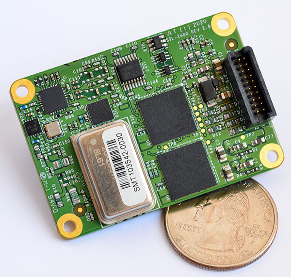
STL receiver
For Satellite Timing and Location service
Photo: JLT
The STL-2600 Satellite Timing and Location (STL) commercial receiver was designed in partnership with Satelles Inc., the STL service provider. The STL-2600 provides a GNSS-independent, low-cost capability to generate UTC nanosecond timing and meters-accurate positioning anywhere in the world. The STL signal has 30-db (1,000 times) higher power compared to GPS signals, allowing the receiver to operate deep indoors independent of any GPS/GNSS signal. It is also useful in marine applications where GNSS signals are regularly denied or manipulated and for stationary high-accuracy timing applications such as 5G. It can be directly connected to JLT’s GPS Transcoder products for glueless retrofit capability of existing customer legacy GPS-only receiver systems to Galileo, GLONASS, BeiDou, QZSS and SBAS as well as adding the STL and optional atomic holdover capability to these legacy systems.
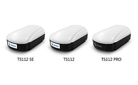
The TS112 family of smart antennas is designed for demanding applications such as agricultural machine autosteering systems that require high positioning accuracy. They offer scalable positioning solutions with increased GNSS availability, reliability and accuracy. Each of the three models embeds Harxon X-Survey four-in-one technology. The high-gain and wide beamwidth multi-constellation GNSS antennas integrate 4G, Bluetooth and Wi-Fi in a compact unit. They feature multi-point feeding technology, ensuring high phase-center stability and real-time kinematic (RTK) centimeter-level positioning accuracy. They integrate a high-precision GNSS module with multi-band GNSS receiver and Harxon’s four-in-one multifunctional GNSS antenna in a compact housing.
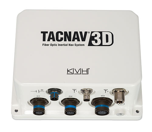
The TACNAV 3D tactical navigation system is now available with the P-1775 inertial measurement unit (IMU) featuring KVH’s new photonic integrated chip (PIC) technology. PIC technology features an integrated planar optical chip that replaces individual fiber-optic components to simplify production while maintaining or improving accuracy and performance. KVH’s IMUs with PIC technology are designed to deliver improved bias stability and greater accuracy. The fiber-optic gyro (FOG)-based TACNAV 3D tactical navigation system provides an assured positioning, navigation and timing (A-PNT) solution with an embedded GNSS and optional chip-scale atomic clock (CSAC).
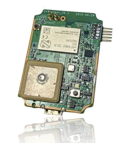
IoTeX has selected Nordic Semiconductor’s nRF9160 low-power System-in-Package (SiP) with integrated LTE-M/NB-IoT modem and GPS receiver to provide the cellular internet of things (IoT) connectivity for its Pebble Tracker. The Pebble Tracker provides trusted location, environment and motion-tracking data for global asset tracking and industrial supply chain applications. Critical features strengthen security from hacking and data corruption, meeting the demand of applications that require strong data security and integrity protection throughout the supply chain. There are two versions of Pebble Tracker. The first targets blockchain and IoT developers, while a second commercial version is designed for the asset tracking and industrial supply chain markets. The product combines an environmental sensor, a motion sensor (gyroscope and accelerometer), and an ambient light sensor. It enables cellular network connectivity and integrated GPS support in a global version supporting precise, long-range tracking of asset data using established cellular infrastructure.
Enables transmission of corrections via the internet
Emlid Caster is an easy way to transmit corrections between real-time kinematic (RTK)-capable devices via the internet. Emlid Caster has a simple interface. Users can create their personal mount point and connect one base and up to five rovers. It works not only with Emlid products but any other device supporting NTRIP. For example, users can pass RTK corrections to the DJI Phantom 4 RTK drone from the Reach RS2 receiver as a base station. Emlid Caster is free and available worldwide. Once signed up, personal NTRIP credentials are generated automatically for a base and a rover.
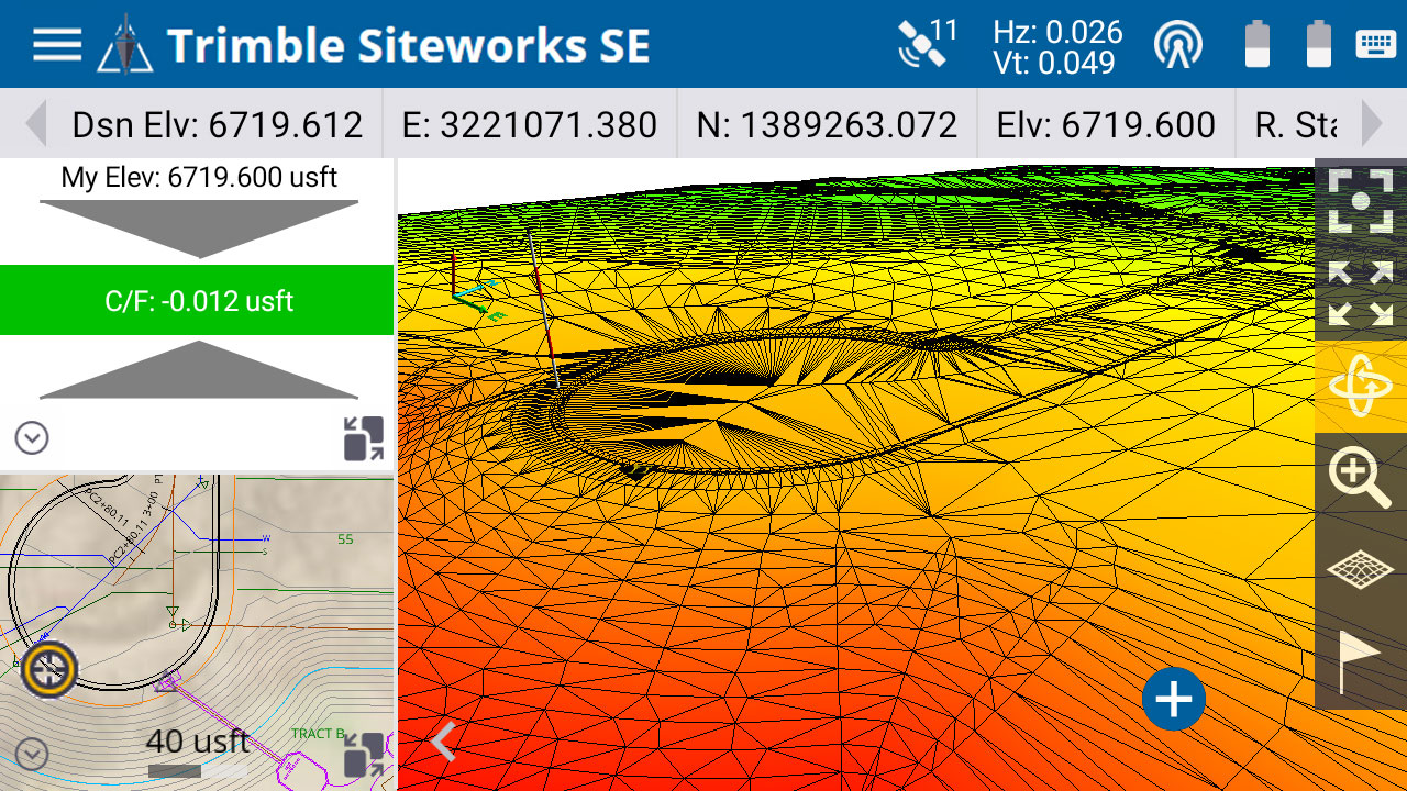
The Trimble Siteworks SE Starter Edition. (Screenshot: Trimble)
The Trimble Siteworks SE Starter Edition is an entry-level construction surveying software program. With the program and a construction GNSS receiver, a supervisor, foreman, grade checker or site engineer can easily check a grade, slope or alignment and navigate the project more accurately and in less time than with traditional survey methods. It also can give more personnel on the jobsite access to survey technology, enabling more productive and efficient field crews. Trimble Siteworks SE Software is a simplified version of Trimble Siteworks Software, intended for users who do not require a full feature set and are interested in a lower-cost version to connect to GNSS only. Contractors can easily upgrade to the full version.
The Leica CityMapper-2L configuration is designed for airborne urban mapping projects at low altitude operation. Lower flying heights can be required by air traffic control (ATC) restrictions and in areas with low cloud cover. It features a 71-mm focal length at nadir, suitable for 5-cm ground sample distance (GSD) data acquisition at flying heights of 940-m above ground level. The new lenses offer similar coverage and productivity for a specific GSD as existing configurations for standard and high-flying heights, while significantly expanding the operation envelope. The CityMapper-2 hybrid airborne sensor combines oblique imaging and a lidar in one system. The sensor efficiently creates digital twins of cities. The system includes two 150 MP nadir cameras (RGB and NIR), four 150 MP oblique cameras and a 2-MHz linear-mode lidar sensor.
Full-waveform flash data for autonomous vehicle development
Photo: LeddarTech
Leddar PixSet is a publicly available sensor dataset for advanced driver assistance and autonomous driving research and development. The dataset includes full-waveform data from LeddarTech’s Leddar Pixell, a 3D solid-state flash lidar sensor. LeddarTech is offering these datasets free of charge for academic and research purposes. It allows academic and engineering research teams specializing in advanced driver-assistance systems (ADAS) and autonomous driving technology to use existing sets of sensor data to test and develop advanced software and to run simulations without having to assemble new sensor suites and collect their own dataset. An instrumented vehicle was utilized in the development of the dataset. The various scenes were recorded in high-density urban and suburban environments as well as on the highway.
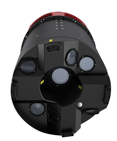
The mdLiDAR1000HR aaS drone lidar survey package is designed for professionals responsible for geospatial data collection, such as corridor mapping, mining (volume calculation), construction site monitoring, recording environmental changes over time, forestry, contour mapping, archaeology and cultural heritage, and more. The drone lidar system has a 90° field of view for both scanned points and imagery. It repeatedly provides a precision of 1.6 cm (.052 feet) when flown at 40 m (130 ft) at a speed of 8 m/s (18 mph). It integrates the Velodyne Puck Lite lidar sensor.
The fixed-wing eBee Ag drone can provide a complete assessment of a farm and crops faster than traditional field scouting. With its dual-purpose Duet M camera, eBee Ag captures accurate RGB and multispectral data that enable farmers to effectively assess crop health and help catch early indicators of pests, diseases and weed infestations that threaten crop yields. It features real-time kinematic (RTK) functionality for greater mapping precision. With its available RTK, the drone can achieve absolute accuracy down to 2.5 cm (1.0 inches) with RGB. Highly accurate index maps allow farmers to understand each acre while managing problematic areas field-wide.
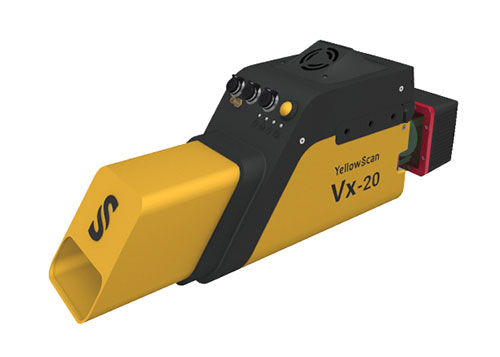
The Vx15-300 and Vx20-300 UAV lidar solutions are new additions to Yellowscan’s Vx product series. A new terrain software module allows users to automatically classify grounds from off-ground, as well as export various digital elevation models. Both integrate the Riegl Mini-VUX 3 airborne laser scanner (1.55 kg / 3.4 lbs), designed specifically for integration with UAVs. The scanner offers a selectable 100-kHz, 200-kHz and 300-kHz laser-pulse repetition rate (PRR). At 300-kHz PRR, the sensor provides up to 100,000 measurements per second at 120° field of view, and thus a dense point pattern on the ground for UAV-based applications that require the acquisition of small objects.
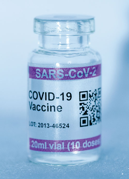
Cryo-Vacc containers use helium — a fraction of the weight of nitrogen — to provide safe transportation of vaccines at the required extremely low temperatures and for periods of up to 30 days, without the need for any power supply. Now in prototype, the containers work with both air and ground transportation. A temperature range of -150°C to 8°C, makes it versatile for a range of vaccines — including those for COVID-19 — that need to be transported for up to 25 days or longer in transit, where access to an external power source is not possible. Combined with cold-chain monitoring and asset tracking technology from Beyond Wireless (a World Health Organization-certified provider), Cryo-Vacc can provide accurate temperature readings of vaccines in transit, as well as GPS-based tracking to ensure the custody chain can be audited.
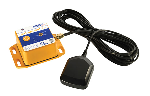
The tamper-proof MSR175plus GPS data logger records potentially damaging shock events as well as the associated ambient conditions with the exact geographic position via its GPS/GNSS receiver. It contains two 3-axis-acceleration sensors (±15 g/±200 g), a temperature sensor (-20 to +65° C), a humidity sensor (0 to 100% relative humidity), air pressure sensing (0 to 2000 mbar), and an ambient light sensor (0 to 65,000 lux). It helps ensure compliance with transport specifications and provides irrefutable data for identifying damage liability for help with insurance claims. An external connector is ready for a cable-connected antenna. The removable, rechargeable 2400 mAh LiPo-battery enables recording for up to 8 weeks (at least one year without GPS-based tracking).
Why permissions and regulations are an important part of workflows
By Pierre-Alain Marchand Regulatory Compliance Manager, senseFly
Pierre Alain Marchand
Now widely accepted as a mainstream commercial mapping tool, the benefits of using drones to make better-informed decisions and provide a robust return on investment are well understood.
But progress in drone technology is shifting the focus to more advanced operations, a term that encompasses a wide range of activity, including beyond-visual-line-of-sight (BVLOS) flights and operations over people (OOP), as well as flying at night, as part of a fleet, or in restricted airspace.
These types of flights typically require more planning and permissions, but both can help improve safety for people on the ground, as well as create long-term cost savings and improve data-collection efficiencies.
Part 107 Waivers. However, while the benefits of advanced drone operations are increasingly well recognized, navigating these differences can be complex.
For instance, the Federal Aviation Administration (FAA) requires all companies planning advanced drone operations to complete a Part 107 waiver, an official document that approves certain operations of aircraft outside the limitations of regulation.
However, of the thousands of applications completed in 2018, only 23 were approved. Despite these poor figures, progress is being made to help make the approvals process more accessible.
Testing. Drone testing has been key to getting operations to where they are today — and will continue to play a role when demonstrating how the required safety, regulatory and logistical criteria of advanced drone operations can be met. Its importance should not be underestimated; testing has the potential to speed up regulatory procedures and even expand drone operations.
For that reason, investing in drone testing remains a priority today — the more data that is made available to backup a drone’s durability and reliability, the more evidence there is that the technology is safe and fit-for-purpose. SenseFly fixed-wing drones, for example, have thousands of hours of safety testing behind them, which is vital for streamlining and accelerating the approval of waiver requests and flight permissions.
Testing can also create more opportunities within the project scope, for instance by allowing operators to fly in more built-up areas.
Permissions. Although testing plays a key role in establishing regulatory compliance, it is still only one piece of the puzzle. With the rules for flying changing all the time, there is also the issue of navigating complex flight permission processes, which vary between countries.
The good news is that we are now seeing authorities across the world taking measures to streamline the regulatory process and make the rules clearer for operators. For example, the FAA has recently launched its new BEYOND program, which will support efforts to move toward BVLOS operations being carried out under established rules rather than waivers. Type certification is also becoming increasingly important in the U.S., which may further signal a potential move away from waivers in the future.
It’s promising to see the issue of regulatory compliance and flight permissions being placed at the top of authorities’ agendas. Connections are vital. Working in this way is a two-way process: both parties want to learn more about advanced drone operations and streamline the administration requirements.
Although there is still work to be done to ensure advanced drone operations become more accessible, the industry is moving in the right direction. As the approval process becomes easier, we predict more commercial companies will see the value of these operations and begin implementing them in their workflows.
Pierre-Alain Marchand is a regulatory compliance manager at senseFly , a commercial drone subsidiary of Parrot Group. For more information, visit the website or contact Marchand at [email protected].
Photo: Joel Papalini/iStock / Getty Images Plus/Getty Images
Airports are extremely congested spaces, both on land and in the air, making it difficult to conduct surveys that provide insights into their continued monitoring and maintenance.
UAVs create the opportunity to survey such sites safer and faster, reducing disturbances to everyday operations while collecting a level of detail unparalleled by conventional surveying techniques to locate and accurately capture areas in need of maintenance and management on airport runways.
Following several drainage and grading issues throughout a 650-acre airport, Texas-based civil engineering company Gessner Engineering was contracted to provide surveying services to identify the most problematic regions.
The team had to conduct the survey with minimal impact on runway operations. By coordinating with the airport’s air traffic controllers, the team planned a 6–8-hour flight window, with just a few pauses for ongoing traffic, while the airport operated as usual.
Before the flight, the surveyors used senseFly eMotion flight-planning software to carry out pre-flight risk assessments and plan flights. During the survey, four 20-minute flights were completed with the senseFly eBee fixed-wing drone. With its fully autonomous and easy-to-use aerial mapping capabilities, the eBee was able to capture the high-resolution aerial photos needed to map the entire airport. The data was processed using Pix4D Mapper to generate a topographic model including a point cloud with a ground sample distance of 1.5 inches.
The point cloud was so comprehensive, it brought attention to four more areas with drainage issues, providing a level of detail that would not have been possible using only a ground GNSS base station. The UAV survey took one day, compared to four weeks for traditional surveying. This cut the project time in half and significantly reduced disturbances to airport operations.
“The savings in manpower with the shorter surveying time, accurate data retrieved, and the additional drainage issues identified demonstrate the value of drones, as an enabler of solving complex challenges in congested airspaces, especially where time is limited,” said Troy Hittle, general manager, North America, SenseFly. “The success of this project by using UAV equipment has offered new possibilities to both Gessner Engineering and the future of aviation maintenance.”
SenseFly, a drone solutions provider, will be demonstrating its drone solutions at Intergeo 2019, which will take place Sept. 17-19 in Stuttgart, Germany.
According to the company, visitors to its booth will be able to explore the flexibility of senseFly’s eBee X drone and its role in optimizing GIS and surveying workflows to achieve high quality outputs, such as centimeter-precise 3D point clouds, orthomosaics and digital surface models.
Attendees will be able to learn about the range of payloads and software solutions the eBee X platform can be used with, including the senseFly Aeria X, senseFly Duet T, senseFly S.O.D.A., senseFly S.O.D.A. 3D, MicaSense RedEdge-MX and Parrot Sequoia.
The senseFly team will also be hosting a series of Meet the Experts sessions on-stand featuring guest speakers and demos from senseFly partners such as Pix4D, ALLNAV and Harxon. The 10-minute talks will be followed by Q&A sessions.
“Our expert team also enables us to deliver the knowledge and insight our users need to navigate the changing landscape as drone technology continues to garner greater public and legislative attention worldwide,” said Gilles Labossière, CEO of senseFly. “Our customers’ needs are constantly evolving, and it’s vital for us to ensure that our products and solutions are as dynamic and versatile as they are to meet their unique and complex challenges.”
SenseFly’s can be found at booth B3.078, Hall 3, at Intergeo 2019.
The new senseFly Solar 360 UAV is designed to enable the automated and efficient inspection of solar farms.
Photo: SenseFly
SenseFly has introduced its senseFly Solar 360. Created in collaboration with software company Raptor Maps, the offering is an efficient thermal drone solution that enables the automatic assessment of solar plant performance at a sub-module level, the companies said.
Created by combining eBee X fixed-wing drone technology, senseFly’s Duet T thermal mapping camera and Raptor Maps’ software, senseFly Solar 360 is a fast and fully automated drone. It is easily integrated into solar management workflows without requiring either drone piloting skills or the manual analysis of aerial solar farm data.
“At senseFly we are continually looking across the industry to identify new commercial partners with whom we can bring to market what our customers need, which is vertically-focused end-to-end solutions,” said Gilles Labossière, CEO of senseFly.
“With Raptor Maps, we are collaborating with a true solar industry pioneer,” Labossière said. “Their software takes the guesswork out of solar farm inspection and, crucially, speeds up this process — from days down to hours. This efficiency, combined with the eBee X’s large coverage and reliability, ensures that farm owners and operators — or the drone service providers they employ — can inspect utility-scale solar farms more quickly, easily, and accurately than ever before.”
“Solar power is the largest source of new energy generation in the world,” said Nikhil Vadhavkar, CEO of Raptor Maps. “This rapid growth has fueled demand for industry-specific solutions to allow solar customers to scale. Our enterprise-grade software has been deployed across six continents and 25 million solar panels to increase power production and reduce risk and maintenance cost across solar portfolios. We are proud to collaborate with senseFly, the industry leaders in commercial fixed-wing drones, to increase access to Raptor Maps while providing a comprehensive, end-to-end solution that scales with the solar industry.”
SimActive Inc., a developer of photogrammetry software, announced that Correlator3D is being used for mapping projects in Brittany, France, by Altimedias.
An eBee X equipped with senseFly S.O.D.A. 3D camera is flown along the shoreline to produce high-resolution true orthomosaics and 3D models.
“The quality of outputs from Correlator3D is exceptional and the mosaic renders the vivid colours of the Pink Granite Coast,” said Didier Wasselin, COO at Altimedias, which specializes in drone data collection and processing. “Such results are very useful for heritage conservation and decision making by local authorities.”
“The combination of SimActive software and senseFly eBee Plus X is an ideal combination, due to the accurate RTK/PPK and optimized aerial triangulation,” said Francois Gervaix, technical advisor at SimActive. “The S.O.D.A. oblique imagery leads to outstanding 3D textured models.”
Special section, October 2018 GPS World. Cover photo: PrecisionHawk
If you blink, you might miss something! The examples here represent only a fraction of this booming field, but they show how diverse drone use has become. Interspersed among them, this article offers further insights on technology integration, the regulatory outlook and the economic future of this fast-moving industry.
By Tony Murfin, Contributing Editor, UAV & Professional OEM
Capturing where the drone industry has been this year and where it is headed in 2019 resembles trying to describe a Florida thunderstorm: how can there be so much rain so quickly, how long will it last, and what will the landscape look like afterwards? (I’m writing this during just such a deluge near Venice on the Gulf Coast.)
The UAV/UAS industry has grown at such an amazing rate, it’s almost impossible to count or describe all the applications that have become normal practice, not to mention the number of companies involved in either making drone platforms or supplying drone integrators with sensors: GNSS, inertial, lidar, cameras photographic, thermal, infrared, video and more.
From accident reporting to crop monitoring to infrastructure inspections, drones are, so to speak, on the rise. This year we have seen substantial increases in investments by equipment suppliers, continuing funding for military businesses, prototype systems for remotely identifying and even taking down drones, and vastly expanded use in mapping and survey.
As precision guidance, autonomous operations, high-definition geocoded images and high-volume data processing all improve, drone usage will continue to increase. OEM receiver manufacturers, sensor suppliers and data-handling companies play key roles in development, and stand to profit thereby.
The Delair Septentrio UX11 mapping UAV. (Image: Septentrio)
In particular, use of drones is growing in land management, construction, mining and farming. An open-pit mine operation can be supported through detailed drone inspection producing high-resolution images. Processed images and data enable keeping tabs on inventory, site changes over time, identifying best areas for further extraction, and monitoring and managing vehicle movement. These tasks required huge amounts of time in the past. Drone overflight and processing tools condense all the effort as well as producing enhanced results to enable faster and clearer decision-making.
Surveillance and reconnaissance are probably the biggest military drone applications. Carrying payloads that include color video cameras and infrared night vision cameras, more than 19,000 drones are now in the arsenal of the U.S. Army, Air Force, Marines and Special Ops, and more have gone to other nations’ militaries. Some fly at relatively low altitude, with limited range and powered by a single quiet electric motor; these drones have become essential in gathering forward-situation intelligence.
The following examples represent only a small part of the industry. I selected them here to show how diverse drone use has become. Interspersed among them, I’ll offer further observations on technology integration, the regulatory outlook and the economic future of this fast-moving industry. If you blink, you might miss something!
Accident Investigations
In the past, when police arrived at a serious traffic accident, investigators had to use tape measures and roller wheels to construct an accurate physical record of the incident. More recently, police have used laser measuring tools but this still entails time-consuming procedures and produces traffic back-ups. Now police departments have started to collect highly accurate aerial images of traffic incidents using drones, and it’s proving quicker and more efficient.
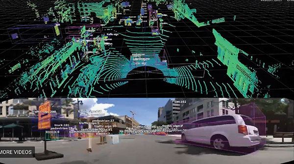
UAVs collect photos and videos, and software then stitches multiple high-resolution images together into a 2D or 3D map. With geolocation annotation provided by the drone, investigators can then take measurements directly from visual accident records.
Previously, an investigation could take up to three hours gathering information manually, but with a drone overflying and documenting an accident this might be reduced to around 45 minutes. This clearly saves time and money for the police as well as drivers who suffer shorter traffic delays. With an investment of about $15,000 in drone hardware and training, payback can happen pretty quickly.
Overall UAV Market Growth
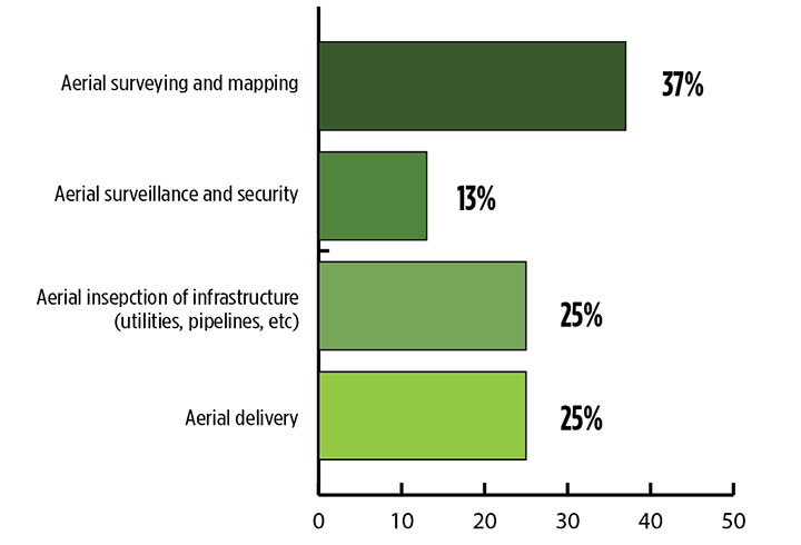
What is the killer app for drones? What professional UAV market sector will most powerfully drive adoption and influence new regulations for unmanned aerial vehicles? (Source: GPS World 2018 State of the GNSS Industry survey)
The drone logistics and transportation market was estimated to be valued at US $11.20 billion in 2022 and is projected to reach $29.06 billion by 2027, at a combined annual growth rate (CAGR) of 21.01%, according to India-based MarketsAndMarkets Research, in its May 2018 report.
The logistics and transportation market was defined to include warehousing, shipping, infrastructure, software, military, freight, and even passenger and ambulance drones. “The increasing use of unmanned aerial vehicles in civil and commercial applications for faster delivery of goods is one of the most significant factors expected to drive the growth of the drone logistics market,” stated the report.
The shipping segment is indeed projected to grow at the highest CAGR, as drones will see increasing use to transport a range of products from small packages to medical supplies and food. Venture capitalist investment in this market has been substantial as well as significant commitments by companies such as Amazon, Google, and Walmart in research and development to commercialize drone delivery services.
Couple that with another report from the same company report on the drone analytics market, valued at $1.17 billion in 2016 and projected to reach $5.41 billion by 2022, at a CAGR of 28.11% from 2017 to 2022. The drone analytics market was considered to encompass agriculture and forestry, construction, insurance, mining, utilities, telecommunications, oil and gas, and scientific research.
Both reports note that “The imposition of restrictions by various government agencies on the use of UAVs in civil and commercial applications is one of the major challenges faced by the drone logistics and transportation market.”
In February of this year, MarketsandMarkets estimated that the overall UAV market was valued at $18.14 billion in 2017 and projected to reach $52.3 billion by 2025, at a CAGR of 14.15%.
Agriculture
Results of a survey of 269 farmers by Munich Reinsurance America indicate that three quarters of all farmers in the U.S.— from those with less than 100 acres to those with more than 5,000 — have either begun to use drones for precision agriculture, and monitoring crops, livestock and soil conditions, or are thinking about using drones. Roughly half of these farmers contract out the work to drone service suppliers and most use drones either daily or more than once a week.
Sensor Integration
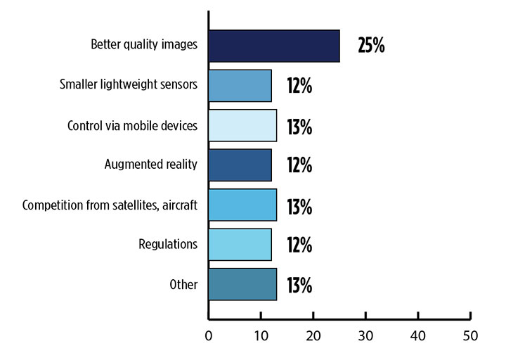
What is the biggest challenge for the UAV industry? (Source: GPS World 2018 State of the GNSS Industry survey)
As the size, weight and power (SWAP) and the accuracy of sensors continue to improve, drone use will continue increasing steadily. OEM receiver manufacturers, sensor suppliers and data-handling companies play key roles in this vital and ongoing development, and stand to profit thereby.
Making it all work is a combination of sensor payloads gathering inertial and GNSS location, stills and video, lidar, thermal and hyperspectral data; the secret sauce lies in how the data is processed and presented to users. All these areas show significant growth. The following are only a few key examples.
Lidar. Light detection and ranging (lidar) detects and measure the distance of an object or surface from an optical source, in this case a hovering or cruising UAV. GPS and inertial provide geo–referencing per each scan point.
Lidar has seen increasing application in surveying and engineering, GIS mapping, accident scene reconstruction, topographic and coastline mapping, digital elevation model and digital surface model generation, mining and quarries, gas and oil pipelines, railroads and other infrastructure. As hardware costs decline, software begins to play more and more of a major role, becoming a larger part of the solution in every way.
The M200 Snoopy series lidar package from LidarUSA is designed specifically for integration aboard the DJI M200 UAV. The laser scanning has a 100-meter maximum range, yielding 4-5 cm accuracy. It carries a tactical grade L1/L2 GPS/IMU unit and weighs 1.63 kg.
Inertial Miniaturization. UAVs are driving even further size-downs of other navigation sensors as well.
As just one example, the miniature μIMU from Inertial Sense incorporates a magnetometer, barometric pressure sensor, and L1 GPS (GNSS) receiver. Angular rate, linear acceleration, magnetic field, barometric altitude, and GPS location outputs are at 1 KHz with UTC time synchronization.
ADS-B.Aerobits in Poland has developed a high-speed, miniaturized (23.0 x 18.0 x 2.5mm & weighing 2 grams) Automatic Dependent Surveillance-Broadcast (ADS-B) module which provides detect-and-avoid for small UAVs. The module accepts external GNSS position inputs and has high speed on-chip processing which enables processing of thousands of ADS-B signals/second from other aircraft/drones. Aerobits claims a reception range of over 200 miles due to a high-sensitivity RF front-end. With FAA-mandated equipage coming for aircraft in 2020, this potentially offers a detect-and-avoid option for even small drones.
Regulatory Outlook
The Association for Unmanned Vehicle Systems International has been an industry voice for more than 40 years. AUVSI president Brian Wynne recently told Congress what needs to be done to fully integrate UAS into the National Airspace System — a critical step in further drone development and growth.
Initial regulations governing civil and commercial UAS operations are now in place. The FAA’s small UAS rule, known as Part 107, established a flexible, risk-based approach to regulating UAS and reduced many barriers to low-risk civil and commercial UAS operations. Since its enactment in 2016, however, demand for commercial UAS has exploded.
“As of March 2018,” Wynne stated, “more than 150,000 platforms have been registered for commercial use. The FAA expects more than 450,000 UAS to be flying for commercial purposes over the next five years.” That’s three times as many as today!
Waivers to Part 107 permit their holders to operate at night, as well as in certain restricted airspaces, beyond line of sight and over people. More than 1,700 operators across the U.S. have received these waivers.
Continued adoption of unmanned flight will require an expanded regulatory framework that extends the waiver provisions much more widely. There are many challenges to this, particularly security concerns. A key step will be “implementing a remote ID system that identifies any UAS flying in the airspace, in real time.” according to Wynne.
The FAA reauthorization bill recently passed by the House of Representatives calls for rulemaking concerning carriage of property, a necessary step for allowing UAS package deliveries — the next big thing.
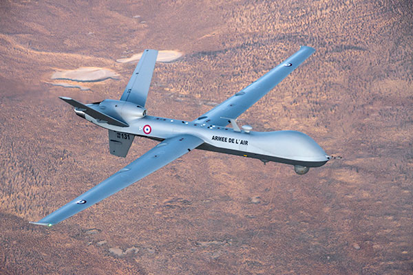
Military UAV Business Strong
French MQ-9 Reaper. (Photo: DoD press release/UAS Vision)
Military business remains a major source of revenue for the UAV/UAS industry, as demonstrated by the recent award of several contracts to various drone suppliers.
U.S. Naval Air Systems Command recently awarded Insitu a ~$54 million fixed-price contract for four production RQ-21A Blackjack unmanned aircraft systems and eight attrition air vehicles: seven for the Marine Corps and one for the government of Poland. The contract includes ground control stations, launch and recovery equipment, shipboard equipment kits as well as systems engineering and program management support.
U.S. Army Contracting Command recently awarded General Atomics Aeronautical System Inc. (GA-ASI) a Grey Eagle engineering support contract worth ~$11m. Work will be undertaken at the GA-ASI facilities in Poway, CA and will run through to Sept 30, 2019.
GA-ASI has also just won an FMS (Foreign Military Sales) contract worth $123 million for MQ-9 Reaper systems for France – deliveries are expected to be completed by May 2020. An FMS contract is normally how a foreign government procures U.S. government military equipment. The foreign government contracts with a U.S. agency, and the U.S. agency awards a back-to-back contract to the U.S. supplier. In this case, the U.S. contracting authority is the Air Force Life Cycle Management Center at Wright-Patterson Air Force Base.
The U.S. Missile Defense Agency has awarded General Atomics Electromagnetic Systems (GA-EMS), San Diego, California, a contract worth up to ~$134 million to develop, integrate, and flight test an advanced sensor into the MQ-9 UAV. The work will be performed in San Diego, California from August 2018 through October 2021 with realistic flight testing scenarios taking place both within the U.S. and elsewhere.
At the end of August, Boeing won the contest for the U.S. Navy’s unmanned refueling tanker with an $805 million contract award. The award covers the development and manufacturing of an initial four air vehicles. The future MQ-25 Stingray will be the first UAV to operate from U.S. aircraft carriers to refuel and extend the range of several combat aircraft.
L3 Technologies has won a U.S. Army $454M contract to build, deliver and support an electro-optical infrared laser designator for the RQ-7Bv2 tactical UAS. The drone mounted payload will help the Army manage battlespace situational awareness, increase UAS survivability and obtain imagery for target/threat detection.
Counter-UAS Systems
DroneShield out of Australia markets a drone detection and mitigation system, known for its DroneGun, a point-and-shoot device able to disrupt multiple RF frequency bands simultaneously (433MHz, 915MHz, 2.4GHz & 5.8GHz), taking out the communication link to a drone operator — and also GNSS signals when so equipped — up to 1km away.
The full DroneSentry detection system integrates a suite of sensors and countermeasures including radar, optical, RF listening, acoustic, thermal and an RF countermeasure transmitter with greater power/range than the portable DroneGun.
Survey and Mapping
SenseFly recently completed work on a three-year construction project in Northern Ireland to build the new A6 highway. A senseFly eBee Plus drone provided detailed aerial coverage and minimize interruptions with road traffic and ongoing quarry operations.
Adopting an integrated aerial approach enabled the construction contractor to quickly obtain detailed, accurate, professional-grade data, and has helped save time and resources. Reducing the time required in the field and proximity to dangerous quarry sites optimized the mapping task
High-Precision Survey Drone. The TRIUMPH-F1 UAV is built around the JAVAD GNSS TRIUMPH-1M receiver, the company’s high-precision geodetic GNSS receiver with 864 channels to track all current and future GNSS signals.
When used on the ground, the TRIUMPH-F1 can function as a TRIUMPH-1M base or rover. The four motor arms (for eight motors) are detachable. Four screw inserts in the bottom to attach the TRIUMPH-F1 to a pole mount for field use.
The TRIUMPH-F1 features user-friendly mission programming. The four lithium polymer batteries that power the eight propeller motors, arranged in a stacked quad formation.
The TRIUMPH-F1 also has two micro-SD slots for image storage, a SIM card slot, a USB connector for uploading flight plans and downloading collected images, and indicators for satellite tracking and communications. Other indicators are dedicated to flight status and gyro.
Vertical Landing.WingtraOne’s vertical landing technology enables touchdown in confined areas as small as 2 m x 2 m like boats or forest lanes. Combined with a flight range of up to 50 km, this makes large-coverage mapping missions feasible
The vertical-take-off-and landing (VTOL) drone WingtraOne is designed to safeguard its valuable sensors and eliminate wear and tear of the equipment. Instead of broken wings or damaged cameras from belly landings and parachute touchdowns, the WingtraOne lands gently. During the vertical descent, laser sensor data enables the WingtraOne to sense the ground and land safely even on rocky or hilly hilly terrain.
In case of a changing landing environment like a drifting boat or recently parked cars, the landing spot can be adjusted easily.
The WingtraOne works truly autonomously during its entire mission, including take-off and landing. Instead of catapult or hand launches that can cause injuries or damage equipment, the WingtraOne takes off vertically without any human interaction.
Shipping and Logistics
Matternet, based in Switzerland, is testing deliveries using drones under a 3-year program run by the North Carolina Department of Transportation. The NC program is one of 10 authorized by the FAA to evaluate the commercial use of drones.
The objective is to transport small items like blood samples, but initially vials of water will take the ride from a medical office building before landing on a hospital roof. In March, the company was authorized to operate drones over populated areas in Switzerland, carrying samples to hospitals in Lugano.
Items can be securely deposited into the drone station for pick up or retrieved following delivery. A smartphone application is used to authorize pick up and delivery. The item is then scanned for pick up, the station automatically installs the item into the drone for transport, the drone then departs for the assigned destination and on arrival, scanning is required to retrieve the delivered item at the other end.
Conclusion
These examples just skim the surface of an exploding industry which just keeps on keeping on, constantly developing new solutions and applications. High-altitude pseudo satellite drones, drone delivery of goods within minutes of placing an internet order, automated drone facility inspections, power via wireless to keep drones airborne, parachute safety systems for drones….the list goes on and on.
Clearly the UAV/UAS industry has only begun its journey. There are many unexpected places we can look forward to it visiting in coming months and years.
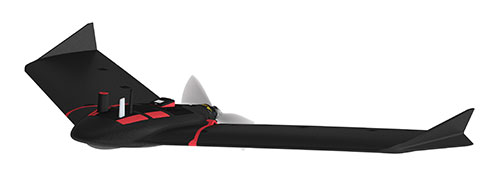
SenseFly, provider of fixed-wing drones, has launched the eBee X for mapping.
The eBee X, part of the Parrot Business Solutions portfolio, is designed to boost the quality, efficiency and safety of an operator’s geospatial data collection.
The eBee X. (Photo: senseFly)
It offers a camera to suit every job, the accuracy and coverage capabilities to meet the requirements of demanding projects, and is durable enough to work virtually every site, the company said.
“The eBee X is a giant leap forward for mapping technology and underscores senseFly’s position as the leader in the fixed-wing drone market,” said Gilles Labossière, executive vice president and COO of Parrot Group and senseFly CEO. “No matter what type of project a professional is undertaking, the eBee X has the coverage, data and accuracy capabilities needed to get the job done.”
The eBee X includes a range of cameras for jobs ranging from land surveying and topographic mapping to urban planning, crop mapping, thermal mapping, environmental monitoring and more. Cameras include:
The senseFly S.O.D.A. 3D: a unique drone photogrammetry camera with a one-inch sensor, which changes orientation during flight to capture three images (two oblique, one nadir) every time, instead of just one, for a much wider field of view. The result is stunning digital 3D reconstructions in vertically-focused environments—such as urban areas, open pit mines and coastlines—over larger areas than quadcopter drones can achieve. senseFly S.O.D.A. 3D is optimised for quick, robust image processing with Pix4Dmapper software.
The senseFly Aeria X: a compact drone photogrammetry camera with APS-C sensor. This rugged innovation offers an ideal blend of size, weight and DSLR-like image quality. Thanks in part to its built-in Smart Exposure technology, it provides outstanding image detail and clarity, in virtually all light conditions, allowing operators to map for more hours per day than ever before.
The senseFly Duet T: a dual-camera thermal mapping rig, which lets mapping professionals create geo-accurate thermal maps and digital surface models quickly and easily. The Duet T includes both a high-resolution (640 x 512 px) thermal infrared camera and a senseFly S.O.D.A. RGB camera with one-inch sensor. Both image sources can be accessed as required, while the rig’s built-in Camera Position Synchronisation feature works in sync with Pix4Dmapper photogrammetry software (optional) to simplify the map reconstruction process.
The eBee X is also compatible with the Parrot Sequoia+ multispectral camera for agriculture, the senseFly S.O.D.A. drone photogrammetry camera and senseFly Corridor for simple linear mapping.
The eBee X can meet the exacting requirements of every project. Its unique Endurance Extension option unlocks a flight time of up to 90 minutes (versus a maximum endurance of 59 minutes by default).
With this capability activated, the drone is able to achieve vast single-flight coverage of up to 500 hectares (1,235 acres) at 122 meters (400 feet), while the eBee X’s built-in High-Precision on Demand (RTK/PPK) function helps operators to achieve absolute accuracy of down to 3 centimeters (1.2 inch) — without ground control points.
According to senseFly, the eBee X allows users to work virtually every site, no matter how demanding, thanks to the drone’s built-in Steep Landing technology, ultra-robust design, live air traffic data and more, all backed by senseFly’s professional, localized support.
The eBee X is ideally suited to the varied and evolving needs of mapping professionals. These include: surveying and construction companies, quarry and mine operators, agronomists and forestry engineers, professional drone service providers, aerial imagery companies, environmental researchers and more, the company added.
The eBee X is supplied with senseFly’s eMotion flight planning and data management software.
A roundup of recent products in the GNSS and inertial positioning industry from the May 2018 issue of GPS World magazine.
SURVEY & MAPPING
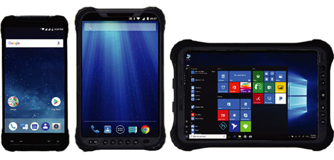
Rugged handhelds
Operate in harsh environments
The UT series of GNSS-capable rugged handheld devices support industries such as construction, survey, GIS, mapping, asset/logistics management, public safety, utilities and military. The UT10 6-inch rugged phone and UT30 8-inch rugged tablet both feature Android 8.0 operating systems with Qualcomm octa-core 2.2 GHz processors, 4 GB of RAM and 32GB onboard storage.The UT50 10.1-inch full-rugged tablet features the Windows 10 operating system with an Intel Core Skylake i5 processor up to 2.8 GHz, 8 GB RAM and 128 GB of onboard storage. All three new UT models provide the latest high-resolution, capacitive touchscreen and direct sunlight-readable display technology for ease of visibility in all situations. The UT50 also has a 10-finger multi-touchscreen and supports wet hands and gloves operation. The devices have dual built-in cameras. They are designed to be drop-resistant from heights of 1.2 meters (1.5 meters for the UT10), are rated at IP67 (IP68 for UT50), and are certified to both MIL-STD-810G and MIL-STD-461F military standards to ensure durability in most outdoor or challenging environments.
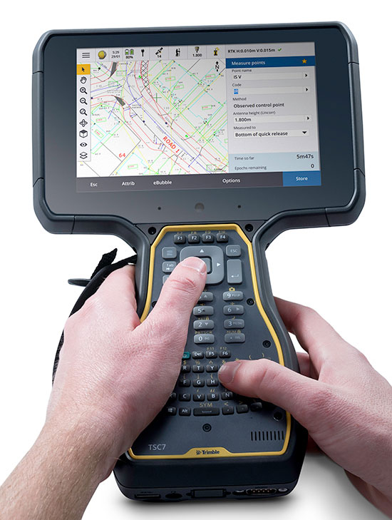
The Trimble TSC7 controller is a new field solution for land and civil construction surveyors. Equipped with GPS, it provides a tablet experience with a physical keyboard and a sunlight-readable 7-inch touchscreen that supports pinch, tap and slide gestures. Front- and rear-facing cameras allow users to video conference their office from the field for on-the-job support, and capture high-definition videos and images that provide valuable context to their data and clients. The TSC7 uses Windows 10 Professional with an Intel Pentium 64-bit quad-core processor. The processor and operating system make it easy to process data in spreadsheets and run office software programs. An ergonomic form factor, IP68-certified rugged design and optional, user-interchangeable modules make the TSC7 a flexible solution for all surveying applications.
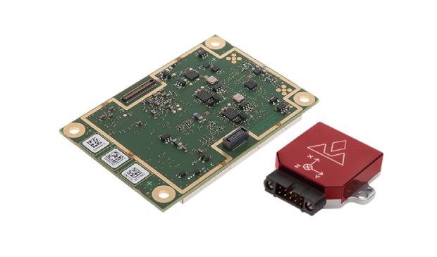
The AsteRx-i combines a multi-frequency multi-constellation GNSS engine with an external industrial-grade MEMS-based inertial measurement unit (IMU) to deliver positioning to the centimeter level as well as full 3D attitude at high update rates and low latency. The AsteRx-i is suitable for optical inspection and photogrammetry. Accompanied by a UAS-tailored carrier board, it integrates seamlessly into light UAVs. It also features Septentrio’s AIM+ interference monitoring and mitigation system.
UAS startup DropCopter has initiated a drone pollination service that uses multi-rotor drones to dust almonds, pistachios and cherries, boosting crops by up to 15 percent. Dropcopter’s patent-pending Worker-Bee pollinator helps growers overcome environmental factors like bee shortages, as well as wind, cold, and night time that would prevent honeybee activity. The company is partnered with GENIUS NY and The NUAIR Alliance.
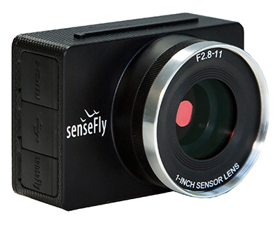
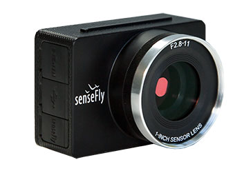
Sensor Optimized for Drone Applications (S.O.D.A.)
Photo: senseFly
The senseFly S.O.D.A. camera is built for professional drone photogrammetry work. It captures sharp aerial images across a range of light conditions, allowing users to produce detailed, vivid orthomosaics and ultra-accurate 3D digital surface models. It has a 1-inch 20 megapixel RGB sensor that provides ground resolution of 2.9 centimeters per pixel flying at 400 feet (122 meters) above ground level. It has built-in dust and shock protection, enabling mapping across challenging terrain.
SenseFly is partnering with Trimble to optimize the drone mapping workflow for geospatial professionals.
The new integration is designed to ensure a smooth end-to-end mapping drone workflow. senseFly operators can now, within the recently launched eMotion 3.5 software, transform a senseFly S.O.D.A. camera’s georeferenced imagery into an automatically collated project (in .jxl format).
This enables the one-click import of drone imagery into the Trimble Business Center Aerial Photogrammetry module without the need for manual project creation and organization of images.
The senseFly-to-Trimble mapping workflow includes:
planning and monitoring a senseFly S.O.D.A.-based drone flight (in eMotion 3.5)
downloading the drone’s images for one-click georeferencing in eMotion 3.5 (Flight Data Manager)
clicking to create a .jxl format mapping project
opening a project within the Trimble Business Center Aerial Photogrammetry module
processing the drone’s imagery to generate orthophotos, contour maps, point clouds, digital surface models (DSMs) and feature maps
analyzing and acting upon the data.
Screenshot: Trimble
“Making work easier and more efficient for geospatial professionals is the goal that drives every solution we develop,” said Jean-Christophe Zufferey, senseFly co-founder and CEO. “Therefore, we are excited to collaborate with Trimble on more tightly integrating our solutions, since enhancements such as this new eMotion-to-Trimble Business Center workflow do exactly that, ensuring that the transition from data collection to acting upon this data is as seamless as possible.”
The senseFly S.O.D.A. is built for professional drone photogrammetry work. The 1-inch, 20-megapixel RGB camera captures sharp aerial images across a range of light conditions, allowing senseFly fixed-wing drone operators to produce detailed, vivid orthomosaics and ultra-accurate 3D digital surface models.
senseFly S.O.D.A. is compatible with most senseFly fixed-wing mapping drones, including the large-coverage eBee Plus.
Trimble Business Center allows surveyors and other geospatial professionals to combine aerial photography with data collected from GNSS receivers, total stations, 3D laser scanners and more, for a complete field-to-finish workflow. By combining imagery from unmanned aerial systems with ground-based survey data, users can visualize their project from both aerial and terrestrial perspectives, measure points within the images and create 3D models of the infrastructure and terrain.