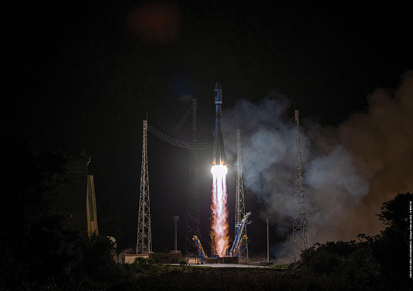
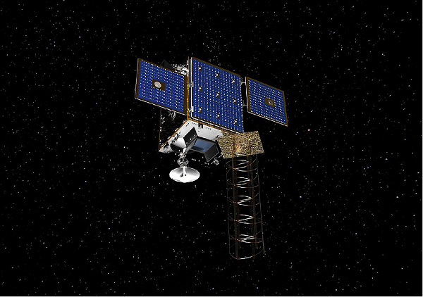
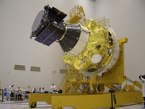
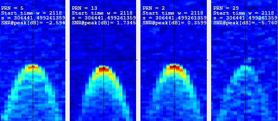
Galileo launch 11 from Europe’s spaceport in French Guyana sent satellites 27 and 28 into orbit. (Photo: ESA/CNES/Arianespace)
News from the European Space Agency (ESA)
Europe’s latest Galileo satellites in space have joined the operational constellation, transmitting navigation signals to three billion users across Earth as well as relaying distress calls to rescuers.
Their entry into service follows a summer test campaign and will result in a measurable increase in positioning accuracy and improved data delivery performance of the overall Galileo system.
Galileo satellites 27-28 were launched at the end of 2021 and underwent in-orbit test review at the end of April. The review was conducted by ESA, satellite manufacturer OHB, and navigation payload maker Surrey Satellite Technology Ltd (SSTL).
Key findings showed both satellites’ payloads are performing extremely well — among the best in the entire constellation — and the satellites entering into service increase the position accuracy and robustness of the overall Galileo system.
A successful system and in-orbit operations review followed, co-chaired by ESA and the EU Agency for the Space Programme (EUSPA), which is in overall charge of commissioning.
Improved navigation message
The two satellites are the first to broadcast an improved navigation message, resulting in three key improvements for Galileo’s public Open Service users:
faster navigation data acquisition, allowing users to establish a first position fix more rapidly
better robustness in challenging environments, such as urban centers
easier access to timing information in the navigation message for users possessing only a rough estimate of timing of the order of 1-2 seconds.
For the testing and broadcasting of this new navigation message, new software for the Navigation Signal Generation Unit was developed by Thales Alenia Space in Italy, SSTL, OHB and ESA, and was uploaded to the two satellites.
During the summer, an extensive test campaign was conducted by ESA to ensure the compatibility of the entire Galileo system at unit, payload, satellite, ground and system levels with the enhanced message. As part of this effort, EUSPA oversaw receiver testing to ensure this compatibility extended to Galileo receivers and chipsets in the market.
These latest launched satellites made ideal test cases for the software and the improved navigation message. Transmission of the upgraded signals from Galileo satellites 27-28 allowed the team to confirm its correct implementation and characterize its long-term performance.
Following a successful Test Review Board, the satellites were brought back into service on Aug. 29
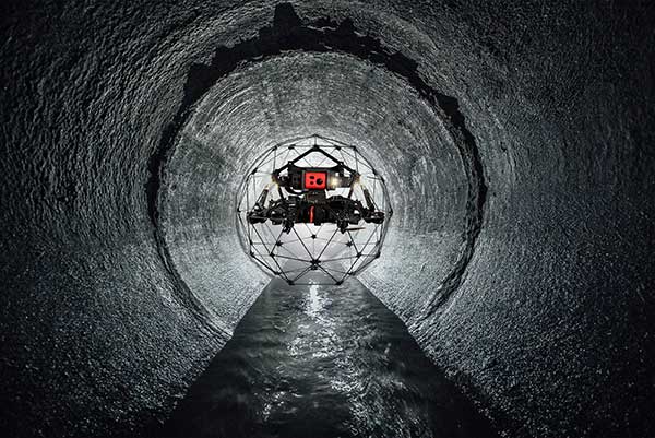
This month our UAV and GNSS news ranges from a drone diving into the Boston subway to a GNSS receiver designed for Moon orbit. We also look at the types of drones heading to Ukraine to help fight the Russian invasion and rescue citizens from demolished buildings.
Boston cleanup
Bostonians’ morning commutes were disrupted at the end of March after 100 tons of demolition debris fell nine stories onto ground directly above subway tunnels, and the Massachusetts Bay Transport Authority (MBTA) closed the Orange and Green lines as a precaution.
The bad news got worse. A construction worker was killed when part of a parking garage under demolition collapsed. Apparently his jackhammer-construction vehicle — in the midst of demolition work — fell nine stories when the floor near the edge of the building buckled and crumbled away.
MBTA was concerned that damage could have occurred to the subway under the building from the huge amount of debris that fell on the ground above a tunnel. The agency closed the line passing through that section of the system. Hundreds of morning commuters were turned away from the subway at nearby station entrances and were directed to buses hastily brought on as temporary shuttles around the closed subway sections.
MBTA wanted to immediately, but carefully, inspect the tunnel for damage, but was concerned for the safety of its inspection personnel. As news of the disaster circulated, the Massachusetts Department of Transportation (MassDOT) Aeronautics Division became aware of the subway issue, and proposed a rapid solution to the dilemma — to fly a drone through the tunnel. The drone would transmit high-resolution video and gather data on the status of both tracks and tunnel structure.
Soon after, Bostonians were able to watch a 29-second video collected by the drone that was sent into the subway tunnel.
“As we work to safely restore service following the Gov Center Garage accident, we teamed with @MassDOT Aeronautics to scan Orange & Green Line tunnels with a drone. This allowed us to safely assess tunnel conditions before sending engineers in for in-depth structural inspections.” pic.twitter.com/LHGUfiou9r
MBTA was then able to gauge that live inspections would be safe. The tunnel was ultimately assessed as being sound and, following test trains being run, service was restored.
It has been difficult to establish which drone was used for these initial visual tunnel inspections, but in 2021 the Aeronautics Division was operating multiple drones, including the DJI Matrice, Inspire, Phantom and Mavic, as well as a few fixed-wing and multi-rotor models manufactured by Yuneec, SenseFly and Delair.
Flyability provides the Elios 2 drone, specifically built for indoor inspection, for such places as inside underground tunnels. Similar “caged” inspection drones include Droneball 360 by Imaze, the Skycopter Cobra drone, the Asio Caged Inspection Drone and several others.
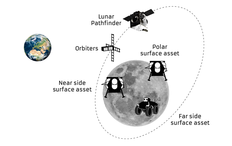
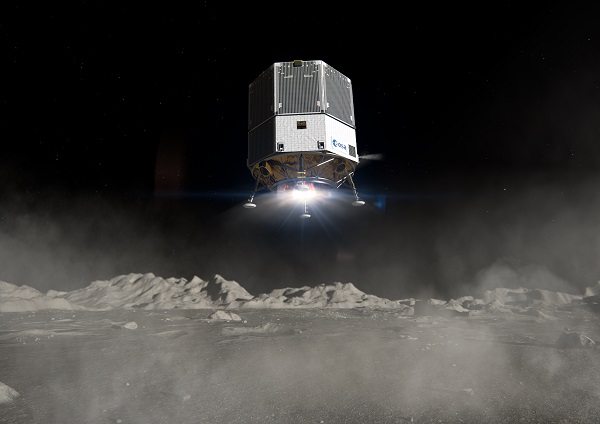
Turning our attention to space, the European Space Agency (ESA) will conduct a mission to place a refrigerator-sized satellite in orbit around the Moon. Of course, there have been many successful efforts to put things in lunar orbit since Russia first achieved the feat with Lunar 10 in 1966. NASA’s Lunar Reconnaissance Orbiter followed in 2009, along with India’s Chandrayaan-2 orbiter and its failed lander.
ESA has contracted Surrey Satellite Technology Ltd. (SSTL) in Guildford, UK, to develop the Lunar Pathfinder communications relay satellite — the first part of a project to provide communications and navigation for the Moon. This capability will enable assets on the lunar surface to communicate directly with the Pathfinder via S-band and UHF, which will then relay their signals onwards to Earth using X-band.
The satellite will also carry a laser retro-reflector and a space-weather payload designed to assess the radiation environment in orbit. This should help support landers carrying astronauts, such as the NASA Artemis, by broadcasting radiation intensity to the surface.
Artist illustration of the Pathfinder mission. (Image: SSTL)
The Lunar Pathfinder satellite. (Image: SSTL)The Pathfinder satellite will carry a few passenger payloads, but the most interesting to us might be the highly sensitive GNSS receiver, which will attempt to make position fixes from lunar orbit using GPS and Galileo satellites in Earth orbit.
The NaviMoon receiver designed by SpacePNT in Switzerland was implemented and tested by European Engineering & Consultancy, which added a special low-noise amplifier of its own design — essential for detecting minute satnav signals at 20 times the distance they usually travel to Earth’s surface from Earth orbit. In addition, antennas on GNSS satellites are designed for transmissions towards the Earth’s surface, not out toward space, further decreasing the signal strength in the vicinity of the Moon.
As you might expect, the view of the various constellations of GNSS satellites from orbit around the Moon is extremely limited. To give the NaviMoon receiver any sort of chance of picking up signals when they are in view, an onboard dynamic force model provides the receiver with its anticipated location along its orbit, and also derives the apparent direction from which signals should be observed. Even detecting a single satnav signal could assist the receiver in creating a position fix. SSTL will also reorient the Lunar Pathfinder satellite from time to time to enable the receiver to gain access to GNSS signals from Earth.
Measurements from Earth using laser ranging, aimed at the laser retro-reflector on the satellite, will be used as “truth” against which the position fixes by the NaviMoon receiver will be verified.
UAVs for Ukraine
Meanwhile, as the war in Ukraine continues to rage on, AeroVironment has been contracted by the U.S. Army to supply its RQ-20 Puma AE for use in Ukraine for almost $20 million. The package includes reconnaissance/surveillance and target acquisition kits, spares, logistics support and training for operators in Ukraine.
The Puma has an endurance of about three hours, carries a gimbaled visual/IR camera and is equipped with dual GPS receivers.
AeroVironment’s Puma is hand-launched. (Photo: Lance Cpl. Frank Cordoba/U.S. Marine Corps)
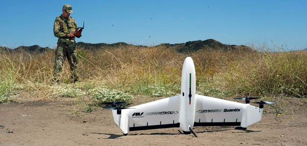
U.S. drone manufacturers have donated hundreds of other recon drones to Ukraine. The AeroVironment Quantix Recon drone takes off and lands vertically, but flies rapidly as a fixed-wing observation platform. While its endurance is not as long as the Puma’s, it flies faster so it can return with information more quickly.
Quantix lands vertically, but flies fixed wing. (Photo: AeroVironment)
Brinc has also donated and sold its Lemur tactical drones to Ukraine for use in disaster recovery work in devastated buildings throughout the country. The rugged quadrotor drone has two-way voice communications, video and lidar, and has proven itself in difficult building-collapse search and recovery operations in confined spaces. Skydio has apparently donated and sold quadrotor drones to Ukraine with multi-view video from six 200-degree color cameras, also for use in collapsed building search and recovery.
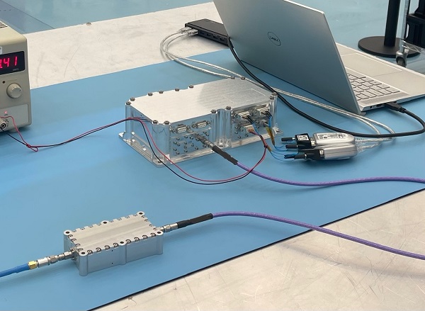
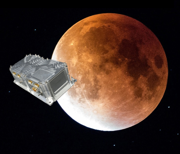
The test version of a unique satellite navigation receiver has been delivered for integration testing on the Lunar Pathfinder spacecraft.
The NaviMoon satnav receiver is designed to perform the farthest ever positioning fix from Earth, employing signals that will be millions of times fainter than those used by smartphones or cars on Earth.
The NaviMoon receiver and low-noise amplifier. (Photo: SSTL)
“This engineering model of our NaviMoon receiver is the very first piece of hardware to be produced in the context of ESA’s Moonlight initiative, to develop dedicated telecommunications and navigation services for the Moon,” explained Javier Ventura-Traveset, head of ESA’s Navigation Science Office and manager of ESA lunar navigation activities.
“It will be flown aboard the Lunar Pathfinder mission into orbit around the Moon, from where it will perform the furthest satellite navigation positioning fix ever made, at more than 400,000 kilometers away to an accuracy of less than 100 meters,” Ventura-Traveset said. “This represents an extraordinary engineering challenge, because at such a distance the faint Galileo and GPS signals it uses will be barely distinguishable from background noise. This demonstration will imply a true change of paradigm for lunar orbiting navigation.”
The washing-machine-sized Lunar Pathfinder is being built as a commercial mission by Surrey Satellite Technology Ltd. (SSTL), in the United Kingdom. ESA is funding guest payloads for it, including the 1.4-kg NaviMoon receiver that will be accommodated beside the spacecraft’s main X-band transmitter that links it with Earth.
“Receiving physical hardware for a mission is always fantastic,” said Lily Forward, SSTL system engineer. “This engineering model receiver will be integrated into our FlatSat Test Bed version of the mission to test that all our systems communicate and work together properly, ahead of receiving the flight-model receiver and antenna later this year.”
This will be SSTL’s first full-fledged mission beyond Earth, she added. “Laying the foundations for numerous scientific missions that will come after it, Lunar Pathfinder is a communications relay satellite, intended to serve assets on both the nearside and farside, orbiting in an elliptical lunar frozen orbit for prolonged coverage over the South Pole — a particular focus for future exploration. Then, during regular intervals, we will orient the spacecraft towards Earth to test out the NaviMoon receiver.”
Satnav position fixes from the receiver will be compared with conventional radio ranging carried out using Lunar Pathfinder’s X-band transmitter as well as laser ranging performed using a retroreflector contributed by NASA and developed by the KBR company.
“This will be the first time these three ranging techniques will be used together in deep space,” explained ESA navigation engineer Pietro Giordano. “There is a long heritage of lunar laser ranging, going back to the Apollo missions, and the retroreflector we are using is an evolution from NASA’s Lunar Reconnaissance Orbiter. The combination of all ranging techniques will improve the orbit estimation further, potentially beyond what radio ranging can achieve.
“In principle, this could mean that future missions could navigate themselves to the Moon autonomously using satellite navigation signals alone with no help from the ground.”
The satnav signals employed here on Earth are already vanishingly faint, equivalent to a single pair of car headlights shining all across Europe. By the time these signals reach the Moon, they have crossed distances of more than 20 times further, attenuating through space like ripples from a stone splashed in water.
“Adding to the difficulty, the satnav constellations are not designed to transmit up into space, but to keep their antennas facing Earth,” Giordano said. “So we are reliant on much weaker side-lobe signals, like light spilling from the sides of a flashlight. To be able to make use of these signals, we turned to a specialist in space-based satellite navigation, whose signal-processing techniques have really proven the magic ingredient.”
Testing the NaviMoon receiver and Low Noise Amplifier engineering models at SSTL ahead of integration testing. The flight models of the receiver and amplifier will be delivered later in 2022. (Photo: SSTL)
SpacePNT, based in Switzerland, oversaw the NaviMoon receiver design. “We began working on the idea of lunar-distance satnav positioning back in 2013 as something of a scientific challenge,” said Cyril Botteron, company head.
“The combination of Galileo dual-frequency signals with those of the existing GPS satellites is what started to make it feasible,” Botteron said. “Although, along with the extreme sensitivity that is demanded, the other big problem is that from the Moon all the satnav satellites are in the same narrow geometry of sky around Earth, periodically rotating out of view.”
Lunar navigation satellites will ultimately help guide Moon landings, such as with the European Large Logistic Lander. (Image: ESA)
The solution that SpacePNT came up with leverages more than half a century of lunar exploration. The company installed a dynamic software model of all the forces acting upon the satellite into the receiver, including the gravitational influences of the Moon, Earth, Sun and planets as well as the very slight push from sunlight itself — solar radiation pressure — along with factors such as clock error and the radio signal direction.
“As we experience a given acceleration the receiver can judge it is most probably at one particular point in its orbit,” Botteron said. “Usually a satnav receiver needs signals from four satellites to fix its position, but with this approach, less than four signals is still enough to obtain useful information, constraining the model to minimize any error drift.”
European Engineering & Consultancy (EECL) in the UK was assigned the task of turning SpacePNT’s design into fully tested hardware, and also designed the crucial low-noise amplifier that sifts through noise to boost usable signals.
Artist’s rendering of GIOVE-A in orbit. (Image: ESA)
News from the European Space Agency
Europe’s first prototype satellite for Galileo, GIOVE-A, has been formally decommissioned after 16 years of work in orbit. The GIOVE-A mission in 2005 secured Galileo’s radio frequencies for Europe, demonstrated key hardware, and probed the then-unknown radiation environment of medium-Earth orbit.
“If not for GIOVE-A, the 26 Galileo satellites in orbit today would not exist,” said Paul Verhoef, ESA’s director of navigation. “Its speedy development and launch opened the way for our working constellation to follow.”
ESA had begun designing Galileo at the turn of the century, and radio frequencies had been set aside for the new system by the International Telecommunications Union. But these frequency filings came with a deadline attached: the frequencies had to be used from orbit by mid-2006 or they would lapse.
GIOVE-A was launched by Soyuz from Baikonur cosmodrome in Kazakhstan on Dec. 28, 2005. (Photo: ESA)
GIOVE-A Sped to Orbit
Galileo In-Orbit Validation Element-A, or GIOVE-A, was produced at a breakneck pace to meet this deadline. Developed in the second half of 2003, the satellite was designed, built and tested before the end of 2005, and launched on Dec. 28 of that year.
“At the time there was a lot of uncertainty: Would we make it or not?” recalled Javier Benedicto, head of the Galileo Project Department, ESA. “GIOVE-A transmitted its first Galileo signal-in-space on Jan. 21, 2006, meaning that Europe was formally in the navigation business.”
That March, ESA formally confirmed it had brought the Galileo-related frequency filings into use, three months ahead of the official ITU deadline.
Europe’s first navigation satellite GIOVE-A, short for Galileo In-Orbit Validation Element-A, during flight preparation. (Photo: ESA)
The mission also carried a prototype rubidium atomic clock — proving its functionality for the operational Galileo satellites that would follow — as well as a radiation instrument. Medium Earth orbit, 23,000 km altitude, was terra incognita at this point for European satellites, but it was known to possess enhanced radiation levels from the impinging of the outer band of Earth’s Van Allen radiation belts.
A second Galileo prototype, GIOVE-B, followed in 2008, this time hosting a prototype passive hydrogen maser — the second type of atomic clock that Galileo relies on — along with an enhanced payload able to transmit for the first time the GPS-Galileo common signal.
GIOVE-A Succeeded at New Mission
Once the first Galileo satellites were in orbit and working well, ESA ended use of GIOVE-A in 2012. The satellite was placed in a graveyard orbit 100 km above the operational satellites’ orbits, as was GIOVE-B after its own four-year mission.
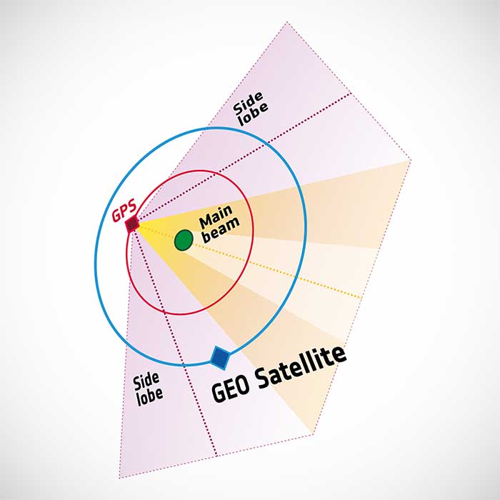
Control of GIOVE-A passed to manufacturer Surrey Satellite Technology Ltd (SSTL) in the United Kingdom. GIOVE-A was then employed for various in-orbit experiments, including demonstrating the reception of satellite navigation signals from GPS satellites orbiting below it — based on spillover sidelobe reception from satellites on the other side of Earth.
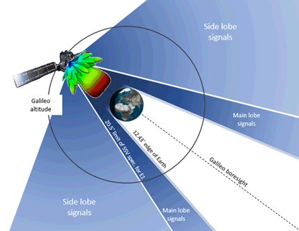
GIOVE-A was able to make use of signals emitted sideways from GPS antennas, within what is known as “side lobes.” (Image: ESA)
This proof that satnav can be relied on further out into space means that satellites in geostationary orbit are making use of satnav for positioning. As a next step, ESA is planning to extend satnav coverage all the way to the Moon.
The satellite also continued its radiation survey of medium-Earth orbit, acquiring a unique record extending across more than 10 years, analyzed by the Surrey Space Centre with ESA support. Multiple scientific papers have been written on these results, which encompass the “electron desert” of 2008-9 during the lowest levels of solar activity of the space era, followed by one of the largest electron storm events on record in April 2010.
A new model of the outer Van Allen belt electron fluxes, MOBE-DIC, has been produced from this dataset, helping to guide future satellite designs.
“Actually, the satellite itself is still operating well,” said Sarah Lawrence, SSTL. “The reason for ending the mission is software obsolescence in our control center. The decommissioning procedure involved transitioning the satellite to Earth-pointing mode, turning off the reaction wheels and setting the attitude and orbit control system to standby mode, before finally switching off the on-board computer and transmitter.”
“GIOVE-A over-delivered on its original lifetime and mission goals – an inspiring and game-changing mission on so many levels,” said Martin Sweeting, SSTL executive chairman.
SSTL went on to provide navigation payloads for operational Galileo satellites. Today, 26 Galileo satellites orbit the Earth. Galileo has become the world’s most precise satnav system, delivering meter-scale accuracy to more than 2.3 billion users around the globe.
Swiss company SpacePNT will develop an advanced spaceborne GPS/Galileo receiver to demonstrate for lunar navigation and positioning.
A vision of the NAVIMOON receiver. (Image: SpacePNT)
The European Space Agency (ESA) has selected SpacePNT to develop an advanced spaceborne GPS/Galileo receiver to demonstrate the use of terrestrial satellite navigation signals or real-time and autonomous orbit determination and positioning, navigation and timing (PNT).
The receiver will be carried aboard the ESA-SSTL Lunar Pathfinder spacecraft, which will be placed in orbit around the Moon.
The contract includes the development, qualification and delivery of one proto-flight model (PFM) and two engineering models of the NAVIMOON receiver. NAVIMOON is the high-sensitivity version of SpacePNT’s NAVILEO high-performance GNSS spaceborne receiver.
The NAVIMOON receiver implements high-sensitivity algorithms able to receive and process signals extremely attenuated coming from the spillover (side lobes) around the Earth of signals transmitted by satellite navigation systems. It combines these signals’ measurements with advanced on-board orbital filters to achieve onboard the spacecraft in real time an unprecedented target orbit determination accuracy of 100 meters root-mean-square (rms) at Moon altitude, which is well above the typical accuracy that can be achieved with terrestrial radio ranging that involves the use of costly deep-space-station ground infrastructures.
Given the high interest in Moon exploration and colonization (more than 50 commercial and governmental missions have been announced between now and 2024), it is expected that this NAVIMOON receiver technology will play a significant role in the next decade not only on Earth-Moon transfer orbits, but also to provide enhanced PNT services for users on the Moon. Deployment of a lunar constellation will allow the provision of lunar navigation in Moon-obstructed areas.
For this project, SpacePNT will partner with EECL from the UK. EECL will work as a subcontractor and bring significant space expertise to the electronics design, manufacturing and qualification of the receiver.
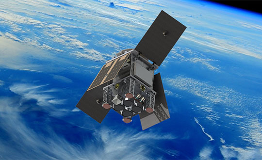
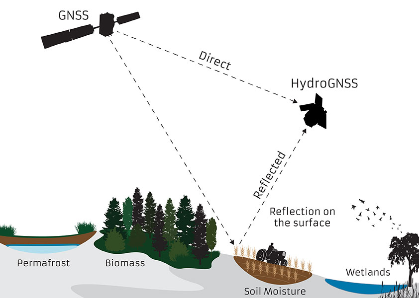
The small satellite will measure climate variables using GNSS Reflectometry
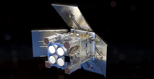
The European Space Agency (ESA) has selected HydroGNSS from Surrey Satellite Technology Ltd. (SSTL) for its second Scout Earth Observation small satellite mission. HydroGNSS is a 40-kg satellite that will be built and operated by SSTL.
ESA selected the first ESA Scout satellite, ESP-MACCS, in December 2020. ESP-MACCS focuses on understanding and quantifying processes in the upper atmosphere over the tropics — processes that play an important role in the overall evolution of the atmosphere.
HydroGNSS will take measurements of key hydrological climate variables, including soil moisture, freeze thaw state over permafrost, inundation and wetlands, and aboveground biomass, using GNSS reflectometry. It will complement missions such as ESA’s SMOS and Biomass, Copernicus Sentinel-1 and NASA’s SMAP.
Both small satellites are expected to be the first in a series of ESA Scout missions demonstrating how small satellites on a budget of less than €30 million and a three-year schedule can play an important role in Earth observation, and be scaled up for future missions.
Knowledge of these variables helps scientists understand climate change and contributes towards weather modelling, ecology mapping, agricultural planning and flood preparedness.
“SSTL pioneered GNSS reflectometry, providing the payloads on TechDemoSat-1 and the NASA CYGNSS mission for measuring ocean wind speeds, and I am delighted that we will now launch the first satellite mission specifically addressing hydrological measurements using this innovative technique,” said Phil Brownnett, SSTL managing director.
Previously, addressing hydrological variables such as these has required sizable and higher cost satellites with large aperture antennas, but GNSS reflectometry uses existing signals from GNSS as radar signal sources. These signals are reflected off the land, ice and ocean and can be collected by a low power receiver on a small satellite in low Earth orbit, and used to yield important geophysical measurements.
Image: SSTL
SSTL is working closely with partners to tackle the scientific and technological challenges involved. Partners include Sapienza, Tor Vergata and IFAC-CNR in Italy; FMI in Finland; IEC/IEEC in Spain; and NOC and the University of Nottingham in the United Kingdom (UK),
“The decision to implement HydroGNSS after ESP-MACCS demonstrates that the Earth observation community is very interested in the concept of Scout missions. We are confident that this interest will further flourish when we see the first data in 2024,” said Toni Tolker-Nielsen, ESA’s acting director of Earth Observation Programmes.
As well as the already established GNSS-Reflectometry measurements, new techniques will be explored on HydroGNSS, including use of Galileo signals, dual polarization, dual frequency and recovery of coherently reflected components. These new measurements are expected to improve the separation, resolution and quality of the climate variables under observation.
The HydroGNSS mission exemplifies the UK’s innovation in climate change research, according to SSTL. The 26th United Nations Climate Change Conference takes place in the UK Nov. 1-12.
Image: SSTL
“The UK is leading the way in using space to tackle climate change, with Earth Observation satellites providing some of the most important data to monitor our environment as we build back greener,” said Science Minister Amanda Solloway. “Using a UK satellite just the size of a microwave oven, this pioneering mission will build on the UK’s expertise in space research by measuring changes in the Earth’s water, providing crucial information to address climate change, improve farming and support wider disaster management.”
HydroGNSS paves the way for an affordable future constellation that can offer measurements with a temporal-spatial resolution not accessible to traditional remote-sensing satellites, thus offering new capacity to monitor very dynamic phenomena and helping to fill the gaps in our monitoring of the Earth’s vital signs for the future.
The successful demo consolidates concept designs for a proposed land-sensing ESA Scout mission, HydroGNSS
Surrey Satellite Technology Ltd. (SSTL) has successfully demonstrated GNSS reflectometry (GNSS-R) from its 18-kg DoT-1 satellite. SSTL has pioneered the new field of GNSS-R with successful payloads on board TechDemoSat-1 and the CYGNSS constellation, and is continuing to develop the technology and data analysis in pursuit of this new science.
SSTL’s DoT-1 satellite was launched in 2019. (Photo: SSTL)
The GNSS-R payload onboard the DoT-1 satellite is incorporated within a new small-form-factor Core Avionics module integral to all SSTL’s future satellite platforms. This innovation paves the way for any SSTL satellite that can accommodate a nadir pointing antenna to become part of a GNSS-R small-sat constellation.
GNSS reflectometry is an Earth-observation technique that uses GNSS signals as L-band radar sources, allowing the satellite to take measurements of ocean wind speeds, polar ice and hydrological land parameters, at a higher spatial resolution and an order of magnitude lower cost than other methods.
“GNSS-R is a powerful new science that can contribute valuable data to help monitor changes in our global climate, and I am really pleased with the success of our DoT-1 demonstration.,” said Phil Brownnett, managing director of SSTL. “We now have an advanced instrument design and deep expertise in this new field, and I am hopeful that SSTL’s HydroGNSS concept will progress to a full mission to support the global climate-control challenge.”
HydroGNSS mission
The GNSS-R technology demonstration from SSTL’s DoT-1 satellite is also an important stepping stone for a proposed European Space Agency (ESA) Scout Mission Concept called HydroGNSS, which comprises two 40-kg satellites that collect data continually in near-polar orbits, taking hydrological measurements over the whole globe.
The HydroGNSS mission concept makes advanced use of new GNSS reflectometry techniques such as Galileo signals, dual polarization, and coherent signal acquisition to measure four Essential Climate Variables (ECVs) over land: soil moisture, inundation, permafrost freeze/thaw, and biomass. HydroGNSS has been down-selected by ESA for a concept study; the finally selected Scout mission will commence in 2021.
The below animated video illustrates the HydroGNSS mission.
SSTL’s GNSS-R instrument collects and processes measurements into a “delay Doppler map” (DDM) that can be corrected and inverted into Level 2 products such as ocean wind speed, as has already been successfully demonstrated by the SSTL GNSS-R instruments onboard the TechDemoSat-1 and CYGNSS missions.
The plot below shows results from data gathered by the DoT-1 satellite on Aug. 12, and shows simultaneous DDMs from four separate GPS satellites. As this is a forward scattering technique, the stronger signals with redder peaks indicate a calmer ocean with lower wind speeds. Approximately 40 minutes of data were collected from the Pacific to the Antarctic to the Southern Ocean.
DoT-1 sub-satellite track (white) and GPS reflection tracks (yellow) collected during 40 minute data operation. (Image: SSTL)Four Delay Doppler Maps (DDMs) collected by DoT-1 that show signal reflections from four GPS satellites. (Image: SSTL)
Soil moisture measurements
Data from the SSTL GNSS-R instruments onboard the CYGNSS mission have demonstrated the potential for soil moisture measurement by GNSS reflectometry, and preliminary work shows that GNSS-R also has good sensitivity for freeze/thaw sensing in the active zone of permafrost. Unseasonal changes in the permafrost cycles could potentially release larger quantities of methane, which risks exacerbating global climate change.
GNSS-R can also be used to assess biomass, a measure of forest density which acts as a vital sink for removing carbon dioxide from the atmosphere. In addition to longer term climate observations, soil moisture and inundation measurements from GNSS reflectometry can provide important information for short-term operational purposes, for example, towards Numerical Weather Prediction and flood warnings following rainfall events.
The development of SSTL’s new GNSS-R instrument was funded in part by the European Space Agency.
Airbus has enlarged its high-resolution imagery portfolio following an agreement to leverage capacity from the S1-4 satellite built by Surrey Satellite Technology Limited (SSTL). The new imagery offer — called Vision-1 — delivers end-to-end imaging operations to Airbus’ customers.
Vision-1 provides 0.9-meter resolution imagery in the panchromatic band and 3.5-meter in the multispectral bands (NIR, RGB), with a 20.8-kilometer swath width. These specifications are ideal for defence, security and agriculture applications, while this extra revisit opportunity further strengthens Airbus’ satellite fleet.
“This new asset will reinforce our monitoring capabilities for sub-metre imaging, and feed our OneAtlas digital platform to provide increased freshness,” said François Lombard, director of Intelligence Business at Airbus Defence and Space.
Vision-1 operations will be coordinated by Airbus in the UK, following integration into the UK Mission Operation Centre, which operates the commercial imaging of the DMC Constellation. This is an important step for UK sovereign imaging capability, Airbus said, adding sub-meter data to the existing UK imaging capabilities.
As Vision-1 was launched in September 2018 together with NovaSAR, this opens significant opportunities for applications combining optical and radar satellite imagery.
Along with Vision-1, Airbus offers commercial access to the largest fleet of Earth Observation satellites: Pléiades, SPOT 6/7, DMC Constellation and the weather-independent radar satellites TerraSAR-X, TanDEM-X and PAZ.
Galileo is on the march with a new generation of satellites bearing improved atomic clocks. The first of the Batch 3 navigation payloads was delivered in June by Surrey Satellite Technology (SSTL) in the UK to OHB System AG in Bremen, Germany.
SSTL’s payload for Batch 3 is a recurrent build of the existing FOC payload, with an evolution of the atomic clocks to incorporate advances made under the European GNSS Evolution Programme. The earlier SSTL Galileo FOC payload comprised different units including European-sourced atomic clocks, navigation signal generators, high power traveling wave tube amplifiers and antennas.
The new payload will be integrated aboard the satellite platform Galileo FOC FM23, named Patrick in honor of the winner of a drawing competition. Payload integration will be followed by a series of comprehensive test activities. Patrick and its next youngest sibling satellite of this series are scheduled to be ready for launch in autumn 2020.
“We are looking forward to this first ‘marriage’ of a Batch-3-payload and platform and are ready to start Patrick’s test sequence soon,” said Lars Peters from OHB System AG, in charge of the Assembly Integration and Test for the satellites at eleven production islands where one satellite is completed every five weeks.
“The ambitious schedule means that looking forward reserve satellites will be available both in orbit and on the ground,” added Dr. Wolfgang Paetsch, a member of the OHB System AG Management Board responsible for navigation, Earth observation and science.
“Of course we are waiting a bit to see what the real lifetime of the satellites is going to be. We don’t know that yet but we will find out in the next couple of years. Obviously there is a lot of pressure for further innovation, for further improvements. The user community over the last couple of years has become more outspoken about what they want and what they expect, which is nice. Obviously we need to take care of the legacy users, and we are having to see what new technology would allow us to do.”
OHB System AG has contracted to deliver a further twelve satellites of this Batch 3 for Galileo. This will bring to 34 the number of Galileo satellites being supplied by the SSTL-OHB partnership. Of these, 14 are already in orbit.
Feature photo: The satellite Patrick, first of Galileo’s Batch 3, will eventually travel from OHB to ESA’s ESTEC technical centre (shown here) in Noordwijk, the Netherlands for rigorous testing in simulated space conditions. (Photo: European Space Agency)
Check out some GPS developments that have recently taken place around the world. (Click to enlarge; Map: iStock.com/nadla)
1. When horses answer the call
Taking a ride in a horse-drawn carriage delights many visitors to historic Charleston, South Carolina. Until now, city crews cleaning up the presents horses leave behind have relied on flag indicators left by carriage operators. Now the city is testing a new method. Carriage operators will send the exact location to equine sanitation crews using small GPS-enabled devices. When a horse or mule takes an on-street nature break, the guide presses a button, and the equine sanitation crew is notified of exactly where to go. When the cleanup is complete, the notification is deleted.
2. Detecting rain over the ocean
Despite a wide variety of monitored geophysical parameters, GNSS signals reflected off the Earth’s surface (GNSS reflectometry) have never been used to obtain rain information. A new study presents evidence that data from the U.K.’s TechDemoSat-1 potentially enables the GNSS-R technique to detect precipitation over oceans at low winds. The study — by scientists at the GFZ German Research Center for Geosciences at Potsdam — could serve as a starting point for developing a new GNSS reflectometry application, which might also be implemented for low-cost GNSS remote-sensing missions.
Click to enlarge. (Photo: Chocolateam)
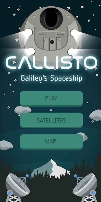
3. Gaming with Galileo
Gamers around the world can now play with the Galileo constellation. Callisto for Android uses Galileo signals in a virtual maze game based on walking through a real-world location. Looking down on Earth as if from a spaceship, players use a Google Map display to traverse an area filled with randomly generated obstacles and collectibles. The project began as an entry to European Space Agency’s Galileo App Competition 2017–2018 and was one of three apps that made it to the finals.
4. Guinness decision pending on world’s steepest street
Dunedin, New Zealand, claims to have the world’s steepest street (Baldwin), a title officially challenged in January by the town of Harlech, Wales, when residents walked up and down the narrow, winding Ffordd Pen Llech carrying a GNSS surveying receiver. A total of 14 data points were recorded on the 330-meter-long road, which had an altitude accuracy of ±5 centimeters. New Zealand surveyor Richard Hemi said the GNSS method used by the Welsh group might not be accurate. Best accuracy is to survey from the center of the road — easy on Baldwin St. but much more difficult on a winding lane. The survey was sent to Guinness World Records, which will issue a decision this spring.
The first global GNSS-reflectometry ocean-wind data service has been launched by Surrey Satellite Technology Ltd. (SSTL) with the National Oceanography Centre (NOC), and with support from the European Space Agency.
The online data service, dubbed MERRBYS (Measurement of Earth Reflected Radio-navigation signals By Satellite), is free.
Users can access measurements of wind taken by a specially designed GNSS receiver hosted on SSTL’s TechDemoSat-1 satellite, which collects signals reflected off the surface of the ocean. The service offers monthly maps of wind speed over the oceans.
TechDemoSat-1 is also collecting GNSS reflections off land and polar regions, opening the door for new applications of this technology, such as soil moisture and ice measurements.
TechDemoSat-1 was launched in 2014 and carried eight payloads from different U.K. organizations. On successful completion of the satellite’s original mission, a life extension now allows the GNSS reflectometry payload to be operated continuously.
Onboard processed GNSS-R data is relayed to SSTL’s ground station in the U.K. and inverted for geophysical parameters using NOC retrieval algorithms for the estimation of near-surface ocean wind speed.
Users have access to data from the past three years, and new data is added daily with a latency of 30 days. Users can also register for a fast service allowing retrieval of data with a shorter delay — currently 48 hours, but with a target of less than 24 hours as the service matures.
Pilot demonstration
The current service is a pilot demonstration showing the potential for a new source of wind and wave measurements from in orbit using a small satellite. In the future, a constellation of low-cost small satellites carrying enhanced instruments could provide measurements in near-real time to support weather and wave forecasting.
The TechDemoSat-1 satellite and payload were supported by U.K. Centre for Earth Observation Instrumentation and the U.K. Space Agency, and sponsorship from European Space Agency has allowed the release of data.
More than 50 international journal papers have been published based on the use of the TechDemoSat-1 GNSS-R data. GPS World first discussed the technology in a 1999 Innovation column by GPS World Leadership Award Winner Attila Komjathy, “GPS, a new tool for ocean science.”
SSTL also provided the same GNSS reflectometry instrument to the NASA CYGNSS mission, where eight small satellites are using this technique to probe and analyze hurricanes.
UK’s SSTL to build third batch of Galileo navigation payloads
News from the European Space Agency
Europe’s Galileo navigation constellation will gain an additional eight satellites, bringing it to completion, thanks to a contract signed at the Paris Air and Space Show.
The contract to build and test another eight Galileo satellites was awarded to a consortium led by prime contractor OHB, with Surrey Satellite Technology Ltd overseeing their navigation platforms.
This is the third such satellite signing: the first four In Orbit Validation satellites were built by a consortium led by Airbus Defence and Space, while production of the next 22 Full Operational Capability (FOC) satellites was led by OHB.
These new batch satellites are based on the already qualified design of the previous Galileo FOC satellites, except for changes on the unit level – such as improvements based on lessons learned and reacting to obsolescence of parts.
ESA’s Director of the Galileo Programme and Navigation-related Activities, Paul Verhoef, signed the contract with the CEO of OHB, Marco Fuchs and OHB Navigation Director Wolfgang Paetsch, in the presence of ESA Director General Jan Woerner and the EC’s Deputy Director-General for Internal Market, Industry, Entrepreneurship and SMEs, Pierre Delsaux.
“This procurement from OHB will enable the completion of the Galileo constellation and have reserves both in-orbit and on-ground,” said Director Verhoef. “This signing delivers the necessary infrastructure robustness that is essential for the provision of Galileo services worldwide.”
ESA signed the contract on behalf of the EU represented by the European Commission – Galileo’s owner. The Commission and ESA have a delegation agreement by which ESA acts as design and procurement agent on behalf of the Commission.
Signing Ceremony
Galileo is Europe’s own satellite navigation system, providing an array of positioning, navigation and timing services to Europe and the world.
With 18 satellites now in orbit, Galileo began Initial Services on Dec. 15, 2016, the first step towards full operational capability.
Further launches will continue to build the satellite constellation, which will gradually improve the system performance and availability worldwide. The launch by Ariane 5 of another four satellites is due to take place later this year.
The full Galileo constellation will consist of 24 operational satellites in three orbital planes plus orbital spares, intended to prevent any interruption in service.
These new eight satellites will provide the constellation with in-orbit and on-ground spares. ESA and the Commission are also in the process of developing an improved Galileo Second Generation for the next decade.
Galileo is now providing three service types, the availability of which will continue to be improved.
ESA’s Director of the Galileo Programme and Navigation-related Activities, Paul Verhoef (right), signing the contract of behalf of the European Commission, shakes hands with the CEO of OHB, Marco Fuchs beside OHB Navigation Director Wolfgang Paetsch, in the presence of ESA Director General Jan Woerner (in background) and the EC’s Deputy Director-General for Internal Market, Industry, Entrepreneurship and SMEs, Pierre Delsaux.
Galileo coverage
The Open Service is a free mass-market service for users with enabled chipsets in, for instance, smartphones and car navigation systems. Fully interoperable with GPS, combined coverage will deliver more accurate and reliable positioning for users.
Galileo’s Public Regulated Service is an encrypted, robust service for government-authorized users such as civil protection, fire brigades and the police.
The Search and Rescue Service is Europe’s contribution to the long-running Cospas–Sarsat international emergency beacon location. The time between someone locating a distress beacon when lost at sea or in the wilderness will be reduced from up to three hours to just 10 minutes, with its location determined to within 5 km, rather than the previous 10 km.
The public will begin benefiting as Galileo-capable devices enter the marketplace: 17 companies, representing more than 95% of global supply, now produce Galileo-ready chips.
SSTL continues Galileo work
“SSTL is delighted to have been selected to build the third batch of navigation payloads needed to complete the initial Galileo Constellation,” said Gary Lay, SSTL’s director of navigation. “I am confident that the OHB-SSTL solution offered the lowest risk and best value for money, and I believe that our selection as payload providers for the third time in succession demonstrates a high regard for our work.”
SSTL’s state-of-the-art Galileo FOC payload comprises different units including European sourced atomic clocks, navigation signal generators, high power traveling wave tube amplifiers and antennas. SSTL’s payload proposal for Batch 3 is for a recurrent build of the existing payload, with an evolution of the atomic clocks to incorporate advances made under the European GNSS Evolution Programme.
Fourteen of SSTL’s Galileo FOC navigation payloads are currently operational in orbit, with a further eight payloads already delivered to OHB for integration and test.
SSTL has been involved in the Galileo program since 2003 with the design and build of GIOVE-A, Galileo’s pathfinder mission. GIOVE-A was launched in 2005 and is still operational today, providing valuable data about the radiation environment in Medium Earth Orbit. An experimental GPS receiver on board GIOVE-A is also used to map out the antenna patterns of GPS satellites for use in planning navigation systems for future high altitude missions in Geostationary orbit, and beyond into deep space.