Tag: Tampa

  • Jamming warfare and air taxis

    Jamming warfare and air taxis

    Russian Pole-21 jammer – (photo: Defense Ministry, Russia)
    Russian Pole-21 jammer – (Image: Defense Ministry, Russia)

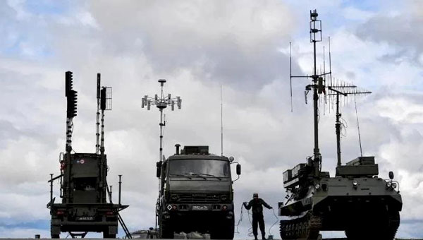
    Other than the tracked unit — a truck that appears to be a power generator and has an overall look of complexity — the thing that jumps out at you about the Russian Pole-21 jammer is that it is brisling with a huge number of antennae. The system apparently can jam almost any known communication channel and everything GNSS. It is a bit lumbering to move around, may be difficult to set up, and must be used judicially, because it may jam everything, including the Russian’s own coms and GLONASS navigation systems. So, it may be useful for disabling the enemy, but only when your own soldiers have already established visual contact with their target.

    The Russians just parked one of these contraptions in southern Ukraine’s Zaporizhzhia Oblast (district), which has been the focus of the Ukrainian counteroffensive for the last few months. However, the Ukrainians found it quickly, had time to figure out what to do with it and launched a GPS-guided weapon that destroyed the inoperative Pole-21 jammer. They may have caught the system either before it was fully activated or when it had been intentionally shut down to protect Russian forces. The Pole-21 set up was found during a drone recognizance flight and the system was then taken out by a Ukrainian aircraft — perhaps a Russian Sukhoi Su-27 or Mikoyan MiG-29 — which deployed a U.S. Joint Direct Attack Munition (JDAM) to destroy the system. The UAV, the aircraft, and the JDAM all use GPS for guidance, which is perhaps a little ironic. The Ukrainians have reportedly destroyed more than four dozen other Russian jamming systems since the start of the war.

    Just in case there might be reprisals, the Ukrainians have developed their own RF system that forms a 600-ft dome over the area/asset that needs protection from UAV attacks. Additionally, Western countries have supplied several jamming systems to the Ukrainian forces for more elaborate, wider range jamming protection.

    Ukraine initially shot down low flying, slow Russian UAVs with rifles and large caliber anti-aircraft defense systems; however, as expensive missile systems have become available from the United States and elsewhere, it has become apparent that it is too expensive to use complex missiles to bring down large numbers of inexpensive commercial UAVs. It just does not make sense — too many UAVs and not enough expensive missiles. Ukraine has thrown large numbers of cheap UAVs — some even made from cardboard — in the other direction, at a significant cost for the missiles shot at them by Moscow’s air-defense system.

    Counter-UAV (C-UAV) technology must be an alternative, and several suppliers can readily provide affordable production equipment. Tactics range from firing anti-aircraft gun batteries to intercepting drones using nets, or just crashing UAVs into interlopers, or more prevalently using electronic disruption systems — such as the DroneGun Tactical “arm-held” from DroneShield — which jams the control signals and/or GNSS guidance.

    A large proportion of “attack-UAVs” are simply modified off-the-shelf commercial vehicles adapted to carry explosives, even existing conventional ordinance — read “bombs”. The UAVs themselves are built with commercial components, which have little resistance to directed jamming frequencies that overpower the RF section of the receiver. Then, there is loss of lock on the coms and/or the very low power GNSS signal — where signal processing stops, and guidance is lost.


    Meanwhile, back in our much safer land of commercial aviation, progress toward the emergence of electric vertical take-off-and-landing (eVTOL) air taxis took a simple step forward, at Tampa International Airport (TPA), Florida.

    TPA growth plan of the Tampa airport. (Image: FAA)
    TPA growth plan of the Tampa airport. (Image: FAA)

    TPA is in the midst of a significant growth spurt that began last year with moving the rental car facility off site to make more space and installing a rail link to restore access for renters to the main terminal. Upcoming is a new Airside D set of 16 additional gates, and future provisions for urban air mobility, enabling eVTOL air taxi traffic services in and around the airport to bring passengers directly to the airport from their local catchment areas. Possible locations have been identified for one or two vertiports on the airport grounds, and an airport integration plan appears to be well underway.

    Last week, Volocopter, a German company, showed up at TPA with its VeloCity two-seater prototype air taxi to carry out the very first tests of a passenger-carrying UAM vehicle at a major U.S. airport. The Tampa and St. Petersburg mayors were on hand, as were airport management and others from the aviation and transportation industry.

    VeloCity prototype in clear skies at Tampa. (Image: courtesy of courtesy BoxAdmin/Beau Zimmer/Velocopter)
    VeloCity prototype in clear skies at Tampa. (Image: courtesy of courtesy BoxAdmin/Beau Zimmer/Velocopter)

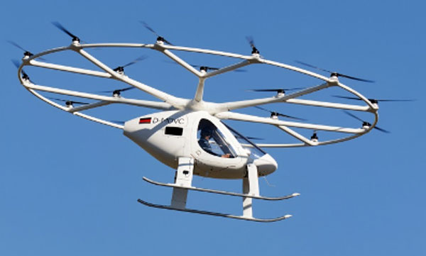
    Now TPA is a busy place, with 553 flights daily into and out of the facility, but Volocopter was able to fit into the infrastructure and perform two flight tests with the U.S. Federal Aviation Administration (FAA) to investigate aircraft downwash and outwash, along with aircraft performance in TPA’s actual environmental conditions.

    Various prototypes of the VoloCity have already flown 2,000 flights. Initial operational flights will be flown by a pilot with only one passenger. However, as operational reliability is proven, a fully autonomous service is planned. Volocopter is currently focusing on certification of the VoloCity, by the European Union Aviation Safety Agency (EASA) in 2024, leading to initial service on three routes in Paris, France. Concurrent validation in cooperation with the FAA, originally submitted in 2020, is also progressing.


    In conclusion, GNSS and communications jamming is escalating in and around Ukraine as the war drags on and each side tries to compensate, while efforts to revolutionize shuttle services for passengers to and from major airports in the United States has taken quite positive steps in Tampa, Florida.

  • Tampa demonstrates connected vehicle technology

    Tampa, Florida, took a big step toward its goal of becoming a smart city on Nov. 13, when the Tampa Hillsborough Expressway Authority (THEA) hosted its first public demonstration of connected car technology.

    THEA plans to equip 1,600 privately owned automobiles with connected vehicle technology by mid-2018 as part of the Tampa Connected Vehicle Pilot.

    In the project, volunteers’ automobiles will be equipped to communicate with downtown traffic and pedestrian signals to enhance safety, improve traffic flow and reduce emissions of greenhouse gases. Ten buses and 10 streetcars will also be equipped.

    Tampa is one of three sites deploying the technology as part of the U.S. Department of Transportation’s Connected Vehicle Pilot Deployment Program. The other two sites are New York City and the Interstate 80 corridor in the state of Wyoming. Tampa’s project is the only one that involves local residents driving their own cars.

    THEA is now recruiting volunteer drivers and pedestrians for the Tampa Connected Vehicle Pilot. Participating drivers commuting on the equipped expressway will receive a warning when traffic backs up, or when approaching a curve at an unsafe speed. Drivers who near pedestrians in certain crosswalks also will receive alerts.

    Pedestrians will be able to participate in the pilot by installing an app on their smartphones that will enable them to request a “walk” signal at certain intersections, and issue audible alerts if a bus or streetcar is moving nearby.

  • Live from ION GNSS+ 2015

    Live from ION GNSS+ 2015

    Tampa_Waterfront_O

    The GPS World staff reports live from ION GNSS+ in Tampa, Fla., September 14–18, providing news, photos, videos and more. GPS World will be there with a full team, including Editor and Publisher Alan Cameron, Managing Editor Tracy Cozzens, and our market-sector editors. We’ll be providing near-real-time coverage of the show on GPSworld.com and on Twitter.

    GPS World will also video record the indoor navigation demonstrations, and portions will be posted online at the GPS World YouTube channel.

    If you’re attending, be sure to come by the GPS World booth during the exhibit hall reception Wednesday evening to film a video-selfie with Mary Ann, our August cover great white shark. The video-selfies give you 30 seconds to tell us about yourself and will be posted to our YouTube channel.

    Check back throughout the week for updated information from the event.

    BLOGS

    Highlights from the Grand-Daddy of All GNSS Technical Conferences, by Tony Murfin (9/23)

    ION GNSS+ Plenary Navigates to Space, and Beyond, by Tracy Cozzens (9/16)

    ION GNSS+ Preview: UAVs, Indoor Location and a Shark!, by Alan Cameron (8/19)

    NEWS

    Broadcom Offers New GNSS Chip for Internet of Things (9/17)

    Unicore Releases GNSS High-Precision Board (9/17)

    UNAVCO Names Septentrio Preferred Vendor for GNSS Reference Stations (9/16)

    Septentrio Launches AsteRx-U and AsteRx-U MARINE (9/14)

    New Spirent Test Framework Evaluates Threats to GPS, GNSS (9/14)

    KVH Inertial Solutions Showcased at ION GNSS+ (9/9)

    Averna and Skydel Join for Demonstrations at ION GNSS+ (9/9)

    PCTEL to Offer Range of Antennas at ION GNSS+ (9/2)

    TAG’s Military Survey System on Display at ION GNSS+ (9/2)

    ION GNSS+: To Space and Beyond (8/3)

    ION GNSS+ 2015 Technical Program Available Online (4/8)

    VIDEOS

    Alan Cameron, GPS World editor and publisher, explains the importance of ION GNSS+.


    PHOTOS

  • ION GNSS+ Preview: UAVs, Indoor Location and a Shark!

    The Institute of Navigation (ION) GNSS+ conference is scheduled for Sept. 14-18 this year, just down the road in Tampa, Fla. It’s just over an hour’s drive for me, so I’ll be there again this year.

    The reminders from ION have started to show up in my inbox, touting issues like PNT privacy, a new UAV session, a return of the popular indoor navigation demonstrations with a significantly larger group of companies demonstrating, an update on what’s happening in indoor navigation regulation-land, and with a number ways to find out what’s happening on social media. So most GNSS industry people will now have their reminder to register, get a hotel room and choose the sessions they want to attend for their week in Tampa.

    GPS World will be there as usual with our full team, including our market-sector editors, along with near-real-time coverage of the show on GPSworld.com and on Twitter. The exhibition floor looks to be almost full, so if you were sitting on the fence thinking about exhibiting, its probably time to make a decision — there only appear to be a few booths still open.

    GPS World will also video record the indoor navigation demonstrations, and portions will be posted online at the GPS World YouTube channel.

    Also, come by the GPS World booth during the exhibit hall reception Wednesday evening to film a video-selfie with Mary Ann, our August cover great white shark. The video-selfies give you 30 seconds to tell us about yourself, and will be posted to our YouTube channel.

    The CGSIC (Civil GPS Service Interface Committee) meets and tutorials will be held on Monday and Tuesday, but the week basically gets going with the plenary session on Tuesday evening.

    James L. Green, director of Planetary Science for NASA.
    James L. Green, director of Planetary Science for NASA.

    This year, ION has called on Dr. James L. Green, director, Planetary Science at NASA, to give an insight into NASA’s interplanetary exploration over the last several years. He plans to take us “on a journey navigating our way through the Solar System showing you new worlds and new discoveries through the eyes of our planetary spacecraft.” In the last several years alone, the understanding of the origin and evolution of the solar system has changed dramatically. He’ll demonstrate how our foundations of knowledge have literally been reestablished.

    Technical papers and applications sessions get rolling bright and early on Tuesday morning.

    Then the exhibit hall opens up at 10 a.m. on Wednesday, with more than 50 GNSS and related exhibitors from around the world showing their new products and innovations. Exhibitors range from GNSS systems manufacturers to simulation, timing, engineering and system integrators, chip and receiver manufacturers, antenna and RF component suppliers, test-solution suppliers, indoor location experts, inertial navigation companies, government and R&D agencies, military and commercial GNSS suppliers, satellite system and component providers, survey-systems suppliers, and a smattering of Internet of Things (IoT) proponents. The exhibit floor runs Tuesday through Thursday in parallel with the applications presentations and panels and technical papers.

    The show floor at ION-GNSS 2014.
    The show floor at ION-GNSS 2014.

    Key application presentations for me to catch include the indoor location demonstrations on Wednesday afternoon, and the new UAV navigation session on Thursday morning. But there are around four parallel presentations on systems and applications and four sessions of technical papers each morning and afternoon Tuesday through Friday, so there are enough topics on a huge range of GNSS and related navigation technologies that would satisfy almost anyone in the industry or anyone wanting to learn about the industry.

    Indoor Location Demonstration

    The list of vendors who plan to demonstrate at the indoor location demonstration session is lengthy:

    • Nokia
    • InvenSense
    • RX Networks
    • Indoor.rs
    • Samsung
    • CSR
    • Combain
    • Pole Star
    • ByteLight
    • Microsoft

    That’s about twice as many participants as last year, when the audience was treated to a number of demos that worked, and some which basically didn’t. So, this is an opportunity to redeem themselves for those who had problems, time to update and show improvements over last year for the ones who demonstrated successful indoor navigation, and for the newcomers, we shall see what they have to offer. Hopefully, companies will have recognized that it’s essential to a have a large-screen display replicating handhelds for a large audience to follow what’s going on.

    UAV Session

    The UAV session appears to concentrate on alternate navigation and other sensors for unmanned airborne vehicles. Papers include modeling and calibration to remove magnetic biases coming from other devices on the platform; a kind of indoor navigation for micro-UAVs entering buildings for assistance in disaster conditions; navigation using optical imaging with and without GNSS; Stanford’s JAGER jammer detection project using DME and ADS-B signal navigation; and integrity requirements for UAV sense-and-avoid systems. Another panel session on Friday discusses integration of UAVs into the U.S. National Airspace System.

    If these couple of topics don’t fire you with enthusiasm, don’t worry – there are masses of other great topics to pick from in the extensive technical program at ION GNSS+. Right now, pre-registration for ION GNSS+ is running 26 percent ahead of where it was last year, so we could have 1,300-1,400 technical attendees this year.

    So, come on down to Florida – yes, it’s warm (the Convention Center is air conditioned), but its not too warm — even for a guy like me from the frozen North!

    Tony Murfin
    GNSS Aerospace

  • ION GNSS+ 2015 Technical Program Available Online

    The ION GNSS+ 2015 technical program is now available online, and registration is open.  ION GNSS+ 2015 will be held Sept. 14-18 (tutorials Sept. 14-15) at the Tampa Convention Center, Tampa, Fla.

    This year, unlike in previous years, the technical program (registration brochure) will only be distributed online. Users can search and sort the program online or download and print a PDF version. A printed on-site guide book will still be available to attendees.

    ION GNSS+ 2015 is the 28th International Technical Meeting of the ION Satellite Division and the world’s largest technical meeting and showcase of GNSS technology, products and services and other sensors in today’s marketplace.

    Attendees who book a hotel room first will save $200 by entering the hotel confirmation number from the Tampa Marriott Waterside Hotel and Marina at the start of the registration process. Attendees will need a valid hotel confirmation number to claim this discount during registration.

    ION GNSS+ brings together international leaders in GNSS and related positioning, navigation and timing fields to present new research, introduce new technologies, update current policy, demonstrate products and exchange ideas. The focus of this meeting is the growing emphasis on GNSS and the rapidly evolving field of alternative navigation methods.

    This year’s conference will feature panels of industry experts, policy updates, the world’s largest GNSS commercial exhibit and more than 300 technical presentations presented through:

    Peer-Reviewed Tracks

    • Multisensor Navigation and Applications
    • Algorithms and Methods
    • Advanced GNSS Technologies

    Systems and Application Tracks

    • Mass-Market Applications
    • High Performance & Safety-Critical Applications
    • System Updates, Plans and Policies

    GPS World Editor and Publisher Alan Cameron discusses the importance of the annual ION GNSS Conference at the 2014 event, also held in Tampa.

  • Esri Launches Site to Find Open Data

    ArGIS-Open-Data-W

    Esri has launched a website to help citizens discover organizations sharing open data around the world and provide direct access to thousands of open government datasets. Citizens can search, download, filter, and visualize this data through their web browser or mobile device.

    Since July 2014, more than 1,200 organizations from all levels of government, including the National Geospatial-Intelligence Agency (NGA), and the cities of Raleigh, North Carolina; Tampa, Florida; Charlotte, North Carolina; and Muroran, Japanhave used Esri’s ArcGIS Open Data to configure custom open data sites to serve local citizens and businesses. Now the public can search across these sites to find authoritative data by location and topic.

    “We are excited about the large number of organizations currently sharing open data and believe we have a great opportunity to boost global support for open data and open knowledge,” said Andrew Turner, CTO of Esri’s DC R&D Center. “As more of the 380,000 organizations we work with across the globe begin to contribute open data, we will be able to help foster innovation by connecting the millions of datasets created by government agencies and shared through ArcGIS Open Data.”

    Any organization can make its data available through ArcGIS Open Data, and people can now discover this data by visiting opendata.arcgis.com.

  • GeoEye Expands Tampa Office to Address the U.S. Military’s Growing Demand

    GeoEye, Inc. announced the expansion of its Tampa office to support the growing demand for its services across the U.S. military. This growing presence builds on the tremendous success GeoEye customers have had using its advanced analytic assessments to discover geospatial patterns that allow our warfighters and allies to find and thwart adversaries around the globe.


    According to the announcement, Tampa is the headquarters for the United States Special Operations and Central Commands and home to other U.S. military organizations. In addition to supporting its U.S. military customers there, GeoEye considers Tampa to be an attractive area to recruit data scientists, geospatial analysts and other technical talent motivated to safeguard our most pressing national security interests.

    GeoEye reports that the office in Tampa is one component of a virtual analytics center of excellence that will aggregate and analyze unclassified imagery and open source data to predict areas where threats are more likely to emerge across Africa, Asia and other parts of the world.  Using these resources GeoEye Analytics recently analyzed patterns of the Lord’s Resistance Army (LRA) in Central Africa identifying its operating behavior and area preferences which predicted areas of concern that matched where key LRA leadership was recently apprehended.

    Matt O’Connell, GeoEye’s chief executive officer and president, commented, “GeoEye Analytics has become a critical part of our business. Last year, our analytics team brought GeoEye two of its top 10 customers. We’ve seen a steady increase in the demand for geospatial analytical support to intelligence agencies and Combatant commands who manage global threats. We think this demand is defined in the Defense Budget guidance that reflects a growing need for our solutions. Building and deepening analytic expertise has also been noted as a top priority by our intelligence customers.”

    Alex Dunmire, senior program manager of the Tampa office, added, “We combine earth imagery, geospatial expertise, and enabling technology to help intelligence analysts, military planners and law enforcement personnel who need a deep understanding of our changing world to protect lives and make confident resource allocation decisions. Our predictive analytics capability has clearly made a difference for our clients and we’re looking forward to new opportunities to contribute to our Nation’s public safety and national security requirements.”