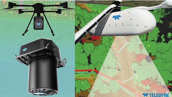
Teledyne Optech will showcase its portfolio of solutions designed for topographic and marine mapping and electric utility inspection at Intergeo 2025, taking place Oct. 7-9 in Frankfurt, Germany. The company will exhibit at Hall 12.0, Stand 0C067.
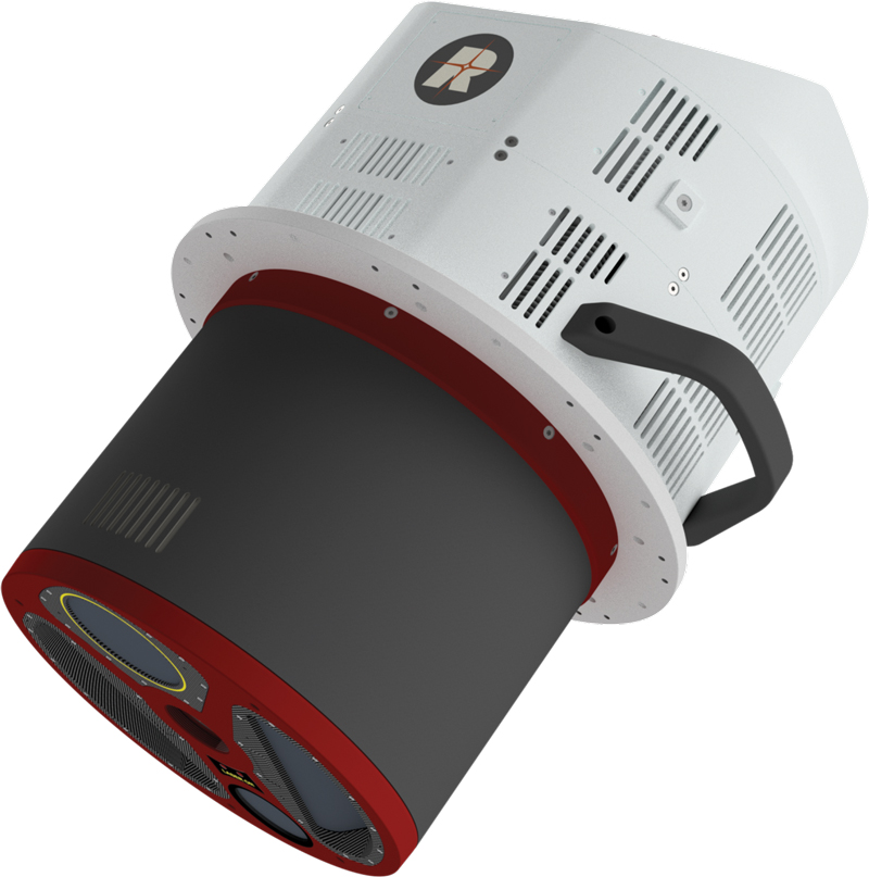
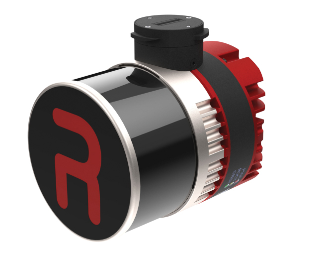
Featured technologies will include Fathom, a topo-bathymetric airborne lidar system designed for data integration of topo lidar, bathy lidar and a multispectral camera capturing the coastal scene from dry land to below water. Also on display will be EchoONE, Optech’s smallest lidar sensor to date at just 1.65 kilograms, combining long-range performance with NDAA compliance and real-time generation of georeferenced point clouds. Visitors will also see Network Surveyor, powered by Galaxy Edge and designed to meet the time constraints of electric utilities, featuring real-time processing and a software analytics stack for utility operators.
Visitors are invited to view a new compact lidar sensor designed for integration in modern wing and belly pods. Deployable in lightweight aircraft and helicopters, the sensor delivers high resolution for mapping projects, utility asset management and vegetation monitoring. Teledyne Optech will host a reception Tuesday, Oct. 7, from 4-6 p.m. at the stand.
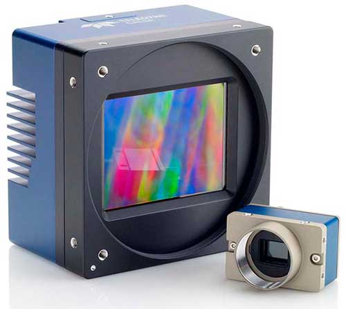
The booth will also showcase Teledyne Marine’s sonar and software solutions for marine infrastructure projects, including dredging, offshore wind and port and harbor operations. Live demonstrations of Teledyne FLIR IIS’ spherical imaging camera Ladybug 6, with spatial accuracy of plus or minus 2 millimeters at 10 meters distance, will be available.
Mike Lee, director of product management at Teledyne FLIR IIS, will speak Tuesday, Oct. 7, from 12:50-1:10 p.m. on “Beyond Resolution: Advancing Mobile Mapping Through Spherical Imaging Innovation.”
Teledyne Optech is a lidar solutions provider. With operations and staff worldwide, Teledyne Optech offers solutions for topographic and marine mapping, defense and electric utility inspection.
A roundup of recent products in the GNSS and inertial positioning industry from the December 2024 issue of GPS World magazine.
Mapping
Photo: SPH Engineering
GPR System For terrestrial and airborne applications
The Zond Aero 500 NG is a versatile ground penetrating radar (GPR) system designed for both terrestrial and drone-mounted surveys, suitable for applications such as utility scanning, sinkhole detection, glaciology and geological studies. It operates in dual mode, allowing for ground-based and airborne surveys, enhancing data collection flexibility. Key specifications include a center frequency of 500 MHz, an operating bandwidth of 200 MHz – 900 MHz, a sampling rate of 25,600 samples per second and a scan rate of 50 scans per second, with depth penetration up to 4 meters in average soil conditions. The system features advanced electronics for real-time data collection, which can significantly improve the signal-to-noise ratio. It is compatible with DJI Matrice 300/350 UAVs for airborne applications.
Streamlined Lidar Mapping YellowScan’s Surveyor Ultra integrated with DeltaQuad Evo
Integrating YellowScan’s Surveyor Ultra with the DeltaQuad Evo platform allows users to collect high-precision, high-density data across 1,200 hectares in a single flight while simultaneously capturing lidar and RGB data.
DeltaQuad Evo’s long-range flight capabilities and efficient vertical take-off and landing (VTOL) design, paired with the Surveyor Ultra’s lidar technology, allow users to streamline their workflows to reduce time spent in the air and on post-processing tasks, making it particularly beneficial for large infrastructure projects, forestry analysis and environmental monitoring. The system can be used for surveying, construction, forestry and environmental research.
Airborne Mapping System With a ‘cross-fire’ scan pattern
The VQ-1560 III-S is a dual-channel laser scanning system designed for airborne mapping applications. Its “cross-fire” scan pattern allows for simultaneous forward and backward viewing at the edges of the swath, along with a nadir view in the center. This configuration optimizes point distribution for effective target sampling. With pulse repetition rates reaching up to 4.4 MHz, the VQ-1560 III-S can operate at altitudes of up to 1,600 m above ground level (AGL). At a lower pulse repetition rate of 560 kHz, it can function at altitudes as high as 3,900 m AGL.
The system features inertial measurement unit (IMU) and GNSS integration, with the option to include one or two high-resolution RGB/NIR cameras. It is ideal for professionals in fields such as urban planning, forestry and environmental monitoring.
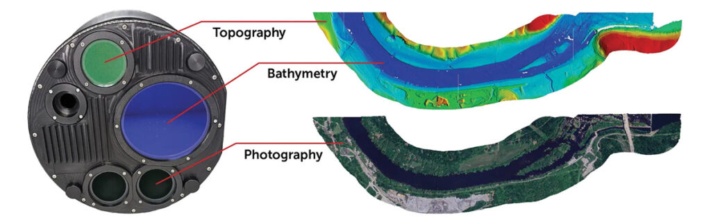
This bathymetric lidar system is designed for coastal and inland water mapping. It combines high-resolution topographic and bathymetric capabilities, allowing for seamless data collection across land and sea. It can be used for coastal zone management, environmental monitoring, infrastructure planning and more.
Fathom delivers data quickly by leveraging real-time quality control with Onboard and scalable processing with a CARIS workflow. It also includes a built-in topographic lidar and a multispectral camera for coastal surveys at a coverage of 50 km2/hour.
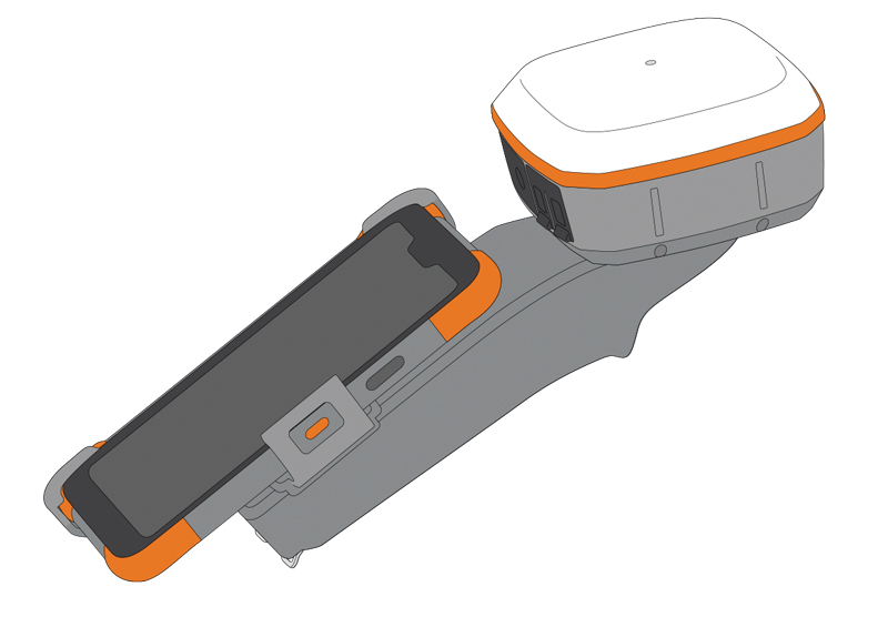
The Geode Grip is a mounting accessory featuring a specialized bracket. It allows users to securely attach smartphones directly to Juniper’s Geode GNSS receivers, offering an integrated and streamlined data collection solution.
The Geode Grip is a tool designed for professionals in surveying, mapping and geographic information systems (GIS) to enhance mobile data collection. It replaces the traditional survey pole with a handheld setup that aims to improve ergonomics. It is ideal for field projects that require precise location data and mobile data collection, such as environmental research, land surveying, agriculture and infrastructure engineering.
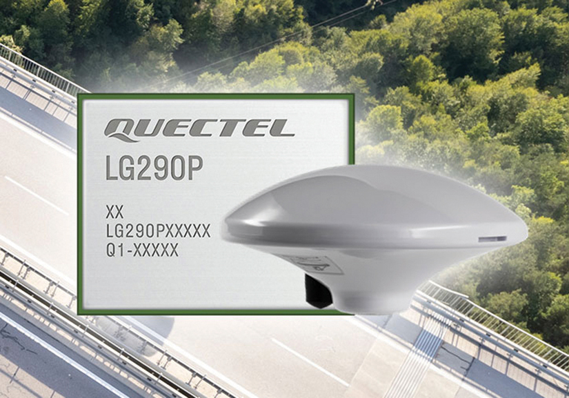
New Product Bundle For high-accuracy GNSS applications
Quectel Wireless Solutions has unveiled a new product bundle designed to facilitate the development of high-accuracy GNSS applications. The bundle includes the LG290P GNSS module, which is a quad-band, multi-constellation device capable of receiving signals from various satellite systems, including GPS, GLONASS, Galileo, BDS, QZSS and NavIC. The LG290P is engineered for high precision and supports RTK positioning, allowing for centimeter-level accuracy even in challenging environments. It can be used in diverse applications, such as autonomous vehicles, precision agriculture and surveying.
In addition to the LG290P module, the bundle includes options for either the YEGN103W8A geodetic antenna or the YEGD006U1A patch antenna. Both antennas are designed to operate within the same frequency bands as the GNSS module and are compliant with environmental regulations such as RoHS. This pre-integrated solution simplifies developers’ procurement and integration process by providing a one-stop solution that combines antennas with GNSS modules and RTK correction services.
Lidar Camera Payload For surveying and mapping applications
The RESEPI Ultra LITE is a lightweight payload combining lidar and camera technology for advanced surveying and mapping applications. The system integrates the XT-32 lidar scanner to offer users advanced data accuracy and point density across various operational modes.
It has a compact design with a 5MP colorization camera, making it ideal for small unmanned aerial systems (SUAS) with strict volume constraints. It can be used for aerial and ground-based applications, including utility mapping, construction volumetrics, precision agriculture, forestry, site surveying and mining. Designed for seamless integration, the system is compatible with a wide range of platforms such as Freefly, WISPR, DJI, Sony and mobile setups. Inertial Labs’ proprietary SnapFit adapters ensure quick and secure mounting to enhance the system’s adaptability.
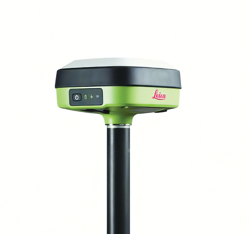
The Leica GS05 is a compact and lightweight GNSS smart antenna designed for surveying tasks, featuring calibration-free tilt compensation. This robust device allows for accurate measurements even when the survey pole is tilted up to 30°, enhancing data collection in challenging environments. Its integration with Leica Geosystems’ portfolio, including Leica Captivate software and total stations, seeks to maximize efficiency. The GS05 can function as both a base and an RTK rover, supporting single base stations and RTK networks such as Leica SmartNet.
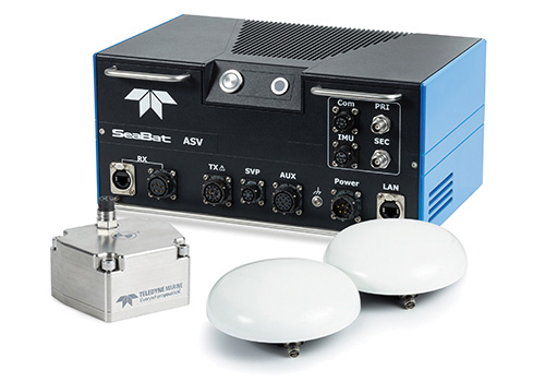
Intrepid is a GNSS/INS system integrated with the SeaBat T20-ASV processor and includes a compact IMU and two GNSS antennas, ensuring reliable and precise positioning.
It can automatically stream data to third-party software. This eliminates the need for manual sensor interfacing and reduces downtime. The Intrepid GNSS/INS benefits users in marine surveying applications by providing the precise navigation necessary for operational efficiency. Its intuitive design allows for simple configuration.
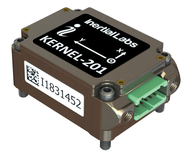
Miniature MEMS Sensor-Based IMU Can withstand high shock and vibrations
The KERNEL-201 features three-axis MEMS accelerometers and gyroscopes that offer ultra-low noise, high bandwidth and minimal latency. These characteristics make it ideal for applications such as pointing, stabilization and navigation in systems where performance and size are critical. Its volume of 0.38 cubic inches offers a high dynamic range.
Fully calibrated and temperature-compensated, the unit offers consistent, precise measurements even in challenging environments. It features an in-run bias stability of up to 0.7 deg/hr for gyroscopes and 0.005 mg for accelerometers, along with a low angular random walk (ARW) of 0.065°/√hr and velocity random walk (VRW) of 0.015 m/sec/√hr.
The unit is designed to withstand high shock and vibration while maintaining peak performance, making it suitable for a wide range of challenging applications. The KERNEL-201 can be integrated into various high-level systems, such as motion reference units (MRUs), GPS-aided inertial navigation systems (INS) and attitude and heading reference systems (AHRS). It offers continuous built-in testing (BIT), customizable communication protocols and flexible power options.
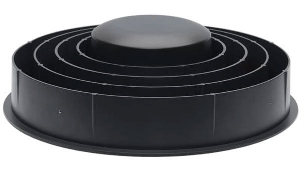
Smart Choke Antenna Offers comprehensive GNSS signal reception
The VCS6000XF full band smart choke antenna is engineered for CORS applications. It combines Tallysman Verachoke antenna elements with Septentrio’s Mosaic X5 full-band receiver to offer an integrated solution for OEM CORS systems.
The VCS6000XF offers comprehensive GNSS signal reception, including GPS/QZSS L1/L2/L5, GLONASS G1/G2/G3, Galileo E1/E5a/E5b/E6/E5 AltBoc, BeiDou B1/B2/B2a/B3, NavIC L5, SBAS and L-Band correction services.
The antenna features a 0.5 mm phase center variation and utilizes Calian’s eXtended filtering for near-band signal interference mitigation. The integrated Septentrio Mosaic X5 receiver provides capabilities such as anti-jamming, anti-spoofing, scintillation mitigation and receiver integrity by combining the antenna and receiver in the choke ring antenna.
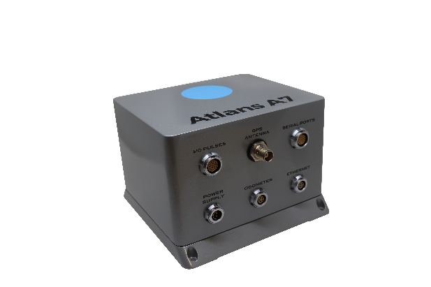
Oceanographic & Geophysical Instruments (OGI) has selected iXblue’s Atlans INS to provide robust and uninterrupted data georeferencing to its newly unveiled mobile-mapping lidar solution dedicated to road assessment surveys.
A fully integrated mobile mapping solution, this new vehicle-based system integrates advanced systems to provide highly detailed georeferenced survey data to transportation departments throughout the United States.
“Highly accurate and reliable georeferencing of the collected data being crucial for road assessment operations, we were seeking a compact and robust navigation solution for our mobile scanner project,” said Darren Moss, program manager at OGI. “We tested other inertial navigation systems (INS) during mobile surveys in New York City and Boston with poor results, as those INS units relied mainly on GPS signals. Maintaining good GPS signals in the urban canyons of large cities proved to be impossible. This deeply impacted the georeferencing of the acquired lidar data, leading to highly inefficient operations. This is the reason we turned to iXblue’s Atlans A7 INS.”
Based on fiber-optic gyroscope (FOG) technology, the Atlans A7 north-seeking INS offers highly accurate and robust data georeferencing. Resistant to GPS outages, it enables continuous acquisition operations within environments lacking continuous GPS signals. The Atlans A7 is a valuable system for high-accuracy data acquisition without interruption.
“Working with iXblue in other markets, we were familiar with the high-quality instrumentation they are known for. We were confident their FOG-based INS systems would perform even during GPS outages,” Darren said. “By choosing the Atlans A7, we are assured to get robust and uninterrupted georeferenced data in urban environments, tunnels, forests, and mountainous areas, which is crucial for our customer’s operations. With this INS, iXblue brings high-end FOG performance to the mobile-mapping industry at a very affordable price.”
“The Atlans A7 integrates very well within our new mobile lidar solution and, combined with Teledyne Optech Polaris high-resolution lidar scanner and QPS Qinsy display and acquisition software, it brings high-accuracy and efficiency to the core of our Mobile lidar solution,” Darren said.
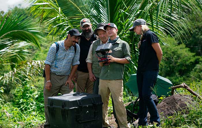
PrecisionHawk’s Jaymie Young and Matt Tompkins fly a UAV with the hosts of History Channel’s “Lost Gold of World II” in the Philippines in late 2018. (Photo: PrecisionHawk)
The collection of about 300 giant geoglyphs known as Nasca Lines were etched into the ground in the Peruvian coastal plain 2,000 years ago by the Nasca culture in South America. They depict various plants, animals, and shapes and are so large that they can only be fully appreciated when viewed from the air. Unlike the Nasca Lines, most archaeological sites are hard to see from the air, especially those deep under thick jungle vegetation, as in the lowlands of northern Guatemala. Here, lidar’s ability to penetrate foliage makes it the ideal tool for archeological exploration. At the same time, the lack of infrastructure, including airports, makes UAVs the platform of choice for many such projects.
Challenges for lidar in archaeology
Operating aerial lidar for archaeology in a jungle environment presents four challenges. The biggest one is penetrating the canopy. “Typically, the sites that they have been exploring lately have been quite overgrown, and disguising what has been there for a long time, to the extent that even someone walking on the ground has not been able to see the scope of the site,” said Paul LaRocque, senior scientist at Teledyne Optech. Penetrating multiple layers of vegetation requires a minimum of two lidar returns. For heavily vegetated environments, Matt Tompkins, director of Flight Services at PrecisionHawk, recommends a five-return system.
The second challenge is ground-truthing the data collected, explained Thomas Garrison, assistant professor in Ithaca College’s Department of Anthropology. “Even though we digitally removed the forest, it is still there, of course.” For example, it is hard to confirm long roads between sites, because they run beyond a ground observer’s field of vision.
The third challenge is acquiring a GPS signal. “In the tropical environment, a UAV needs to return to its take-off site very precisely,” Garrison explained. Finally, jungles put a twist on the familiar trade-offs between fixed-wing and rotary-wing UAVs: “A fixed-wing UAV will cover a greater area, but you may not have enough space for it to take off where you want to fly your lidar and may not be able to recover it,” Garrison said.
Making lidar an effective tool for archaeology required the development of sensors with very high pulse repetition frequencies (PRF) and with multi-look angles, which better penetrate the canopy to reach the ground and any structures, LaRocque explained.
Manned aircraft vs. UAVs
Archaeology missions need aerial lidar sensors with sufficient peak power from each pulse to reach the ground after much of it is absorbed or reflected by the canopy. In this respect, manned fixed- and rotary-wing aircraft have an advantage over UAVs because they can carry larger sensors with a higher peak power. Plus, they can cover much larger areas per flight. “This is important because archaeologists have been finding that [areas of interest] are much bigger than they ever imagined,” LaRocque said.
Finally, forests and jungles make it challenging to find open areas for launching and landing UAVs and flying them by line of sight. “Where do you stand to see the UAV above the canopy?” For these applications, LaRocque said, manned aircraft probably fly just 500 to 1,000 meters above ground level, “because they are not out for high survey efficiency but for penetration to the ground.”
Tompkins, whose company has conducted many missions in jungle environments and other remote places, takes the opposite view. Archaeology constantly presents new challenge and “takes you to some pretty crazy places,” he said and UAV lidar “allows archaeologists to access information that would otherwise be too difficult or dangerous to access.” In the projects on which PrecisionHawk has worked in heavy jungle, it has seen “excellent penetration through heavy jungle canopy, which gave us access to ground-level data,” he said.
Logistically, Tompkins pointed out, UAVs are “significantly easier and safer than manned aircraft” in remote areas with little access to airport infrastructure, air traffic control, and any sort of emergency services. A team with a UAV can mobilize and travel quickly. Where there is no electricity to recharge the UAV’s battery, the team will bring a generator.
Positional accuracy
Archaeological applications do not require survey-level positional accuracy. Archaeologists only need to be able to locate on the ground features that they identify in the 3D lidar point cloud. “We use Trimble Juno 5s, so that we can load the lidar data directly onto their screens,” Garrison said. “If we get near a structure, we only need to take a point. We don’t even need to find base stations and do corrections afterward. We can manually correct the points based on where they were on the structures.”
Ancient structures are rarely in the areas with the thickest, nastiest vegetation, which are usually low-lying areas, Garrison said. However, those areas might reveal other items of cultural interest, such as agricultural fields. “In the lidar data we have, we are seeing that ancient societies were terraforming their entire landscape, so everywhere you go there is something to check or confirm.”
Missions
In 2018, PrecisionHawk conducted an archaeological project in a remote jungle in the Philippines for a History Channel show called “Lost Gold of WWII.” Show producers were trying to find where Japanese troops might have stored gold stolen from the Philippine government.The team flew lidar on a UAV to identify roads or other manmade structures that could help them identify possible hiding spots in areas pinpointed through historical documents, Tompkins recalled.The PrecisionHawk team produced a colorized lidar data file in the jungle that the producers used on the program.
The largest lidar acquisition for archaeological investigations in the world is the Pacunam Lidar Initiative (PLI), a consortium of scholars funded by the Guatemalan foundation Pacunam (short for Fundación Patrimonio Cultural Y Natural Maya). So far, the PLI has scanned about 7,000 square kilometers in the lowlands of northern Guatemala.
Garrison is one of three principal consultants for the foundation. “Lidar has a huge impact in archaeology under tropical forests because you get more bang for the buck in terms of peeling back the forest and revealing the preserved ancient landscapes underneath,” he said. “We’ve been working on these data since we first flew in 2016 with the National Center for Airborne Laser Mapping in Houston. We published preliminary results in Science in 2018.” In the massive PLI project, “Instead of just single sites, we can see broad trends across huge areas.”
The first phase of the Pacunam lidar initiative covered 2,100 square kilometers in northern Guatemala in 10 different polygons of data acquisition. “We found that there were 60,000 more structures in these areas than we knew about before,” Garrison said. This raised the question of how so many people could feed themselves. The lidar data revealed that they had used huge swampy areas as agricultural fields. It also revealed many road systems between and within these sites and many defensive earthwork features of military engineering for warfare distributed along the valleys.
“All of that changed our view of what this ancient landscape looked like,” Garrison said. In the summer of 2019, the project flew another 5,000 square kilometers and is now analyzing the data, which shows “a complete picture of an ancient culture’s impact on the landscape,” Garrison said. “When you think of ancient Rome and everything that they had, you can’t really see everything because modern Europe is there. But here we have all this stuff preserved under the jungle in a way that is letting us see the totality of an ancient culture.”
Discoveries made with UAVs
• Using UAV lidar, the Crow Canyon Archaeology Center and the Canyons of the Ancient National Monument were able to map an 800-year-old Pueblo site at Sand Canyon, Colorado, and discover previously undocumented structures. UAV experts from Caddis Aerial and Routescene conducted the survey using a Velodyne HDL32 lidar scanner on a DJI M600 Pro UAV flying at 40-meter altitude relative to the take-off point. They then processed the point cloud, consisting of 3.2 billion points, using Routescene’s LidarViewer Pro software and created a digital terrain module at 400 points per square meter.
• A hexacopter built with DJI technology, flying 20–60 meters above the ground, enabled Isabelle Heitz of AirD’éco to map several ancient sites, including the microtopography of an ancient theater covered by woods in the center of Soissons, a town in eastern France, and a fortified town of the Gallic age, now covered by thick woods.
• Using Google Earth, satellite imagery and low-flying UAVs, archaeologists Sarah Parcak and Christopher A. Tuttle discovered a previously unknown monumental structure that had been hidden in plain sight only half a mile from the World Heritage site of Petra, Jordan.
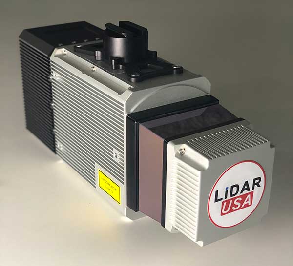
The Snoopy CL-360 lidar scanner. (Photo: Lidar USA)
The Optech CL-360 has joined the ranks of Lidar USA Snoopy systems.
The Snoopy CL-360 has been meticulously designed for integration on backpack, vehicle and UAV applications. Weighing 5 kilograms fully assembled, the Snoopy CL-360 is capable of delivering highly accurate results, up to +/-0.01 feet on paved surfaces from a vehicle.
The system has a scan line rate of 250 Hz with a 500-kHz data rate, giving a uniform result along and across track. The systems are easily configurable with multiple scanners (similar to internet of things applications) to avoid occlusions.
“We are pleased to again partner with LidarUSA in their innovative approach to UAV integration with the addition of our CL-360 to their product portfolio. Featuring true 360-degree scanning without blind spots, CL-360 integrated by LidarUSA will provide an exciting addition to the UAV marketplace,” said Optech Executive Vice President and General Manager Michel Stanier.
Users can also benefit from a UAV deployment, achieving scans with usable data as much as 60 degrees off nadir (widths of more than 1,100 feet while scanning at the 400-foot ceiling). The small beam size of 0.3 mrad allows the CL-series to reliably collect ground points (such as on or near the dirt through vegetation) while also providing better detection of fine linear features such as power lines and railroad tracks.
The integration of the CL-360 into the Snoopy series of systems from Lidar USA is expected to be a huge plus to the mapping community in 2020, according to Lidar USA. Users can expect to see the benefit of decreased field-collection effort and increased product quality resulting in a growing and profitable business.
“As more technologies embrace lidar collection to reduce their field time, we expect to see the CL-series become the ‘go to’ solution for many of them,” said Jeff Fagerman of Lidar USA. “The CL-series provides the accuracy and point density often necessary to meet the client’s every growing demands for more, more, more. By designing the system for car and UAV, as well as multiple configurations (two or more systems running together), our users will greatly benefit where they feel it most — the bank.”
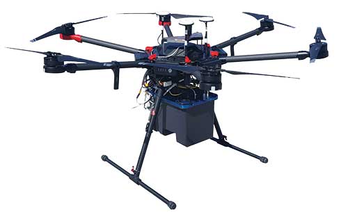
Teledyne Optech’s new compact lidar sensor, the CL-90, is available for purchase through its first integration partnership with Lidar USA.
For more than 20 years, Lidar USA has been building UAV sensor systems and has sold thousands of systems worldwide. Its ability to support numerous industries with cutting-edge integration makes them an ideal partner for Teledyne Optech’s compact lidar sensors, Teledyne stated in a press release.
Lidar USA’s products are used for surveying-related tasks ranging from topography work, to highways and land development. They are also used for agricultural work for forestry and plant growth, and have applications in archeology as well.
Teledyne Optech’s CL-90 sensor features exceptional canopy penetration for excellent ground coverage, higher downward point density for superior results in corridor/power line projects, long-range performance for maximum productivity at UAS ceilings and best-in-class data precision for tight-tolerance applications, the company said.
“Our customers face many challenging projects and they need tools that can deliver,” said Lidar USA CEO Jeff Fagerman. “Whether it’s greater range, more accuracy or better penetration of vegetation, using the new Optech CL-90 gives us the means of providing the tool to get the job done.”
Teledyne Optech Executive Vice President and General Manager Michel Stanier believes the partnership will help expand both companies’ global presence.
“Teledyne Optech is pleased to partner with Lidar USA to bring our compact lidar sensors to market,” Stanier said. “Lidar USA is a premier UAV solution provider. As a result, we are confident that their integration expertise and strong global market presence will provide the ideal platform to deploy the CL-90’s rich, unique feature set into the UAV marketplace.”
Lidar USA will be at Intergeo this year and can be found at ICS Foyer Stand 2 featuring a fully integrated CL-90 solution. Teledyne Optech will be featuring some of its new Compact Lidar suite of products this year at Intergeo Booth B3. 042 from September 17-19 in Stuttgart, Germany.
Teledyne Optech, Teledyne DALSA and Teledyne Scientific & Imaging, all part of the Teledyne Imaging group, will share a combined presence at Booth #2520 at the AUVSI Xponential 2019 show in Chicago April 29-May 2.
The three companies will showcase their new and advanced sensor and imaging solutions.
Teledyne Optech presents a new compact lidar family, the CL-90. Attendees can preview the lightweight, compact lidar platform for UAV deployment. The CL-90 features exceptional canopy penetration, offering the low-noise, high-quality survey-grade data to deliver extraordinary performance in data accuracy and point precision.
The CL-90 empowers full lidar performance across the entire operating altitude range of the UAV, and offers an exclusive variable field-of-view capability eliminating the need for multiple passes over a target.
Teledyne DALSA will showcases its advanced thermal and visible cameras. The Genie Nano family of low-cost area cameras for UAVs are lightweight, power-efficient and compact.
The Falcon 4 86-megapixel ultra-high resolution and high-speed CMOS camera offers capabilities for large-area, high-resolution, high-speed imaging.
The Calibir series of long wave infrared (LWIR) cameras deliver compact, low-profile thermal solutions, designed for UAV applications such as agriculture, construction, defense and surveying. Calibir is customizable with smart embedded algorithms and capability for real-time VIS-LWIR image fusion.
Teledyne Scientific & Imaging features a new artificial intelligence (AI) software stack capable of real-time performance on board UAVs. The AI stack enables automatic sensor processing for applications such as sensor fusion, asset recognition and tracking, and adaptive dynamic range for deployment in daytime and variable light operations.
Reflecting the dramatic changes and advances that have taken place in the applications of positioning technology over the last decade, the plenary session of the 37th meeting of the Institute of Navigation’s Satellite Division did not discuss satellites at all. Instead, two keynote speakers elaborated upon the application of positioning to emergency response services and to airborne mapping with lidar technology.
Emergency Location Service (ELS) in Android
Steve Malkos, technical program manager at Google, told the audience of approximately 800 that the new emergency location service “is our passion project at Google. Just last week we announced the expansion of ELS into the U.S. It’s here and it’s ready today. But the work isn’t done yet because of various challenges.” Google’s goal is 1-meter location accuracy for all 911 calls placed on cell phones. The algorithms discussed at ION this week, Malkos said, are part of what is driving Fused Location Provider (FLP)
toward this future.
In FLP, locations are computed directly on the handset as opposed to the older method, which computes on the carrier’s cell network. Google’s indoor solution consists of wi-fi augmented by network information.
Recently released statistics show emergency call usage has flipped from what it was only a decade ago. Now, only 20 percent of emergency calls are placed on landlines. Eighty percent are placed on wireless devices.
Malkos replayed audio from a call made recently, prior to activation of ELS, that generated a location on Miami’s emergency services of 500 meters away from the basement ballroom of the conference hotel.
Domino’s Pizza, Uber ride service and Facebook all now use the hybrid derived location from cell phones, while emergency services typically use the location computed on the carriers’ network, and relying on cell-tower positioning. Cells range from 100s of meters to kilometers in size.
ELS has been live in the U.K. since June 2017. Since its activation, British Telecom’s mean radius accuracy on emergency calls went from 2 kilometers to 43 meters 85 percent of timeION20.
Malkos discussed the challenges of privacy, altitude (Z-axis) and the related difficulties in the urban high-rise landscape of floor determination and infering floor labels.
Overall, he said, statistics show that each 1 minute sooner of arrival of emergency services translates to 10,000 saved lives.
A Lidar History
Paul LaRocque, vice president of special projects at Teledyne Optech gave an overview of light detection and ranging (lidar) development through the lens of a one-company centric history, that of Teledyne.
Lidar got started in 1969, within a decade of the invention of the first laser. It began with early work in marine mapping and bathymetry from onboard ships. Airborne lidars developed in the late 1970s, looking at icefields in the Arctic, and was done at first with no absolute positioning to aid in analyzing the results..
Early on, developers discovered that airborne lidar can get to the bare earth, penetrating under forest canopy. This eventually led to the recent dramatic discoveries of long lost Mayan cities, covered by jungle.
In the early 1990s, GPS and inertial technologies converged, with some miniaturization, to enable building of integrated technology systems that added absolute positioning to the lidar toolbox.
LaRocque provided a quick look at the National Geographic story, based on data from a three-wavelength Teledyne Optech Titan, one of several current machines that are generating data at millions of shots per second. Increasingly, it’s the software processing that brings out the accuracy, for example, centimeter accuracy surveyed from a kilometer up in the air.
Challenges enumberated:
the speed of light is not fast enough.
the Earth is not flat enough.
Teledyne developed PulseTRAK technology to cope with the “blind zones” generated by these two challenges, so as to not lose data in any gaps.
The new frontier is spaceborne lidars. Teledyne is involved in a project tenerating lidar data from the surface of Mars on a Canadian space agency mission. This led previously to the discovery of snow in the atmosphere of Mars. The OSIRIES-Rex mission now on its years-long voyage to a very-far off asteroid represents the furthest adventure of lidar in space. The project will collect data on the asteroid’s surface and beam it back to Earth, as well as eventually returning some core samples.
Steve Malkos of Google, and a GPS World contributor, will address the ION GNSS+ plenary session at the technical meeting and showcase, to be held Sept. 24-28 in Miami.
Malkos will address “Emergency Location Service in Android.” When emergency services get a call, they need to know the caller’s location to send help and save lives. More than 80 percent of calls to emergency services come from mobile phones, but locating these mobile callers can be a major issue.
Current emergency solutions rely on cell tower location (which can have a radius of several kilometers) and, in some countries (like the U.S. and Japan), on A-GNSS. But A-GNSS can fail with weak signal reception, in urban canyons and indoors.
Malkos will discuss how Emergency Location Service in Android is delivering more accurate location (computed from fusion of Wi-Fi, cell, GPS and sensors) to emergency services when an emergency call is detected.
Paul LaRocque
Also speaking is Paul E. LaRocque, Teledyne Optech‘s vice president of Special Projects. In his presentation, “A Lidar History: From Ship to Air to Space,” LaRocque will give a historical review of the airborne laser mapping systems that Teledyne Optech has designed and built over the years.
Optech has been active in laser radar systems beginning with marine lidars and later moving to airborne and spaceborne systems. Navigation has been an important subsystem in these developments, and its role will be described as part of this story.
LaRocque has been involved in the development of Optech’s lidar systems since the late 1980s. Dr. LaRocque was instrumental in the design of Optech’s airborne lidar bathymeters, airborne lidar terrain mappers (ALTM), and waveform digitizers, as well as other special lidars.
Teledyne Optech will exhibit at the United States Geospatial Intelligence Foundation’s GEOINT Symposium April 23-25 in Tampa, Florida.
Technology partners from Teledyne Scientific & Imaging, Teledyne DALSA and Teledyne CARIS will exhibit together as part of Teledyne Imaging – Space & Defense in booth 1148.
At GEOINT 2018, visitors can discover the advanced capabilities of the Optech Galaxy PRIME, the latest model of Teledyne’s Galaxy airborne laser terrain mapper, with enhanced range performance, collection efficiency, vegetation penetration and low-reflectance target detection.
The Polaris Terrestrial Laser Scanner (TLS) will be on hand so that visitors can experience its highly automated and user-friendly interface and see its performance at ranges from 1.5 to more than 2,000 meters.
In addition, attendees can learn about the Optech Maverick, the company’s first wearable mobile-mapping system that fits on a backpack.
The Teledyne Imaging – Space & Defense initiative brings together the experience and capabilities of Teledyne Optech, Teledyne Scientific and Imaging, Teledyne DALSA, Teledyne e2V and Teledyne CARIS to expand the breadth of Teledyne Imaging solutions for geospatial intelligence. Representatives of end-user agencies, integrators or original equipment manufacturers (OEM) can visit booth #1148 to learn about a range of new developments and offerings.
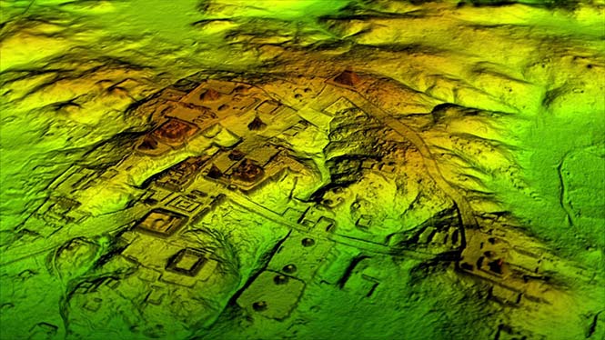
Lidar and UAV technology has revealed hundreds of previously unknown Mayan ruins in the Guatemalan rainforest.
The Optech Titan stripped away overlying vegetation to reveal extensive Mayan ruins in Guatemala’s rainforest. (Image: Teledyne Optech)
In what is considered biggest aerial lidar survey in the history of archaeology, a vast and complex civilization has been discovered.
The University of Houston’s National Center for Airborne Laser Mapping (NCALM) used Teledyne Optech’s Titan sensor to identify raised highways, and complex irrigation and terracing systems.
The jungle of Central America is one of the last great frontiers of archaeology, according to National Geographic, which covered the new finds in a recent documentary, Lost Treasures of The Maya Snake Kings.
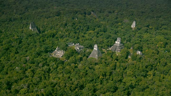
After the collapse of the Mayan civilization, its cities and monuments were quickly covered by thick rainforest, hiding it from airborne observation and making it very difficult to survey on foot. Over decades of work, the ancient civilization has gradually been revealed. But now technology is set to change everything.
Lidar digitally removes the forest canopy to reveal ancient ruins below, showing that Maya cities such as Tikal were much larger than ground-based research had suggested. (Photo: National Geographic)
Flying high above the rainforest, the Titan’s lasers penetrated the canopy to collect almost a million data points per second from the forest floor, giving archaeologists a “bare earth” view of the structures underneath.
Having covered 2,100 square kilometers, the Titan’s data revealed massive amounts of ruins hidden below the forest, showing that their urban centers were significantly larger than archaeologists had previously thought.
“Lidar is revolutionising archaeology the way the Hubble Space Telescope revolutionised astronomy,” Francisco Estrada-Belli, a Tulane University archaeologist, told National Geographic. “We’ll need 100 years to go through all [the data] and really understand what we’re seeing.”
(Image: Teledyne Optech)
“We are incredibly proud and excited that our award winning Titan multispectral lidar sensor has contributed to this spectacular discovery,” said Michel Stanier, EVP and general manager of Teledyne Optech. “The Titan’s ability to strip away overlying vegetation and map wide areas very quickly and accurately makes it an important tool for archaeologists, and we expect to see many more discoveries coming from it and our other airborne laser terrain mappers.”
The Optech Titan multi-spectral lidar sensor incorporates three independent laser wavelengths into a single sensor design, with beams at 532, 1064 and 1550 nanometers (0.5/1.0/1.5 microns) and a ground sampling rate of 300 kHz per beam.
Because Titan uses both green and infrared channels, it is capable of simultaneous water-depth mapping and high-precision 900-kHz topography.
Titan can also be used for purposes such as vegetative and forestry applications, which require multiple wavelengths for improved classification accuracy and carbon credit counting initiatives.
Lidar and UAV technology has revealed hundreds of previously unknown Mayan ruins in the Guatemalan rainforest.
The Optech Titan stripped away overlying vegetation to reveal extensive Mayan ruins in Guatemala’s rainforest. (Image: Teledyne Optech)
In what is considered biggest aerial lidar survey in the history of archaeology, a vast and complex civilization has been discovered.
The University of Houston’s National Center for Airborne Laser Mapping (NCALM) used Teledyne Optech’s Titan sensor to identify raised highways, and complex irrigation and terracing systems.
The jungle of Central America is one of the last great frontiers of archaeology, according to National Geographic, which covered the new finds in a recent documentary, Lost Treasures of The Maya Snake Kings.
After the collapse of the Mayan civilization, its cities and monuments were quickly covered by thick rainforest, hiding it from airborne observation and making it very difficult to survey on foot. Over decades of work, the ancient civilization has gradually been revealed. But now technology is set to change everything.
Lidar digitally removes the forest canopy to reveal ancient ruins below, showing that Maya cities such as Tikal were much larger than ground-based research had suggested. (Photo: National Geographic)
Flying high above the rainforest, the Titan’s lasers penetrated the canopy to collect almost a million data points per second from the forest floor, giving archaeologists a “bare earth” view of the structures underneath.
Having covered 2,100 square kilometers, the Titan’s data revealed massive amounts of ruins hidden below the forest, showing that their urban centers were significantly larger than archaeologists had previously thought.
“Lidar is revolutionising archaeology the way the Hubble Space Telescope revolutionised astronomy,” Francisco Estrada-Belli, a Tulane University archaeologist, told National Geographic. “We’ll need 100 years to go through all [the data] and really understand what we’re seeing.”
(Image: Teledyne Optech)
“We are incredibly proud and excited that our award winning Titan multispectral lidar sensor has contributed to this spectacular discovery,” said Michel Stanier, EVP and general manager of Teledyne Optech. “The Titan’s ability to strip away overlying vegetation and map wide areas very quickly and accurately makes it an important tool for archaeologists, and we expect to see many more discoveries coming from it and our other airborne laser terrain mappers.”
The Optech Titan multi-spectral lidar sensor incorporates three independent laser wavelengths into a single sensor design, with beams at 532, 1064 and 1550 nanometers (0.5/1.0/1.5 microns) and a ground sampling rate of 300 kHz per beam.
Image: Teledyne Optech
Because Titan uses both green and infrared channels, it is capable of simultaneous water-depth mapping and high-precision 900-kHz topography.
Titan can also be used for purposes such as vegetative and forestry applications, which require multiple wavelengths for improved classification accuracy and carbon credit counting initiatives.