San Francisco local officials are questioning the safety of autonomous vehicles (AV), also known as self-driving cars, due to frequent reports of traffic violations, delaying public transportation and emergency vehicles, causing traffic congestion as well as driving onto public sidewalks.
California officials granted the first AV deployment permits this year, allowing companies to release self-driving cars onto city streets and to provide passenger service as robotaxis. Since granting permits to AV companies such as Waymo and Cruise, self-driving vehicles have been creating a multitude of issues with public safety, including a recent incident of a Cruise AV stopping a bus on its route for over seven minutes.
As state governments have the legal power to grant permits to AV companies to conduct testing and ride hail services, city officials are left powerless to control self-driving car incidents that affect residents and public safety. City officials also struggle to obtain information regarding AV-induced road blockages and even a comprehensive list of all companies have deployed self-driving vehicles onto their roads.
Rohde & Schwarz has expanded the capabilities of its R&S SMBV100A/B GNSS simulator and R&S CMW500 LTE network simulator to operate with Vector CANoe .Car2x, a software tool for simulation, development and test of V2X-based communication applications.
Image: Rohde & Schwarz
The solution enables engineers to easily verify critical end-to-end safety-related V2X scenarios in a lab environment. It uses the C-V2X software package for the R&S CMW500 to simulate the physical- and MAC-layer, transmitting and receiving data over the simulated PC5 interface. This covers ideal, faded and congested channel conditions to the device under test (DUT). In its current form, the solution supports both GNSS and PSSS/SSSS sidelink synchronization options.
Rohde & Schwarz and Vector have successfully demonstrated its solution, which is designed to configure and run traffic scenarios to comprehensively test the physical layer 3GPP Rel. 14 up to the application layer of C-V2X ECUs in a lab environment.
Rohde & Schwarz is demonstrating the test solution at Mobile World Congress 2019 in Barcelona in hall 6, booth 6C40, Feb. 25-28.
The automotive industry is evolving toward connected and autonomous vehicles that offer many benefits, such as improved safety, less traffic congestion, reduced environmental impact, and lower capital expenditure. With the trend to equip vehicles with 3GPP Release 14 C-V2X ECUs, peer-to-peer data transfer in ad-hoc networks between vehicles will be realized. All vehicles share location, speed and trajectory, enabling warnings regarding on-road dangers to be shared between drivers.
Applications cover use cases such as vehicle-to-vehicle (V2V) communication, data exchange with roadway infrastructure (V2I), and interaction with vulnerable road users such as pedestrians (V2P). Data communication is implemented in the 5.8 GHz and 5.9 GHz intelligent transportation system (ITS) spectrum bands.
Traffic scenarios
CANoe .Car2x offers a range of functions designed to configure and run traffic scenarios. This allows the stimulation of a C-V2X control unit according to a defined traffic situation that tests the implemented application in a structured manner.
The included Car2x Scenario Editor supports the creation of traffic scenarios using a graphical interface. CANoe .Car2x generates the corresponding ITS communication based on the test scenario. The scenario is then played back with the R&S CMW500 providing the radio access layer with the specific physical interface. This verifies data transmission and reception over the PC5 interface so that the functions of the ECU can be tested comprehensively.
The combined solution covers all layers – the complete stack, 3GPP Radio Access Layers for C-V2X Mode 4, region specific ITS protocol layers such as EU ITS-G5 and U.S. WAVE and the ITS application message sets.
This enables testing of specific use cases such as Emergency Electronic Brake Light (EEBL), Left-Turn Assist (LTA) or Intersection Movement Assist (IMA), as well as more complex scenarios with multiple simulated vehicles such as a congested highway.
Additionally, security mechanisms could also be verified running simulations with both valid and invalid signed certificates. On top of this CANoe supports all common automotive bus connectivity such as CAN, LIN, MOST, FlexRay and Automotive Ethernet, enabling the test engineer to analyze or stimulate the ECU within an entire system from their desk.
By extending the solution with the VN4610 interface from Vector, customers can access IEEE 802.11p and CAN (FD) networks as well. This enables users to analyze and test C-V2X and IEEE 802.11p (DSRC) communication and related applications with a single setup and a common user interface.
“C-V2X device testing through the application layer is a significant step towards achieving the goal of having fully connected vehicles to improve road safety,” said Anton Messmer, vice president of Mobile Radio Testers at Rohde & Schwarz. “Our efforts in developing and verifying C-V2X end-to-end application scenarios are enabling user equipment manufacturers and OEMs to reduce the time needed to roll out C-V2X technology on a worldwide basis.”
“CANoe .Car2x has a strong focus on testing V2X based protocols and ADAS applications. This combined solution, CANoe .Car2x with the R&S CMW500, enables our customers to stimulate the V2X ECU with real scenario data in order to perform tests from physical layer up to the application,” said Stefan Krauß, director of Tools for Network and Distribution Systems at Vector. “The collaboration on this solution shows what can be achieved when leading players from the automotive and telecommunication industries work hand in hand.”
GIS software company Caliper has released new highway exit data for the United States and Canada.
Users of Maptitude 2018 with the Canada or United States country packages can download a free point layer containing all signed and numbered highway exits within their respective country.
The highway exits layer allows users to find the nearest highway interchange to a particular location or determine proximity to a desired interchange. Applications include site location assessment, commercial real estate, franchise development and accessibility studies.
The data can also be used in conjunction with the free U.S. traffic count data to determine traffic volumes around a chosen exit.
The Highway Exits and Interchanges layer can be added to any Maptitude 2018 map.
The Connected Citizens Program, a two-way sharing of publicly available traffic and road condition information, offers governments a stream of data, constantly updated in real-time, whenever they need it. This enables personnel to make data-driven infrastructure decisions and improves the efficiency of incident response.
Waze, a free crowdsourced traffic and navigation app, is now fully supported by ArcGIS Online, where its live feed of mapped traffic alerts and other information, such as accidents, congestion and street damage, can be used in applications in minutes.
“Municipalities can now leverage near up-to-the-minute reports without having to write code or purchase additional software,” said Andrew Stauffer, manager of civic technology at Esri. “Mapped Waze data is available immediately in all ArcGIS apps, where traffic engineers and even city planners can use it to maintain and build safer, more efficient transportation systems.”
Municipal personnel like traffic engineers can start using this data to analyze where the biggest problems exist on the roads so they can create targeted solutions. For instance, by seeing exactly where the most crashes are occurring, engineers can know where they need to place more officers, replace street signs, or adjust the timing of traffic lights.
“The Waze Connected Citizens Program is all about removing any barriers to innovation,” said Adam Fried, Waze Global Partnerships manager. “We want to help our partners leverage existing infrastructure and be able to make better data-driven decisions. Now, with just a couple of clicks, a city can easily access and analyze Waze data within Esri ArcGIS and use those insights to improve roadway management and build safer roads for its citizens.”
Much of the information government organizations rely on to make decisions is becoming obsolete as communities are starting to use technology like sensors and drones to monitor the quality of roads, bridges, and utilities. The Waze Connected Citizens Program gives municipalities the power to harness crowdsourced driver data to not only improve safety and congestion but also make better-informed decisions by giving planners an edge to start building infrastructure that meets the demands of a twenty-first-century city.
Governments can sign up for the free Waze Connected Citizens Program and start working with the alert data in ArcGIS to create operational dashboards that departments can use right away.
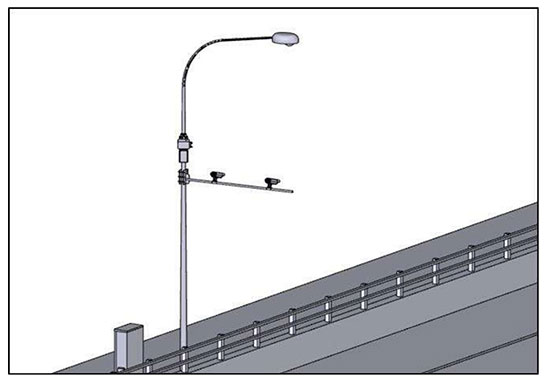
The Singapore Land Transport Authority (LTA) has begun testing an Automatic Number Plate Recognition (ANPR) camera system with Dedicated Short Range Communications (DSRC) beacons at various locations along expressways and major thoroughfares.
The testing started March 26 and will conclude in 2019.
An example of the equipment that will be mounted on existing roadside infrastructure. (Image: LTA)
The use of ANPR technology will facilitate enforcement, while DSRC beacons will also be installed in some areas to enhance positioning accuracy in Singapore’s highly urbanized environment.
The tests will enable LTA to determine the performance and reliability of such technologies under various real-life environmental and traffic conditions for future traffic management systems that will leverage GNSS technology.
The technologies being tested do not require heavy physical infrastructure and will be mounted on existing roadside infrastructure such as overhead bridges, overhead gantry signages and lamp posts, as well as EMAS gantries.
Testing equipment will also be mounted onto vehicles, which will be deployed at localized areas such as Tuas South from April 2018, before expanding island-wide for testing.
In 2016, LTA awarded a S$556 million contract to the consortium of NCS and Mitsubishi Heavy Industries Engine System Asia to build a next-generation electronic road pricing system based on GNSS technology, reports Channel NewsAsia.
The new system will allow motorists to be charged according to distance traveled on congested roads, removing the need for physical gantries.
An example of the equipment that will be mounted onto vehicles. (Image: LTA)
Esri has published a Hurricane Irma Resource Catalog in advance of the Category 4 hurricane cutting through the Caribbean islands on its path toward Florida.
The catalog features read-to-use applications compiled by the Esri Disaster Response Program (EDRP). EDRP is an around-the-clock service that helps with monitoring events online, discovering useful content, augmenting software and obtaining assistance from Esri experts.
To see the track of the hurricane, Esri provides its hurricane map.
Resources include:
Hurricane Public Information Map (PIM)
Hurricane Impact Summary
Hurricane Force Wind Impact Summary
Storm Surge and Flooding
Storm Surge Inundation
Hurricane Evacuation Zones
Waze Alerts – Hurricane Irma
Florida 511 – Real-Time Traffic Information
Hurricane Irma Photo Story Map
Airport and Port Status
NOAA Real-Time Coastal Observations
Florida Division of Emergency Management Open Data
Waze alerts light up Florida highways as people evacuate. (Image: Esri)
TomTom‘s Kenneth Clay highlights traffic features the company offers with its mapping services. TomTom exhibited at the 2017 Esri User Conference, which took place July 10-14 in San Diego, California.
uAvionix Corporation, an unmanned aircraft system (UAS) avionics provider, has developed and is testing a tiny ADS-B transceiver for UAVs.
Weighing less than 1 gram, a dime-sized ADS-B prototype module for drones with transmission power between 0.01-0.25 Watts could provide visibility to any aircraft equipped with ADS-B “IN” avionics from 1 to 10 miles away, and is small enough to integrate directly into professional and consumer-level drones.
uAvionix is working with the Federal Aviation Administration (FAA) and other partners under a Cooperative Research and Development Agreement (CRADA) to test the unit, along with other uAvionix products.
uAvionix Ping ADS-B transceiver. Photo: uAvionix
A recent study published in January 2017 by The MITRE Corporation’s Center for Advanced Aviation System Development (CAASD) imagined a future of high-traffic densities of drones operating with ADS-B onboard, and then sought to understand the implications of that.
The study suggests that there is a nominal transmission power output between 0.01 and 0.1 Watts that when coupled with limited drone traffic densities can result in a compatible operation with the system as a whole.
“We developed this product to show the world the art of the possible,” said Paul Beard, CEO of uAvionix. “We can’t yet sell this device because the standards that were developed for ADS-B did not take into account the value of air-to-air ADS-B communications between small drones or between small drones and manned aircraft. It’s literally not legal to transmit at these low power outputs. We aim to lead the discussion and development of those standards, and will work with any regulatory body to do so.”
TomTom has signed a global, multi-year agreement to provide maps and traffic data for the Uber driver app.
TomTom’s advanced map-making technology, combined with its traffic information, will ensure Uber has a seamless navigation experience, accurate arrival times and efficient journeys in more than 300 cities around the world, according to a TomTom news release.
“We are excited to provide Uber with our best-in-class location data,” said Charles Cautley, managing director, Maps and Licensing at TomTom. “TomTom is a truly independent map provider with the platform for the future. With this platform, TomTom is the trusted partner for innovative and future proof location technology for the global automotive and consumer technology industry.”
“We look forward to working with TomTom, a leader in the mapping and navigation space,” said Matt Wyndowe, head of Product Partnerships at Uber. “Their mapping and traffic data will help ensure we continue to provide a great experience for drivers everywhere.”
Telit’s cellular and GNSS Internet of Things (IoT) modules will integrate Yon Motor, a new product from Nastek Indústria e Tecnologia, bringing to market a tiny vehicle tracker with a user-friendly mobile app. Besides vehicle security, speed is a top concerns for parents of teenage drivers. Yon Motor targets this market, delivering real-time location and speed data to a smartphone app along with a number of vehicle security features.
The innovative project was developed in partnership with Telit. The company’s GL865-QUAD and SL871 GPS modules are integrated in the miniature Yon Motor to deliver machine-to-machine communication and location awareness respectively. The free Yon Motor mobile app is available for download in iOS and Android.
“What parent would not want to know about their children’s night out or would not sleep better knowing that they are respecting speed limits? The idea of Yon Motor was to create something that could get people closer through Internet of Things,” says Lauro Cruz, CTO, Nastek. The Yon Motor tracker was built with latest generation technology. Moreover, the solution is lightweight and waterproof, permitting parents to secure it to any motor vehicle.
“The Yon mobile app lets users follow vehicle movements in real time and can be downloaded for free to a smartphone. The tracker helps combat car accidents involving young people, since parents have full visibility of their children’s driving speeds and the routes they take,” Cruz said.
The PennDOT TDS developed by GeoDecisions enables collection and processing of millions of data points.
GeoDecisions, an information technology company specializing in geospatial solutions, has developed a new traffic data system (TDS) that processes more than 20 million new records per month for the Pennsylvania Department of Transportation (PennDOT).
Built on the Esri platform, the TDS helps PennDOT’s Bureau of Planning and Research better manage the download of traffic data from collection sites throughout the commonwealth of Pennsylvania.
“Built to Federal Highway Administration standards, GeoDecisions’ redesign of our TDS provides us a method to seamlessly introduce new counting devices, more efficiently verify our raw traffic data, and speed up our process for creating yearly traffic volume maps,” said Andrea Bahoric, planning division manager with PennDOT.
The new TDS improves PennDOT supervision of 45,000 short-term or portable counters that classify vehicles, record traffic volume and weight, and determine driving speed. The system’s mobile Field Operations Module (FOM) also streamlines in-pavement counter inventory and maintenance activities.
“FOM enables PennDOT field technicians to use smartphones or tablets to perform site reviews and document issues,” said Greg Ulp, senior project manager with GeoDecisions. “Convenience and efficiency are critical factors when enhancing technology and managing assets.”
PennDOT’s predecessor traffic data management system contained nine applications with dated technology requiring manual intervention to collect and verify information. GeoDecisions’ TDS redesign features five modules streamlined for better performance and usability. The new automated system includes remote user access and cutting-edge GIS mapping, web service, database and coding technologies.
“Our transportation system solutions provide a proven business model for analytics, reporting, reliability, and technology workflow management,” said Tom Saltzer, vice president of government delivery with GeoDecisions. “PennDOT’s redesigned TDS is a long-term collection, verification, and geospatial solution that reflects their ongoing enterprise GIS investment strategy.”
TomTom’s map and traffic information have been chosen by the University of Minnesota’s Accessibility Observatory as part of a new national accessibility data set.
TomTom will provide map and historical speed data to help analyze accessibility to jobs for driving and transit for metropolitan areas across the United States. For transit data, the Observatory is relying on open, public sources using a method developed at the University with support from the Center for Transportation Studies.
Study partners will be able to use this data for policy development, local transportation system evaluation, performance management, planning and research efforts. Each partner will have direct digital access to the accessibility datasets for the jurisdictions of all partners and will receive detailed reports of local accessibility trends and patterns. The Minnesota Department of Transportation is the lead agency and coordinator for the national pooled-fund study. Other participating agencies are the Federal Highway Administration (FHWA) and the DOTs of California, Florida, Iowa, North Carolina, Virginia and Wisconsin.
“Today’s transportation user wants more than mobility — they want accessibility and they want MnDOT to invest in the appropriate solution, at the right place, at the right time, and at the appropriate cost,” said Tim Henkel, division director of modal planning and program management at MnDOT. “The Accessibility Observatory offers solutions to these decision-making challenges.”
The Transportation Pooled Fund Program, part of the National Cooperative Highway Research Program, allows state DOTs, FHWA program offices, and other organizations to combine resources and achieve common research goals. Additional partners are welcome to join the study.
“We’re excited that the UMN Accessibility Observatory has selected TomTom to help provide geospatial and transportation information for this project,” said Ralf-Peter Schäfer, head of traffic at TomTom. “We are confident that the TomTom map and traffic content will contribute to a better understanding of job accessibility nationwide.”