Tag: Tunisia

  • The world is on fire: ESA maps global wildfires

    The world is on fire: ESA maps global wildfires

    Image: ESA
    Image: ESA

    Wildfires have recently spread across Greece, Italy, Spain, Portugal, Algeria, Tunisia and Canada, causing mass environmental and economic damage as well as human casualties. Scientists have warned that wildfires are becoming more frequent and more widespread.

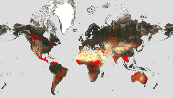
    In response, an upgraded version of the World Fire Atlas from the European Space Agency (ESA) is now available. The atlas provides a detailed analysis and map of wildfires across the globe.

    Rising global temperatures and the increased extreme weather has led to a surge in the number of wildfires rapidly consuming extensive areas of vegetation and forested lands.

    Considering the severe wildfires, ESA has reopened its World Fire Atlas which offers an insight into the distribution of individual fires taking place at a global scale.

    Through its interactive dashboard, users can compare the frequency of fires between countries as well as analyze the evolution of each wildfire taking place over time. The atlas was first available in 2019 and it supported both European civil protection agencies and firefighters.

    The dashboard uses night-time data from the sea and land surface temperature radiometer (SLSTR) on board the Copernicus Sentinel-3A satellite. Working like a thermometer in the sky, the sensor measures thermal infrared radiation to take the temperature of Earth’s land surfaces which is used to detect the fires.

    Data from the Copernicus Sentinel-3B satellite will be added to the atlas in December.

    Over the previous seven years, data from the World Fire Atlas show a substantial number of fires detected in Portugal, Italy, Greece, France and Spain.

    Data also shows that Canada has experienced 11,598 fires during the first seven months of this year alone. This is a 705% increase compared to fires detected over the same period of the previous six years. Canada is currently battling the country’s worst wildfire season on record, with more than 10 million ha of land burned, which is said to increase in the coming weeks.

  • ComNav helps bring GNSS benefits to Africa

    ComNav helps bring GNSS benefits to Africa

    ComNav Technology Ltd. is providing GNSS technology to Africa for projects in land mapping, continuously operating reference station (CORS) construction, precision agriculture and other fields, according to a Feb. 11 article in People’s Daily, the largest newspaper in China.

    Every day, thousands of users in Africa are using GNSS products, the newspaper stated, highlighting specifically the use of China’s BeiDou satellite navigation system. For instance, CORS using ComNav GNSS/BeiDou receivers have been built in 11 sub-Saharan African countries, including Kenya and Uganda.

    Uganda. To meet the demand for high-precision GNSS, the government of Uganda purchased ComNav’s real-time kinematic (RTK) receivers to build its own CORS. Thirty stations have been built so far, creating the most advanced CORS network in East Africa. Its high-precision spatial and temporal information supports land mapping, mining, vehicle management and meteorological monitoring, among other industries.

    In 2015, Mulindwa David, chairman of the Uganda Surveying Association, and others visited the Shanghai headquarters of ComNav to learn about its high-precision products and technologies. After training, David and others mastered basic RTK operation and learned simple maintenance.

    David used to carry heavy optical equipment every day, but now he only needs to hold a BeiDou receiver to process the relevant data, which has greatly improved his work efficiency and accuracy. “It took at least three days to survey a dozen kilometers of road with optical equipment,” he said. “With BeiDou high-precision receivers, only 10 hours is enough.”

    The Uganda CORS network. (Image: ComNav)
    The Uganda CORS network. (Image: ComNav)

    Burkina Faso. In response to the COVID-19 outbreak, the Burkina Faso government decided to build a hospital for infectious diseases. In April 2021, it used ComNav GNSS high-precision technology to provide survey data for the hospital’s construction. The land security and topographic surveying tasks were completed in six days, half the time scheduled, said Augustin Bamouni, secretary-general of the country’s national surveying association.

    A surveyor in Burkina-Faso surveys the site of a new hospital for infectious diseases. (Photo: ComNav)
    A surveyor in Burkina-Faso surveys the site of a new hospital for infectious diseases. (Photo: ComNav)

    Tunisia. The China-Arab BeiDou/GNSS Center is located in the Ghazara Science Park in northern Tunis, the capital of Tunisia. Inaugurated in 2018, it is China’s first overseas BeiDou center, providing satellite navigation training, test evaluation and technical research for African and Arab countries. On average, the center receives real-time data from more than 12 BeiDou satellites at once.

    The center will help Tunisia and other African countries train professionals in GNSS technology to support development of the digital economy, according to Amiri Khalil, state secretary in charge of scientific research at Tunisia’s Ministry of Higher Education.

    China-Arab Beidou/GNSS Center is in Tunis, Tunisia. (Photo: ComNav)
    China-Arab BeiDou/GNSS Center is in Tunis, Tunisia. (Photo: ComNav)

    China-Africa Forum. The first China-Africa BeiDou System Cooperation Forum was held in November 2021 in Beijing to encourage cooperation between China and Africa and promote use of BeiDou. Four cases from ComNav Technology were described in the forum’s document citing application scenarios of BeiDou in Africa.

    ComNav Technology has deepened its cooperation with Africa since China’s Belt and Road Initiative began in 2013. Besides providing products and technologies, ComNav arranged employees to go abroad to provide technical support, traveling to Cameroon, Nigeria, Mali, Zambia, and other African countries. Despite the pandemic, ComNav continues to provide professional service and training both in person and remotely.

  • Smart tractor with BeiDou successfully tested in Tunisia

    Smart tractor with BeiDou successfully tested in Tunisia

    Self-driving tractors using BeiDou are helping farmers plant vegetables, such as at Tawan Village of Wuzhong City in China’s Ningxia Hui Autonomous Region. The smart tractor uses the BeiDou navigation system to help local farmers improve efficiency and modernize agricultural work. (Photo: Wang Peng, Xinhua News Agency)
    Photo: Wang Peng, Xinhua News Agency

    A self-driving tractor using the BeiDou Navigation Satellite System (BDS) was tested successfully March 10 in northwestern Tunisia, according to China.org.cn.

    The representatives of China-Arab BDS/GNSS center and the Arab Information and Communication Technologies Organization (AICTO), as well as the academic staff of an engineering school in Mjez El-Beb region in northwestern Tunisia, attended the test ceremony.

    The smart tractor, used in various agricultural activities, was equipped with a BDS receiver so that it could be controlled remotely without a driver.

    “I am very impressed and surprised by the quality of the equipment offered by BeiDou,” said Sami Trimech, the strategic planning and development director at AICTO.

    “We had a dream to bring BeiDou to the Arab countries,” said Nour Laabidi, the project manager at AICTO and head of China-Arab BDS/GNSS center in Tunisia.

    “This is a pilot project. We are happy to implement it in our country and I hope that all Arab countries will be able to use this Chinese technology,” Laabidi said.

    Hassan Kherroubi, a specialist in the mechanical industry at the Mjez El-Beb engineering school, stressed the contribution of this Chinese technology to the agricultural sector in Tunisia.

    Agricultural activities, including harvest, will be more profitable and more effective with such technologies, according to Kherroubi.

    “Our main concern is to benefit all Arab and African countries of this fruitful cooperation between Tunisia and China,” Kherroubi said, adding that this advanced technology will bring a bright future to the region.

    BDS is compatible with other navigation systems, such as GPS, and users can receive services from both systems at the same time, improving positioning accuracy.

  • BeiDou inaugurates first overseas center in Tunisia

    BeiDou inaugurates first overseas center in Tunisia

    The first overseas center for China’s BeiDou Navigation Satellite System (BDS) was inaugurated in Tunis, Tunisia, on April 10, according to the Xinhua News Agency.

    The China-Arab States BDS/GNSS Center was established as a pilot project between China and the Tunisia-based Arab Information and Communication Technology Organization (AICTO), an Arab governmental organization under the Arab League, to promote the global application of BeiDou, said Ran Chengqi, director of the China Satellite Navigation Office.

    “The center could serve as both a window to showcase the BDS, and a platform for promoting international exchanges and cooperation,” Ran said.

    Mohamed Ben Amor, secretary general of AICTO, hailed the center as a unique technology project for the Arab region and the entire world. AICTO will “intensify its cooperation with China in the field of satellite navigation to boost technological advance and economic development in the region,” Amor said.

    The BeiDou pilot project will help train satellite navigation scientists and develop digital economy in Arab countries, according to Khalil Amiri, Tunisia’s secretary of state for scientific research. “We are working closely with China to effectively access and develop win-win database services via BeiDou and other satellites for various uses,” Amiri said.

    Ran (left front) and Amor shake hands during the inauguration ceremony of the China-Arab States BDS/GNSS Center in Tunis. (Photo: Xinhua)