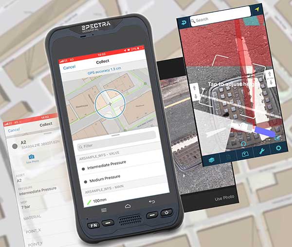
MGISS, a U.K. geospatial specialist, has released a new version of its web app TopoGrafi that allows for the display of 3D data in real-world models. With enhanced 3D data processing capabilities, TopoGrafi is an end-to-end platform for capturing buried asset data and processing it for augmented reality visualizations.
Aimed at the utility and infrastructure sectors, TopoGrafi is helping organizations in water and highway sectors enhance asset location data, improve on-site safety and reduce construction and maintenance costs.
Designed to be used alongside apps such as Esri Collector for ArcGIS, the TopoGrafi platform uses GNSS data.
It applies near-real-time conversions, transforming the recorded positions to local reference systems and aligning it with high-accuracy mapping including Ordnance Survey MasterMap.
The TopoGrafi toolkit also includes functionality to “snap” 3D features to each other and to other spatially referenced data, in order to create a true 3D model that can then be used to create Augmented Reality visualizations accessible from the desktop or in the field.
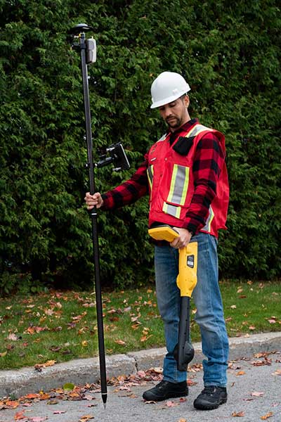
Eos Locate for Collector combines three core technologies: Eos Arrow GNSS receivers, Esri Collector, and the Vivax-Metrotech vLoc Series of locator devices.
With Eos Locate for Collector, one field worker can collect both GNSS locations and locator data (such as depth below cover) for any buried asset including water, sewer, electric, cable, gas, fiber infrastructure and more. They can do so quickly, accurately and without the need for any additional field or office support.
“We are giving our Arrow GNSS customers a solution today that allows them to combine both locator data and high-accuracy locations in web maps,” Eos CTO Jean-Yves Lauture said. “This greatly simplifies their workflow by allowing one person to do underground locates and GIS mapping simultaneously.”
“This is a big step forward for utility organizations who need to gain better visibility of their infrastructure,” said Doug Morgenthaler, Esri program manager. “With today’s technology, utilities can already see where new assets are being put in the ground. The challenge historically has been figuring out where existing assets are.”
Eos Locate for Collector not only streamlines underground-asset mapping, but also improves office production times. It eliminates the need to manually combine datasets from the locator and GPS devices within ArcGIS.
“Seeing all that information from utility locators and GPS receivers packaged directly into a GIS application is exceptional,” Vivax-Metrotech Eastern Regional Sales Manager Kelvin Cherrington said. “This solution will help utilities create maps of their underground assets with a much more modern and efficient methodology.”
Indiana American Water Early Adoption
Earlier this year, Indiana American Water approached Eos to seek a solution that consolidated their utility-locate workflow with their Arrow and Collector field work.
“We had the manpower to put paint down,” said Todd Chapman, Indiana American Water Senior GIS Analyst. “But we would need to hire another person to map the locations with our Arrow Gold GNSS receivers.”
Chapman estimates Eos Locate for Collector will cut their field time in half as well as enable the creation of extremely accurate buried-infrastructure maps in ArcGIS.
“Previously, we were seeing that our old water mains could be off by up to 20 feet,” Chapman said. “With the new Eos Locate for Collector, we’re seeing that it’s accurate to under an inch.”
The initial release of Eos Locate for Collector runs on Apple’s iOS iPhones and iPads and supports the vLoc Series from Vivax Metrotech. Future releases of Eos Locate for Collector will support additional locator models including the vScan series.
With accurate digital twins of their buried infrastructure, utilities across sectors can expect improvements to safety, damage prevention, field efficiency and regulatory compliance.
“Not only does this mean quicker responses to 811 tickets and fewer liabilities during field digs,” Lauture said. “But it also constitutes a major step forward toward the highly efficient future of 3D asset management and viable augmented-reality workflows.”
Avineon Inc. has launched a new portion of the Avineon Innovation Lab dedicated to articles, white papers and videos highlighting the impact of Esri’s Network Management System in the ArcGIS Platform. Avineon is a provider of geospatial, information technology and engineering support services.
The new section focuses on Avineon’s contributions, expertise and partnership with Esri on the next evolution of GIS Network Management: the Utility Network.
Part of the ArcGIS platform, the Utility Network is available on any device.
GIS services and solutions have been a part of Avineon’s success for the last 25 years, which is keeping pace with evolving technology and the impact GIS has on companies in the utility and telecommunications industries.
The Utility Network lets users create, manage, and share electric, water, wastewater, gas, district heating, and telecommunications asset data. The beta release of the Utility Network comes with base data models for electric, gas and water networks.
The technology is capable of supporting other networks — such as district heating, telecommunication and wastewater — but, for now, users need to build their own data models or rely on partners. Esri will provide base data models in some of these areas in later releases.
“Avineon has been a valuable partner and contributor to Esri’s Utility Network throughout the early adopter program, providing valuable feedback to our product teams,” commented Bill Meehan, Director of Utility Solutions for Esri. “The resulting Network Management System in the ArcGIS Platform will support utility and telecommunication companies as they execute their business plans for innovation, digital transition and transformation, sustainability, and smart ecosystems (smart grid, smart buildings, smart transportation, smart cities, etc.). We believe Avineon’s partnership with Esri and offerings like Avineon’s Head Start program, as well as observations into the practical applications of the Utility Network, through their Innovation Lab, will help industries understand the strategic and tactical pathway to maximize the value of their GIS now and into the future.”
Joel Campbell, Avineon’s vice president of Commercial Systems, added, “As an Esri business partner, it is exciting to support our customers and contribute to Esri’s vision of the ArcGIS Platform. These new capabilities serve as the foundation for delivering a new generation of business applications leveraging web and services patterns as well as evolved network management capabilities. We at Avineon look forward to utilizing our Innovation Lab as an outlet to share the lessons learned, best practices, and case studies around the newest evolution of GIS and its impact on the utility and telecommunication industries.”
Organizations work together to fight cyber attacks with innovations to visualize threats.
Esri and the U.S. Department of Energy’s Idaho National Laboratory (INL) have entered into a cooperative research and development agreement (CRADA) to collaboratively research and create prototype concepts with a specific focus on location intelligence solutions for the protection of critical infrastructure and critical missions.
The work will also estimate the impacts on critical infrastructure caused by exploited cyber vulnerabilities and targeted attacks.
Esri provides geospatial analysis and visualization capabilities across infrastructure industries like water, electric, oil and transportation, as well as in support of federal, state and local governments charged with the mission of protecting those industries.
These capabilities, combined with INL’s knowledge and capabilities for securing these systems from physical and cybersecurity threats, make this cooperative research and development effort truly unique in addressing crucial gaps in cyber/physical analysis and situational awareness technologies.
INL is the nation’s leading center for nuclear energy research and development, working in energy, national security, science, and the environment. Esri and INL have worked together for more than three years.
“We are looking forward to working closely with INL in this capacity,” said Brian Biesecker, technical director, Esri intelligence community. “As the government continues to embrace new technologies, CRADAs provide a great way for private and public partnerships to continue moving our country forward.”
EagleView, provider of aerial imagery and data analytics for government and commercial industries, has acquired OmniEarth, developer of machine learning technologies and decision-making tools for the water resource management, energy and insurance markets.
With the acquisition, EagleView gains OmniEarth’s machine learning capabilities, resulting in higher accuracy and precision of existing automated datasets.
OmniEarth’s ability to extract data from geospatial imagery will enhance EagleView’s property reports and Pictometry imagery classification of land areas such as impervious surfaces or irrigated farmland. It will also better identify roof shape and condition, tree overhang, decks, pools and other notable property features, EagleView said.
“We’re excited to welcome OmniEarth’s strong research-oriented management team, who will add to the innovative work that we’re doing at EagleView,” said EagleView President Rishi Daga. “This acquisition aligns perfectly with our mission of transforming industries by providing answers and saving time and money.”
Water authorities and government agencies rely on the water resource management tools from OmniEarth to determine budgeting and water cost savings for individual parcels as well as identify the overuse or abuse of water. Like EagleView, OmniEarth also supports the insurance underwriting market through its property feature identification capabilities.
“By gaining access to EagleView’s world-class Pictometry image library and product infrastructure, the OmniEarth team will be able to accelerate its development of advanced analytic solutions,” said Lars Dyrud, President and CEO of OmniEarth. “EagleView and OmniEarth have a shared goal of problem-solving and will be able to work together to achieve that vision.”
The acquisition gives EagleView opportunities to offer additional property data solutions for roof rating, virtual inspection, vegetation mapping, impervious surface mapping, solar suitability, and insurance prefill.
“OnmiEarth’s machine learning capabilities will create new opportunities for EagleView to use our imagery and property measurements to create a large prefill database,” said Frank Giuffrida, EagleView’s Executive Vice President of Engineering. “Additionally, marrying our high-resolution imagery and existing technologies with this machine learning system will help us accelerate our product development in existing markets as well as enter into new markets.”
EagleView is enthusiastic that the OmniEarth technologies will accelerate time-to-market on new product enhancements and greatly improve customer workflow capabilities. These innovations align with EagleView’s goals of capturing more frequent, higher-resolution imagery that covers more physical area and scaling through automation.
The membership of the Open Geospatial Consortium (OGC) seeks public comment on its WaterML 2 – Part 3, Surface Hydrology Features Conceptual Model.
The OGC WaterML 2 – Part 3, Surface Hydrology Features Conceptual Model (HY_Features) is part of an intended ‘OGC WaterML 2’ suite of standards that groups water-related OGC standards. The candidate standard follows Part 1: Timeseries, and Part 2: Ratings, Gaugings and Sections.
The candidate HY_Features standard defines a common feature model for the identification and description of surface hydrologic features. The feature model is based on established models and patterns in use in the Hydrology domain and endorsed by WMO and UNESCO, such as those documented in the “International Glossary of Hydrology.”
The candidate HY_Features standard also defines a common conceptual information model for surface hydrologic features independent of their geometric representation and scale. The model describes fundamental relationship types that exist among major components of the hydrosphere. This includes relationships such as hierarchies of catchments, segmentation of watercourses, and topological connectivity of hydrologic features based on the flow and conservation of water.
The standard is intended to be used to document and share information about real-world objects that are studied in a wide range of hydrologic study types. The original design goal for HY_Features was to link hydrologic information across the scientific and technical programs of organizations with local to global scope, and to assist in discovery, access, and use of hydrologic data from different sources.
The HY_Features model is designed to support many types of hydrologic information and sub-disciplines. The model supports referencing information about a hydrologic feature across disparate information systems or products, thereby improving data integration within and among organizations.
Similarly, the model can be applied to cataloging of observations, model results, or other study information involving hydrologic features. The ability to represent the same catchment, river, or other hydrologic feature in several ways is critical for aggregation of cross-referenced or related features into integrated datasets and data products on global, regional, or basin scales.
Agreement on common concepts and methods is necessary to enable semantic interoperability of hydrologic data and services. The HY_Features model was developed in order to formalize concepts and relationships of hydrologic and hydrographic features using the WMO/UNESCO “International Glossary of Hydrology” as a starting point.
LandWorks Inc., a developer of innovative land management solutions, has improved its Web AutoMapper online service that translates land legal descriptions into GIS-ready map polygons.
The updated Web AutoMapper features a new interface that is easier to use, including a job detail webpage that lets users review and edit polygons before purchase. Clients can now have their property polygons mapped against USLandGrid’s national land base, with the option of buying land grid townships containing the mapped property.
“These changes make the Web AutoMapper even easier and more cost effective to use,” said LandWorks President Jerry Bramwell. “Anyone with a need to create land maps can do so in just a few minutes at minimal cost.”
For about 20 percent of the cost of manual mapping, Web AutoMapper has simplified land records mapping in the oil and gas, renewable energy, mining, banking, utility, pipeline, state/local government, telecommunications, transportation, water and real estate sectors. The cost to map a legal parcel description with Web AutoMapper is $2 per polygon with the USLandGrid offered at $7 per PLSS Township.
“The USLandGrid data provides the tie between a legal description and the geography of that parcel of land,” said USLandGrid Vice President of Sales Anthony Ford. “Producing polygons this way allows you to get your land positions on a map for critical analysis using the GIS.”
“LandWorks selected USLandGrid for inclusion in Web AutoMapper because it is the best basemap available for any industry or profession to use in mapping property legal descriptions,” said Bramwell. “An important benefit of the USLandGrid is that its data layers are continuously updated as more accurate survey data becomes available.”
LandWorks first introduced Web AutoMapper in 2013 as an inexpensive, fast and easy method of processing many types of standard property descriptions and converting them into digital map polygons. Legal descriptions that would take days or weeks to map manually can be processed in minutes with this online software-as-a-service application.
A customer simply logs onto Web AutoMapper and creates an account. The user then submits an Excel spreadsheet containing one or hundreds of legal descriptions in Jeffersonian Township/Range or Texas Survey/Abstract formats. Within seconds, Web AutoMapper provides an onscreen report detailing which polygons can be generated, which cannot, and shows an overview of the mapped polygons aligned to the USLandGrid.
If the customer decides to proceed, a credit card is provided. For customers who don’t already own the Grid, they have the option of buying it by the township along with their mapped polygons.
Web AutoMapper generates a zip file of the purchased polygons and USLandGrid townships either in Esri shapefile or file geodatabase format in NAD 83 or 27 for direct download into Esri ArcGIS software as well as other popular mapping systems, such as IHS Petra, IHS Kingdom and LMKR GeoGraphix.
As a cloud-based application, Web AutoMapper brings the full power of the standalone LandWorks AutoMapper software to every level of digital map user via the Internet. Introduced in 2002, the onsite AutoMapper package is purchased by an organization and sits behind their firewall as a production-grade GIS mapping tool. The software is used extensively by organizations that own or lease many land rights and must keep their property records up to date, such as local governments, energy companies and natural resource management entities.
Trimble has acquired privately held Telog Instruments Inc., based in Victor, New York. Telog is a wireless water infrastructure monitoring and management company. The acquisition extends Trimble’s smart water strategy by adding advanced water management technology and productivity solutions to the company’s portfolio. Financial terms were not disclosed.
Telog, founded in 1984, manufactures a suite of wireless remote monitoring, analytics and data acquisition systems that are used by thousands of water, wastewater and stormwater management utilities and private contractors throughout North America. Its Telogers family of battery-powered, environmentally rugged wireless monitors provide an automated means of collecting, archiving, presenting and sharing data from a wide variety of remote assets such as flowmeters, rain gauges, surcharge sensors, pre-treatment water quality sensors, lift stations and pressure sensors.
Applications for Telog solutions include remote monitoring of flow rates, reservoir and tank levels, water quality, well and groundwater levels, pump station performance, hydrant and valve pressure and sewer overflows. The solutions can also be combined with automated metering infrastructure to provide smart water networks that improve sustainability and water conservation and reduce leakage and non-revenue water. Customers can benefit through improved drinking water quality, lower water loss and leakage, reduced wastewater and stormwater overflows and spills, and enhanced regulatory compliance.
“Trimble remains focused on offering industry leading technology solutions for the water industry,” said Marcus McCarthy, general manager for Trimble’s Water Division. “The acquisition of Telog enables us to expand our portfolio of hardware and software products with industry leading real-time wireless sensors and monitoring solutions. The management of data in real time will provide value to customers facing a growing number of water supply, environmental and regulatory challenges.”
“We are very excited to join Trimble,” said Barry Ceci, founder, president and CEO of Telog. “In addition to the continued focus on supporting our current customers and our core North American market, the acquisition will enable us to grow Telog’s suite of products and expand our global footprint. This is an exciting time for Telog and our customers, who can also benefit from Trimble’s comprehensive portfolio of smart water management solutions.”
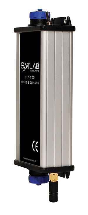
Swedish-based Survey and GIS equipment maker Satlab Geosolutions AB has announced the availability of its SLD-100 GNSS Rover accessory to facilitate Hydrographic measurement in bodies of water up to 100 meters in depth. It is designed for those who find themselves needing to survey into bodies of water, streams and rivers.
With survey-grade accuracy, the Satlab SLD-100 can be added to any brand GNSS RTK Rover to allow for position and depth measurements to be made simultaneously. With a built-in 10-hour lithium battery and transmitter unit with Bluetooth connectivity, the SLD-100 provides standard depth data streams in several industry standard NMEA formats at 1Hz, 4800 bps, providing compatibility with any hydrographic surveying software package.
“Our new SLD-100 survey receiver is extremely easy to use with position and depth information externally logged on a computer or controller,” said Birol Güçlüer”, CTO and partner of Satlab. “With the included transom mounting hardware, installation is quick and easy.”
The SLD-100 is available now for a suggested retail price of US$2995.
Watch animations of the recurring slope lineae (water stains) across four different craters and explore satellite imagery and elevation data for the Red Planet.
Below is an animation from the Jet Propulsion Laboratory showing seasonal flows in Hale Crater.
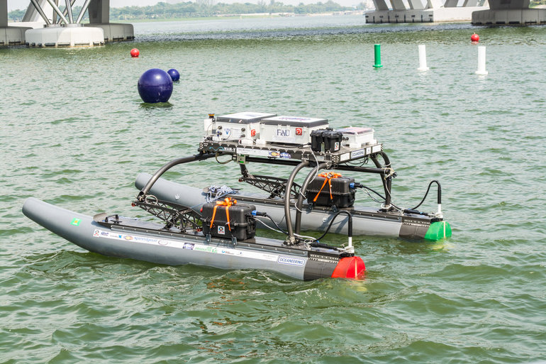
A research team at Florida Atlantic University’s (FAU) College of Engineering and Computer Science has received a $187,000 grant from the Florida Department of Transportation (FDOT) to develop autonomous waterborne vehicles that can assist in bridge inspections.
Although the technology is still in the early stages of development, the long-term aim is that the unmanned surface vehicles (USVs) could be used by the agency to make bridge inspectors’ work safer and more efficient, according to GovTech.com. FDOT currently uses a variety of methods and equipment to inspect and test the sections of the state’s 11,451 bridges that are above water level. However, the only method that can be used to check the sub-surface areas is divers, who search for cracks, erosion, damage and defects that might impact on a bridge’s safety. A high percentage of Florida’s bridges are in corrosive salt water, and divers frequently experience problems with low visibility from silt, sediment, debris and algae, weed or other plant matter.
The team from FAU’s Department of Ocean and Mechanical Engineering have experience in USV research, and won second place at the eighth annual International RoboBoat Competition in Virginia Beach, Va., according to GovTech.com.
Two months into a 12-month project, the team has upgraded a watercraft used for past research projects with a new propulsion system that allows the craft to maintain its position and heading during a bridge scan. The next phase of research will be to equip the craft with an acoustic scanning system that functions in a similar manner to a LiDAR (Light Detection and Ranging) system. By installing the scanner on a mount that can tilt and pan, researchers expect to obtain 3D models of the parts of the bridge that are below the water.
The current vessel is equipped with an automatic control system that uses GPS and a compass to direct the craft toward programmed waypoints, and can keep it steady in a variable current, allowing scanning to take place. Once the acoustic scanner is equipped in September, the team will begin testing the craft’s scanning capabilities on three bridges that have been recommended by FDOT for their diverse representation of the state’s bridge environments.
“These sorts of technologies aren’t really meant to replace wholesale divers and so forth,” the FAU project’s principal investigator, Karl von Ellenrieder, told GovTech.com. “It’s to make their jobs easier, and it’s another tool that can help them do their jobs better. The way I view it is, you would take a vehicle like this and it would allow you to more rapidly scan bridges, and then when you detect a problem, send out a diver to verify the problem through testing. If you’re going to send divers out into strong currents with nasty snakes and stuff, it’s better to have a good sense there’s a problem before you do that.”