Tag: Wireless LBS Insider

  • 5G, cellular’s next step, brings new positioning capabilities

    This comment piqued my ears when heard over the coffee-break table at ION’s International Technical Meeting last month: “There is a great deal of mutual ignorance between the 5G and PNT communities. I think that the 5G people are pretty naive about PNT and the PNT community is missing an opportunity.”

    So when news releases leading up to next week’s Mobile World Congress — several of them mentioning 5G in rosy terms, “catalyst for a better future” typical among these — started flooding my inbox this morning, it seemed an opportune time to investigate. Pardon my top-slice view; I’m not well-versed enough in the technology to discourse knowledgeably, but here’s quick round-up of salient points related to positioning in the fast-oncoming Next Step in cellular communications.


    Regular contributing editor for Professional OEM and UAV Tony Murfin will return to this space next month, with a column previewing the massive AUVSI Xponential show in Denver, April 30–May 3.  He’ll be there, too, covering the event!


    The cellular 5G standard has been designed to target latencies under one millisecond, data rates of up to ten gigabits per second, extremely high network reliability, and better accuracy in positioning. With location awareness becoming an essential feature of many new markets, positioning is consequently considered as an integral part of the system design of upcoming 5G mobile networks.

    Its feet firmly planted in both the present and the future, the cellular industry is currently in the midst of implementation of Long Term Evolution (LTE)-Advanced, an evolution of what might be called plain old LTE, and a “true 4G” mobile broadband. Simultaneously, the industry is preparing the next step, as “there is a vastly increased need for a new mobile communications system with even further enhanced capabilities, namely a fifth generation (5G) system.” 5G will process communication 10 times faster than 4G, according to experts. That’s enough to download a 3D movie in 30 seconds. It would take six minutes on 4G.

    Pyeongchang

    Alert techie viewers of the present ongoing Olympics in South Korea may have noted 5G in action there, in demos of such things as live-streaming virtual reality of bobsled and luge runs, putting the viewer in the breathtaking driver’s seat, and a test drive earlier this month from Seoul to Pyeongchang, a journey of several hours, without any human intervention whatsoever at the car’s controls. The demonstrations in Pyeongchang are laying down a backbone for what will be on show at the Tokyo Games in 2020, when 5G roll-out will be complete in many major metro areas.

    As trumpets sound the fanfare for next week’s Mobile World Congress in Barcelona, AT&T announced it will first roll out 5G to three locations: Dallas, Texas; Waco, Texas; and Atlanta, Georgia. The plans introduce the service to about a dozen U.S. markets by late this year. Qualcomm meanwhile is offering insight into its 5G chips.

    What has all this got to do with GNSS? Well, aside from the aforementioned precise positioning via cellular to be afforded by 5G, the two technologies share one prominent technique: adaptive array antennas for digital beam-forming. Here I am indebted to Gary McGraw of Rockwell Collins for a primer on the subject, which he presented at the International Technical Symposium on Navigation and Timing (ITSNT) in November 2016.

    Adaptive array technologies have many advantages for PNT: primarily, in mitigation for multipath and for jamming and spoofing mitigation. Adaptive antenna arrays  with digital beam-forming (DBF) are becoming increasingly important for PNT in challenging signal environments. DBF combines multiple antenna inputs to generate gain in arrival direction of the desired satellite signal and to create spatial nulls in direction of jamming.

    Langley Strikes Again — Early

    For some of the technical underpinnings to this technique, see the January 2017 Innovation column “Correlator beamforming for low-cost multipath mitigation” and the esteemed Prof. Langley’s February follow-up, “Mitigating interference with a dual-polarized antenna array in a real environment.”

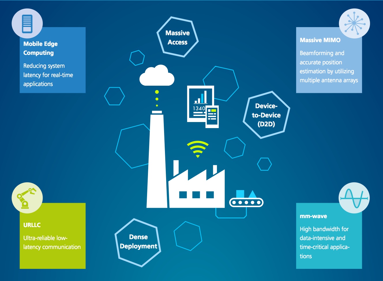
    Emerging applications of DBF in 5G  involve dense networks of picocells, small cellular base stations typically covering a small indoor area. Picocells extend coverage where outdoor signals do not reach well, and add network capacity in areas with very dense phone usage. In this context, 5G cellular architectures will use adaptive array technology to achieve high data rates, spectrum reuse and communications robustness.

    The implications for PNT are that 5G system architectures will require improved (relative) PNT to operate effectively, and these 5G picocells will be a source of PNT information in constrained environments.

    5G involves massive directional communications via multiple-input multiple-output (MIMO), enabling high-bandwidth communications in fading (multipath) channels by using multiple antenna inputs to adapt to channel. It can do this without knowledge of user location, but it adds to the processing complexity. The directional capability can enable multiple users to be serviced in a picocell at different frequencies, while permitting spectrum re-use by nearby picocells through narrow beam-width and the limited range of millimeter-wave frequencies.

    The PNT implications of 5G architectures, according to Gary McGraw of Rockwell, are, principally, that efficient operation of directional links will require some level of knowledge of user location with regard to picocells. Picocells will need to have the ability to do direction-of-arrival positioning and ranging in order to maintain connectivity with user nodes. This can be exploited by the user node for positioning and location-based services, particularly for indoor and dense urban environments. Meanwhile, the proliferation of adaptive array technology will drive down costs for other applications. Further, millimeter-wave transmit/receive modules will become commodity items, analogous to what cell phones have done for GPS chips.

    McGraw’s Summary

    5G picocells will be synergistic with PNT in challenged environments — naturally, indoor and dense urban. They will necessitate development of distributed, networked PNT processing and infrastructure. Availability of adaptive array technology will increase with deployment of 5G, and costs can be expected to drop dramatically. In addition to GNSS, adaptive array technologies can be employed to support short-range, relative PNT applications such as vehicle-to-vehicle communications and relative positioning.

    Driving the Bus

    The key driver for all this is that customers, the global We, expect the same quality of experience from Internet applications anytime, anywhere, and through any means of connectivity. The rapid proliferation of smartphones and other mobile devices that support a wide range of applications and services mean that image transfer and video-streaming, as well as more cloud-based services, such as cloud speech services, have become the new norm. Their requirement for massively more data than, say, simple texting is conveniently hidden from or forgotten by users.  We want it.  We want it now.

    From a DOCOMO 5G White Paper: 5G Radio Access: Requirements, Concept and Technologies. NTT DOCOMO, INC., July 2014. At https://www.nttdocomo.co.jp/english/binary/pdf/corporate/technology/whitepaper_5g/DOCOMO_5G_White_Paper.pdf.

    Tomorrow, or perhaps the next day, everything will be connected by wireless to enable monitoring and collection of information and control of devices. Thus, remote monitoring and real-time control of nearly all electronic devices in machine-to-machine (M2M) services and Internet of things (IoT): connected cars, connected homes, moving robots and sensors. Such services will become more extensive and enriched through richer content delivered in real-time. Get set for the tactile Internet, augmented reality, and other brave new wonders.

    Fraunhofer Enters the Fray

    The 5G positioning framework will thereby integrate a multitude of sensors based on both, cellular signals and 3GPP independent techniques, into a hybrid positioning scheme, according to the Fraunhofer Institute for Integrated Circuits (IIS) in Germany.  Fraunhofer IIS is currently prototyping low-latency and high-precision positioning systems for legacy LTE and future 5G New Radio (NR). Two selected industrial IoT live demonstrations can be seen at next week’s Mobile World Congress 2018.

    Respective positioning performance for 5G NR and other technologies in different environments. (Image: Fraunhofer IIS)

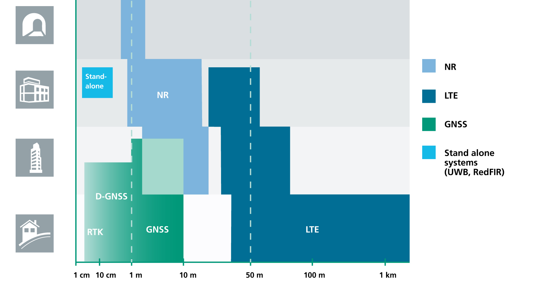
    5G NR enables positioning performance by providing high bandwidths for precise timing, new frequency bands at mm-wave, massive MIMO for accurate angle-of-arrival estimation and new architectural options that support positioning. Improved levels of accuracy, robustness and latency, not possible today, can soon be achieved, according to Institute. 5G provides fast and reliable access to moving objects, to achieve time-critical process control and optimization in industrial environments not possible with today’s cellular technology. As requirements vary according to the specific use cases, 5G NR will provide a flexible air interface allowing for scalable bandwidths, data rates, latencies, and positioning accuracy levels.

    High-Precision Positioning

    With location awareness becoming an essential feature of many new markets, positioning is an integral part of the system design of 5G mobile networks. Increased contextual awareness of goods, parts, machines and workers will enable new interaction and collaboration.

    High-precision positioning, in the view of Fraunhofer IIS. (Image: Fraunhofer IIS)

    Fraunhofer IIS is working on novel approaches for sub-meter accuracy to enable tracking of mobile devices in indoor and urban areas where GNSS is not sufficiently accurate nor available. Its 5G positioning framework integrate several sensors. The key benefits of 5G in this regard are high accuracy, reliability, mobility and coverage; low latency and low power; and scalability.

    The Institute offers the facilities of its Test and Application Center L.I.N.K. in Nuremberg, Germany. The test center includes a 3D positioning system capable, according to the organization, of reproducing, simulating and emulating all kinds of possible environments, using every common communication and positioning system commercially available.

  • German automakers complete HERE acquisition

    Kevin Dennehy
    Kevin Dennehy

    In what was 2015’s largest location-industry deal, three German luxury auto manufacturers completed the purchase of HERE. But that wasn’t the only recent acquisition as location-based services provider TeleCommunication Systems, or TCS, was bought by Comtech Telecommunication Corp. Both deals indicate the growing, and continued growth, of location services going forward into 2016.

    Three German automakers are now in the location business following the finalization of a $2.8 billion deal to buy Nokia’s HERE digital mapping company last week. Audi, BMW and Daimler are now equal owners of HERE following quick regulatory approval.

    While some say there was much Nokia-driven hype about who was bidding on HERE, including Uber and Baidu, ultimately others breathed a sigh of relief that automotive companies, not Google, bought the digital mapping pioneer.

    The deal, which was originally announced in early August, shows the continued value of accurate maps to the automotive industry as it transitions for connected to autonomous vehicles. In addition, the number of big suitors interested in HERE shows the rise in the potential and real market for location-based services in both smartphones and connected vehicles.

    Many of the early suitors balked at HERE’s early price tag, estimated to be more than $4 billion. Uber, which some felt would be a good match for HERE because of their autonomous vehicle intentions, decided to go in another direction, buying mapping company deCarta.

    While it’s too early to analyze the consequences of the deal, some analysts say it will be interesting to see if the new owners keep the mapping giant neutral to not alienate future clients.

    It remains to be seen whether its competitor, TomTom, which also has been talked about as an acquisition target, should stay as an independent company or form its own consortium.

    Nokia purchased HERE, the former Navteq, for $8 billion in 2007. The sale of HERE is part of Nokia’s transformation as it completes its $16.6 billion acquisition of Alcatel-Lucent, which is expected to close early next year.

    In another big deal since our last column, Annapolis, Md.-based TeleCommunication Systems was acquired by Comtech Telecommunication Corp. for $430.8 million deal. The deal is expected to close in March 2016.

    TCS was one of the first companies to do it all in the consumer location space, buying entities in automotive navigation and also making inroads in the fleet management and indoor positioning/9-1-1 space. The company most recently was developing location technology for mobile, or m-health markets.

    Cyber Security Big Connected Vehicle Concern in 2015

    As we review the past year, one of the biggest connected vehicle trends in 2015 was when cyber security became real for the automakers, said Jon Allen, Booz Allen Commercial Solutions principal.

    “Just as automakers are increasingly demonstrating the power of automation, their momentum is challenged by researchers showing they really can hack into vehicles. While there are engineering challenges ahead to realize the full potential of autonomy, the priority in automotive is to protect the trust of customers and regulators as autonomous capabilities are further developed,” he said. “That puts cyber at the top of the agenda.”

    2016, OEMs will need to further embrace a security mindset, Allen said. “These [cyber risk] issues are solved by designing, engineering and testing your vehicle to meet defined standards. But cyber risk has an outside variable you can’t control: cyber threat actors. This means you’re not just engineering a solution — you’re fighting an adversary,” he said.

    Allen said that automakers need to identify a single leader to champion vehicle cyber security, supporting them up with an integrated, cross-functional team. “That includes experts from safety, privacy, IT, legal, engineering, manufacturing, customer service and supply chain,” he said.

    Autonomous vehicles tout a safety record that far surpasses today’s cars, but a cyber incident has potential to reverse that claim, Allen said. The “doomsday” scenario is attacking multiple vehicles over the air to “brick” multiple platforms, but this may be an unlikely near-term scenario, he said.

    “The near-term attacks will be motivated by money. That’s why many of the largest hacks were designed to exploit personal and financial information,” Allen said.

    At a Colorado Space Roundup meeting in Denver last week, Thad Allen, former Coast Guard commandant and now executive vice president at Booz Allen Hamilton, said that there won’t be a “cyber Pearl Harbor” as the government and civilian entities should have had plenty of warning it was coming. Allen, who was in Denver working on the GPS Operational Control System, or OCX, also said that it would be catastrophic if the GPS infrastructure was compromised.

    “If someone does something to disrupt GPS, it will affect everyone,” said Allen, who oversaw the Hurricane Katrina and Deepwater Horizon oil spill operations.

    Indoor Positioning’s Big Story in 2015: Consumer Appliances?

    While there were several significant tests and infrastructure rollouts, at least one analyst says the rise of indoor positioning in consumer appliances was huge. Bruce Krulwich, Grizzly Analytics founder, said that such companies as Move ‘n See are putting location chips into electronic devices.

    Move ‘n See also has a camera robot, called Pixio, which follows a person moving around a sports field or other indoor site. “What’s huge about this is not the product itself — it’s hard to tell whether it will appeal to the masses or only a niche market–but I believe that it’s the first in a new trend of electronic products that enhance their capabilities by incorporating indoor location technology,” he said.

    In other location news:

    • CalAmp Corp. said it made a $113 million offer for LoJack Corp., which is a pioneer in car theft-recovery using location technology. According to published reports, CalAmp has made three cash offers for Lojack in the past 14 months. LoJack’s car recovery systems use location technology, which seems to be a great fit for CalAmp, which offers fleet tracking software.

    It’s been a good run. After eight-and-a-half years, this is my last Wireless LBS Insider column. Many thanks to Alan Cameron and Tracy Cozzens, both seasoned journalists, who steered me on the right course over the years. I will be at CES in a freelance role next month and will continue to operate my autonomous vehicle conference, Driverless.

  • What to expect from the Consumer Electronics Show

    What to expect from the Consumer Electronics Show

    A scene from the hectic and high-tech show floor of CES 2015.
    A scene from the hectic and high-tech show floor of CES 2015. (Photo: CES)

    It won’t be long until the January Consumer Electronics Show (CES) overwhelms us, so I want to ensure that we don’t overlook innovation occurring now, both in mapping and in automated vehicle technology. And if you are attending the show or following its news, I will provide you with a heads-up that will help orient you.

    what3words. GPS has revolutionized mapping and burst open a host of technologies. We have lived through a transformative age, but today, new features are mostly iterative, just a bit better than last year. A UK startup, what3words, is providing an intriguing perspective on geolocation, mapping the world by words instead of long number strings of location coordinates.

    what3words has divided the world into 57 trillion nine-meter square tiles, each randomly assigned a unique string of three words and, yes, that’s a big vocabulary. For instance, Strawberry-Cart-Walk might be the name for a patch of soil in Africa, and Flower-Hay-Pen might designate a square on the sidewalk in Manhattan. The words have no context, but provide the advantage of being easier to remember, communicate (particularly vocally) and may be less prone to error.

    The advantage of worded geolocations is more apparent in places that are mapped poorly, and have inadequate addressing or limited technology. This describes most of the world, where water wells in remote places can’t be found and aid has trouble reaching people that lack a way to communicate their location. Even in well-mapped areas, worded geo-location can be helpful by identifying specific locations at a traditional address, such as goods and vehicle entrances as well as front doors. How many times are we told by a nav system that we have arrived at our destination when the entrance or driveway isn’t in sight? what3words has recently signed a deal with Esri and has received a Series A investment round.

    Google’s Latest Patents. The race to owning the connected car has been a marathon, and the smartest companies have focused on developing intellectual property that can be patented. Google is in the lead, and most recently the company was granted a patent regarding the interaction between a vehicle and a pedestrian. Self-driving vehicles by necessity are overly cautious or may overreact to road “obstacles.” They are disadvantaged by not being able to interact like a human driver, who might nod or frown or gesture to a pedestrian to indicate intent. Google was recently granted a patent for automated vehicles to communicate intent with a pedestrian, via a physical signaling device, an electronic sign or lights, or a speaker for providing audible notifications. Signage on the vehicle might illuminate to indicate that the vehicle will stop at a crosswalk and that it is safe for the walker to proceed.

    Innovations Unveiled. The CES Innovation Awards are given prior to the show. Bosch is a 2016 winner for a new in-vehicle touch screen that provides haptic control. The screen recognizes the pressure applied by fingers and activates functions accordingly. Having recently announced that it is entering the auto component market, expect different offerings from Samsung. Anticipation is growing that Faraday Future, a new automaker planning to go head-to-head with Tesla, will unveil a concept car.

    Innovation will abound at the Consumer Electronic Show in Las Vegas. Look for the most exciting technology announcements in automotive and virtual reality technology. CES in expanding automotive exhibit space by 25 percent to fit 100 automotive technology companies and nine automakers. Virtual reality and robotics will both have a much stronger presence this year. In addition, the evolution of smart homes, wearables, drones and mobile health technology will be interesting to watch. And if you want see the next trendsetters, check out the curated area of 500 startups. That is the real barometer of the future.

    If you are interested in the connected vehicle, attend the conference Driverless, the Business of Autonomous Vehicles, which will be held March 22-23, 2016, near the San Francisco Airport.

    This is the last issue of Wireless LBS Insider. For six years I have been the editor of GPS World’s newsletters Wireless Pulse and then Wireless LBS Insider, to provide perspective on location-based trends. My coverage started with the beginnings of E-911, telematics and location-based services (LBS) and expanded into connected vehicles, location-based advertising, and M2M.

    As an industry insider, I have a consulting practice devoted to helping companies shape new offerings, research new markets, take the temperature of customers, develop new business and communicate the value of their offerings. Let’s keep in touch. Email me at [email protected]. And if you happen to be at CES, we can meet and talk technology.

  • Why Did Google Scrap Its Location Service?

    Why Did Google Scrap Its Location Service?

    Reasons Cited Include Privacy, Lack of Retail Support

    Kevin Dennehy
    Kevin Dennehy

    Google Here, a proposed beacon-based location service operating within Google Maps, was reportedly cancelled due to a concern by Alphabet CEO Larry Page’s that it would be too invasive by the users of his mapping service. When the location industry has such a dominant player pull out of a nascent, and potentially lucrative, proximity service, does it mean that consumers will now have to wait for a full-scale rollout? Google will remain a major player with its Google Maps app, but where does it go from there?

    Citing privacy issues and lack of retail partners for support, Google scraped its Google Here location service that would have used the company’s Maps technology to send notifications to users when they entered a specific location.

    In a recent Fortune article, Alphabet CEO Larry Page said the company killed the project because it was too invasive to consumers, and the company was uncertain whether retail partners could have helped to roll out the service. Besides being in conflict with an existing location Here name (such as the former Nokia, and now German consortium, mapping service), the service included partnerships with retailers — and would have been available to more than 350 million Android users earlier this year.

    Google makes money off of advertising through its Maps app, but the Fortune article said that the proposed Here location service would have made it even more valuable to advertisers.

    So what does the location industry make of one of the largest players not rolling out a location service? To at least one analyst, it’s a “so what” report considering Google in July rolled out a new agnostic beacon service called Eddystone. “Somewhat curiously, the company appears to be moving forward with location-based advertising under the guise of the Eddystone project, so beacons and their use in location-based advertising seem still of interest — just not beacons combined with messaging that might make Google Maps an uncontrollable nag about shopping opportunities,” said Mike Dobson, Telemapics president.

    Eddystone, a new format for Bluetooth Low Energy beacons, works with Google’s Android operating system along with Apple’s iOS and other platforms that connect through BLE.

    Overall, Dobson believes that Google is approaching middle-age in terms of corporate development. “It is both developing a conscience about how its services really operate, as well as imposing economic constraints limiting how much the company is willing to spend to determine whether a potential market might be a big hit,” he said. “More specifically, it is my opinion that Google is slowly reining in the spending on new innovations for Google Maps, as well as the expenses associated with supporting the lakes in the data reservoir associated with their mapping product. Google may have finally realized that maintaining spatial data is expensive and a cost that is never going to decrease.”

    Dobson also said that the Google Here program was going to be an expensive proposition. “My understanding of the Google Here program was that Google would provide the beacons and infrastructure and control delivery of the service through Google Maps. That’s a lot of beacons and associated support — in other words, more money,” he said. “Conversely, Eddystone appears to offer a standardized, industry-supported approach that is beneficial for Google and companies interested in testing the concept.”

    Dobson said the name “Here” could have caused problems for Google. “Two other issues crossed my mind when I heard the news of the cancellation. First, who at Google forgot trademark law and thought they could combine the name of the well-known mapping company Here with Google?” he said. “Second, if I owned an application as successful as Google Maps is on mobile phones, I sure would not want to push my users to consider switching to a less-invasive mapping app. You know, that Larry Page guy sure seems to know his Alphabet.”

    Big Competitors Getting into Beacons, with Huge Market Expected

    Recent Allied Business Intelligence reports indicate that BLE beacon shipments will exceed 400 million units by 2020. While optimistic, and only five years away, ABI said that pure beacon shipment revenues will break $1 billion this year.

    Google’s July entry into the location-beacon space is significant, if not surprising, to heat up the location market. However, competition is fierce as Apple, Facebook and Twitter now have dedicated BLE resources.

    The location-beacon market is heating up as Gimbal, the Qualcomm spin-off company, installed approximately 1,300 BLE beacons in areas at South by Southwest. Gimbal said it was making its technology available to enable any BLE device to act as a dedicated location beacon.

    Google plans to improve its own products and services through the Eddystone beacon technology, according to a company blog. Earlier this year, the company launched beacon-based transit notifications in Portland that enable users to get faster access to schedules for specific locations.

    With rise in commercial location-based beacon technology comes a cross-over movement in public safety markets. TeleCommunication Systems, which bought Loctronix in July, is developing the indoor public safety and emergency market, along with Longmont, Colo.-based Intrado.

    As detailed in last month’s Wireless LBS Insider column, beacons and Wi-Fi seem to be the lead technologies in use for emergency indoor location. Intrado installed 65 Apple iBeacons at the Washington Convention Center to showcase its developing indoor positioning technology at the APCO trade show.

    It’s not all about beacons in this proximity/contextual location market. The analytical data derived from the beacon information will grow into a huge market. As we reported this summer, a new location analytics product is hitting the market in a more and more crowded indoor-positioning field.

    Such companies as Cloud4Wi, with its Fogsense product, is tailored to retail outlets, coffee shops, restaurant chains and shopping malls with presence analytics and location-based services.

    The device, which contains Broadcom’s WICED chip, features BLE technology in the new version in (the fourth quarter), said Elena Briola, Cloud4Wi’s chief marketing officer. The new BLE version will enable Apple iBeacon and location-aware mobile applications, the company said.

  • Phones Allow Surreptitious Geo-Tracking

    Phones Allow Surreptitious Geo-Tracking

    Janice Partyka
    Janice Partyka

    Not everyone wants to be located. Consumers think they have the ability to turn off the tracking ability of their phones. But can they? More about that later. In other news, there are good reasons why Nokia’s HERE mapping is still on the selling block. And blind people are using a no-tech version of a widely used location positioning method that doesn’t need canes.

    The controls that phone makers have devised to enable consumers to opt out of being located have a big hole. Android-based phones are giving app makers free access to phone data that can be used to surreptitiously geolocate devices. The data comes from an unlikely source: power consumption, and no consent is needed.

    The technique, called PowerSpy, was developed by researchers at Stanford and Rafael, Israel’s defense research group, and gathers a phone’s power usage history. Simplistically, the location of the phone is tracked by using the phone’s battery consumption to determine the distance of a phone to a cell tower. The further the distance, or the greater the obstacles blocking the tower, the more power is consumed by the battery. The researchers say they can take into account phone usage battery drain and filter out the noise created by focusing on long-term trends.

    At its current level of development, the PowerSpy method requires the snoop to have driven a route (war driving) to identify its power consumption pattern. With tests conducted in San Francisco, the method worked with 90 percent accuracy to identify a correct route from seven choices. The team is working on using the data to detect unknown routes that have not been previewed.

    How would the hypothetical stalker, crook or unethical mobile advertiser get access to this data? They would entice a person to download an app. The smoke screen app might be a game or a productivity app that is quietly slurping up the power consumption data.

    Here Today, Not Gone Tomorrow? Wouldn’t you think that Nokia would by now have clinched a deal to sell the mapping division? Given its mapping debacle, Apple was on the top of everyone’s list as a buyer, but apparently the company didn’t even participate in the bidding, and instead is committed to further development of its self-built mapping database. Contenders — Facebook, Baidu, Tencent and Uber — seem to have dropped out of the competition. Left is a consortium of German automakers — BMW, Daimler and Volkswagen — who feel that they should get a better deal with no other buyers in sight. It is a double-edged sword, as they also worry that if the highly accurate maps are acquired by tech firms, the car makers will lose a competitive advantage in the fight for supremacy of the automated vehicle. High-precision mapping is critical to the success of the auto OEMs.

    Who Will Win Connected Vehicles? Follow the Money. Investors who want a piece of the connected vehicle action are placing bets on the tech companies, not the auto OEMs. Many blue chip and small companies are seeing healthy gains in price. Sensor chip makers, car infotainment and telecom companies are some of the winners. With the surge of connectivity required in the Internet of Things, networking technology will also do well.

    E911 Innovations. While regulations are in place for eventually requiring technology to automatically identify the location of indoor E911 calls, dispatchers don’t yet have that capability. Callers can be inside a large complex, like a dormitory or hotel, and if they are unable to speak or identify their location, response is hampered. Smart911 from Rave Mobile Safety is sending dispatchers floor plans of buildings to help in rescue efforts. The maps are automatically sent with the 911 call and have already been credited with quicker responses.

    Quick Business News. Uber acquired Microsoft’s geo-imagery team and assets, known at BIT (Bing Imagery Technologies), which is based in Boulder. Microsoft didn’t need this technology as it had already outsourced Bing Maps technology to Nokia HERE. Telecommunication Systems (TCS) purchased location-based technology and intellectual property from Loctronix. The purchase will further TCS in developing indoor-location technologies. Denmark has become the first country to use real-time traffic data across a national network. Denmark will use GPS probe data managed by INRIX for congestion management. The Internet of Things relies on multitudes of sensors and a new start-up, Sense360, has built a platform to manage that data.

    No-Tech Location Technology. Daniel Kish was a particularly helpful kid who made deliveries for his mom to homes outside of his neighborhood. What is unusual is that Kish is blind and uses echolocation to “see” the space around him. He clicks his tongue to ascertain the unique echoes of his surroundings, starting by identifying areas of high or low density, such as tall buildings, squat houses or open space. And in a version of drive testing, blind users like Kish first walk a neighborhood with a sighted guide and remember the signature echoes. Whether it is solely by ear or with a big computer algorithm like PowerSpy, pattern mapping can be effective.


  • Autonomous Vehicles Face Privacy, Security and Liability Issues

    Chris Urmson, Google, speaks at ITS America on the future of the self-driving car.
    Chris Urmson, Google, speaks at ITS America on the future of the self-driving car.

    Plus: Resurgence in indoor location-based marketing, ITS America annual meeting report

    Autonomous vehicle technology has made industry-smart people pause and think what the consequences will be if cars and other platforms drive themselves. Will there be a huge increase in traffic when everyone decides to call their cars to grab a loaf of bread at a store? Many of these topics were discussed at the ITS America annual meeting held in Pittsburgh May 31-June 3. In other location news, there seems to be a resurgence in location-based marketing and indoor positioning conferences, leading one to believe that large retailers are finally taking notice.

    By Kevin Dennehy

    Kevin Dennehy
    Kevin Dennehy

    PITTSBURGH — Chris Urmson, Google’s self-driving cars director, told autonomous vehicle proponents what they wanted to hear during his keynote presentation at the recent Intelligent Transportation Society of America’s annual meeting here. He told them that self-driving vehicles will cut down on the 33,000 U.S. traffic deaths each year (“the equivalent of a 737 falling out of the sky five days a week,” he said) and save time and productivity wasted.

    Urmson also said his goal, and his team’s goal, at Google was to ensure son doesn’t have to get a driver’s license, a trend that has become popular with urbanized youth.

    The message was upbeat and timely for the crowd of government and university transportation attendees. However, liability issues continue to surround autonomous vehicle development.

    “In the end, you are always going to have that guy with the ’57 Chevy in his garage. How do you make the autonomous vehicle work with it? It’s akin to the horse and car,” said Ken Leonard, U.S. Transportation Department ITS Joint Program Office director.

    Urmson said he has had “long conversations with insurance companies.” He said that insurance companies are trying to accurately assess risk, and while the model may change, money will still flow, just through a different path.

    One ITS America panel discussed security and privacy issues surrounding connected and autonomous vehicles. One panelist said that while privacy may be dead, security is the real big deal with recent reports indicating that cars’ electronics can be compromised.

    Others believe it’s going to take more time than Google’s assertion that autonomous vehicles will be on the road in five years. “Lessons from the past temper our optimism. While air bags were patented in 1953, and were introduced on luxury models in the 1970s, it wasn’t until the 1990s before there were big penetrations,” said James Anderson, Rand Corp. senior behavioral scientist. “Key takeaways are automaker opposition about the liability [of new technology] and lack of consumer support.”

    The ITS America show floor before the crowds arrive.
    The ITS America show floor before the crowds arrive.

    Anderson said that yes, the lives saved will be a big driver of autonomous vehicles, but congestion will increase, making way for super commuting. “Public transit will also go through big changes. An economic disruption will occur — do you know how much New York City makes from parking alone?” he said. “Safety doesn’t sell in the early stages, as many benefits don’t go directly to the user.”

    Steve Bayless, ITS America vice president of technology, said the solution is not to kill all the lawyers, as there will be continued liability surrounding new in-car technology. “Embedded devices were developed at a time when they were not connected, but the environment has shifted around systems,” he said. “The systems are usually vulnerable because there are poor requirements. Companies have no explicit security policy, or it is poorly specified, or specified too late after design and development.”

    Uber Gets Into Autonomous Game

    The ITS America’s closing keynote speaker was Uber’s head of global public policy, Corey Owens, who said that one of the best cases for autonomous vehicles was the lack of use by consumers of their cars. “In some areas, owning a car is non-negotiable. But how little these cars are used — as many as 95 percent stand idle,” he said.

    Uber announced that Google former head of mapping, Brian McClendon, is joining the company as it develops its own navigation, mapping and transportation systems.

    It’s no secret that Uber is targeting continued autonomous vehicle interest, as it created an Advanced Technologies Center in Pittsburgh. It was also rumored that it was a bidder, with Baidu, to buy Nokia’s HERE digital mapping company. (See more on Baidu in Janice Partyka’s June blog.)

    One major company trying to find its way into connected vehicles, Xerox, exhibited at ITS America in the show’s Entrepreneurial Village. Xerox has installed its smart parking products in such systems as LA Express Park, ParkyIndy and others.

    Xerox has partnered with the University of Michigan Transportation Research Institute in Ann Arbor for testing connected and autonomous vehicles. The company is working with automotive OEMs on electronic tolls, parking, mobile payment and other projects, said David Cummins, Xerox senior vice president and managing director of parking and mobility solutions.

    The U.S. Department of Transportation booth at ITS America focused on the connected car.
    The U.S. Department of Transportation booth at ITS America focused on the connected car.

    Cummins moderated a panel where small companies talked about new technologies and applications like cities without bus stops where a bus is continually moving to the riders on demand.

    In terms of autonomous vehicle use, Cummins envisions an increase in ride-sharing over the next 5-10 years in urban areas. “Initially, there will be a spike in congestion [from autonomous vehicles]. But ultimately, there will be less car ownership,” he said.

    Thoughts on ITS America’s Annual Meeting

    ITS America celebrated its 25th annual meeting in Pittsburgh to an enthusiastic crowd of 2,000 attendees and 125 exhibitors. However, I am not sure if this conference has grown at all, despite claims it had the largest attendance last year (co-located with the larger, and more private-company-friendly, ITS World Congress in Detroit).

    Despite two decades of rhetoric that it is a private-public partnership, the meeting has the feel of a government and university gathering with a few private companies thrown in who want to do business with them. This is a sad thing, as ITS America has embraced the future of autonomous vehicles with excellent speakers.

    Having the meeting in the Bay Area next summer will be a good start to altering the perception that ITS America’s annual meeting is just a government show to “show-the-flag” for private companies.

    Mid-Year Report on Indoor Location

    Earlier this month, executives attended the Place Conference in New York to get an update on indoor location markets and technology for store chains, large department stores and malls. It was also a chance for technology vendors to show new capabilities that have recently reached the market, said Bruce Krulwich, Grizzly Analytics president, who has authored a report on 150 indoor positioning companies.

    Krulwich said, as the year reaches it’s the halfway point, new and more accurate systems are hitting the market. “This includes LED lighting-based systems from Acuity and GE Lighting, and proprietary radio technologies from companies like Quuppa, all of which deliver accuracy of around 10 centimeters with very fast response,” he said. “Some companies, including New York-based Spreo, are improving the quality using standard approaches, like beacons and motion sensing. They are achieving strong accuracy and responsiveness through software improvements. At the same time, hardware-based indoor location technologies, such as Ireland-based DecaWave’s chip and other UWB systems, are coming to market inside highly innovative consumer devices.”

    Going forward, the biggest challenge is moving from the lab to the real world, Krulwich said. “Deployments such as Game Stop stores and Taubman malls are great moves in this direction,” he said.

    In other location industry news:

    • Note to meeting organizers: Do your due diligence to ensure conference dates don’t overlap. Having two major transportation conferences on the same week was challenging to attend: ITS America Annual Meeting and Telematics-Detroit.
    • The brass at Nokia continue to court a consortium of German car makers to buy its HERE navigation business, according to Bloomberg. The consortium, which consists of Audi, BMW and Daimler, is hung up on the price tag of $4.5 billion — and the deadline for bidders has passed, according to the story.
  • Will China Win the Automated Vehicle Race?

    Janice Partyka
    Janice Partyka

    By Janice Partyka

    The race for the automated vehicle is on. This time, it’s not about whether automotive OEMs or tech will own the vehicle. It’s a battle between Baidu, China’s web giant, and Google, and it isn’t clear who will win. Baidu has announced it will launch an unmanned car in the second half of this year. Despite speculation that Baidu will be working with BMW, Baidu hasn’t announced its automotive partner. The Baidu vehicle will provide the flexibility of some conventional controls, such as pedals, coupled with automation, unlike Google’s approach of being completely autonomous, without pedals and steering wheel.

    One of the most practical uses of artificial intelligence is in the automated vehicle, as cars need to recognize and sort images they “see,” and make quick safety decisions. In a recent TED talk, Chris Urmson of Google revealed a few of the unusual things that Google cars have had to process while driving. The cars have successfully encountered a woman in an electric wheelchair chasing a duck on the road and a child driving a toy car in the road. I wouldn’t be surprised if there are some even weirder encounters that Google is shielding us from.

    Artificial intelligence is critical to the automated vehicle. This year Baidu won a prestigious international artificial intelligence competition at Stanford, but was just stripped of its title and barred from competing in 2016. Apparently, the Baidu team broke the rules on how many tests they could run. In the competition, computers had to recognize and sort images and classify objects into 1,000 different categories. The teams were allowed to run a limited number of tests to train their programs on identifying objects. The Baidu team exceeded the limits by submitting their program using different accounts. In an article in the New York Times, Jitendra Malik, an expert in computer vision, compared the actions of the Baidu team to drug use during a sports competition. “If you run a 9.5-second 100-meter sprint, but you are on steroids, then how can your result be trusted?” Malik said.

    Automated vehicles aren’t the only location market Baidu is aggressively pursuing. With technology from IndoorAtlas, Baidu has rolled out indoor location to 270 million active users of its map application. The solution uses mobile device technology to create geomagnetic maps of indoor places to enable indoor search and to power store and product search, as well as way-finding. A physical map of a building is uploaded into an app on a mobile device, like a smartphone. Using the app, a person walks all corridors in a building, thereby adding location positioning and creating a map.

    Let’s return to the topic of automated vehicles. Earlier this month, Uber suffered a blow when the California Labor Commissioner’s Office ruled that drivers are employees and not contractors, and therefore need to be so compensated. Taxi and limo services had been hurt by services like Uber, and they pressed for redress from what they felt was unfair competition.

    Like Uber, the automated vehicle market will likely hit intense push-back from a number of industries that will be disrupted. These include insurers, taxi and truck drivers, and personal injury and traffic litigation attorneys. These groups may try to build regulatory roadblocks for automated vehicles. And as their businesses may suffer, the automated vehicle industry needs to think now about how to mitigate the damage and create allies. With a completely different political process, Baidu may encounter no such resistance in China — quite an advantage. Perhaps Baidu will be first out of the gate, but may not be the long-term winner. Think Ford Sync.


  • Nokia Selling HERE, Indoor Location Intensifies

    Janice Partyka
    Janice Partyka

    It has been an interesting month for developments in location. Nokia is looking for a buyer for HERE, the mapping and navigation business that once set the industry gold standard. While carriers are planning how they will comply with new FCC mandates for locating indoor E911 calls, the commercial indoor location market has moved beyond “emerging” and is well underway. It is a confusing ecosystem for buyers of indoor location solutions. And there is yet another mega-entry into the connected vehicle market, Alibaba and China’s SAIC Motor.

    With the likely merger of Nokia and Alcatel-Lucent, Nokia has started looking for a buyer for its digital map and LBS division. The mapping industry has changed dramatically since Nokia purchased the mapping leader Navteq in 2007. Google has become a mapping juggernaut, and less accurate free maps have become serviceable for many types of uses. In fall 2014, Nokia took a EUR1.2-billion impairment charge on HERE’s book value and now estimates the fair value for HERE at EUR2 billion. Possible buyers include Google, Microsoft, Apple and Uber, all companies with deep pockets and hardy appetites.

    Indoor Location Market Is Messy. The indoor location market is pulling away from the station, as technology is ready and there are applications and use cases primed to get started. Unfortunately, the market is chaotic, teaming with companies offering solutions with various levels of accuracy, infrastructure requirements and cost. An ideal indoor location technology would provide at least 3-meter accuracy, be cost effective and fully universal, working anywhere on all devices. It doesn’t exist, but the competing technologies, all with trade-offs, will find applications that fit. For instance, the precision required in locating an apartment in the case of an E911 emergency call differs greatly from the pinpoint accuracy need by an app that directs a shopper to Lucky Charms cereal on an aisle crowded with boxes.

    One Size Doesn’t Fit All. There is more to an indoor location technology than accuracy. “Accuracy is important, but so is universality, the ability to work everywhere and in all phones. So is cost, in terms of the investment required from a site deploying the technology,” asserts Bruce Krulwich of Grizzly Analytics. “Universal technologies can win in the market even if they’re less accurate, and technologies with cheaper infrastructure can win even if they’re less accurate than those with expensive infrastructure. High-end systems can deliver sub-meter accuracy to those willing to pay for it.” Grizzly Analytics just completed a comprehensive report on the indoor location market.

    Test First. Each of the numerous companies vying for the indoor location market makes claims regarding accuracy, availability/coverage, latency and battery usage. Judicious companies that invest in indoor location systems would be wise to test the claims of vendors. “Making a fair comparison among different indoor location offerings is complex, and nuances in how the testing is performed need to be controlled to ensure an apple-to-apple comparison,” asserted Khaled Dessouky of ComVerity. “It is important to use an unbiased methodology that relates to your use cases.” Dessouky managed the neutral test bed for the FCC’s Communications Security, Reliability and Interoperability Council (CSRIC) for indoor E911 calls.

    Quuppa. An interesting highly accurate offering comes from Quuppa, a Finnish company with a bunch of high caliber researchers spun off from Nokia. Like some others, they are using Bluetooth Low Energy (BLE) beacons, but add angle of arrival (AOA) algorithms that pump up the precision, which they self-report to be 30 centimeters to 1 meter. With this performance, Quuppa has been used in sports to track hockey pucks and athletes’ movements during game play for coaching, player load monitoring and infotainment that can be broadcast during the game. The use of this type of high-precision location in health care settings is compelling. Patient flow management, security and critical asset tracking can be improved with precise positioning technology. Quuppa is a system that likely wouldn’t be used in apps that locate a coffee shop at a mall, but for uses that demand high performance and can spare some expense, it is compelling.

    And Yet Another Mega Entry. The number of companies vying for a piece of the connected-car market keeps expanding and getting more international. E-commerce giant Alibaba and SAIC Motor, China’s popular car maker, together set up a $160 million fund to develop “car on the Internet.” Alibaba will be leveraging its communications, entertainment, map and cloud-computing services. The company joins a group that includes Google, Apple, Baidu and Uber in challenging auto makers.

  • Drones Take Off for Location Companies

    Drones Take Off for Location Companies

    3D Robotics Solo Drone with GPS embedded.
    3D Robotics Solo Drone with GPS embedded.

    The National Association of Broadcasters meeting in Las Vegas draws 100,000 attendees annually, making it one of the largest trade shows in the country. However, besides timing and some very niche markets, it has not been a big show for location companies. That is, until now, when NAB welcomed drone manufacturers, all of which embed GPS in their flying aircraft.

    Kevin Dennehy
    Kevin Dennehy

    LAS VEGAS — Commercial drones, a growing market for location companies, was one of the most popular topics at the National Association of Broadcasters Show, held here April 13-16.

    The market for drones has grown nearly five times in the last few years, said Eric Cheng of DJI, which uses GPS in its virtual positioning system that monitors and controls the aircraft. The company markets what they call “flying cameras” that look suspiciously like drones. “The market was initially hobbyists, but now some major broadcast players are buying the cameras,” Cheng said at the Showstoppers trade event the day before NAB.

    Most of the drones offer GPS-based automatic flight stabilization technology. Some even offer a long-range wireless signal and low-latency video transmission.

    Many of the drones are programmed so they don’t go higher than mandated FAA rules or go into restricted, no-fly aviation zones — and all use GPS to do this. Some of the drones even return to the user automatically when their batteries run low.

    DJI drone with embedded GPS.
    DJI drone with embedded GPS.

    DJI offers three cameras for the drones. The high-end Phantom 3 Advanced offers 1080P HD video at 60 frames per second. The 1080P version costs $995.

    In terms of privacy and government regulation, U.S. regulators are way behind Europe, Cheng said. “Other countries are way ahead of the [United States] in terms of working with drone companies,” he said. “In terms of privacy, the step ladder was the first tool for the invasion of privacy. They haven’t outlawed step ladders.”

    The slow U.S. regulatory process has forced some manufacturers to go to other countries to test their drones, said Roger Sollenberger, 3D Robotics’ editorial director. “[U.S. regulations] have moved slowly here — despite the government knowing about worldwide drone rollouts. In Japan, they have been using drones to crop dust for 20 years,” he said.

    Furuno's Don Hanham with GNSS modules at NAB.
    Furuno’s Don Hanham with GNSS modules at NAB.

    To signal increased interest in the commercial drone market, 3D Robotics raised $70 million dollars in funding, led by investor Qualcomm, Sollenberger said. The company, which partnered with action camera giant Go Pro, says its Solo drones can be used not only by broadcast companies, but for railroad track and building inspections.

    As GPS World reported, Furuno Electric Co.’s latest multi-GNSS receiver module, GN-87, has been adopted for the new quadcopter Bebop Drone. The broadcast market has been a good one for company’s timing products, drone integration and even weather prediction, said Don Hanham, a Furuno sales and marketing consultant.

    Furuno is marketing its Doppler Weather Radar System for broadcast. The system allows weather predictors to follow the development of short, localized rainstorms and extreme weather conditions.

    Booz Allen Hamilton Releases Report on 2015 Automaker Priorities

    The era of automotive connectivity, and subsequent heavy competition, is the focus of Booz Allen Hamilton’s new report, “Getting the Customer Experience Right: Auto Industry Priorities in 2015.”

    The company says that automakers should consider six key priorities this year: deliver innovation in months, not model years; differentiate with new partnerships to catch customers’ attention; secure connectivity to reinforce a relationship of trust with customers; address the “so what” of connected cars; personalize the customer experience via the tremendous potential buried in data; and find and build the market for alternative fuel vehicles.

    In terms of big connected vehicle technologies this year, Jon Allen, a principal with Booz, cites 4G pipe in GM and Audi vehicles and over-the-air updates by Ford and BMW, among others. “New parental controls in the Chevy Malibu report average speed and near misses while also preventing drivers from turning on the stereo until seatbelts are fastened. It’s easy to imagine this across vehicles, with parents receiving text messages in real time,” he said.

    Allen said, in terms of vehicle connectivity, automakers must answer the “so what” to set themselves apart from the competition. “We have yet to see the seminal, game-changing connectivity plays. Most companies are still in the ‘features’ mindset, offering new à la carte enhancements,” he said. “They’re not yet articulating a top-down strategy for re-envisioning the customer experience with connectivity.”

    One of the company’s six priorities concerns connected security, which has been a big industry issue since the recent release of the Markey Report, which focused on how vehicles can be hacked. “We have clients who get it.  They’ve identified a senior leader to champion vehicle cyber security and backed them up with a cross-functional team that works closely with counterparts across the organization — in product engineering, supply chain, safety, privacy and IT,” Allen said.  “Other OEMs are still formulating their approach. That said, there are pockets of cyber security across every organization, focused on implementing security controls on individual parts. The challenge is taking the next step —moving from this segmented, ‘assembly line approach’ to a more unified program that focuses on securing the complete vehicle ecosystem.”

    Allen said the company has to speak honestly to customers and regulators about how to manage vehicle cyber security risk. “Industry leaders must prioritize their security approach to ensure that higher risk scenarios are addressed first, rather than try to take on all elements of the challenge at once,” he said.

    Another priority addresses the long lead times, by automakers, to develop and roll out new features, which is a challenge, Allen said. “Consumer electronics, telecommunications and software companies are redefining the traditional industry boundaries that once distinguished them from OEMs. These companies focus on connectivity and services from the start of their product design process,” he said. “The key for automakers going forward is to continue learning from these new competitors, particularly around rethinking the vehicle lifecycle, connected product design, and managing vehicle software updates after purchase. In the near future, automakers will need different approaches to building and enhancing infotainment systems that can keep pace with customer demands.”

    The marriage of autonomy and connectivity is a game-changer, Allen said. “It isn’t just about plugging vehicles in to the Internet of Things. Autonomy transforms transportation,” he said. “When a car drives you, it becomes a retail outlet, a personal assistant, even a trusted chaperone — that all depends on getting both autonomy and connectivity right.”

    The rise of autonomous vehicles gets to the fundamental need for industry leaders to be willing to reimagine their product, Allen said. “Autonomous capabilities are not just about engineering a safer, more efficient, and more appealing mode of transportation. That’s important, but it’s really about a distinctly different product, one that creates a sustained, services-based relationship with the customer,” he said. “It will focus on the driving experience not just behind the wheel, but sitting comfortably inside of a self-driving vehicle. The connected, autonomous vehicle will change automotive for the better — and forever.”

    Allen said his company is seeing OEMs look beyond their individual vehicles to see the emerging connected society that includes ride sharing, multi-modal transportation and connected cities. “The way we go from point A to point B will look and feel drastically different 25 years from now; many OEMs are beginning to accept the change and embrace the challenge,” he said.

  • Mobile World Congress Sees Rise in Indoor Location Companies

    Kevin Dennehy
    Kevin Dennehy

    This year’s Mobile World Congress in Barcelona was the biggest ever, with 95,000 attendees and thousands of booths, conferences and people with sore feet walking a cavernous exhibition hall. While the Geneva Auto Show ran close to the same dates, connected vehicle companies and technology were prominently featured. What was interesting, however, was the rise of indoor positioning companies and mobile advertising agencies with interest in location.

    BARCELONA — Joining the 95,000 or so Mobile World Congress attendees were about three dozen companies who are offering indoor location and location advertising services. These companies have exhibited at previous conferences, but not in the numbers this year.

    At the huge Fira convention center where MWC was held March 2-5, Los Altos, Calif.-based Pole Star installed more than 600 beacons for indoor location. Visitors were able to be guided to booths and other areas through an interactive map. “Business was good in 2014, we sold 10,000 beacons. We are making money,” said Christian Carle, Pole Star CEO.

    One analyst said that the big change at MWC wasn’t the number of indoor positioning companies and demos, but the maturity and breadth of the technology. “Intel announced indoor positioning capabilities in their Wi-Fi chip, and had a demo that was very impressive. Many smaller companies that in past years were showing raw technology were showing polished solutions this year, such as Quuppa, MTI and Sensewhere, said Bruce Krulwich, Grizzly Analytics president, who has authored a report identifying 150 indoor positioning companies. “I definitely see a shake-out coming up, but it won’t be one technology prevailing over another. Different technologies meet different needs in the industry, and different technologies fit different sites. There are technologies that deliver universal indoor positioning, without any infrastructure or preparation, such as Wi-Fi multilateration and sensor fusion.”

    Krulwich said that there is a shake-out that’s already started because there are too many companies working on similar technologies. “Start-ups in the area that don’t have differentiating innovation, don’t have integration into retail or other back-end systems, and don’t have market penetration, are already finding themselves in a challenge. But companies with clear innovations and commercial deployments will do fine,” he said.

    United Kingdom-based Sensewhere is using crowdsourcing in its indoor positioning software. The software uses radios to scan for Wi-Fi and Bluetooth to allow an IP location to reference the sources and form a location database.

    “It’s what we call the universal indoor positioning versus venue specific indoor positioning, which can work anywhere — we just need a crowd of people. Our target partners are handset manufacturers, network operators, social media, social network providers, and also chipset guys as well,” said Rob Palfreyman, Sensewhere CEO. “So, there are obviously a lot of companies like Google looking at venues; there is Micello and TomTom looking at add-ins in the indoor location, which is great news, but it just needs to have a technology that can drive the blue dot on their map, and we feel that Sensewhere is the right place to provide that blue dot because of the crowdsourcing global nature of our approach.”

    One company, which has developed a popular mobile game, is using its network to attract advertisers for its location-based ad platform. “We already have the infrastructure in place because of our mobile game. With our platform, we can allow advertisers to launch campaigns using our beacon signals and geofencing,” said Pedro Jahara, CEO of Brazil-based RevMob.

    New location technology like the ability to track SIM cards was rolled out at MWC. W-Locate, which is partnering with Morpho in Thailand, is tracking SIM cards with its XimLoc product, which the company said is more accurate indoors than other technology.

    Even such companies as Geotab, which is a strong player in the fleet market, are leveraging MWC to continue a foothold in the European market. The company displayed its IOX-CAN system that can send data from a mobile device to the MyGeotab system, which can be viewed an analyzed by fleet managers, said Maria Sotra, Geotab marketing manager.

    Geotab also partnered with Telefonica in November 2014 to focus efforts in Spain, Germany and the United Kingdom, Sotra said.

    At MWC, location-based advertising market is gaining traction as advertisers are seeing the benefit of locating and attracting customers. New York-based xAd said it has doubled its revenue for the second year. “We have billions of mobile ads processed and billions of ad impressions. The company is profitable,” said Dipanshu Sharma, xAd founder and CEO.

    He said the company has expanded into France and Germany and added China to its global ad network.

    Another company that is using location technology as a differentiator is Airpush, which had another big presence at MWC. The company’s Abstract Banners was a big draw to attendees. Location, particularly geofenced areas, have created a call to action for consumers, which is attractive to advertisers, said Cameron Peeples, Airpush vice president of marketing.

    Connected Car Still Big Opportunity at MWC

    Although the Geneva Auto Show was starting as the MWC was ending, there were still several big announcements by connected car companies in Barcelona. Even the well-publicized Samsung S6 and S6 Edge and HTC One M9 handset rollouts included Mirrorlink, the connected vehicle standard from the Connected Car Consortium.

    In another big announcement, Audi and AT&T said that all 2016 model vehicles equipped with Audi connect will come with the carrier’s 4G LTE or 3G coverage. This increase in services is big because the auto giant just rolled out 4G AT&T service in Audi A3s last year.

    AT&T selected Airbiquity to provide end-user registration and device management connected vehicle services for select customer programs. “Airbiquity will deliver these services to AT&T using our Choreo cloud-based connected vehicle services delivery platform and project management, engineering, and operations teams,” said David Jumpa, Airbiquity chief revenue officer. “This is a ‘white label’ agreement whereby AT&T will integrate Airbiquity’s service delivery capability into AT&T’s connected vehicle customer solutions.”

    Another location company is making huge inroads in connected vehicle markets with its Glympse for Autos product. Glympse will be installed in select Volkswagen and Peugeot models through MirrorLink, said Bryan Trussel, company co-founder and CEO.

    The app allows users to share location from their vehicle by setting the recipient and timer, and hitting send. The company has a similar app for Gogo inflight aviation networks to allow a person on the ground to know where an airplane is for picking up passengers.

    In other connected car news, Accenture is providing Fiat Chrysler Automobiles the capability of in-car, Internet-based services. Starting with the new Fiat 500X, Uconnect Live services, which was co-developed by Accenture, will power an infotainment system that offers music and news services, social network access, the ability to monitor driving style and a range of diagnostic services.

    Accenture also partnered with Visa for an IoT-based connected car commerce test. At MWC, the company tested a scenario where drivers could order food from the car using cellular, Bluetooth and beacon connectivity. Accenture deployed a similar system with BMW’s ConnectedDrive, which allows customers to choose services in real time for a vehicle.

    Health Market Even Has Location Potential

    Niche location applications are growing as Internet of Things, or IoT, markets start to grow. One company taking advantage of the mobile market is Annapolis, Md.-based TCS, which featured its VirtuMedix platform in its MWC booth.

    The platform is tailored to emergency physicians as part of the growing market for video telemedicine products and mobile health, said Jay Whitehurst, TCS commercial software group president. “It’s already saving lives,” he said of the platform, which combines encryption, navigation, mapping and messaging.

    While the product, now being rolled out in a North Carolina emergency medicine group, provides patients with an alternative to urgent care centers and emergency rooms, it also can be used for longer term cases such as assisted living and rehab centers, the company said.

    Whitehurst said TCS has made several company acquisitions that have played a part in new product rollouts, which include the company’s Trusted Location. The application allows financial firms, online gaming companies and others to identify and prevent credit-card fraud. The application identifies and validates a device’s location worldwide.

    In other Mobile World Congress news:

    • Spirent said its simulators have the capability to evaluate Wi-Fi Offload and Wi-Fi performance of mobile devices on its test framework. The new product allows companies to test multiple devices on a single unit to cover Wi-Fi/LTE mobility and interoperability. The testing is important in light of wireless carriers’ strategy to extend VoLTE in areas where cell coverage is limited, said Saul Einbinder, Spirent vice president, venture development.
    • Google Waze said its Google Mobile Service (GMS) will be available as a preinstall option on mobile devices. OEMs and carriers can preinstall the app on their handsets so consumers can use the service immediately, the company said.
    • Trimble’s ALK said its ALK Maps and route visualization software is now available in Europe. ALK Maps, launched in the United States in 2012, allows users to overlay routing, geocoding points, weather and other features, the company said.
  • Markey Report Concerns Connected Vehicle Industry

    Editor’s note: Dennehy is GPS World’s editor for location-based services, writing a monthly column for the LBS Insider newsletter. The views expressed are his own. He will be covering the Mobile World Congress in Barcelona for GPS World. Contact him at [email protected] with your news. 


    Markey-report

    Sen. Ed Markey’s new car technology report, released earlier this month, basically says that connected vehicles can be hacked, causing danger to drivers and presenting major privacy concerns. While some critics believe Markey’s report was meant to drive media hysteria, others say it raises serious issues that the industry needs to address. In other location news, I’ll be covering the Mobile World Congress in Barcelona for GPS World. What will be the showcased location technology? Wearables? Connected vehicles? Or something new? 

    Kevin Dennehy
    Kevin Dennehy

    By Kevin Dennehy

    A report released by Sen. Edward Markey (D-Mass.) earlier this month says that even though drivers have come to rely on new connected technologies, automakers haven’t done their part to protect them from cyber attacks or privacy invasions

    First reported by CBS News’ 60 Minutes, Markey’s report, Tracking & Hacking: Security & Privacy Gaps Put American Drivers at Risk, includes information from 16 automobile manufacturers who were given questions about security and privacy. However, few of the carmakers’ answers included how vehicles may be vulnerable to hackers — and what driver information is collected.

    Location industry veteran Kim Fennell, deCarta CEO, said the report should be a real concern to the industry. “But it’s more of an issue for autonomous driving and the security of the car’s electronic control system. Even today, the OnStar service, which was a pioneer in the connected car space, can remotely slow your vehicle down in the event of a theft,” he said. “This feature, if hacked, could definitely create massive problems if the proper security technologies are not implemented.”

    Markey’s report raised additional concerns about the use of navigation and other features that record and send location or driving history information.

    Markey-telematicsFennell said there should be a distinction between the infotainment systems in the vehicle and the on-board control systems of the car.

    “We believe that there should be a strict firewall between these systems so that nothing malicious can happen that is initiated from the connected infotainment system. Any data should flow one way — from the control system of the car to the infotainment system,” he said. “This is not to say that the connected infotainment system shouldn’t be secure, it should be. In working with our OEM and Tier One partners, we have implemented strict security protocols between our servers and their apps.”

    Markey’s report found that “[automakers] use personal vehicle data in various ways, often vaguely to ‘improve the customer experience’ and usually involving third parties, and retention policies — how long they store information about drivers — vary considerably among manufacturers.”

    In addition, the report found that customers are often not made aware of data collection and, when they are, they often cannot opt out without disabling features, such as navigation.

    Source: Kenvin Dennehy
    Percentage of Vehicles that can record driving history

    Overall, Fennell hopes that the most malicious thing that could happen in the event of a hack of an infotainment system is that a “Pandora station is changed to play nothing but Justin Bieber songs, the traffic information for your route is projected to be ridiculously long or the Yelp rating of the restaurant that you are going to is lowered down to one star.”

    Ultimately though, the driver should be in control of the car and nothing in the infotainment system should affect the behavior of the vehicle, Fennell said.

    In terms of driver safety, in a recent survey, deCarta found that more than two-thirds of respondents considered dashboard screens that display videos and other Internet content to be the most dangerous types of onboard information systems. Approximately 79 percent of those polled preferred “voice-activated mapping systems that allow drivers to keep their eyes on the road” as an essential safety-enhancing feature.

    “There are two things that infotainment systems could do better to prevent driver distraction. First, instead of replicating the stove-piped app store environment of the smartphone, in-car infotainment services could be better integrated,” Fennell said. “If I find a destination on Yelp, I’d like to send that to my navigation system instead of typing in the address. Second, with today’s better automated speech-recognition technology and text-to-speech engines, it’s now possible to make requests of your infotainment system using natural language commands. Voicebox is doing some great things in this area.”

    Fennell said that most existing systems are not connected. “But those that are, aren’t predictive enough. Your navigation/infotainment system should almost work as a concierge,” he said. “It should recognize what time it is and realize you are most likely leaving for work and offer up the best route based on traffic conditions. It should recognize that you are going to a destination in an urban area and offer the most convenient parking to your destination.”

    Company Rolls out Indoor Positioning Product that Doesn’t Require Retailer Involvement

    After testing and demoing the product in San Francisco last year, IndoorAtlas is rolling out a consumer app called GPSindoor, which uses smartphones to locate shoppers inside a mall. The product features product proximity advertising to allow shoppers to see where they are relative to a product for promotion marketing.

    The product includes a crowdsourcing function to allow user-generated data to build indoor maps, wayfinding and other options for shopping promotions, said Wibe Wagemans, IndoorAtlas president.

    “We don’t need any retailers per se. We need only the shopper and [their] smartphone,” he said. “There is no brand or retailer involvement if you use our app. Unlike Wi-Fi and Bluetooth beacons, since GPSindoor relies on a community of shoppers, it allows for higher accuracy than static maps. That gives us the confidence to take on the giants like Apple Beacons and Google Indoor Maps head on — we are completely independent of retailers and not dependent on them for our success in becoming the GPS of indoors.”

    In other location news:

    • HERE released a new version of its mapping system for Android, saying it made significant improvements. According to the company’s blog, after more than 3 million downloads, it is shedding the “beta” label with this version. In the beta version, when users asked for a route, the app gave them three car routes. If a user wanted public transit or pedestrian routes, they had to switch to the appropriate tab. This process was slow and inconvenient for people who don’t use a car all the time, HERE said.
    • In its recent financial statements, Garmin indicated a growing, and profitable, segment is its wearables/fitness band product line. Mio is also expanding its wearable offerings. This should be a big topic at next months’ Mobile World Congress.

    I’ll be covering the Mobile World Congress in Barcelona for GPS World. Contact me at [email protected] with your news.

  • A Milestone in Digital Mapping

    Janice Partyka
    Janice Partyka

    Editor’s Note: Janice Partyka is principal of JGP Services, a consulting practice. She is GPS World’s editor for wireless, writing a monthly column for the Wireless LBS Insider newsletter. The views expressed are her own.

    Hard to believe, we have only now reached the 10th anniversary of Google Maps. As important as digital maps have become, their purpose is much the same as the printed and drawn maps that preceded them. Digital maps emerged in the 1960s with the Census Bureau’s DIME maps. These first digital maps were used for analysis of place-specific data, such as populations within census tracts or cities. Digital maps in turn led to geographic information systems (GIS) for spatial analysis. Though GIS had uses in fields like city planning, the main stimulus for digital maps came in the 1990s with the convergence of the completion of GPS infrastructure, and affordable and portable computers.

    Naturally, just knowing where you are doesn’t have huge value, but if that information can be fused with a digital map, which could generate a route to the destination of your choice, or access information on the places that surround you, then you have something. This is why companies like Etak, Tele Atlas and Navteq began the painstaking process of converting satellite images, printed topographic maps and data that could only be observed with one’s eyes (such as street signs, addresses, speed limits, and turn restrictions) into digital form.

    One of my projects during the 1990s was to compare the accuracy of competing digital maps. It was a tedious process, entailing two-person driving crews traveling each street. The passenger recorded all relevant information and made periodic readings with a large, costly GPS receiver. At the time, digital maps could only be accessed by complicated GIS programs which restricted their usefulness.

    Since then, digital maps have grown in significance due to the advent of smartphones, a growing suite of digital-map-enabled applications, and of course Google Maps. Google has made maps friendlier to developers through its application program interfaces (APIs), which also improved the user experience for scrolling across locations from a map view.

    Google has mastered the process of data capture from roadways. Rather than rely on the eyes of people in the field, sensors and cameras collect mapping data. Image-processing software extracts and geo-codes textual data, automating and enhancing map creation. And Google has incorporated overhead and street-level photographic images into maps, adding substantial value.

    We will never arrive at having a perfect digital map. The work to keep mapping accurate and give it more context will be ongoing. The next challenge in digital mapping is making it work offline and creating accurate maps of the indoors. These next innovations will not be led by GPS, but by sensors, including beacons. GPS has already done the heavy lifting.