Harxon has released a utility beacon antenna — HX-CS7615A — to professionally solve marine satellite positioning challenges.
The HX-CS7615A supports GPS L1/L2, GLONASS L1/L2 BDS B1/B2/B3 and beacon frequencies (282.6 to 326 KHz), which greatly overcomes the defects of long-distance transmission limits, the company said. In addition, combining wide frequencies in one antenna makes the new device more cost effective.
Inside, a multipath rejection board significantly eliminates measurement error, Harxon said. The phase center of the antenna remains constant as the azimuth and elevation angle of the satellites change.
The HX-CS7615A Harxon marine antenna.
The HX-CS7615A is designed with high gain and wide beam width. It is test approved — even in some severe blocking situations, its reception remains stable.
A specialized antenna made for rugged environments, the HX-CS7615A beacon antenna is sealed against water and dust, is salt and fog resistant, and operates in extreme weather conditions.
Housed inside the construction trailer, the RTK Bridge-X with its Ethernet connectivity can physically connect to the internet via an Ethernet cable and then transmit corrections it obtains via both an internal and an external radio, simultaneously.
Intuicom has released the Intuicom 4G LTE RTK Bridge-X Communication Hub for the survey, machine control and precision agriculture markets.
Enhancing the extensive communication capabilities of the standard-setting RTK Bridge product line, the 4G LTE RTK Bridge-X lets users leverage the faster upload/download speeds, the expanded coverage and enhanced connectivity offered by 4G LTE providers including Verizon, AT&T and T-Mobile.
Supporting all leading precision guidance systems and GNSS manufacturers, the 4G LTE RTK Bridge-X is different from less robust modems by allowing users to access, configure and manage their device from their smartphone, tablet or laptop without being connected by a physical cable.
With the 4G LTE RTK Bridge-X, productivity in the field can increase. Key features include:
The 4G LTE RTK Bridge-X by Intuicom.
Faster upload and download speeds.
Access, configure and manage without a cable.
Improved Wi-Fi and internet capabilities.
Enhanced connectivity.
Bluetooth functionality.
UHF and 900-megahertz radio options.
Expanded coverage.
Quicker access to real-time networks.
Ethernet interface for LAN (local area network) connectivity to the internet.
Compatible with all major precision guidance systems and GNSS manufacturers.
Cloud-based remote support available.
“Given the success of the RTK Bridge-X, some manufacturers might be tempted to leave well enough alone, but Intuicom has never been satisfied to sit on our laurels,” says Tom Foley, Intuicom president and CEO. “The 4G LTE RTK Bridge-X further extends our functionality while maintaining our commitment to robust communications in an easy to use device.”
Ethernet interface. Users can take advantage of the device’s Ethernet interface rather than the embedded cell modem to access the Internet. This capability enables the 4G LTE RTK Bridge-X to be connected via Ethernet to a LAN that has internet access, further enhancing flexibility and expanded functionality.
A status update released this month by the Federal Railroad Administration (FRA) underscores the need for railroads to implement Positive Train Control (PTC) as quickly and safely as possible. The update also highlights the Administration’s repeated calls for Congress to provide more significant funding to assist commuter railroads in implementing PTC.
“Positive Train Control should be installed as quickly as possible,” said U.S. Transportation Secretary Anthony Foxx. “This is lifesaving technology available now, and railroads should continue to aggressively work to beat the deadlines Congress has put in place.”
PTC prevents certain train-to-train collisions, over-speed derailments, incursions into established work zone limits and trains going to the wrong tracks because a switch was left in the wrong position.
The status update includes railroad-by-railroad quarterly data as of June 30 on track segments completed, employees trained, radio towers installed, route miles in PTC operation and other key implementation data. Some of this information is also displayed in infographics below. In March, FRA announced that it intended to require railroads to submit quarterly reports to FRA on their progress toward completing PTC implementation.
In 2008, Congress mandated PTC implementation on certain railroad main lines where railroads transport poisonous-by-inhalation hazardous or toxic-by-inhalation hazardous materials or any line where a railroad provides regularly scheduled passenger service. Following a derailment in May 2015 in the Northeast Corridor, in October Congress extended the original deadline from December 31, 2015, to at least December 31, 2018.
“The official deadline for Positive Train Control may be years away, but the urgency for railroads to activate it is now,” said FRA Administrator Sarah E. Feinberg. “Every day that passes without PTC, we risk adding another preventable accident to a list that is already too long. FRA will continue to push railroads to stay focused on implementation and urge Congress to fund this life-saving technology.”
Earlier this week, FRA awarded nearly $25 million in grants to help railroads complete full PTC implementation. Many of the awards will help railroads achieve interoperability among the different PTC systems that railroads are deploying. This follows DOT’s announcement in July that commuter railroads and states can apply for approximately $199 million in PTC grants.
President Obama has consistently made funding and assistance for commuter railroads to implement PTC a priority. In his Fiscal Year (FY) 2017 budget request, the president requested $1.25 billion. This follows requests of $825 million in both FY 2015 and FY 2016.
Since 2008, FRA has provided significant assistance to support railroads’ PTC implementation. Those efforts include:
Approving more than $650 million in grants to passenger railroads, including nearly $400 million in American Recovery and Reinvestment Act of 2009 funding
Issuing a nearly $1 billion loan to the New York Metropolitan Transportation Authority to implement PTC on the Long Island Rail Road and Metro-North Railroad
Building a PTC testbed at the Transportation Technology Center in Pueblo, Colorado
Working directly with the Federal Communications Commission and the Advisory Council on Historic
Preservation to resolve issues related to spectrum use and improve the approval process for PTC communication towers
Dedicating staff to work on PTC implementation, including establishing a PTC task force.
Wirepas and u-blox have partnered on an advanced decentralized radio communications solution, the NINA-B1 module, for industrial Internet of Things (IoT) applications. The goal of the partnership is to make large scale, decentralized industrial IoT networks easy to deploy for the companies’ customers.
The small NINA-B1, which the companies say is comparable to advanced mesh technology, is a stand-alone Bluetooth low energy module with the latest power performance. It can be used for applications such as healthcare, connected buildings, manufacturing and telematics. The module has been certified for a range of countries world-wide, according to the companies.
“The NINA-B1, in combination with the Wirepas Connectivity software, enables short time to market for easy-to-install, large scale, decentralized industrial IoT applications in segments such as lighting, sensor, asset tracking and beacons,” says Hakan Svegerud, head of product strategy, short range radio, at u-blox.
“We believe that technology should never be the starting point; instead, we should concentrate on business and application needs,” says Wirepas CEO Teppo Hemiä. “As needs evolve over time, so should the technology. Wirepas and u-blox share this core value and that is what makes us stronger together.”
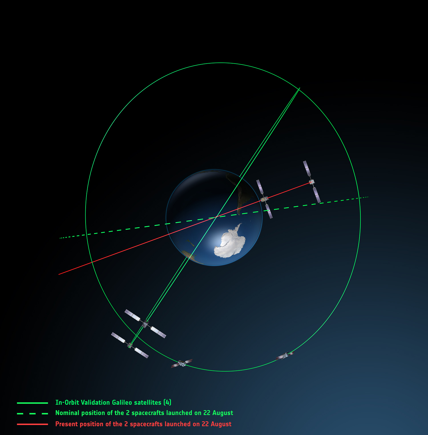
Europe’s fifth and sixth Galileo satellites, salvaged from their faulty 2014 Soyuz launch, will begin broadcasting working navigation signals for test purposes, for the benefit of receiver manufacturers, service providers and scientific researchers. The European Commission will decide later whether the two satellites will become part of the operational Galileo constellation.
The European Space Agency performed a complex series of in-orbit maneuvers to raise and circularize the two after they arrived in space too low and too elliptical for full Galileo use. Their initial orbits dipped the satellites too close to Earth to keep their antennas properly locked on the planet.
“Once their orbits were modified, their navigation payloads could be turned on and in-orbit testing could take place,” explained Marco Falcone, head of the Galileo System Office. “The good news was their performance was excellent.
“The navigation signals will include a signal health status reading that ‘signal component currently in test’ and its navigation data validity status will be ‘working without guarantee.’ In this way, these signals will not disturb the performance of any receivers using the Galileo signals coming from the other satellites. On the user community side, some application providers are interested in harnessing as many available satellites as possible for precision applications.”
Testing will take place in two phases: initially their navigation signal will be updated via the Galileo ground segment every 14 hours or so. Later this year, the ground segment will be reconfigured to send updates more often, enhancing navigation precision, although they will remain outside the official constellation until decided otherwise.
The two satellites are also midway through an ambitious space experiment to test Einstein’s General Theory of Relativity more precisely than ever before, by measuring how their onboard time varies in accordance with their altitude and therefore gravity, known as their gravitational redshift.
New Activation. Galileo GSAT-0210 (PRN E01), one of two launched May 24, began dual-frequency broadcast on Aug. 17, transmitting E1 and E5a signals.
GPS III launch RFP
Competitive bids invited
The U.S. Air Force released a Request for Proposal (RFP) in August for GPS III-3 launch services, scheduled to begin in 2019. The contract will be a standalone for a single GPS III launch.The United Launch Alliance (ULA) and Space Exploration Technologies (SpaceX) are expected to compete for the contract. In April, SpaceX was chosen to launch the GPS III-2 satellite in May 2018. ULA chose not to compete.
The RFP seeks an Evolved Expendable Launch Vehicle (EELV) Launch Service. The Air Force’s acquisition strategy seeks a balance between mission success/operational needs and lowering launch costs, reintroducing competition for national security space missions.
This is the second competitive launch service solicitation under the current procurement strategy. Previously, ULA was the only certified launch provider. In 2013, ULA was awarded a sole-source contract for launch services as part of an Air Force Block Buy of 36 rocket cores. In May 2015, SpaceX was certified for EELV launches, yielding two qualified launch service providers.
M-code, OCX updates
The Air Force awarded a $52.6 million contract to Raytheon for modernization of the Miniature Airborne GPS receiver 2000 (MAGR-2K): test and delivery of an M-code automatic dependent surveillance and broadcast-capable system. Congress has mandated the military buy only M-code GPS equipment by 2018. Last year, Rockwell Collins received a $36.6 million contract for such equipment.
OCX. Raytheon is implementing changes to its GPS Next-Generation Operational Control System (OCX). “Momentum is very good” towards a December 2020 deadline for software delivery, said the program manager. A Pentagon review in July followed breach of a critical cost-growth cap. The complexity of cyber security requirements contributed to delays to date. The company expects to deliver Block 0 software in 2017, in conjunction with plans to launch GPS III satellites. However, the capability will not be turned on until 2018, when an OCX Block 0 launch-and-checkout capability for GPS III launches is to begin.
The Olympics are great for technology. Yes, the competition held every four years highlights amazing athletes. But its vast support network relies on numerous technologies, including GNSS.
GNSS technology helped fans follow the canoe sprint and rowing events in Rio in more detail than before. With GPS devices attached to every vessel, spectators were able to see key data such as speed and direction — information that helps when following a lengthy race taking place offshore.
For the first time, Olympic athletes used high-tech wearables to give them an edge. Solos Smart Eyewear was designed for the USA’s Cycling team with features that allowed cyclists to see key metrics such as speed, power, distance, cadence and heart rate, plus more data from any number of connected sensors.
Drones Aloft. Drone technology has exploded since the London 2012 Olympics. In Rio, broadcasters experimented with hovering cameras. The BBC worked with Open Broadcast Service to provide international broadcasters with drone coverage of the rowing.
As for hobbyists, drone-maker DJI updated its firmware with Olympic geofences, preventing drones from flying over events. Not every drone manufacturer implements geofences, so the Brazilian military was equipped with new devices to jam drone-control signals mid-flight. The IACT DroneBlockers blast incoming drones with radio signals, effectively jamming the signal from the controller.
Beware Zika. Meanwhile, mapping technology is helping to track the spread of the Zika virus. Before the games, the World Health Organization launched a Zika app to provide information about the disease.
After the Olympics, IBM will provide local authorities with ways to track weather, social media data and travel patterns. Esri is supporting local authorities and coordinating field workers to track and contain the disease in Brazil and elsewhere.
Ingrid Daubechies, a prominent mathematician whose pioneering work on wavelets is the foundation for various consumer products and GNSS applications, has received a $1.5 million grant from the Simons Foundation.
Mathematician Ingrid Daubechies, whose pioneering work enabled use of wavelet analysis in a variety of fields, including GNSS. (Image: Duke Today)
Daubechies is the James B. Duke Professor of Mathematics and Electrical and Computer Engineering at Duke University in Durham, North Carolina.
The Math + X Investigator award provides research funds to professors at American and Canadian universities to encourage novel collaborations between mathematicians and researchers in another field of science or engineering.
Wavelets in GNSS. “The mathematical technique of wavelet analysis is being used in several different GNSS applications,” said GPS World’s Innovation columnist Richard Langley. In the October 2003 Innovation article “Wavelet Multiresolution Analysis,” Langley provides a general introduction to wavelet techniques:
“Wavelet analysis is an extension of Fourier analysis, the classical technique that decomposes a signal into its frequency components. However, Fourier analysis cannot determine the exact time at which a particular frequency occurred in the signal.
“Wavelet analysis, on the other hand, allows scientists and engineers to study the frequency structure of time-varying signals with unprecedented time resolution.
“In fact, a signal can be decomposed to obtain a time history of the different frequency bands making up the signal — an approach termed multiresolution analysis. Wavelet analysis can also compress data for more efficient storage and transmission, replacing the original data values with far fewer wavelet transform coefficients.”
Langley explains that to improve GPS accuracy, wavelet analysis is used to “de-noise” GPS pseudorange measurements, detect and eliminate cycle slips in GPS carrier-phase measurements, and separate biases such as multipath from high-frequency receiver noise.
Daubechies and Dinosaurs. “This is a tremendous honor,” Daubechies told Duke Today. She joined Duke’s faculty in 2011. “Thanks to these funds, I will be able to explore new ways to apply ideas from machine learning to adaptive signal analysis and to biological morphology.” For example, she will work with scientists to identify ways to measure fossilized teeth and bones in an effort to map evolutionary changes.
Born in Houthalen, Belgium, Daubechies studied physics at the Vrije Universiteit in Brussels, completing a doctorate in theoretical physics in 1980. She conducted research at AT&T Bell Laboratories in New Jersey before joining Princeton University’s faculty in 1993, eventually becoming the first woman to be a tenured professor in mathematics.
In 2000, she was the first woman to receive the National Academy of Sciences Award in Mathematics. A decade later, she was the first woman elected president of the International Mathematical Union. She is a 1992 MacArthur Fellow, a 2010 Guggenheim Fellow and has been elected into the National Academy of Sciences and the National Academy of Engineering.
NovAtel Inc. has introduced the GPS-713-GGG-N and GPS-713-GGGL-N ATEX-qualified triple-frequency GNSS antennas with an Inmarsat rejection filter.
Based on the company’s pinwheel technology, the antennas offer multi-constellation reception of L1, L2 and L5 GPS; L1, L2 and L3 GLONASS; B1 and B2 BeiDou; as well as E1 and E5 a/b Galileo frequencies.
The GPS-713-GGGL-N also supports L-Band from 1525 to 1560 megahertz. The same antenna can be used for GPS-only, dual or triple constellation applications, resulting in increased flexibility and reduced equipment costs, the company said in a news release.
The phase center of the antennas remain constant as the azimuth and elevation angle of the satellites change. Signal reception is unaffected by the rotation of the antenna or satellite elevation, according to NovAtel. With the phase center in the same location for the GNSS signals, and with minimal phase center variation between antennas, the antenna is suitable for baselines of any length.
The rugged antenna is enclosed in a durable, waterproof housing and meets MIL-STD-810G for vibration, corrosive environment and salt fog, NovAtel says. The GPS-713-GGG-N and GPS-713-GGGL-N are similar in form factor to our other high performance GPS-700 series antennas, and bth antennas meet IEC60945 specifications.
The two antennas deliver choke-ring level antenna performance, but without the size and weight, NovAtel said. Both antennas provide enhanced Inmarsat interference rejection, which allows tracking of GNSS signals in the presence of high-powered Inmarsat transmitters that are typically found on marine vessels.
The workshop aims to enable stakeholders to delve further into their issues in wide area precision clock synchronization in current and future power systems, as well as to collaborate in prioritizing key research and standards activities, NIST says on its website. An NIST report summarizing the challenges of wide area clock synchronization and potential solutions also will be drafted.
In the North American power grid, where each interconnection stretches over a large spatial expanse, achieving correct timing can be challenging, NIST says. Timing needs to include one microsecond synchronization to a traceable time and frequency reference for data fusion. Issues include GPS and communication infrastructure, as well as concerns for reliability and resilience if a reference source becomes unavailable.
The workshop objectives are to clearly identify and analyze the practical challenges that are currently being experienced in wide area time synchronization in current measurement and control deployments, as well as timing-related barriers that prevent the power industry from realizing future measurement and control technologies. Workshop organizers plan to initiate discussion on potential solutions and evaluate the need for standard and metrology enhancements.
Speakers
For a full list of speakers with abstracts, view this PDF.
Aaron Martin and Brett Aguirre, Bonneville Power Administration
Vahid Madani, Ph.D., Pacific Gas & Electric
Anthony Johnson/Brendan Russell, Southern California Edison
Robert Orndorff, Dominion Virginia Power
Glen Chason, EPRI
Sarah Mahmood, DHS
Terry Jones, ORNL
Marc Weiss, Ph.D., NIST Time and Frequency Division
Dhananjay Anand, Ph.D., NIST Software Systems Division
Judah Levine, Ph.D., NIST Time and Frequency Division
Bob Noseworthy, University of New Hampshire Interoperability Lab (IOL)
French Space Agency CNES has signed a cooperation agreement with the company Geoflex, granting it the right to spin off software developed by CNES that employs satellite precise point positioning (PPP) technology.
Under the agreement, CNES is granting Geoflex a license to use its patented technologies in this field with a view to offering a global commercial operational service. This partnership ties in with the agency’s strategy of spinning off its research and development results.
The agreement was signed June 28 at the Toulouse Space Show by Lionel Suchet, CNES’s director of innovation, applications and science, and Romain Legros, chairman of Geoflex.
The Geoflex team was able to draw on more than 10 years’ experience in GNSS precise positioning when they founded their start-up to pursue this project. Through this cooperation agreement with CNES, Geoflex is set to benefit from significant opportunities worldwide in real-time precise positioning, navigation and timing, serving a broad customer base employing applications such as topographic mapping, construction and civil engineering, agriculture, shipping, rail, driverless vehicles and unmanned aerial systems.
“Today’s space technologies will drive revolutionary changes in usage in the future,” Suchet said after signing the agreement. “Through their commitment to developing a global GNSS precise positioning service, CNES and Geoflex are showing that France has a key role to play in innovating and in growing our future economy. The people at this start-up are looking to shake up the status quo, so it was natural that CNES should support them.”
Geneq Inc. has released the SXPad 800H, which the company describes as a feature-packed, rugged handheld GPS data collector at an affordable price.
The SXPad 800H is specifically designed for mobile GIS users in applications ranging from water, electric and gas utilities, transportation, mining, agriculture and forestry.
The high-performance 800-MHz device is designed to give users all the power needed to work with maps and large data sets in the field. It is designed for rugged outdoor use, the company says, with a waterproof seal (IP65) and ability to survive a 5-foot (1.5-meter) drop to concrete. Its 3.7-inch color touchscreen (full VGA) is sharp and is sunlight readable.
Standard features include an extra-long battery life of more than 12 hours on a charge, slots for MicroSD cards and SIM cards, and the Windows Mobile 6.5 operating system.
The SXPad 800H offers features typically seen in more costly mobile devices, the company says, including GSM/GPRS cellular modem, Wi-Fi, Bluetooth, a 5-megapixel camera, and an internal GPS receiver with external GPS antenna port.
The SXPad 800H is optimized for GPS/GIS field data collection using its 1 to 3 meter accuracy internal GPS receiver or one of Geneq’s high-performance SXBlue GPS receivers for sub-meter and centimeter-level accuracy.
Europe’s fifth and sixth Galileo satellites, which were salvaged from their faulty launch into working orbits, are set to begin broadcasting working navigation signals for test purposes.
This activation will allow satnav receiver manufacturers, service providers and scientific researchers to make use of these test signals. A decision on whether these satellites will become part of the operational Galileo constellation is due to be taken by the European Commission
A malfunction in their Soyuz-Fregat upper stage during their Aug. 22, 2014, launch placed Galileos 5 and 6 into highly elliptical — or elongated orbits — instead of their planned circular medium-Earth orbits.
A team based at ESA’s ESOC control centre in Darmstadt, Germany, then performed a complex series of maneuvers to raise and circularize their orbits.
The satellites lacked sufficient fuel to reach their originally envisaged orbits, but the salvage meant that their navigation payloads could then be operated on an ongoing basis; their initial orbits dipped the satellites too close to Earth to keep their antennas properly locked on the planet.
“Once their orbits were modified, their navigation payloads could be turned on and in-orbit testing could take place,” explains Marco Falcone, Head of the Galileo System Office “The good news was their performance was excellent.
“Now they will be tested on a more sustained basis, along with the rest of the Galileo satellites. A pair of ‘Notice Advisory to Galileo Users’ (NAGUs) informing the user community of their availability for testing purposes have been published on the European Global Navigation Satellite System Service Centre website. Users are welcome to provide feedback on their usage of GSAT0201 and GSAT0202 by contacting the GSC helpdesk.
“On our side, switching on their navigation signals allows us to evaluate the entire spectrum of performance of the satellites on an end-to-end basis.
“The navigation signals will include a signal health status reading that ‘signal component currently in test’ and its navigation data validity status will be ‘working without guarantee’. In this way, these signals will not disturb the performance of any receivers using the Galileo signals coming from the other satellites.
“On the user community side, some application providers are interested in harnessing as many available satellites as possible for precision applications.”
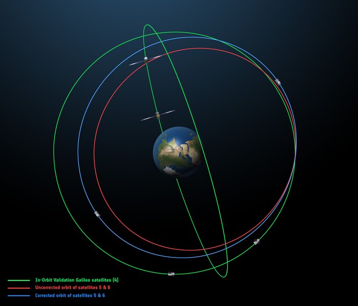
The original (in red) and corrected (in blue) orbits of the fifth and sixth Galileo satellites, along with that of the first four satellites (green).
Because these satellites are not placed in nominal Galileo orbits, the orbital almanacs included in Galileo’s navigation signal will leave out their orbital positions, making Galileos 5 and 6 harder for receivers to locate — although the GSA website will give acquisition details.
Their testing will take place in two phases: initially their navigation signal will be updated via the Galileo ground segment every 14 hours or so. Later on this year, the ground segment will be reconfigured to upgrade the update frequency more often, greatly enhancing their navigation precision — although they will remain outside the official Galileo constellation until decided otherwise.
The two satellites have not been idle since their in-orbit testing was completed. Instead, they are midway through an ambitious space experiment to test Einstein’s General Theory of Relativity more precisely than ever before, by measuring how their onboard time varies in accordance with their altitude and therefore gravity, known as their gravitational redshift.
This experiment uses only the carrier wave of the signals, so will be unaffected by the transmission of navigation messages by satellites 5 and 6.