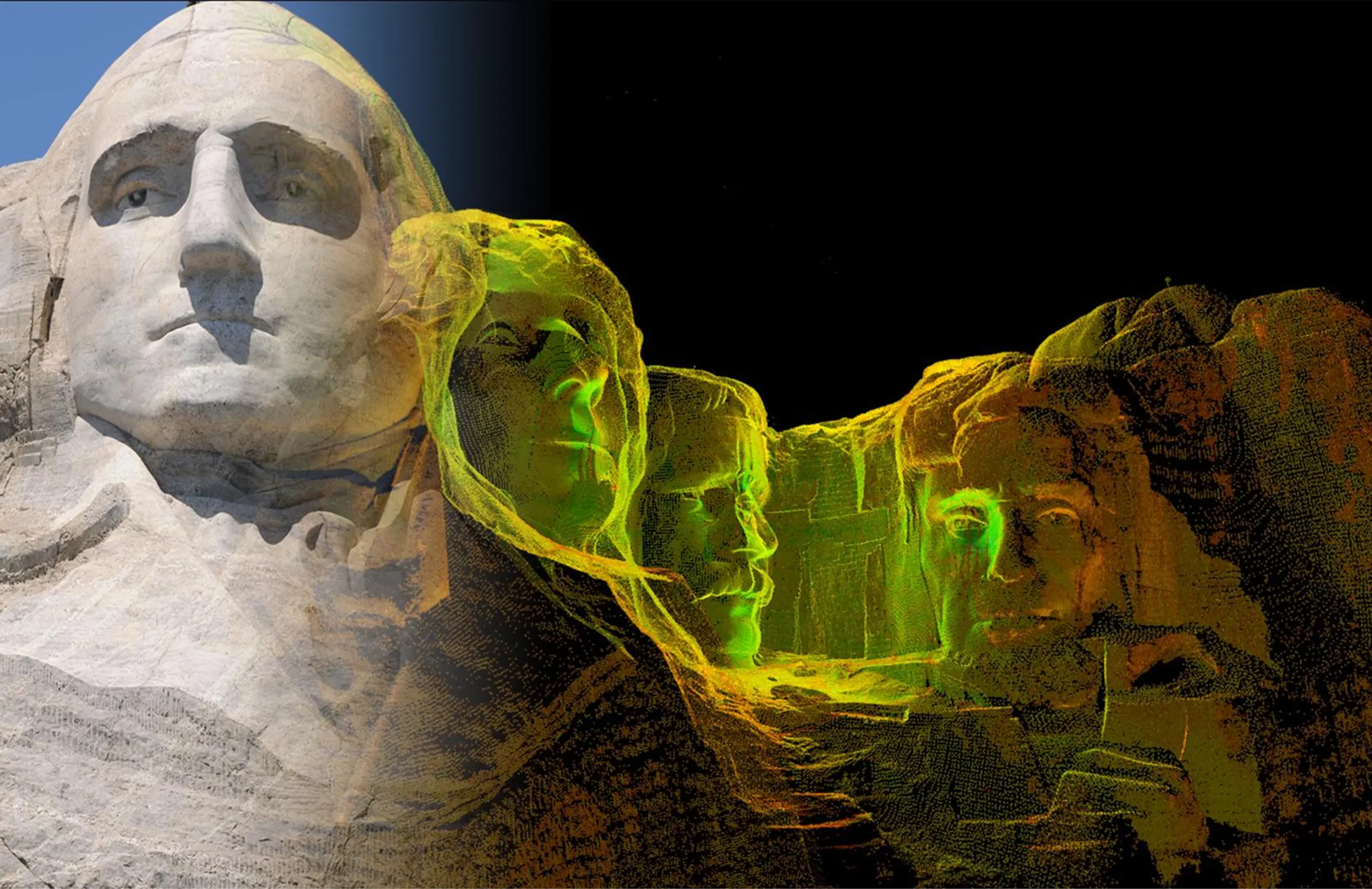
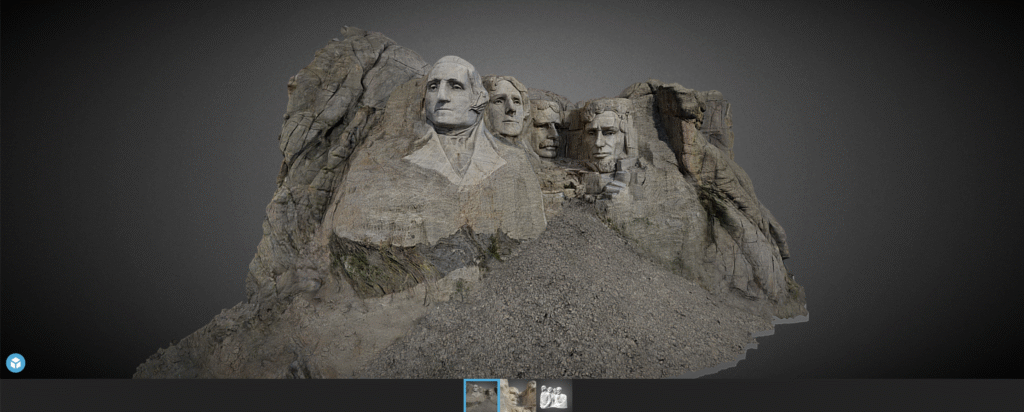
CyArk, a nonprofit organization focused on digital documentation of cultural heritage, has introduced a new virtual experience of the Mount Rushmore National Memorial in the United States. The 15-minute 3D tour — accessible via web, mobile or tablet — offers users an immersive perspective of the monument, highlighting its engineering achievements, artistic significance and the complex cultural narratives associated with the Black Hills region.
The virtual experience allows visitors to virtually ascend to the summit of Mount Rushmore, offering a close-up view of the faces of former presidents George Washington, Thomas Jefferson, Theodore Roosevelt and Abraham Lincoln. From this vantage point, visitors can better understand the intricsye artistry and scale of the carvings, aspects that are not easily observed during an in-person visit. The tour also includes access to the Hall of Records, a chamber situated behind the memorial, and the Sculptor’s Studio, where a 1/12 scale model of the original design — featuring full busts of the presidents — reveals sculptor Gutzon Borglum’s initial vision for the site.
“Mount Rushmore is one of the most recognized memorials in the world, but its story is far more layered than many people realize,” John Ristevski, CEO of CyArk, said in a news release. “We are proud to share this experience in a way that both highlights the engineering and artistry of the site, and acknowledges the deeper histories of the land on which it stands. Our goal is to bring the complexity of this place to light and make it accessible to new audiences.”
Laser scan of Mount Rushmore (Credit: CyArk)
Culture and Collaboration
A key element of the project is the inclusion of multiple voices that offer diverse perspectives on the memorial. Along with the historical context provided by museum professionals, the experience features commentary, music, and dance from Indigenous cultural interpreters who share their personal reflections on the significance of the land commonly known as the Black Hills.
The virtual tour is based on a highly detailed 3D digital twin of Mount Rushmore, created using advanced documentation methods such as terrestrial lidar scanning and high-resolution photogrammetry. The model incorporates data from the 2010 Scottish Ten project — a collaboration between the Scottish Government, the Glasgow School of Art and CyArk — as well as imagery from a 2016 CyArk expedition. These datasets were combined to reconstruct the memorial with millimeter-level precision, capturing both the prominent sculptures and lesser-known features like the Hall of Records and the Sculptor’s Studio. CyArk collaborated with local partners, historians and Indigenous cultural interpreters to shape the narrative and included archival photos from the memorial’s construction.
Silicon Sensing Systems Ltd and Kongsberg Discovery AS have joined forces to develop next-generation inertial technology. The companies signed the formal agreement June 2 during EXPO in Osaka, Japan.
The agreement will merge the engineering skills of both companies to speed the evolution of products within each company. Kongsberg will use developments to enhance their next generation of high-performance systems – including attitude and heading reference systems (AHRS) and inertial navigation systems (INS). Silicon Sensing will use these outcomes to benefit its precision micro electro-mechanical systems (MEMS) inertial measurement units (IMUs), gyros and accelerometers.
The companies are aiming to achieve navigation-grade performance from a MEMS-based gyro. Navigation-grade refers to a highly accurate and stable gyroscope used in inertial navigation systems (INS) to precisely measure angular velocity and rotational motion.
Gyro sensors measure changes in rotation angle over time, enabling detection of direction, angle, and vibration. They are used in smartphones, game consoles, car navigation systems, industrial equipment and devices requiring vibration detection, camera shake correction and attitude control.
“The diverse range of applications for this technology is expected to grow significantly in the future,” said Anders Rønningen, executive vice president, Kongsberg Discovery. “This agreement will foster growth for both companies, as well as for Norway, Japan and the UK. We have established a strong presence in the maritime market and are now venturing into new markets.”
“For over a year we have been working with Kongsberg Discovery, exploring how best to bring our engineering teams together to move us towards performance goals that will extend the capabilities of our entire product portfolio – bringing real operational benefits across many industrial sectors. This important agreement details how we will achieve those ambitions,” said Satoru Miyamoto, general manager, Silicon Sensing (Japan).
David Somerville, General Manager at Silicon Sensing (UK), concludes, “This endeavor will fast-track development activities in key areas for both companies, bringing critical performance gains for customers in fields as diverse as satellite control, subsea mapping, industrial robotics, aviation and maritime.”
What urgent policy or industry actions are needed to protect and advance resilient PNT services amid spectrum sharing debates and GNSS regulation changes?
Jules McNeff, vice president, strategy & programs, Overlook Systems Technologies
In my article, “Is There a Silver Bullet for Resilient PNT?”, I addressed the confusion caused by the numerous and diverse industry initiatives now being offered. Industry is understandably motivated to provide resilient PNT capabilities, but each also wants the government to pick its solution and make policy decisions accordingly. Spectrum sharing decisions that favor a single service provider may harm others in a crowded space, and so are difficult or impractical, as we have seen with the decades of litigation associated with LightSquared/Ligado and the spectrum surrounding the GPS L1 frequency.
Not everyone can win that competition, and as I noted at the end of the article, “Unless our government accepts responsibility, there will be no PNT silver bullet for domestic CI. Experience shows that industry will not solve this problem alone.”
For years, I have advocated that U.S. PNT technology policy be managed and services acquired holistically as vital dual-use civil/military capabilities. For the civilian community, that means making sure the national leadership understands the reliance our domestic critical infrastructure (CI) has on constant access to precise PNT to maintain continuity of operations across all CI sectors in the face of well-known threats. The leadership must then decide whether that reliance deserves proactive attention by the government to ensure PNT continuity is not disrupted.
Several years ago, I suggested that significant regulatory changes were needed in how civil PNT services were handled throughout U.S. CI. Both the Departments of Homeland Security and Transportation were assigned responsibility in Presidential Directives for finding a GPS backup to PNT services in domestic CI. I won’t revisit that years-long debate (which is still unsolved), but I will revive the framework of the suggestion.
The DOT has overall responsibility for civil agency PNT matters, and DHS frequently cites lack of regulatory authority as a limitation on its ability to encourage compliance in the CI sectors for which it is responsible. Therefore, I suggested that the National Space-Based PNT Executive Committee consider regulatory changes to expand the definition of the Transportation CI Sector to include safe and uninterrupted transportation of all elements contributing to domestic critical infrastructure. In addition to current air, road, rail, and oil/gas pipeline transportation, add the interstate transport of information (Communications and IT), electrical energy (Power Grids), economic transactions (Finance), crops (Agriculture), and water, as well as domestic maritime services (U.S. Coast Guard) and possibly emergency response services in the case of large disasters.
In the spirit of the former Interstate Commerce Commission, which years ago was replaced by a DOT Surface Transportation Board (primarily concerned with freight rail), the DOT may then seek expansions to STB authorities and membership to address the PNT dependencies and vulnerabilities affecting those fundamentally transportation-oriented activities vital to the viability of all U.S. critical infrastructure sectors.
— Jules McNeff Overlook Systems Technologies
Miguel Amor, chief marketing officer, Hexagon’s Autonomy & Positioning Division
Regulatory authorities must quickly approve and protect RF spectrum allocated for new PNT capabilities, particularly for emerging low-Earth orbit (LEO) constellations. These systems offer clear advantages in signal strength, geometric diversity and resilience against jamming and spoofing. Without timely and well-defined spectrum authorization, along with strong adjacent-band protections, the deployment of GNSS receivers capable of supporting these constellations will be delayed.
On the industry side, LEO PNT developers must urgently finalize signal structures and release Interface Control Documents, enabling GNSS receiver manufacturers to begin implementation, validation and system integration.
— Miguel Amor Hexagon Positioning Intelligence
Mitch Narins, Strategic Synergies
Interesting and timely question. I’ve written quite a few pieces and papers on the need for resilient and robust PNT services. If I were to point to a single thing that has held the US (and many other countries in the world back (except for China) it is lack of strong mission-oriented, dedicated leadership. It has been said that the definition of a committee is an entity with four or more legs and no brain. It is time to designate a single entity and a single office and a single person as responsible for ensuring resilient PNT services to US critical infrastructure so as to maintain the safety and security and economic benefits these these sectors support. Some wise men once came up with the idea that a government must “provide for the common defense” and “support the general welfare.” Resilient PNT is essential to achieving both.
In addition to the lack of empowered, centralized PNT leadership, a key problem that has impeded progress towards resilient PNT is the lingering belief by many that given enough time and money and spectrum, GNSS-sole means is achievable and that all non-GNSS systems (affectionately called “Legacy PNT Systems”) can be discontinued. In fact, over the years budget justifications for GNSS systems have used discontinuance of ground-based systems as “a benefit” to balance out the costs of establishing, updating, and operating GNSS.
Engineering System Designer should never fall in love with their solutions. The mission, i.e., the needs of the customers must always remain their first concern. After many years, integrity was added to the list of PNT metrics; coverage has yet to be officially added. Yet, even today, there remains confusion regarding the availability metric and the associated risks. For GNSS systems, the risk of losing required PNT metrics should always be considered “1.0”, and therefore, for critical infrastructure users and providers, require effective and implementable contingency/continuity of operation plans. Loss of PNT performance (accuracy, availability, integrity, continuity, and coverage) the using GNSS can no longer be considered a “Black Swan” event.
— Mitch Narins Strategic Synergies
In the February 2025, Professor Washington Ochieng proposed the following question to the GPS World EAB.
When we discuss the security of GNSS/PNT systems, we nearly always focus on interference — i.e., meaconing, intrusion, jamming or spoofing. However, GNSS/PNT systems are embedded in systems of systems that also offer many other opportunities for cyberattacks. What should we do about it?
I have thought for some time about why this is an issue. This is an interesting question, and the answer should be straightforward – but it’s not. For whatever reason, it seems many in the “cyber community” believe they are different, somehow, and apart. This has been apparent to me in dealing with those in the cyber community regarding their PNT dependencies and vulnerabilities going back to the creation of USCYBERCOM as a separate combatant command within the DoD. Those in the cyber world seemingly do not see a need to recognize and account for the intersection of PNT and cyber as mutually integral parts of a broader Information Technology ecosystem. Yet, across that entire IT ecosystem, PNT is simultaneously an enabler and a product of IT functionality, as communications and data systems could not operate without it, and it is likewise vital to IT users in executing their diverse missions. Ultimately, interference effects, whether from jamming or spoofing in their various forms or from digital intrusions of one kind or another, disrupt vital elements of that IT ecosystem. Our national and economic security depend on the continuous, reliable, uncorrupted functioning of IT services enabled by and delivering PNT information. So, a straightforward but difficult to implement answer is that we need formal education programs to routinely inform the leaders of industry and government (and the public) of the ubiquitous, vital role of positioning and timing (what we call PNT) throughout all the systems-of-systems whose operation depends on the IT ecosystem – and how to tell if something is amiss.
A link to the live event will be sent to you two hours before the event. Your personalized event URL will be automatically generated by the ON24 system. To ensure receipt of the email, please whitelist this email address by adding it to your contacts: [email protected].
This presentation will begin at 1 p.m. EDT on Thursday, June 26. A recording will also be sent to you the following day so you can watch it on-demand.
Audience members may arrive 15 minutes prior to live time. If you have any questions, please contact event producer Halle Reid at [email protected].
Question: What are the main challenges facing GNSS/GPS-based autonomous solutions in terms of signal integrity, jamming and spoofing, and how are these being addressed?
Answer: Outside of the military, interference is the most common threat to GNSS, with the dominant source being cellular transmission harmonics. It is commonly addressed with out-of-band filters. Non-terrestrial networks (NTN), like Global Star uplink at 1.6 GHz, are gaining traction in more mobile and wearable devices to fill gaps in cellular availability. However, it can create coexistence issues for devices for concurrent L1 GNSS reception during NTN uplink.
In military cases, while intentional interference is effective, the increasing number of GNSS bands to cover requires more transmission power. Modernized GNSS signals with wider bandwidth signals require more jamming power, which risks detection by radiofrequency emission satellite systems such as Hawkeye 360. The frequency of spoofing events will likely continue to increase and spill over into civilian domains.
Thanks to the increasing number of test ranges being made available to commercial GNSS developers, anti-spoofing technology is making some gains, at least in the high-end systems used for autonomous GNSS.
Q: What are the most impactful use cases and sectors benefiting from recent advancements in autonomous solutions?
A: Ride sharing and transport are the likely winners in exploiting the cost savings of driverless systems with autonomous navigation. The past 15 years’ investments in the development of augmented navigation systems — mainly lidar and vision-based — are finally paying off as we see Waymo in service, and soon Uber and Tesla in commercial deployments. Still, these systems depend solely on GNSS as the absolute positioning system, used for navigation in non-urban environments, but also fallback in certain cases where the sensors are problematic, as well as system calibration.
Agriculture, being one of the first segments to exploit autonomous solutions, can still see incremental gains as GNSS corrections systems move RTK from local to regional, allowing some monthly service margin improvements. High-precision consumer products like robotic lawn mowers will be enabled with similar infrastructure. Data services are a key part of infrastructure, for communication as well as precision navigation enablement. Companies such as Swift Navigation, Point One Navigation and RxN networks are expanding their networks and competing with the likes of Trimble and Hexagon.
We are pleased to announce that Paul McBurney, Ph.D., has agreed to join GPS World’s Editorial Advisory Board. He is currently CTO and co-founder of OneNav. Prior to that, McBurney was a GNSS architect at Apple. He was co-founder and CTO of eRide, a fabless semiconductor company specializing in high sensitivity GPS and sensor fusion that Furuno acquired in 2009. He also worked for nearly 10 years at Trimble Navigation, as well as Stanford Telecommunications. He received his Ph.D. in Electrical Engineering from Iowa State University in 1988 with a focus on GPS integrity monitoring. He has more than 50 patents in the areas of GPS, AGPS and sensor fusion.
Could new clocks protect planes from spoofing of GNSS signals?
GNSS receiver builders would certainly take advantage of better oscillators. Poor clocks hurt performance, while stable clocks improve performance and provide a source of reliable information. A better oscillator by itself cannot prevent getting spoofed, but it can be an important component of an anti-spoofing regime not only for detection but also for mitigation. At OneNav, we started testing SiTime MEMs oscillators. We are using some SiTime devices that have nearly perfect reference frequency, with less than 100 ppb and amazing shock and temperature stability. They are not cheap, but they are improving the manufacturability for lower cost.
TV broadcasters have petitioned the Federal Communications Commission for permission to provide PNT signals.
In the 1990s, Rosum Corp. of Redwood City, California, first tried to do positioning using TV signals. They were famous for a while and most of their engineers are in GNSS now. The inherent advantages of the multipath mitigation in the signal structure are still unexploited, mainly because TV tower navigation suffers from poor positional dilution of precision as many towers are on the same hilltop. It’s hard to imagine what changed in the manufacturing or business model to put this in the news again. It seems like a tough problem to adopt the silicon in a cell phone to receive this signal. It won’t be an answer for resilience except domestically.
Some claim that quantum systems could transform navigation.
Even navigation-grade IMUs have relatively short viability with meter-level accuracy without GNSS. We are preparing some jamming and spoofing tests with the U.S. Navy’s Stiletto program. The IMU is the limit of the project, and quantum IMUs would make a huge impact.
The Federal Aviation Administration is moving toward approving the use of controlled reception pattern antennas (CRPAs) on aircraft.
This is great news for everyone. It will herald a new movement toward more production, with lower cost and improved performance. We need this technology in everything that moves the public.
On February 24, the sun unleashed an X-class flare, triggering a radio blackout across the Pacific Ocean.
Once again, it’s centered on the equator, where most of the heavy stuff with the ionosphere happens. Research on geomagnetic equatorial ionosphere is on the frontier of ionospheric research. Events like this are wild points that don’t make it into the 3 sigma events. Single frequency receivers that rely on total electron content models for accuracy usually see some impact from these solar storms. The ionosphere has a subtle impact on people all over the world. Did anyone notice their navigation system acting any stranger than usual? Did anyone lose any money on the stock market because the timing accuracy degraded from 5 ns to 20 ns? Did a self-driving car have a blackout? I doubt it. But it’s an important part of a data sheet. Companies such as Novatel and Trimble should comment on how they did.
GPS World is celebrating its 35th birthday in 2025 by welcoming back longtime editor Tracy Cozzens as Editor-at-Large.
A subsidiary of Cleveland-based North Coast Media, GPS World is a business-to-business media brand covering GPS, GNSS and Complementary positioning, navigation and timing solutions and trends.
“Serving this highly technical market for 20 years, I have been privileged to build wonderful relationships with many technology innovators,” Cozzens said. “I simply couldn’t stay away from what I know — GPS, GNSS and PNT — and whom I know. There’s nothing like our industry when it comes to non-stop technology breakthroughs that broadly advance our world.”
Cozzens returns to bring her deep industry insight and editorial leadership at a time when rapid innovation is reshaping GNSS/PNT landscapes.
“As a 35th birthday gift to our loyal family of GPS World marketing partners, and unmatched audience of readers — qualified/audited GPS/GNSS/PNT buyers and specifiers — we wooed Tracy Cozzens out of retirement,” said GPS World Sales Director Tod McCloskey. “Tracy’s award-winning gumshoe reporting and stellar content-creation skills for decades have helped keep industry leaders informed on GPS, GNSS and PNT technology trends. Now, Tracy also will help shape the content calendars for GPS World’s market-leading magazine, website, e-newsletters and social media.”
Cozzens will report directly to GPS World Editor Diane Sofranec.
“Seen & Heard” is a monthly feature of GPS World magazine, traveling the world to capture interesting and unusual news stories involving the GNSS/PNT industry.
Amazon sued for alleged privacy violations
Photo: Hispanolistic / E+ / Getty Images
Amazon is facing a lawsuit in Washington state, marking the first dispute under the state’s My Health My Data Act. The lawsuit accuses Amazon of violating privacy laws by collecting location data from millions of Americans without their consent through its software development kits used in various mobile applications. The collected data allegedly included information that could indicate a consumer’s attempt to acquire health services, violating the My Health My Data Act, which requires explicit consent for collecting and selling health-related data.
Europe’s first lunar lander underway
Photo: ESA
The European Space Agency (ESA) has partnered with Thales Alenia Space to develop Argonaut, Europe’s first lunar lander. This spacecraft will provide autonomous access to the Moon, supporting international exploration efforts. Starting in the early 2030s, Argonaut will conduct regular lunar missions, delivering infrastructure, scientific instruments, rovers and essential resources for astronauts. Designed to withstand harsh lunar conditions for up to five years, Argonaut will play a crucial role in sustainable lunar exploration, according to ESA.
Leica Geosystems, SCI-Arc equip future architects
Photo: Leica Geosystems
Leica Geosystems and the Southern California Institute of Architecture (SCI-Arc) have partnered to equip future architects with advanced technology skills. Leica is donating more than $200,000 in equipment, including lidar scanners, and offering expert guidance and scholarships to students. SCI-Arc students are applying this technology to create digital archives of Los Angeles structures and visualize rewilded wilderness.
In a recent study published by Nature Communications, researchers share that GNSS spoofing in conflict zones is disrupting wildlife tracking efforts, particularly affecting black-tailed godwits migrating through Eastern Europe. Researchers tagged 15 godwits in Finland in May 2024. Eight of these birds displayed spoofed geolocations during their migrations. The most significant spoofing occurred near Simferopol airport in Crimea, where birds were falsely located while flying over Ukraine or Romania. This spoofing added substantial errors to migration tracks, in one case creating a false 7,200-km round trip.
When we discuss the security of GNSS/PNT systems, we nearly always focus on interference — i.e., meaconing, intrusion, jamming or spoofing. However, GNSS/PNT systems are embedded in systems of systems that also offer many other opportunities for cyberattacks.
What should we do about it?
Ellen Hall
“The key is platform architecture, specifically ensuring robust spatial and temporal partitioning between safety-critical and non-safety-critical functions. Safety-critical functions, such as navigation and autopilot, must be isolated from non-safety-critical functions, such as mission compute, where artificial intelligence typically operates. This partitioning minimizes the scope and effort required to produce design assurance artifacts for airworthiness certification. Additionally, it enhances security by reducing potential attack vectors through the isolation of safety-critical and mission-critical capabilities.”
— Ellen Hall Imminent Federal
Mitch Narins
“An old mariner’s proverb is: ‘The prudent mariner never relies solely on any single aid to navigation.’ A more recent statement offers: ‘With so many pieces of sophisticated electronic equipment at our beck and call it would seem some are lulled into complacency and are ignoring basic seamanship.’ In September 2018, the U.S. Naval Institute published an article titled, ‘Professional Mariners Cannot Rely on Electronics Alone.’ The recent news that the U.S. ITAR restrictions on multi-element antenna arrays will be lifted (thanks to many in our community who have lobbied hard for this for many, many years) is excellent news. It will help and was a necessary change — but it is not sufficient. It certainly does not remove the need to pursue complementary, PNT solutions that will ensure the safety, security, and economic well-being of PNT users and their PNT-dependent systems worldwide. From a basic systems engineering perspective, incorporating multiple solutions with independent failure mechanisms is ultimately the end product that we in the PNT community should all be seeking. We must not forget, however, a key element of many of these systems: the human in the loop, who, if continually provided the opportunity to train in PNT-challenged environments, often can be the ultimate system safety element. This will require the design of our PNT services to ensure that the human factors designed into these systems include sufficient information for the human component to understand an off-normal situation and have the training and skills to take the appropriate corrective actions.”
A link to the live event will be sent to you two hours before the event. Your personalized event URL will be automatically generated by the ON24 system. To ensure receipt of the email, please whitelist this email address by adding it to your contacts: [email protected].
This presentation will begin at 1 p.m. EDT on Thursday, March 13. A recording will also be sent to you the following day so you can watch it on-demand.
Audience members may arrive 15 minutes prior to live time. If you have any questions, please contact event producer Halle Reid at [email protected].
A link to the live event will be sent to you two hours before the event. Your personalized event URL will be automatically generated by the ON24 system. To ensure receipt of the email, please whitelist this email address by adding it to your contacts: [email protected].
This presentation will begin at 1 p.m. EST on Thursday, February 20. A recording will also be sent to you the following day so you can watch it on-demand.
Audience members may arrive 15 minutes prior to live time. If you have any questions, please contact event producer Halle Reid at [email protected].
A link to the live event will be sent to you two hours before the event. Your personalized event URL will be automatically generated by the ON24 system. To ensure receipt of the email, please whitelist this email address by adding it to your contacts: [email protected].
This presentation will begin at 1 p.m. EST on Thursday, December 5. A recording will also be sent to you the following day so you can watch it on-demand.
Audience members may arrive 15 minutes prior to live time. If you have any questions, please contact event producer Jesse Khalil at [email protected].