North Coast Media (NCM) is proud to announce the addition of four seasoned media professionals to the GPS World team.
On the business side, Brian Kanaba has been appointed as Publisher and Tim Carolin as Account Executive. On the content side, Brian Richesson joins as Senior Editor in Chief and Joey Ciccolini as Senior Digital Media Specialist. All four will work closely with current Editor-in-Chief Matteo Luccio and Associate Editor Jesse Khalil.
“GPS World has been the industry’s most-trusted GNSS/PNT resource since 1990,” said Kevin Stoltman, President and CEO of NCM. “We are thrilled to have more resources dedicated to our market-leading GPS World brand. We will continue to create products designed to serve our readers and marketing partners, maximizing their growth for years to come.”
Richesson brings more than 17 years of business-to-business media experience, currently also serving as Editor in Chief of NCM’s sister publication, LP Gas magazine. Prior to his business media career, he spent about 10 years in the newspaper industry. Ciccolini brings five years of experience in the digital media realm, including with video, webinars and e-newsletters.
“Joey and I look forward to collaborating with Matteo and Jesse,” said Richesson. “Their reporting on new technologies and applications for GNSS receivers, antennas, simulators, and alternative PNT solutions has been exceptional. We’ll lean on their knowledge about this exciting industry as we get to know the companies and the individual leaders doing great work in this space.”
Kanaba, with over 20 years of media management and sales experience, will spearhead the business side of GPS World. He will work closely with Carolin, who brings about seven years of experience as a media account executive, to deliver the most comprehensive mix of products and innovative solutions designed to stimulate growth for its marketing partners.
GPS World, part of the North Coast Media conglomerate based in Cleveland, Ohio, has covered the business and technology of global positioning, navigation, and timing (PNT) since 1990. GPS World remains the multi-platform media leader, delivering the freshest and most comprehensive GNSS-related news to high-level corporate managers, project and engineering managers, product designers, researchers, and system developers — all of whom rely on GPS World for making critical purchase decisions in this multi-billion dollar market.
Photo:
Click here for more information on North Coast Media.
A link to the live event will be sent to you two hours before the event. Your personalized event URL will be automatically generated by the ON24 system. To ensure receipt of the email, please whitelist this email address by adding it to your contacts: [email protected].
This presentation will begin at 1 p.m. EDT / 10 a.m. PDT on Thursday, March 14. A recording will also be sent to you the following day so you can watch it on-demand.
Audience members may arrive 15 minutes prior to live time. If you have any questions, please contact event producer Jesse Khalil at [email protected].
“Seen & Heard” is a monthly feature of GPS World magazine, traveling the world to capture interesting and unusual news stories involving the GNSS/PNT industry.
According to Guinness World Records, a 982.53-mile, seven-day ride by David Schweikert was the “largest GPS drawing by bicycle”. His drawing of a cross spanned three U.S. states: Wisconsin, Nebraska and South Dakota. “GPS drawings,” or Strava art, are growing in popularity, with two other notable record attempts being made in the past 12 months. Schweikert completed his ride in May, but for Guinness World Records to consider a record official all documentation and data must be verified. There are also strict rules and regulations relating to mileage that deviates from the course. To stick strictly to the profile of the cross, Schweikert rode 35% of his trip on unpaved roads.
The Connecticut State Police is under fire for failing to archive vehicle location data. While all police cruisers are equipped with location technology, only live data is available, reported CT Insider. Officials can locate a police cruiser when the vehicle is in use but cannot determine where it has been in the past. Experts and lawmakers told CT Insider that not archiving location data for some period of time is unusual, and they are worried that it could make it harder to hold troopers accountable when their conduct comes into question — including in multiple ongoing investigations examining allegations of ticket falsification within the force.
The Saving Wildcats conservation project, based at Cairngorms National Park in the Scottish Highlands, is using tracking collars to study endangered wildcats. For the project, 19 wildcats were released into the park while a field research team monitored movement data and was alerted if any of the animals were hurt or killed. This project is a collaboration between the Royal Zoological Society of Scotland (RZSS), NatureScot, Forestry and Land Scotland, and the Cairngorms National Park Authority. The new kittens, born at RZSS’s Highland Wildlife Park, will be released into the wild next summer once they are aged six to eight months.
Photo: Croydon High School
High School Launches Weather Balloons
Croydon High School, in partnership with the University of Bath, has completed the Astrogazers project, which involved launching a weather balloon into space. On September 12, a team of girls from grades 5 through 11 successfully launched two meteorological balloons that ventured to an altitude of 32,380 m. The balloons carried essential equipment, including cameras, data loggers and GNSS receivers — all designed to explore how different materials respond to atmospheric conditions.
GNSS researchers presented hundreds of papers at the 2023 Institute of Navigation (ION) GNSS+ conference, which took place Sept. 11-15, 2023, in Denver, Colorado, and virtually. The following four papers focused on the use of precise-point positioning for various applications. The papers are available here.
Smartphone Positioning Resiliency
Ultra-low-cost GNSS receivers used in smartphones have several drawbacks that include insufficient observations and poor signal reception quality compared to higher-cost receivers. The authors of this article proposed that using native sensors and precise-point positioning (PPP) augmentation can offer resilient smartphone positioning.
During their research, the authors deployed only inertial measurement unit (IMU) and GNSS sensors native to existing smartphones. They were able to achieve a standalone solution using PPP and IMU integration that performed better than standard techniques.
In vehicle experiments with unobstructed sky, the sensor integration algorithm achieved 1.6 m horizontal RMS. This reduced 80% of horizontal errors in GNSS-challenged environments through a tightly coupled GNSS-PPP solution that has not appeared in any other publications according to the authors.
To address resilient smartphone positioning, the authors stated that sensor fusion is also being explored by using smartphone sensors, including IMUs, cameras, and other fusion techniques.
Yang, Yi, Vana, and Bisnath, “Resilient Smartphone Positioning Using Native Sensors and PPP Augmentation.”
Multi-GNSS PPP and MEMS IMU Integration for Navigation in Urban Environments
This paper addressed the issue of accurate, precise and continuous navigation in obstructed environments for vehicles. To provide a low-cost lane-level navigation solution for automotive applications, the authors proposed an integrated solution featuring low-cost GNSS PPP and MEMS-based IMUs.
During the authors’ research, they introduced a low-cost, triple-frequency GNSS, a MEMS-based IMU and a patch antenna to achieve decimeter-level accuracy in suburban and urban environments. Low-cost hardware and software were used to bridge GNSS gaps in urban environments to provide a continuous, accurate, and reliable position solution that is novel and has not been previously published, according to the authors.
The low-cost navigation system demonstrated an accuracy of less than a decimeter in the presence of a sufficient number of satellites. During half a minute of introduced GNSS signal loss, the overall RMS of the algorithm was 10% to 40% better than dual-frequency PPP with IMU as the satellite availability was reduced.
The results obtained during partial GNSS availability indicated a step forward in the low-cost navigation area for applications such as low-cost autonomous vehicles, intelligent transportation systems, and more that demand a decimeter level of accuracy.
Vana and Bisnath, “Low-Cost, Triple-Frequency, Multi-GNSS PPP and MEMS IMU Integration for Continuous Navigation in Simulated Urban Environments.”
Message Authentication for PPP/PPP-RTK Data
This paper analyzed candidate schemes for PPP/PPP-real-time kinematic (RTK) data authentication. As current PPP/PPP-RTK services are not authenticated, the motivations behind the authors’ research were the new availability of GNSS authentication services such as the Galileo Open Service Navigation Message Authentication (OSNMA), new PPP/PPP-RTK services such as QZSS Centimeter Level Augmentation Service (CLAS) and Galileo High Accuracy Service (HAS), and more.
In this paper, asymmetric schemes were proposed based on existing standards and compatibility with GNSS messages. Post-quantum cryptographic signatures were also reviewed and discussed. Two of the schemes were selected for analysis: digital signature based on ECDSA, and delayed disclosure based on a hybrid scheme using the TESLA protocol.
Each of the schemes was described in detail for both Galileo HAS and QZSS CLAS. The performance of the schemes in terms of time to receive the corrections message and the increase in the age of the data was analyzed. The analysis was complemented by a review of the CPU consumption at receiver level.
Fernandez-Hernandez, Hirokawa, Rijmen, and Aikawa, “PPP/PPP-RTK Message Authentication.”
Creating Consistent RVIM By Estimating Receiver Biases
Ionospheric augmentation is one of the most important dependences of PPP-RTK. Due to the dispersive features of the ionosphere, the ionospheric information is usually coupled with satellite- and receiver-related biases. This could result in inconsistent ionospheric corrections if a different number of reference stations are involved in the calculation.
In this paper, the authors aimed to introduce a consistent regional vertical ionospheric model (RVIM) by estimating receiver biases. First, they presented the inconsistent ionospheric corrections under sparse networks. Then the RVIM was compared with the International GNSS Service (IGS) final global ionospheric map (GIM) product, and the average of differences between them is 1.13 TECU.
The slant ionospheric corrections were then employed as a reference to evaluate both RVIM and GIM. The RMS values were 1.48 and 2.23 TECU for the RVIM and GIM. Finally, the authors applied the RVIM into PPP-RTK.
The results showed that the PPP-RTK with RVIM constraints improved horizontal errors, vertical errors, and convergence time by 43.45%, 29.3%, and 22.6% under the 68% confidence level, compared with conventional PPP-AR.
Lyu, Xiang, Tang, Pei, Yu, and Truong, “A Consistent Regional Vertical Ionospheric Model and Application in PPP-RTK Under Sparse Networks.”
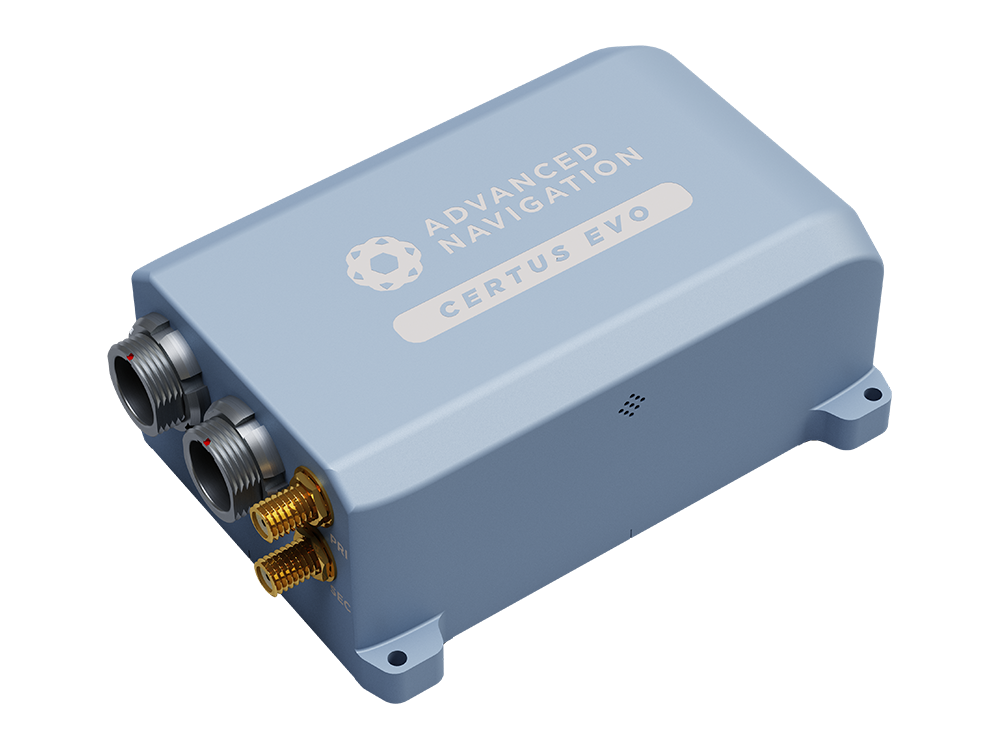
For demanding applications where precise navigation really matters and where size, weight and power are at a premium, Certus Evo exceeds the accuracy of many fibre optic gyroscopes while providing a very compact, lightweight and low power solution. This makes it ideal for applications such as aerial surveys where high performance is required and where flight times can be extended by minimising component weight and power consumption. The AI-based fusion algorithm takes full advantage of high-accuracy MEMS accelerometers and gyroscopes to deliver dependable performance at an affordable price point. Integration or customisation is made easy with extensive connectivity options and access to world-class technical support.
Low-power anti-interference (LAI) technology is ComNav’s patented advanced technology to counter, narrowband and continuous-wave interference. The SNR can reach 60 dB and the power consumption is only 0.1 W when enabled.
LAI technology can quickly detect and mitigate interference through simple setup to ensure the safety of equipment during operation.
In latest firmware version, K8-series receivers have added advanced interference detection and suppression features, which can detect and suppress radio interference sources. ComNav has also added technology that can output interference source spectrum data, which can be used to detect interference types and possible interference sources.
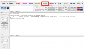
2. Spectrum function in MyPort software
Clients can use ComNav MyPort software to detect and mitigate interference.
To do this, open MyPort, select Spectrum in the software, check the scan frequency and scan range, and adjust the scan frequency manually.
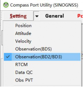
Then select Observation (BD2/BD3) in Setting.
Users can set the scanning frequency and range in Frequency Spectrum Setting.
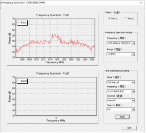
To set anti-interference, users can select the mode as needed.
When CWI Manual is not selected, the frequency, channel and switch are not selectable. When CWI Manual is selected, users can manually configure the frequency, channel and switch.
3. Example
Here is an example that shows all these steps.
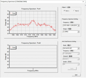
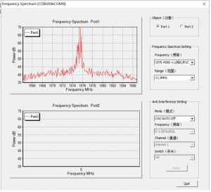
We added 60 dBm interference at 1.57542 GHz (GPS L1) using an RF signal generator as interference.
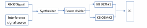
The device is connected as shown in the figure below. The satellite signal and the interference signal provided by the RF signal generator are sent to the module to be tested by the confluence. The signal-to-noise ratio and positioning status are concerned.
Note that the default scan number is 200.
Spectrum diagram when only the GNSS signal is connected.Spectrum diagram when adding an interference signal source.Spectrum diagram after activating anti-interference.
4. Data analysis
If the user needs data further analyzed, it can be decoded using the Binary_MsgDecode tool. A column of data can be obtained by decoding, and the data can be imported into Excel for plotting. The horizontal coordinate is the scanning frequency, which can be obtained according to the scanning frequency and scanning range of the central point set by the user. The ordinate is the interference intensity, which can be obtained by the formula dBm=20log(A) (A is the scan value).
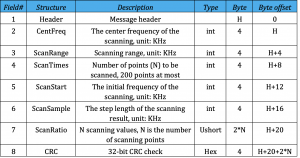
This command is used to set spectrum scanning parameters.
Parameter:
center-freq: Set the scanning center frequency, unit: KHz
scan-range: Set the scanning range, unit: KHz
scan-times: Set the number or the scan points
mode: L1/L2/L5, according to the center frequency of L1, L2, L5 frequency points, the scanning range is 8000KHz, 200 points scanning.
Example:
SCANSPECTRUM 1575420 8000 200
Message:
Message structure:
4.1 Data playback
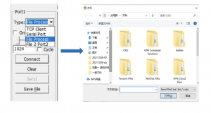
MyPort software supports data playback function. Users can play back the saved data according to their needs.
To do this, disconnect the connection, select File Process, then click Connect, and the folder will automatically appear; users can choose the appropriate sub-folder from there.
4.2 Data decode
Open Binary_MsgDecode software, drag the file in, then click Enter and it will auto decode a file named Message2264.log, which the client can use for further analysis.
The same 91 signers also sent an identical letter to President Biden.
April 24, 2023
Dear Senators and Members of Congress:
Last year, many of the undersigned wrote in reflection of the unprecedented opposition to the Federal Communications Commission’s (FCC’s) Ligado Order(1) across the vast federal and commercial user base of Global Positioning System (GPS), satellite communications and weather forecasting services. Three years after adoption of the Order, as eight petitions for reconsideration remain pending, (2) we again urge you to work together with the FCC to stay and ultimately set aside the Order. (3) Critically, this is now necessitated by the crucial, previously unavailable information that was produced at the direction of Congress: the independent technical review undertaken by the National Academies of Sciences, Engineering, and Medicine (NAS) (4) analyzing the potential interference issues related to the Ligado Order.
We greatly appreciate your administration’s opposition to the Ligado Order and commitment that the National Telecommunications and Information Administration (NTIA), on behalf of the executive branch, will continue to actively pursue its petition for reconsideration of the Order. (5) As you know, the pending petitions for reconsideration convincingly demonstrate that the Ligado Order is legally and factually deficient. In the pending petitions, parties showed that the Ligado Order is fundamentally flawed, incompatible with the FCC’s rules and inadequate in protecting incumbent services from the harmful interference from Ligado’s proposed operations. This substantial documentation, among many other concerns from federal and commercial users, resulted in Congress enacting bipartisan legislation in consecutive years after the FCC’s adoption of the Ligado Order, mandating NAS’s independent technical review and requiring the Department of Defense (DoD) to brief federal representatives across the government “at the highest level of classification” on the potential for widespread harm from Ligado’s proposed terrestrial operations. (6) On this basis alone, the FCC should stay the Order in an acknowledgement that it clearly did not account for the full, real-world risk of harm associated with a nationwide terrestrial deployment in the L-band.
While the pending petitions have a strong likelihood of success on their own merits, the FCC’s rules and the public interest now require the FCC to reconsider the Order in response to the extensive analysis in the NAS Report. (7) This new, previously unavailable information presented in the Congressionally-mandated independent technical review confirms that Ligado’s proposed terrestrial operations would cause harmful interference (8) at significant ranges to incumbent L-band services across a broad range of deployment scenarios. This is consistent with the well-supported and robustly documented analyses and determinations of the federal government, (9) including fourteen federal agencies and departments, (10) and commercial parties (11) alike. Importantly, as concisely stated by DoD and detailed in the NAS Report, “[t]he terrestrial network authorized by [the Ligado Order] will create unacceptable harmful interference for DoD missions. The mitigation techniques and other regulatory provision [sic] in [the Ligado Order] are insufficient to protect national security missions.”(12)
The unequivocal conclusions of the NAS Report constitute the exact type of previously unavailable information that the FCC’s rules (13) dictate must be addressed on reconsideration. Indeed, NTIA stated on behalf of the executive branch that the NAS Report “offers the [FCC] an important opportunity to reconsider Ligado’s Authorization.”(14) We therefore urge you to work with the FCC to address the harm from Ligado’s proposed terrestrial network to critical GPS, satellite communications, and weather forecasting services by staying the Order, addressing the previously unavailable information contained in the NAS Report, and resolving the pending petitions for reconsideration.
Sincerely,
AccuWeather, Inc.
Aerospace Industries Association
Agricultural Retailers Association
Airborne Public Safety Association
Aircraft Electronics Association
Aircraft Owners and Pilots Association
Airlines for America
Alabama Agricultural Aviation Association
ALERT Users Group
Allied Pilots Association
Air Line Pilots Association, International
American Geophysical Union
American Meteorological Society
American Rental Association
American Road & Transportation Builders Association
American Weather and Climate Industry Association
Arizona Agricultural Aviation Association
Arkansas Agricultural Aviation Association
Associated Equipment Distributors
Association for Uncrewed Vehicle Systems International
(1) Ligado Amendment to License Modification Applications, IBFS File Nos. SES-MOD-20151231-00981, SAT-MOD-20151231-00090, and SAT-MOD-20151231-00091, Order and Authorization, 35 FCC Rcd 3772 (2020) (“Ligado Order” or “Order”).
(2) More than twenty parties in total signed petitions for reconsideration of the Ligado Order and all of these petitions remain pending before the FCC. See Petitions for Reconsideration of the National Telecommunications and Information Administration; the Air Line Pilots Association, International; the American Road & Transportation Builders Association, the American Farm Bureau Federation, and the Association of Equipment Manufacturers; the Joint Aviation Petitioners; Iridium Communications Inc., Flyht Aerospace Solutions Ltd., Aireon LLC, and Skytrac Systems Ltd.; Lockheed Martin Corporation; Trimble Inc.; and the Resilient Navigation and Timing Foundation, IB Docket Nos. 11-109 & 12-340 (all filed on or about May 22, 2020). The ten “Joint Aviation Petitioners” consist of the Aerospace Industries Association, the Aircraft Owners and Pilots Association, Airlines for America, Aviation Spectrum Resources, Inc., the Cargo Airline Association, the General Aviation Manufacturers Association, the Helicopter Association International, the International Air Transport Association, the National Air Transportation Association and the National Business Aviation Association.
(3) The Commission should also not proceed with any companion rulemakings causing harmful interference to weather forecasting and hydrology services that could result in Ligado deployments, particularly in light of the analysis and recommendations presented in the “Spectrum Pipeline Reallocation 1675–1680 MHz Engineering Study (SPRES) Program Report. See Allocation and Service Rules for the 1675-1680 MHz Band, Notice of Proposed Rulemaking, 34 FCC Rcd 3352 (2019); U.S. Department of Commerce. National Oceanic and Atmospheric Administration. National Environmental Satellite Data Information Service. Spectrum Pipeline Reallocation 1675–1680 MHz Engineering Study (SPRES) Program Report. Silver Spring, MD: NESDIS, October 2020 (public release August 2022).
(4) National Academies of Sciences, Engineering, and Medicine, Analysis of Potential Interference Issues Related to FCC Order 20-48 (2022), https://doi.org/10.17226/26611 (“NAS Report”).
(5) Letter from Gina Raimondo, Secretary of Commerce, U.S. Dept. of Commerce, to The Honorable James M. Inhofe, ranking member, U.S. Senate Committee on Armed Services (June 22, 2021) (reiterating the NTIA’s position opposing the Ligado Order).
(6) William M. (Mac) Thornberry National Defense Authorization Act (“NDAA”) for Fiscal Year 2021, Pub. L. 116-283, 134 Stat. 4074 § 1663; NDAA for Fiscal Year 2022, Pub. L. 117-81, 135 Stat. 1541 § 1613.
(7) These statements are based on the publicly available portions of the NAS committee’s work. In addition, NAS prepared a classified annex, which further details the risks of Ligado’s proposed terrestrial network and additionally warrants FCC action.
(8) The term “harmful interference” is herein used to describe the results of the NAS Report. In turn, the undersigned believe the results of the NAS Report dictate that the FCC must reach the legal conclusion that Ligado’s operations would cause harmful interference under the FCC’s rules.
(9) See, e.g., National Telecommunications and Information Administration Reply to Ligado Networks LLC’s Opposition to Petitions for Reconsideration or Clarification, IB Docket Nos. 11-109 & 12-340, at 10 n.26 (filed June 8, 2020); U.S. Department of Transportation, Global Positioning System (GPS) Adjacent Band Compatibility Assessment, Final Report (Apr. 2018) (“DOT ABC Report”),
(10) See Memorandum from Thu Luu, Executive Agent for GPS, Department of the Air Force, to IRAC Chairman (Feb. 14, 2020).
(11) See, e.g., Letter from J. David Grossman, Executive Director, GPSIA, to Marlene H. Dortch, Secretary, FCC, IB Docket Nos. 11-109 et al., at 6 (Sept. 17, 2020); Letter from Bryan N. Tramont, Counsel to Iridium Communications Inc., to Marlene H. Dortch, Secretary, Federal Communications Commission, IB Docket Nos. 11-109 et al. (Jan. 19, 2022); Update to 2016 Technical Assessment of Ligado User Terminal Interference to Iridium attached to Iridium Communications Inc. et al., Petition for Reconsideration, IB Docket Nos. 11-109 et al. ( May 22, 2020).
(12) NAS Report at 6, 73.
(13) 47 C.F.R. § 1.106(c)(2).
(14)Press Release, NTIA, NTIA Statement on National Academies of Sciences Report (Sept. 9, 2022).
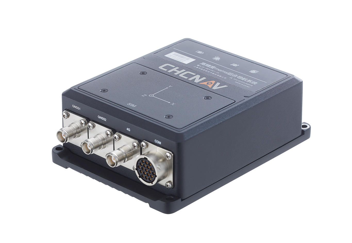
The CHCNAV CGI-610 GNSS/INS sensor is an advanced dual-antenna receiver designed for reliable and accurate navigation and positioning in challenging terrestrial, marine or airborne applications.
Designed to meet the needs of 3D positioning and autonomous vehicle guidance applications, it provides high performance in urban canyons and other harsh environments where GNSS signals are lost or degraded. Incorporating the latest GNSS technology and an industrial-grade inertial measurement unit, the sensor delivers accurate hybrid position, attitude and velocity data up to 100 Hz, driven by CHCNAV algorithms.
Its rugged and lightweight package ensures uninterrupted performance and meets high protection standards.
A roundup of recent products in the GNSS and inertial positioning industry from the December 2022 issue of GPS World magazine.
AUTONOMOUS
Flight Controller
Turns a UAV into a connected autonomous system
Photo: Auterion
Skynode reference-design hardware is built with Remote ID in mind, enabling UAV users to comply with the FCC rule Remote Identification of Unmanned Aircraft (Part 89). A built-in connectivity stack with 4G, Bluetooth and Wi-Fi enables automatic real-time data transmission from the UAV to the cloud. Built on open standards, Skynode is flexible and extensible, allowing users to leverage a variety of compatible software and hardware components. The connections enable automatic sending of logs, images and real-time video streams from the field to remote experts.
The VoloDrone is a fully electric, heavy-lift utility UAV with a range of up to 25 mi carrying a carrying a 440-lbs payload. The rotor area has a diameter of 30 ft, and the vehicle is 7.5 ft high. It can be remotely piloted or can fly autonomously on preset routes. Loads can be carried between the legs of the landing gear on standard rack mounts or slung below, or a tank and sprayer could be fitted for agricultural applications. The 18-rotor multicopter platform uses swappable lithium-ion batteries and an in-house flight control system, and benefits from existing development and test of the Volocopter air-taxi.
With a wingspan of 4.20 m, the BOREAL NRM remotely piloted aircraft integrates efficient photogrammetry devices for mapping large areas, even in areas inaccessible to traditional mapping aircraft. Its flight-control system is designed for image-capture management and optimal coverage of areas greater than 20,000 ha. The BOREAL NRM offers an overall and precise view of cultivated areas (1 cm to 3 cm per pixel), simplifying crop monitoring and facilitating human intervention in places that require it (such as water stress, treatment of pests).
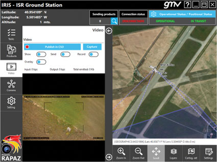
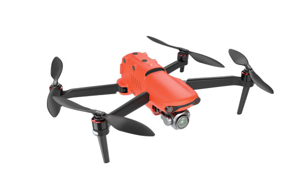
The IRIS unmanned vehicle command-and-control system provides intelligence, surveillance and reconnaissance (ISR) interoperability — essential aspects of any military operation. The IRIS system integrates unmanned vehicles with other command-and-control systems for monitoring and gathering information for a variety of operational scenarios. IRIS uses each unmanned vehicle’s own communication systems and 5G technology to provide situational awareness for decision makers before and during operations. A simplified interface allows integration of sensors and platforms into a command-and-control network, providing interoperability with other command, control, communication and computer ISR (C4ISR) systems. IRIS performed well during NATO’s REPMUS 22 (Robotic Experimentation and Prototyping Augmented by Maritime Unmanned Systems) exercise in September.
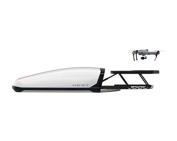
The AtlasNEST UAV system features a docking station to provide fully autonomous 24/7 readiness for infrastructure inspections, emergency situations and security missions requiring shared situational awareness and management. Using the AtlasSTATION interface, an operator sets a target destination, and the lightweight UAV deploys in less than three minutes. Sending a drone to collect visual data and reveal possible problems can help prevent putting personnel in unsafe circumstances. AtlasNEST has built-in artificial-intelligence technologies, including autonomous battery swapping. Using the AtlasSDK, AtlasNEST can be incorporated into current security systems.
Turf Tank is an autonomous, GNSS-guided line-marking robot built specifically to paint lines on athletic fields. More than 550 Turf Tank robots are deployed across the United States, painting athletic fields at public schools, major colleges and universities, amateur and professional soccer clubs, local parks and recreation departments, and at two National Football League stadiums. The Turf Tank robots can paint a full soccer field in less than 30 minutes, compared to two or three hours for manual painting. Similarly, the robot can paint a football field in two or three hours compared to eight to 10 hours to paint a football field. The robots are eco-friendly — they’re powered by rechargeable batteries and use far less paint than most older paint machines.
The Autel EVO II Pro Series combines Carlson’s software and hardware surveying and mapping solutions with a UAV from Autel Robotics. The Carlson suite is designed to take professionals throughout a project’s lifecycle: setting ground control points with the Carlson BRx7 GNSS receiver and RT4 data collector with SurvPC field software, the drone flight, PC photo and data processing, and creating finished plans in CAD.
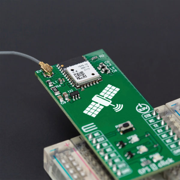
The GPS 5 Click is a compact add-on board that provides users with positioning, navigation and timing (PNT) services. The board features the M20050-1, a GPS module using the MediaTek MT3333 flash chip and an Antenova GNSS receiver for optimum performance. The receiver tracks three GNSS constellations concurrently (GPS + Galileo + GLONASS or GPS + Galileo + BeiDou) and has configurable low-power modes operating from a 3.3V power supply. In addition to the possibility of using an external antenna, backup power, and various visual indicators, the M20050-1 has an accurate 0.5 ppm TXCO ensuring short time-to-first-fix and multipath algorithms that improve position accuracy in urban environments.
Modules GT-100, GT-9001 and GT-90 are time-synchronization GNSS receiver modules compatible with all GNSS systems. The three modules deliver nanosecond precision for 5G mobile systems, radio communications systems, smart power grids and grandmaster clocks. Each suits different applications based on supported frequency bands and output signals. GT-100 supports concurrent L1 and L5 reception and delivers three outputs including 1 pulse per second (1 PPS) synchronized with UTC as well as user-programmable frequencies. The outputs can be set to 10 MHz, 2.048 MHz and 19.2 MHz, reducing time to market and saving costs through reduced component needs. GT-9001 supports L1 and delivers high-stability 1PPS and programmable clocks on three channels. GT-90 supports L1 and provides a 1 PPS high stability output. All models have time stability of 4.5 ns (1 sigma) and are equipped with multipath mitigation to minimize degradation of performance in urban areas.
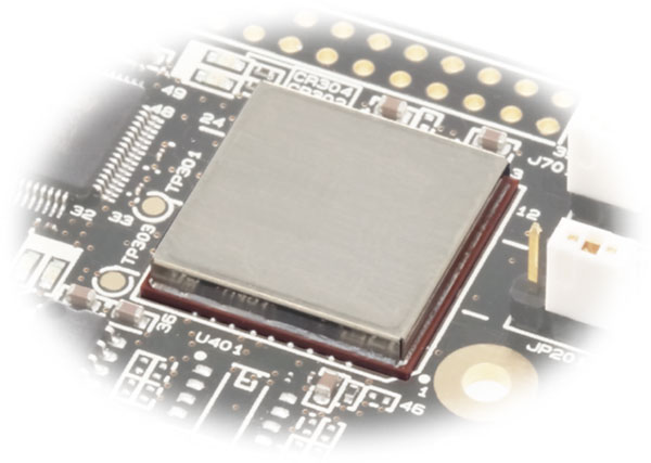
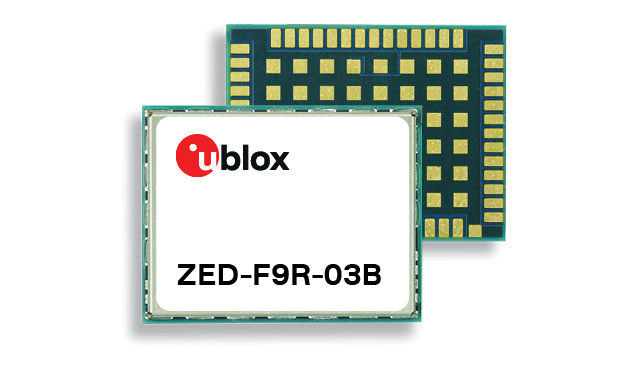
The latest firmware update for the u-blox ZED-F9R high-precision GNSS module adds support for Japan’s QZSS CLAS correction services (ZED-F9R-03B). The ZED-F9R also now supports u-blox SPARTN 2.0 correction data.
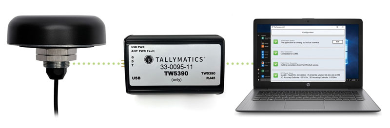
The TW5390 smart antenna has IP network and L-band augmentation service capability. Along with a Tallymatics antenna, it has a high-precision u-blox F9R GNSS receiver and DS9 L-band receiver modules. The combination delivers a reliable and convenient smart antenna yielding <6-cm accuracy, with precise point positioning/real-time kinematic (PPP/RTK) augmentation services via the PointPerfect subscription service. The antenna provides superior multipath rejection with Tallysman Accutenna technology, a low noise amplifier, Tallysman’s eXtended Filtering (XF) technology, which mitigates saturation from nearby RF signals (targeting LTE and Ligado), a tight, measured phase-center offset and low axial ratio, enabling accurate and precise positioning, direct decoding of PointPerfect, SPARTN formatted augmentation packets (u-blox specific)
Tracking enables potential applications and projects
Photo: TE Connectivity
The Lembas LTE/GNSS USB modem provides plug-and-play GNSS tracking as well as LTE and CAT4 network connectivity via a robust USB interface to a variety of small-board computers utilizing the ARM chipset. Through a single-command setup process, users can have GNSS access to a wide variety of projects. The modem has been tested with Raspberry Pi Model B, Odroid XU4 and N2, ASUS Tinker Board, and NVIDIA Jetson Nano.
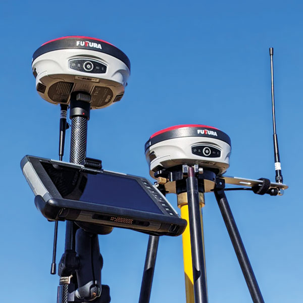
The universal construction site supervisor system is designed to help contractors manage all their job site activities. It includes the SiteMetrix Grade and the multi-frequency, multi-GNSS F631 RTK base and rover. SiteMetrix is user friendly, easy to understand and portable. Contractors can use the Futtura system to localize sites, check grade, configure base stations, set stakes and calculate volumes of material removed. Users will see the benefit of seamlessly performing data collection and layout, all in one easy-to-use application, the company says. The F631 GNSS receiver is powered by SureFix RTK technology, which offers a real-time dual-solution point verification. The F631 GNSS receiver is powered by Hemisphere GNSS’ Athena RTK technology. With Athena, F631 provides state-of-the-art RTK performance when receiving corrections from a static base station or network RTK correction system. With multiple connectivity options, the F631 allows for RTK corrections to be received over radio, cell modem, Wi-Fi, Bluetooth, or serial connection. F631 delivers centimeter-level accuracy with virtually instantaneous initialization times and robustness in challenging environments.
The Trimble GFX-1060 and GFX-1260 next-generation displays for precision agriculture applications enable farmers to complete in-field operations quickly and efficiently while also mapping and monitoring field information in real time with precision. Both displays feature an Android-based operating system and enhanced processing power for controlling and executing in-field work. The new flagship GFX-1260 is a 12-in (30.5 cm) display, while the GFX-1060 is a 10-in (25.6 cm) display, and both are compatible with the Trimble NAV-500 and NAV-900 GNSS guidance controllers. The displays are ISOBUS-compatible, which allows one display or terminal to control ISOBUS implements, regardless of manufacturer. The displays enable farmers to set up and configure their equipment through Trimble’s Precision-IQ field software, including manual guidance, assisted and automated steering, application controls, mapping and data logging, equipment profiles and camera feeds from attached inputs and other internet-based apps.
Enables affordable smart construction upgrades for fleets
Photo: Komatsu
The Smart Construction Retrofit kit turns a conventional Komatsu excavator “smart” with 3D guidance and payload monitoring. With a kit installed, an operator is no longer required to set up a laser or bench every time the machine moves. The kit’s GNSS receiver determines where a machine is on the job site and what the target grade is. The need for additional labor is reduced because the technology collects and delivers information directly to the operator. Designed to improve grading performance and provide more time- and cost-management tools, Smart Construction Retrofit kits can bring 3D to most Komatsu excavators in a fleet. The kit gives operators the latest design data, measures payload volumes and load counts, and allows managers to monitor production from the office by integrating Smart Construction applications. The payload meter helps prevent overloading trucks by promoting proper loading weights for on- and off-road vehicles, to reduce the potential for equipment damage and other risks.
The SAgro10 GNSS is an upgradeable entry-level guidance system for precision agriculture, which can be easily upgraded to the SAgro100 automatic steering system. Equipped with a high-precision GNSS module, the SAgro10 tracks all constellations. For users with network coverage or a UHF base station, the SAgro10 system provides centimeter-level accuracy navigation in real-time kinematic mode. In the absence of base stations, it can still provide sub-meter navigation accuracy in single-point smoothing mode. The system is compatible with most agricultural tractors and can be installed in 15 minutes. It supports a 10-in sunlight-readable touchscreen with a clear graphic interface. The SAgro10 software can intelligently manage the work area and simplify user operations, such as recording the completed work area and planning the work route.
The Institute of Navigation is seeking abstracts for the 2023 Joint Navigation Conference (JNC 2023) for the Department of Defense and Department of Homeland Security. The Military Division of the Institute of Navigation will host the conference taking place June 11-15 in San Diego.
The exhibit hall will be open to all conference participants, exhibitors, their employees and related organizations. All materials displayed in the exhibit hall shall be Publically Releasable After Review.
The theme of this year’s conference will be “Enhancing Dominance and Resilience for Warfighting and Homeland Security PNT”.
JNC is the largest U.S. military Positioning, Navigation and Timing (PNT) conference of the year with joint service and government participation. The event will focus on technical advances in PNT with an emphasis on joint development, testing and support of affordable PNT systems, logistics and integration.
The conference will also focus on advances in battlefield applications of GPS; critical strengths and weaknesses of field navigation devices; warfighter PNT requirements and solutions; and navigation warfare.
Abstracts must be written for public release with the intent to present in a Controlled Unclassified Information (CUI) U.S. only environment. Abstracts not approved for public release will not be accepted. Abstracts should be submitted via ion.org/abstracts by February 3.
A roundup of recent products in the GNSS and inertial positioning industry from the November 2022 issue of GPS World magazine.
OEM
GNSS Module
For UAV, precision agriculture and autonomous machines
Photo: Unicore Communications
The UM982 GNSS module is a high-precision, dual-antenna real-time kinematic (RTK) positioning and heading module. It supports BeiDou B1I/B2I/B3I; GPS L1/L2/L5; GLONASS L1/L2; Galileo E1/E5a/E5b, QZSS L1/L2/L5; and SBAS in dual-antenna mode. The highly integrated, compact (16 mm × 21 mm × 2.6 mm) module can reduce the design area of an OEM board by 72% compared to previous modules. Power consumption is less than 0.6 W. The NebulasIV GNSS system-on-chip is a key part of the UM982’s navigation system. The NevulasIV integrates RF, baseband and high-precision algorithms on a single chip, with supporting functions built in. High-level performance indicators include raw observation accuracy, RTK positioning accuracy, precise point positioning accuracy, and time to first fix. The two antennas can independently participate in deriving an RTK solution and outputting the positioning results.
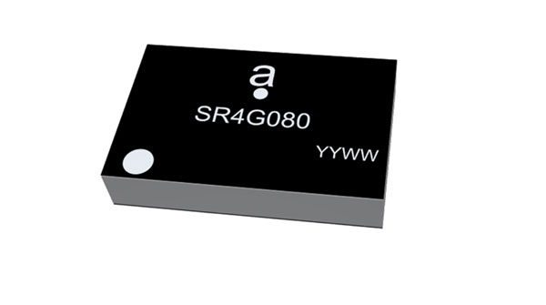
Alternative to ceramic patch provides omni-directional performance
Photo: Antenova
The Agosti (part number SR4G080) is a new miniature surface-mount-designed (SMD) antenna for GNSS applications. It measures 9.0 mm x 5.8 mm x 1.7 mm and operates with exceptional efficiency in a reduced space on a corner of a printed circuit board. It has a small ground-plane requirement of 40 mm x 20 mm, 70 mm x 25 mm and 80 mm x 30 mm, making it suitable for small form-factor designs such as wearable devices, trackers and onboard diagnostics.
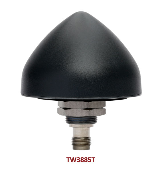
Housed Dual-Band antenna with Accutenna technology
Photo: Tallysman
The dual-band TW3885T antenna supports GPS/QZSS L1/L5; Galileo E1/ E5a/b; BeiDou B1/B2/B2a; GLONASS G1/G3; and satellite-based augmentation systems in the region of operation: WAAS (North America), EGNOS (Europe), MSAS (Japan) or GAGAN (India). It is housed in a through-hole mount, weatherproof (IP69K) enclosure. It mitigates the effects on GNSS receivers of new signals or harmonic frequencies from adjacent LTE bands on the radio-frequency spectrum. For permanent installations, L-bracket (PN 23-0040-0) or pipe (23-0065-0) mounts are available. Tallysman provides an antenna installation guide that recommends a 100 mm –125 mm ground plane and provides antenna installation and cable connector waterproofing best practices.
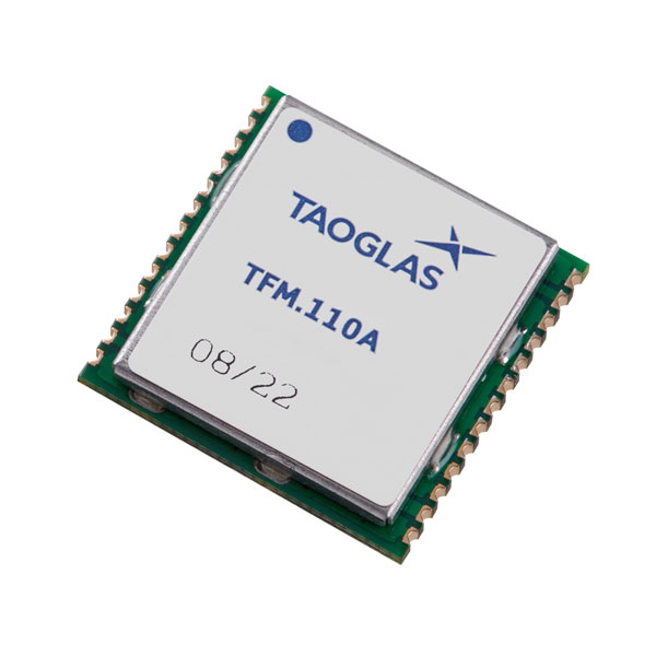
Simplifies product development for high-precision applications
Photo: Taoglas
The TFM.110A is the first in a new series of high-precision, multi-band GNSS front ends for autonomous vehicles, precision agriculture, automotive applications and robotics. It comes fully integrated with two cascaded low noise amplifiers (LNA) and pre-filters in a small, low-profile, shielded surface-mount package. When used between the device’s GNSS receiver and antenna, the two-stage amplifier solution eliminates the need for complex and challenging onboard filter and amplifier circuits. It supports L1, L2 and L5 bands and enables seamless signal transmission, signal purity and position accuracy in high-precision applications.
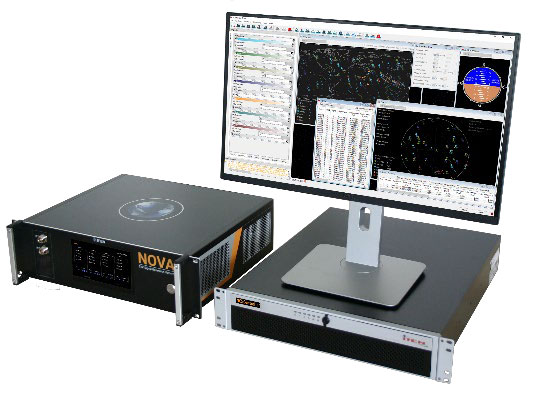
Provides interference, spoofing, encryption and authentication capability
Photo: IFEN GmbH
Version 2.8 of the NCS Nova RF signal simulator offers advanced capabilities. With integrated interference generation capability, the Nova can generate coherent interference signals with a signal power of up to –30 dBm. The ability to assign two users to one RF output enables integrated spoofing scenarios with a single RF output, meaning spoofing is available even with an entry-level single RF Nova. The new release has advanced navigation message authentication simulation capability compliant to User ICD 1.0 for the Galileo E1-B OSNMA, meaning specific OSNMA events can be simulated — key to ensuring compliant receiver behavior. Supported events include renewal and revocation of both a public key and a TESLA keychain. GPS cross-authentication and generation of Galileo E6-C encrypted codes are also supported.
Enables first responders to locate callers on floor levels
Photo: Polaris Wireless
Z-axis location service enables the pinpointing of a smartphone user within one floor level inside a multi-story building. The technology — demonstrated to meet the 3-meter vertical location accuracy requirement of the Federal Communications Commission (FCC) — is integrated into Schok Gear’s newly released flip phones. The Schok phones provide consumers with a simple, powerful device. Adding indoor and vertical location to these phones enables first responders to locate all wireless 911 callers with floor-level accuracy in multi-story buildings.
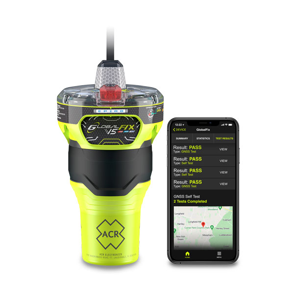
The new ACR Electronics GlobalFix V5 Emergency Position-Indicating Radio Beacon (EPIRB) and ResQLink AIS Personal Locator Beacon (PLB) have integrated the automatic identification system (AIS) to increase the speed of location and aid. They also are compatible with Return Link Service (RLS) alerting. The combination of services ensures faster rescue and increases chance of survival of both boat (EPIRB) and crew (PLB). The safety beacons deliver mobile connectivity to a cell phone with a free mobile app, made possible with the addition of near-field communication technology in the beacons. With the app, users can monitor their beacons, review self-test results, view GNSS test locations, and monitor beacon performance and maintenance by scanning the beacons with their mobile phones. Besides GNSS positioning, the lightweight beacons have 406-MHz Cospas-Sarsat distress signal with MEOSAR compatibility and 121.5-MHz local homing signal.
The Canvas Device Manager simplifies workflows for configuration and maintenance of internet of things (IoT) device deployments. It enables users to easily set up devices, monitor performance, and keep software up-to-date across the entire IoT device fleet. Device parameters can be remotely managed, and performance monitored. Canvas enables users to organize large numbers of devices to quickly build and maintain IoT solutions, and software updates can be remotely and rapidly deployed, thwarting security attacks.
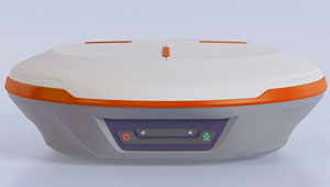
The N2 Palm RTK GNSS receiver is suitable for surveying, mapping and construction. It has a highly integrated main board and a three-in-one antenna, yet weighs 0.72 kg with battery and measures 48 mm. Powered by ComNav’s SinoGNSS K8 high-precision module, the N2 can track 1,590 channels, including all existing and planned signals of GPS, BDS-2, BDS-3, GLONASS, Galileo, QZSS and SBAS. Its advanced satellite-tracking technology ensures it works well even in harsh environments, such as under heavy foliage or close to buildings. A third-generation inertial measurement unit (IMU) makes the N2 immune to magnetic disturbance, which greatly improves its reliability. Pole-tilt compensation of up to 60° allows surveyors to locate points within 2.5 cm. By using the company’s Quantum algorithm, the N2 achieves calibration-free operation — after 10 seconds of initialization, users can make tilt measurements with centimeter-level accuracy for an extended period, greatly improving efficiency.
Airbus has added 30-cm Pléiades Neo imagery to its OneAtlas Living Library service. The new data source will complement the service which already allows users to instantly access a premium catalogue of Pléiades 50 cm and SPOT 1.5 m data via streaming, download and API. The Living Library provides frequent updates over urban areas, airports, harbors and military sites to name a few. Imagery is updated every day and processed in the cloud, with flexible options for integration into GIS workflows. With the OneAtlas Living Library, Airbus offers a pay-per-order option but also a subscription-based service that allows users to access premium content quickly available into their account, as well as a deeper archive of more than 10 years of imagery by Pléiades and SPOT satellites at a higher incidence angle and cloud coverage threshold, which will be available in just a few hours. OneAtlas also provides access to several other data services, such as reactive tasking, that allows users to task a full suite of optical and radar satellites, including Pléiades Neo, or access more than 15 years of global radar data, as well as the ability to download the WorldDEM product suite among others.
Free, user-friendly tool shows the Earth’s changes
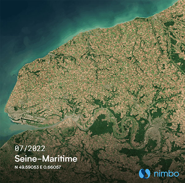
Photo: Kermap
The Nimbo Maps platform provides monthly 10 m-resolution images of changes on Earth in a user-friendly format. The images are chronological, seamless and free of clouds, and include intuitive comparison timelapse features. The platform, developed by French startup Kermap, relies on innovative artificial intelligence methods to process satellite images supplied by the European Union’s Copernicus program through its Sentinel missions. APIs automatically retrieve data extracted from satellite imagery, providing Kermap customers with real-time, strategic, value-added information in the fields of agriculture, land planning and environmental transitions. Current coverage includes Europe, the Middle East and the United States, with plans to provide global coverage by early 2023.
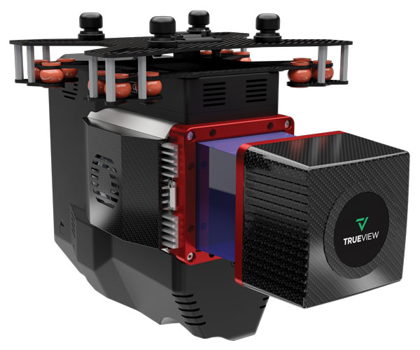
The TrueView 655/660 3D imaging system uses the Riegl miniVUX-3UAV laser scanner and three fully integrated mapping cameras (right, left and nadir) for high-accuracy mapping with excellent vegetation penetration and wire detection. Previous TrueView 3D systems carried dual oblique cameras to maximize mapping coverage. The TrueView 655/660 adds a third RGB camera, allowing for imagery directly below the sensor to be captured. The third camera provides a direct view of the ground below to maximize data collection for time flown, while improving the quality of photogrammetry and colorized point clouds.
INTERGEO, a huge geospatial conference, was hosted in Essen, Germany and digitally on October 18-20. The event was attended by 457 exhibitors from 31 countries and about 14,000 trade visitors from 102 countries. “The results clearly exceed our expectations. We are very pleased to finally be able to bring many people together again with the live event,” explained Prof. Dr. Hansjörg Kutterer, President of the organizer, DVW e.V., Association for Geodesy, Geoinformation and Land Management.
This year, INTERGEO placed a focus on digital twins. Cooperation, collaboration and the sharing of information are crucial for the success of the digitalization of city, country and space. Other focal points of this year’s INTERGEO included smart cities, building information modelling (BIM), sustainability, mobility, and climate change.
The EXPO, the event’s exhibit area, presented a broad portfolio of the geospatial industry. In addition to terrestrial recording and airborne solutions such as drones, exhibitors also presented automated solutions for recording space. Geoinformation systems and BIM solutions demonstrated their potential in data analysis, monitoring and decision support.
The DVW is also working to raise awareness for the geospatial sector and to demonstrate its potential. For the first time, Prof. Kutterer awarded the newly created “DVW Future Prize” to the “Connected Urban Twins” project with the participating cities of Hamburg, Leipzig and Munich. The DVW Future Prize is awarded for groundbreaking ideas of outstanding interdisciplinary and social significance.
To promote young talent, the DVW presented the “INTERGEO Next Generation Science and Geoinnovation Award,” honoring outstanding pitches on young researchers’ work. This year’s winner, Steffen Becker from the Karlsruhe Institute of Technology, was awarded for his master’s thesis on traffic monitoring with drones.
Next year, INTERGEO will take place in Berlin, October 10-12.