The General Assembly of the European Geosciences Union will feature a high-precision GNSS session, and is seeking paper submissions. The EGU General Assembly will be held in Vienna, Austria, April 12-17, 2015.
The conference will bring together geoscientists from all over the world to one meeting covering all disciplines of the Earth, planetary and space sciences. The EGU aims to provide a forum where scientists, especially early career researchers, can present their work and discuss their ideas with experts in all fields of geoscience.
Deadline for receipt of abstracts is January 7. To submit an abstract, visit the website.
Session G1.3 description: In the past two decades high-precision GPS has been applied to support numerous applications in geosciences. Currently, there are two fully operational Global Navigation Satellite Systems (GNSS), and two more are in the implementation stage. The new systems are about to start providing the user signals, and both, GPS and GLONASS are currently undergoing a significant modernization, which adds more capacity, more signals, better accuracy and interoperability, etc. This, however, also results in new challenges in data processing. Moreover, the new developments in GNSS stimulate a broad range of new applications.
Algorithmic advancements are needed to address the opportunities and challenges in enhancing the accuracy, availability, interoperability and integrity of high-precision GNSS applications.
This session is a forum to discuss new developments in high-precision GNSS algorithms and applications in geosciences. The organizers encourage submissions related to:
Modeling and strategies in high-precision GNSS
Multi-GNSS potential benefit for geosciences
Precise Point Positioning (PPP)
CORS services for geosciences (GBAS, Network-RTK, etc.)
Biases and calibrations
New or improved GNSS products for high-precision applications (orbits, clocks, etc.)
Ambiguity resolution and validation
Precise Positioning of EOS platforms
Precise Positioning for natural hazards prevention
High-precision applications for geosciences
Papers are welcome on all aspects of these issues.
By Ugo Celestino, European Commission, Antonella Di Fazio, Telespazio SpA, Vicente José Giner Herrera, Ineco, Patrizio Vanni, ENAV SpA, and Francisco Javier Deblas, ESSP.
This article describes a live demonstration of an aviation application in Tunisia, to help the local aviation community in validating the use of the European Geostationary Navigation Overlay Service (EGNOS) to guide airplanes during landing operations. This activity constitutes the first complete experience of EGNOS Safety of Life (SoL) service for aviation approaches outside Europe. We present here the obtained results that are useful not only for Tunisia, but as a valuable case study for other countries outside Europe interested in using EGNOS in aviation.
EGNOS, operational since 2009, has a European regional coverage that could be quite easily extended to areas adjacent to European Union through the deployment of limited additional ground infrastructure elements, but sharing the same existing space segment and leveraging the other core ground infrastructure.
The European Commission has put in place a series of actions since 2006 to support the EGNOS service extension in neighbouring areas. The MEDiterranean follow-Up for EGNOS Adoption (MEDUSA) is an on-going European initiative related to EGNOS extension in the Euromed region, including North African and Middle East countries around the Mediterranean basin: Algeria, Egypt, Israel, Jordan, Lebanon, Libya, Morocco, Palestine, Syria, and Tunisia. MEDUSA runs a program of technical assistance action in these Euromed countries, in order to prepare them for an optimal adoption and exploitation of European GNSS services in their priority market segments.
The Mediterranean Extension of EGNOS
EGNOS is Europe’s first venture into satellite navigation and paves the way for Galileo, Europe’s independent global satellite navigation system currently under deployment.
EGNOS is a satellite-based augmentation system (SBAS), whose signal is compliant to the international SBAS interoperability standards: standards – MOPS (Minimum Operational Performance Standards) and ICAO SARPs (International Civil Aviation Organization Standard and Recommended Practices). In its current version (V2) it augments the open public service offered by the American Global Positioning System (GPS), by providing correction data that enables to improve GPS position accuracy, and provides integrity information about the GPS system (integrity information is fundamental for aeronautical applications like approaches). EGNOS is interoperable with the other equivalent regional systems. Today other SBASs are the U.S Wide Area Augmentation System (WAAS), the Japanese Multi-functional Satellite Augmentation System (MSAS), the Indian GPS Aided Geo Augmented Navigation (GAGAN) and the Russian System for Differential Correction and Monitoring (SDCM). The future version (V3) of EGNOS will augment Galileo signal as well.
Today EGNOS is operational, and available for use in aviation since 2011, giving opportunities for users to have more accurate and reliable positioning for enhancing existing applications, developing new applications and particularly the safety critical ones. Already more than 150 landing procedures are operational across Europe (some of them also in countries out of the European Union, such as Switzerland, Norway, Guernsey), with many others under development to reach 100 percent Approaches with Vertical Guidance (APV) coverage in the European instrumental runways as per ICAO recommendation.
EGNOS provides three services:
EGNOS Open Service (OS), launched in 2009, is delivered free of charge. It is open for use to anyone with an EGNOS-enabled receiver. This can be any receiver compatible with satellite-based augmentation systems. Being based on GPS, the EGNOS signal does not require major changes for receivers. Today, many mass market receivers available on the market are also EGNOS enabled. EGNOS OS is particularly suitable for mass market and some applications like surveying.
EGNOS Safety-of-life Service (SoL) is authorized for European civil aviation and operational since March 2011. EGNOS SoL delivers the integrity message providing the verification of the GPS system and timely warnings (within six seconds), when the system or its data should not be used for navigation. Since integrity relates to the trust that can be placed in the correctness of the location information supplied by GPS, thanks to this feature EGNOS is able to meet the demands of safety-critical applications in sectors such as aviation.
EGNOS Data Access Service (EDAS) launched in 2012, delivers a terrestrial commercial data service. It consists of a server that gets the data directly from EGNOS system and disseminates it via terrestrial networks in real time, within guaranteed maximum delay, security and performance. EDAS is particularly suitable for professional applications. It provides EGNOS raw data and corrections enabling software solutions that implement products and value added services built on them.
EGNOS infrastructure consists of three geostationary satellites over Europe and a network of ground stations (Ranging and Integrity Monitoring Station – RIMS) located to provide services whose coverage includes southern Europe, North Africa and some Middle East countries.
The EGNOS RIMS network supports a flexible network geometry that gradually adapts to service coverage requirements evolution. From the originally envisaged coverage over European Union’s countries, the EGNOS RIMS network is being expanded over Europe’s neighbouring areas, thus increasing the number of beneficiary countries. EGNOS SoL service is highly sought by several non-EU countries for the benefits it can bring to their civil aviation, in providing a solution to comply with ICAO requirements for Performance Based Navigation (PBN).
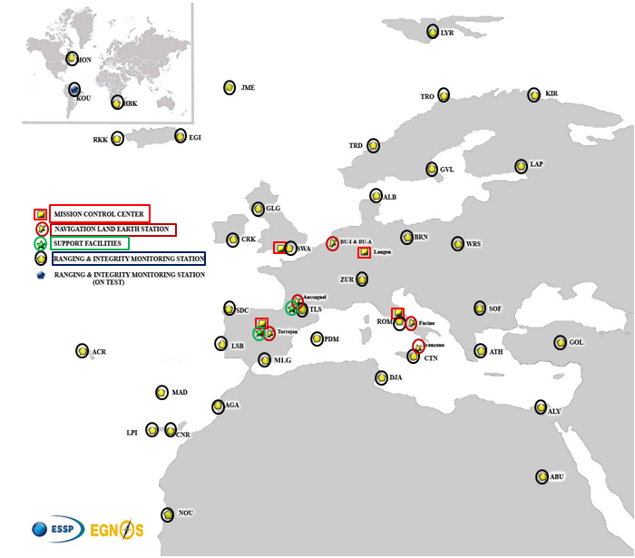
The present layout of the EGNOS RIMS network is presented in Figure 1.
Figure 1. EGNOS ground segment.
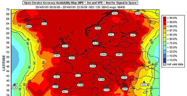
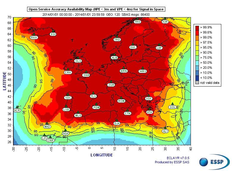
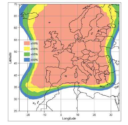
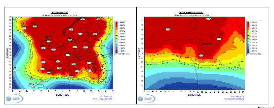
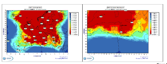
Figures 2 and 3 show respectively today’s coverage of EGNOS OS availability (source: European Satellite Services Provider, the service provider of EGNOS) and the APV-I availability performance commitment provided by EGNOS SoL (source: EGNOS Safety of Life Service Definition Document, EGN-SDD SoL, V2.0, European Commission, 2013), obtained relying on the above presented ground segment.
Figure 2. EGNOS OS Availability.
EGNOS OS Availability. The Figure 2 map is obtained by projecting the error at pseudorange level into the position domain. The computed error assumes that the GPS satellites used are those with an elevation angle above the local horizon (with a mask angle of 5º) and does not consider any possible factor depending on local characteristics that could produce different results (optimistic or pessimistic) with respect to the results computed using real receivers located in the considered areas. Moreover, it represents an estimation of EGNOS OS availability during a very limited period of time being an estimation, thus it does not imply any commitment or reference for the performances which can be obtained during different periods.
Figure 3. EGNOS APV-I Availability.
Other initiatives for a further extension in North Africa and Middle East are already being developed, under the umbrella of the Euromed GNSS programme. In parallel with the infrastructure deployment, the Euromed GNSS programme also includes actions to support the introduction and exploitation of EGNOS services. The first stage was completed in the frame of the Euromed GNSS I/MEdiTerranean Introduction of GNSS Services (METIS) project in the period 2006-2009, the second stage is presently running in the frame of the Euromed GNSS II/MEDUSA project. Further initiatives are being planned for 2015 and beyond.
EGNOS Use in Aviation
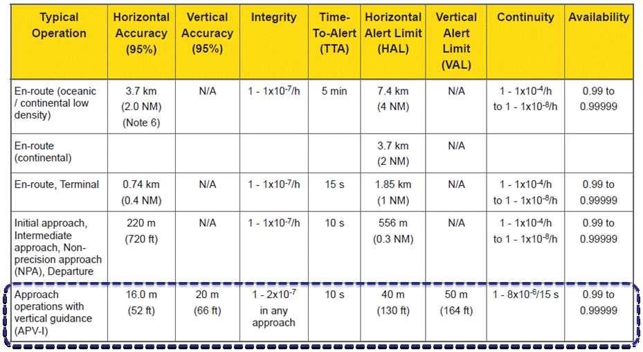
EGNOS was initially designed and developed to be used in aviation, similarly to the U.S. Federal Aviation Administration WAAS, to support different types of aviation applications and, in particular, to meet the performance requirements set by the International Civil Aviation Organization (Annex 10) for the implementation of APV-I, which enable the implementation of LPV final approaches, as reported in Table 1.
Table 1. ICAO Operational Requirements.
EGNOS is one of the GNSS elements recognised by ICAO (Annex 10) as a radionavigation aid. It is an important element of a global SBAS systems mosaic, that started with the American system WAAS in 2003, and that is gradually completed by other more recent SBAS: EGNOS itself, MSAS (Japan), GAGAN (India), SDCM (Russia), and some countries like Australia and South Korea that have launched feasibility studies to develop their own SBAS.
It is expected that, in a not too far future, most parts of the world will profit from SBAS services, following the current coverage extension plans and SBAS system evolutions. The final objective, as also shared at ICAO level, is that as many airdromes worldwide, as possible, can offer instrument approaches with vertical guidance, with an outstanding increase in global safety rates.
Additionally, the use of EGNOS allows taking full advantage of GNSS for all phases of flight, including final approach. Therefore, EGNOS means for aviation a fundamental and strategic tool to help meet ICAO’s recommendations, aimed at the adoption of a PBN oriented airspace use policy, for all countries. The 37th Assembly of ICAO (28 September – 8 October 2010) resolved that APV procedures should be implemented as either a primary or backup strategy for precision approaches at all instrument runway ends by 2016.
APV is a major safety initiative. ICAO recognises SBAS and Barometric Vertical Navigation (Baro-VNAV) as the two acceptable (and often complementary) means of implementing APV procedures, which are safer than NPA (Non Precision Approach).
GNSS based navigation enables RNAV (aRea NAVigation) with a higher cost effectiveness in comparison with the old conventional, sensor ground-based, navigation procedures. This is especially true for wide, even desert unequipped areas (or difficult to maintain) like those in North Africa and Middle East.
EGNOS benefits are maximized in final approach manoeuvres, providing GNSS lateral and vertical guidance, and enabling APV-I approaches.
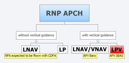
Final approach procedures based on GNSS are classified as RNP approaches (RNP APCH, as shown in the next figure), namely: Lateral Navigation (LNAV) with GPS lateral guidance and no vertical guidance; LP with GPS + SBAS (EGNOS) for lateral guidance (CAT-I localizer performance) and no vertical guidance; Lateral Navigation/Vertical Navigation (LNAV/VNAV) with GPS lateral guidance and Baro-Vertical Navigation (VNAV) vertical guidance (Baro-VNAV approach procedures can be flown with SBAS vertical guidance upon the approval of the Air Navigation Service Provider (ANSP)) and the LPV (Localizer Performance with Vertical Guidance) with GPS + EGNOS for both lateral and vertical guidance.
Figure 4. RNP approaches.
Those procedures not including vertical guidance are intended to be flown with the Constant Descent Final Approach (CDFA) technique (to avoid dangerous dive and drive practices), supported by most Flight Management Systems (FMS).
Regarding the operational LPV main figures, the European regulation (EU OPS -REGULATION (EC) No 859/2008 usually known as EU OPS) allows LPV operational minima (Decision Height – DH) down to 250 ft, expected to be possibly lowered down to 200 ft by 2015 (LPV-200), similarly to what is already permitted by the FAA, in the United Sates for WAAS based LPV approaches (a DH of 200 ft would make LPV approaches very competitive, when benchmarked against ILS CAT-I, precision approach, or even Ground Based Augmentation System (GBAS) CAT-I precision approach).
In the last few years, about 150 LPV procedures (status as of July 2014) have been published in European airports, and the number of procedures and countries introducing EGNOS is continuously increasing.
Euromed GNSS I/METIS and Euromed GNSS II/MEDUSA
In parallel with the development of the infrastructures necessary for extending EGNOS availability across the Euromed region, the European Commission has put in place initiatives to prepare and assist the Euromed countries for the optimal use and adoption of the relevant services.
These consist in two sequential projects, the first being Euromed GNSS I/METIS project and the second being Euromed GNSS II /MEDUSA.
Running from mid 2006 up to the end of 2009, METIS acted as a pioneer in the Euromed countries and built national/regional liaisons with decision-makers and key stakeholders, interested in sharing experience and absorbing know-how. The project assisted the 10 Euromed countries to identify their priorities in relation to the use of EGNOS services, to validate the relevant opportunities from the strategic/social and economic perspectives, and to elaborate a suitable strategy and a plan of actions for facilitating EGNOS adoption and exploitation.
MEDUSA Case Study in Tunisia: LPV Approaches in the Airport of Monastir Using EGNOS
As part of the technical assistance actions programme in the priority domains, MEDUSA implements demonstrations and validations of EGNOS services in concrete applications.
For EGNOS SoL, the technical assistance action consisted in the validation of GNSS approaches, including LPV approaches, designed and constructed in MEDUSA along with the relevant safety assessment and business case for the airport of Monastir in Tunisia (35°45’29’’ N 10°45’17’’ E). The selection of the airport was driven by a trade off between the EGNOS service availability with required APV-I performances and the specific needs of the Tunisian Air Navigation Service Provider – ANSP (OACA, Office de l’Aviation Civile et des Aéroports). According to OACA, Monastir is among the airports in Tunisia presenting favourable conditions, in terms of operational constraints and traffic, for concretely proving the added value of EGNOS for final approaches.
The airport has two runways, RWY 07 and RWY 25, the former is equipped with an ILS CAT-I, the latter only supports NPA approaches. The installation of an ILS in RWY 25 was discarded due to technical constraints. This infrastructure has proven to be insufficient to fully cover the airport needs, that suffers some Delays-Diversions-Cancellations (DDCs) as a result of local specific meteorological conditions, frequent fog banks entering from the sea in the early morning, combined with desert haze. These conditions make LPV ideal procedures, as backups to RWY 07, and enabling APV approaches to RWY 25. Finally, Monastir’s TWR ATC (Tower Air Traffic Control ) staff has been involved in OACA’s PBN development, for which they were ideal candidates to evaluate the benefits possibly achievable from the use of EGNOS.
This MEDUSA’s technical assistance action is the first complete experience for the use of EGNOS SoL service outside Europe. It was conceived as a realistic exercise of RNP APCH procedures implementation, following the guidelines provided by ICAO in the “EUR RNP APCH Guidance Material (EUR Doc 025)” and including all the activities required, from the scenario adequacy study to flight validation and the requirements analysis for the final publication in the AIP (Aeronautical Information Publication). OACA was directly involved in all activities, providing inputs/feedbacks and for training purposes.
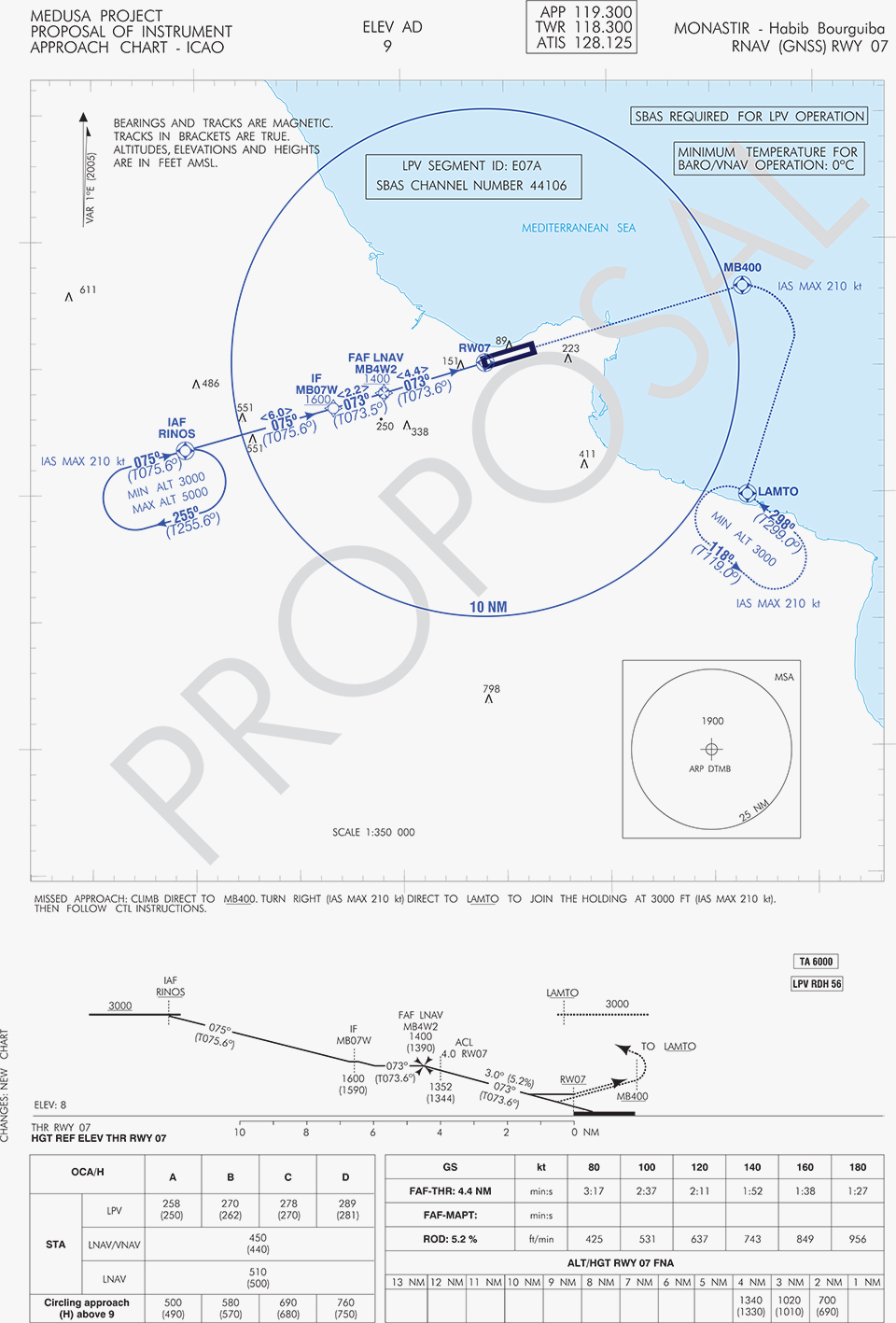
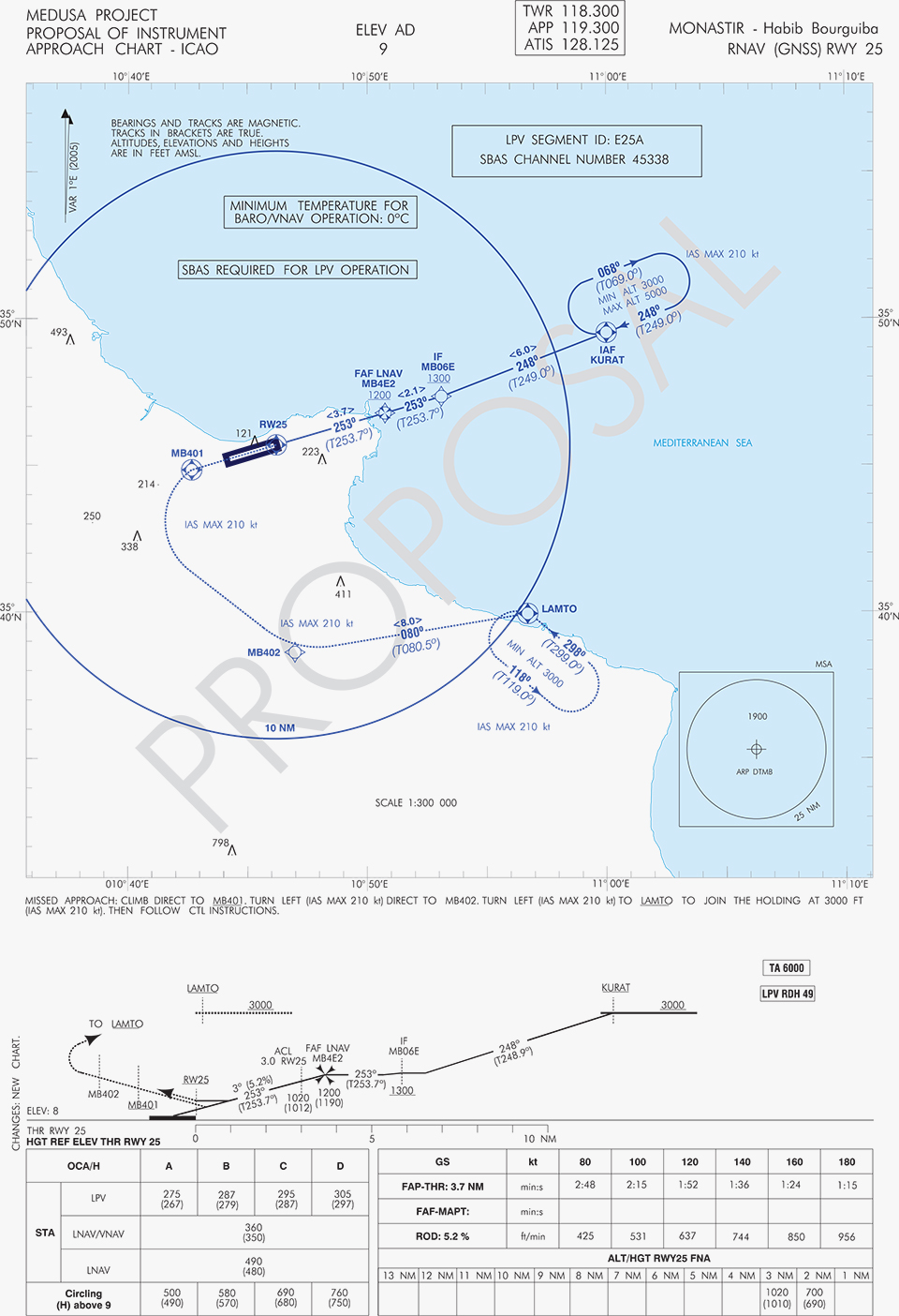
A set of three GNSS based approach procedures was produced for each RWY, following ICAO 8168 PANS OPS design principles. The next figures show the combined charts type elaborated, that include minima boxes for three RNP approaches (LNAV, LNAV/VNAV and LPV). The procedures construction preserves the current Monastir arrivals structure, following airspace management principles and facilitating the operational approval. As illustrated in the charts, in both cases for the three minima the calculated OCH (Obstacle Clearance Height) values improve with respect to the already existing conventional approaches, providing significant operational and safety benefits.
Figure 5. GNSS approaches for RWY 07.Figure 6. GNSS approaches for RWY 25.
An on-site GNSS performance monitoring campaign was performed by OACA, with the support of GEMCO’s staff, 3 months before the flight trials schedule, covering both EGNOS and GPS signal performances. Besides, an APV-I availability study for the area and specifically for Monastir airport during 1 month before the flight validation was purposely elaborated by the European EGNOS service provider (ESSP). Both analyses, confirmed suitable APV-I performance in terms of availability and continuity, making feasible the implementation of LPV approach procedures in line with ICAO prescriptions.
The next figures show the EGNOS APV-I availability and continuitymeasured on one day during the period of the flight validation (conducted from 30 January to 1 February 2014), in particular at Monastir airport for the considered time-lag:
APV-I availability was over 99%;
APV-I continuity presented a total value lower than 5×10⁻⁴/15s;
95th percentile of Horizontal APV-I accuracy was between 1.1 and 1.2 meters and the 95th percentile of Vertical APV-I Accuracy is around 1.4 meters, thus showing a very good accuracy level;
Horizontal and Vertical safety indexes were lower than 0.25, representing a very good integrity margin.
Additionally, the results of the on-site GNSS performance monitoring campaign showed quite stable performances with small fluctuations during the whole period of observation, and no problems or outages were observed.
(EGNOS APV-I Availability is defined as the percentage of epochs in a month in which the Protection Level are below Alert Limits for this APV-I service (HPL<40m and VPL<50m) over the total period (source: ESSP).
EGNOS APV-I Continuity Risk is defined as the result of dividing the total number of single continuity breaks using a time-sliding window of 15 seconds by the number of samples with valid and available PA navigation solution. A single continuity break occurs if the system is available at one epoch and becomes not available for the following 15 seconds (source: ESSP).)
Figure 7. APV-I availability on 31.01.2014.Figure 8. APV-I continuity on 31.01.2014.
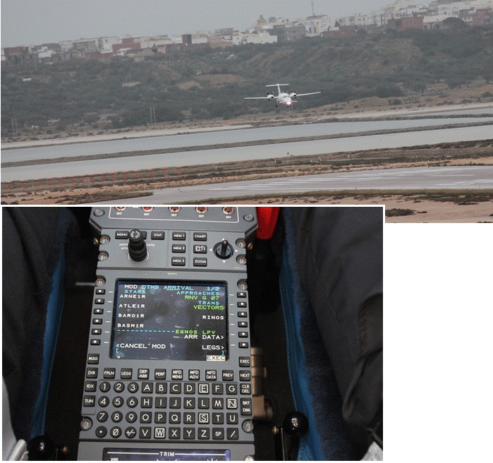
The flight validation campaign was carried out according to ICAO doc 9906 with a Piaggio P180 Avanti II (from ENAV flight inspection department) suitably equipped with UNIFIS 3000 system and a Rockwell Collins FMS 3000 with SBAS LPV approach capabilities.
Figure 9. Piaggio P180 Avanti II aircraft and the FMS messages during the flight validation.
The outcomes of this concrete experience have allowed the Tunisian authorities to identify the main elements for the publication of the validated procedures in their national AIP. They have also contributed to the analysis of the necessary process for the operational adoption of GNSS, including EGNOS, in aviation in countries beyond the EU boundaries.
The activities performed on performance assessment have been preparatory for discussions on GNSS monitoring and data recording on going at ICAO Navigation System Panel level, that would produce ICAO guidelines for States.
Therefore, this Tunisia’s “case study” represents a practical and realistic example that could be beneficial for the other non-EU countries in terms of best practice and lesson learnt. Moreover, methodology and guidelines have been derived to be possibly injected to other non-European countries interested to introduce EGNOS operations in aviation.
Lessons Learned and Outlook
Through its achievements, MEDUSA is opening the way for the introduction of EGNOS SoL service in North Africa and Middle-East region, and it is also defining a suitable path to be followed by other interested non-European countries. Overall, MEDUSA is continuing to confirm the ability to foster cooperation and involvement in EGNOS programme of the great majority of the Euromed countries. Further to Tunisia, other Euromed countries have already expressed their interest in relation to the EGNOS use in aviation, considering each country’s strategy and also in the light of a common shared regional perspective. Besides, the results obtained by MEDUSA are useful also for other regions interested to use EGNOS in aviation.
Additionally, MEDUSA is clearly showing that Euromed region, presently lacking the full support of SBAS technologies, represents an opportunity for EGNOS service extension, with many benefits for the countries of the region and for Europe.
On one hand, being SBAS an effective and efficient technology to enable the aviation community of the Euromed countries to comply with ICAO recommendations on PBN implementation by year 2016 across the region, the services coverage extension of existing SBAS systems (EGNOS in the case of the Euromed countries) can be one of the most efficient ways to move forward. In fact, the Euromed national ANSPs consider the readiness of EGNOS SoL service as one of the main drivers and factors when designing their PBN strategy. EGNOS, which is already operational since 2009 and available for use in aviation since 2011, can deliver added-value services to the Euromed region, just by leveraging the existing European infrastructure with only incremental, marginal and natural extension. The EGNOS coverage extension across the Euromed region can provide significant benefits and particularly to those Euromed countries with few ILS or reduced navaids coverage, and enhance safety and efficiency to the whole aviation community.
On the other hand, the European Union has to gain from an EGNOS-based long term links with its neighbouring regions, by increasing bilateral/multilateral cooperation and interaction (e.g. assistance, mutual cooperation) among public and semi-public bodies (e.g. ANSPs, Civil Aviation Authorities), by strengthening EGNOS SoL coverage in the southern/peripheries of EU (e.g. Malta, Cyprus, Greece, Southernest Italian islands, Canary islands), by pursuing and supporting other EU policies in several sectors (like transports, e.g. harmonizing aviation safety standards across the Mediterranean, Transport Policy of the Mediterranean Partners), and last but not least by achieving a first step towards EGNOS extension to the whole African continent which will bring in similar, additional benefits just described above.
Will Be Employable for Surveying, Precise Positioning, and Geodesy
By Peter Steigenberger and André Hauschild, German Aerospace Center (DLR) / German Space Operations Center
The first Full Operational Capability (FOC) Galileo satellite started transmitting L-band navigation signals on November 29, 2014. Based on data collected by a global network of GNSS tracking stations of the Cooperative Network for GNSS Observation (CONGO) and the Multi-GNSS Experiment (MGEX) of the International GNSS Service (IGS), we determined that an E1 signal with pseudorandom noise code (PRN) E18 was first tracked at the station LLAG (La Laguna, Tenerife, Canary Islands) at 06:08 UTC. A few moments later, the satellite’s transmissions were also tracked at other MGEX stations including the E5a, E5b, and E5 AltBOC signals. Based on the computed satellite visibility at various tracking stations, the satellite could be positively identified as GSAT0201, also known as Galileo FOC-FM1 or Galileo 5 with COSPAR ID 2014-050A and NORAD ID 40128.
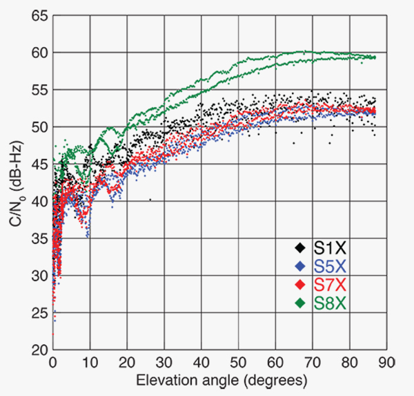
FIGURE 1 shows the carrier-to-noise-density ratio (C/N0) of the E18 signals tracked at the CONGO/MGEX station SIN1 (Singapore, using a Trimble NetR9 receiver with a Leica AR25.3 antenna). We selected the signals from this station for analysis due to an E18 pass occurring close to the zenith and covering almost the full range of elevation angles. The E5a and E5b signals (S5X and S7X RINEX identifiers) show very similar performance, whereas the C/N0 values of the E1 signal are 1–2 dB-Hz higher. The C/N0 values of the E5 AltBOC signal (S8X) reach 60 dB-Hz at high elevation angles, which is about 6 dB-Hz higher than the other signals.
Figure 1. Galileo E18 carrier-to-noise-density ratio for the CONGO/MGEX station SIN1 (Singapore).
The first pair of Galileo FOC spacecraft was launched on August 22 with a Soyuz launcher from the Guiana Space Centre, Kourou, French Guyana. Due to a malfunction of the Fregat upper stage, the satellites were injected into elliptical orbits with an inclination of about 49° instead of near circular orbits with 55° inclination. In November, the perigee of the first FOC satellite was raised by about 3,500 kilometers by a series of 11 maneuvers with a corresponding reduction in orbit eccentricity from 0.23 to 0.16.
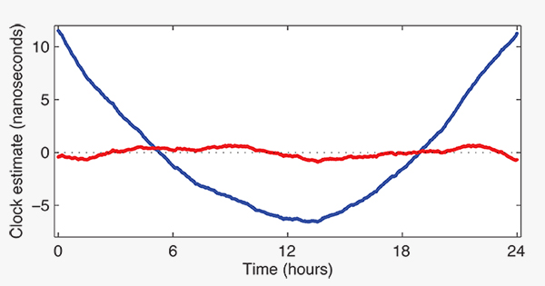
E18 has been included in the precise orbit and clock solutions of the MGEX analysis center at Technische Universität München (TUM) in Munich, Germany, since December 5. FIGURE 2 shows the detrended estimates of the active Galileo E18 clock for December 7. The presence of a pronounced quadratic term as well the large drift of 33.9 microseconds per day indicate that the active clock is a rubidium atomic frequency standard rather than a more precise passive hydrogen maser. The FOC satellites carry two of each kind of clock.
Figure 2. Galileo E18 clock estimates for December 7, 2014, with respect to the hydrogen maser at the Ottawa IGS station (NRC1) after removing an offset and drift (blue) or a second order polynomial (red).
The TUM orbit and clock product allows researchers to again compute dual-frequency positioning solutions using only Galileo observations, as the In-Orbit Validation satellite E20 has not transmitted an E5 signal since May, when a power anomaly left the satellite with the capability to only transmit an E1 signal. Furthermore, E20 currently does not transmit a navigation message.
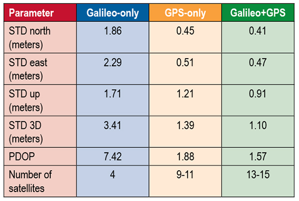
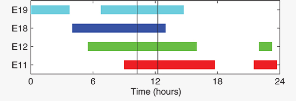
TABLE 1 shows the scatter of single-point positioning using pseudorange (code) observations from the MGEX station MAS1 (Maspalomas, Gran Canaria, Canary Islands) for a Galileo-only, a GPS-only, and a combined Galileo+GPS solution for December 6. At an elevation cut-off angle of 10°, four Galileo satellites were visible from 10:15 until 12:25 UTC (see FIGURE 3). The GPS-only solution covers the same time interval. The start time is not limited by the cut-off angle but an E18 transmission outage from 3:45–10:15 UTC.
TABLE 1. Single point positioning results for the MGEX station MAS1 (Maspalomas) for December 6, 2014.Figure 3. Galileo visibility at the MGEX station MAS1 (Maspalomas) on December 6, 2014. The time period considered in the single-point positioning is indicated by vertical lines.
We used an ionosphere-free linear combination of Galileo E1 and E5 AltBOC code observations and GPS L1 and L2 code observations with a 30-second sampling interval. As the Galileo-only solution suffered from position dilution of precision (PDOP) values of up to 830, a total of 32 epochs with PDOP values greater than 25 were excluded. The geometry of the remaining epochs is still pretty unfavorable. At a mean PDOP value of 7.4, the standalone position solution exhibits a 3D standard deviation (STD) error of 3.4 meters. Use of the Galileo satellites in a combined GPS+ Galileo solution improves the positioning performance. In particular, the height component benefits from the inclusion of the four Galileo satellites with a standard deviation improvement of 25 percent.
Despite the orbit injection error, the new Galileo FOC satellite has now been successfully activated and added to the Galileo constellation. Unfortunately, the current orbit is incompatible with the standard Galileo almanac format, which may cause restrictions for some commercial receiver types.
Nevertheless, the satellite can already be tracked by a wide range of geodetic receivers with existing firmware versions and it will, in fact, be possible to use the new satellite for diverse applications in surveying, precise positioning, and geodesy, as well as in general multi-GNSS studies. We now look forward to the activation of the second FOC satellite, which can be expected in early 2015 and will, for the first time, offer multi-frequency signals from a total of five Galileo satellites.
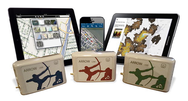
Eos Positioning Systems has introduced a new line of high-accuracy GNSS receivers for smartphones and tablet computers, including both sub-meter and RTK performance for all mobile platforms: iOS, Android, and Windows.
Eos’s entry-level product, the Arrow Lite, is Bluetooth compatible with all mobile devices.
The Arrow 100 is Eos’s advanced real-time, sub-meter GNSS receiver that utilizes both GPS and GLONASS, and is expandable to Galileo, Beidou and QZSS. It offers superior tracking under tree canopy, around buildings and in rugged terrain, the company said. In addition to supporting SBAS in North/Central America, Europe, Northern Africa, Japan, India and Russia, the Arrow 100 also supports OmniSTAR’s worldwide, real-time sub-meter service.
The most advanced Arrow receiver is the Arrow 200, a dual-frequency, multi-constellation RTK GNSS receiver capable of 1-cm accuracy in real time. The Arrow 200 is an iOS-compatible RTK and OmniSTAR receiver that works with all models of iPads and iPhones via wireless Bluetooth connection. An iOS NTRIP app that allows the user to log into any available RTK network. The Arrow 200 will provide quality RTK performance for years to come because it supports current and future satellite constellations: GPS, GLONASS, Galileo, BeiDou and QZSS, the company said. It also supports OmniSTAR’s G2, XP and HP real-time worldwide decimeter services.
“After spending more than 12 years designing high-accuracy Bluetooth GNSS receivers, I believe Eos has set the new standard for high- accuracy GNSS receivers that work across all mobile platforms, no matter if it’s iOS, Android or Windows,” said Chief Technology Officer Jean-Yves Lauture.
All Arrow receivers employ long-range (1-km) universal Bluetooth connectivity so the user can interface to any brand of smartphone or tablet, whether it’s iOS, Android, or Windows-based. A variable-power Bluetooth implementation allows the Arrow receivers to communicate up to one kilometer from the mobile device.
Arrow receivers have been optimized to run all day on battery power. The battery pack is field-replaceable and rechargeable separately. It contains smart charging logic so expensive battery chargers are not needed.
All Arrow receivers have been designed to meet IP-67 specifications for immersion in water and are completely dust-proof so they will survive in the harshest environments.
The Arrow receiver product line is targeted at high-accuracy applications like GIS, environmental, agriculture, electric/gas/water utilities, surveying, machine control, and federal/state/local government.
According to the GLONASS satellite manufacturer, the company will now produce nine GLONASS-K1 satellites rather than move to GLONASS-K2, because of the sanctions restricting the delivery of radiation-resistant electronic components from the West.
Nikolai Testoyedov, CEO of Information Satellite Systems Reshetnev, told the Russian magazine Vestnik GLONASS, “For a smooth transition to a multi-functional group and due to issues with the very complex GLONASS-K2 satellites, we decided to continue with the GLONASS-K1 intermediate range of satellites, and we are preparing for the launch of nine units of this series.”
He said the original plan was to launch two K1 satellites and then move to GLONASS-K2 satellites.
“In the beginning, really, we wanted after the two GLONASS-K1 satellites No. 11 and 12, to go for the launch of more advanced GLONASS-K2 devices. But, unfortunately, the plans had to be adjusted somewhat because of the sanctions restricting the delivery of radiation-resistant electronic components from the West. We have to put a hold on the in-depth development of technical and technological documentation and that delays us in terms of moving ahead by at least a year or two,”he said.
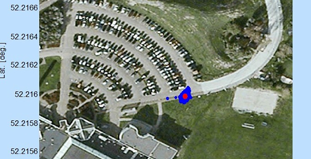
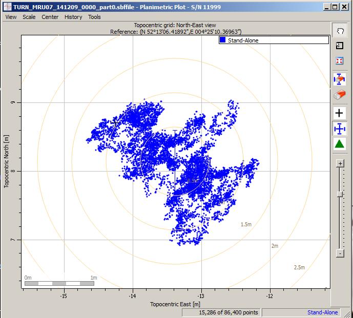
Scatter plot of the Galileo fix performed in ESA’s Navigation Laboratory at its ESTEC technical centre on 9 December 2014. The plot was calculated by the Lab’s Septentrio Test User Receiver, with dispersion of less than 2 m.
News from the European Space Agency
Galileo’s fifth satellite — recently salvaged from the wrong orbit to begin navigation testing — has been combined with three predecessors to provide its first position fix.
Test receivers at ESA’s technical centre in Noordwijk, the Netherlands, and at the Galileo In-Orbit Test station at Redu in Belgium received the signals at 12:48 GMT on December 9 from the quartet of satellites and fixed their horizontal positions to better than 2 meters.
This achievement is particularly significant because the fifth satellite is the first of a new design of 22 Galileo satellites set to be launched over the next few years.
Further position fixes were then made by France’s CNES space agency in Toulouse, France, as noted by Bernard Bonhoure: “The results are as good as those for the first Galileo fixes in 2013 with the initial four satellites.”
The following day, fixes were performed using Galileo’s Public Regulated Service, the encrypted highest-precision class of signal.
“The very good geometry of the satellites in the sky relative to the receivers helped us to achieve this result, plus the signal strength of the fifth satellite,” explained Gustavo Lopez Risueno, coordinating the receiver team at the Navigation Laboratory in ESA’s ESTEC technical centre.
“This is a significant milestone for the Galileo program because it marks the very first time that a Full Operational Capability satellite has performed a fix together with its In-Orbit Validation predecessors — which were the first four satellites launched into orbit, in 2011 and 2012. This establishes they work together well.
“While it is not yet possible to make routine use of the fifth Galileo, this shows such an outcome is within our reach.
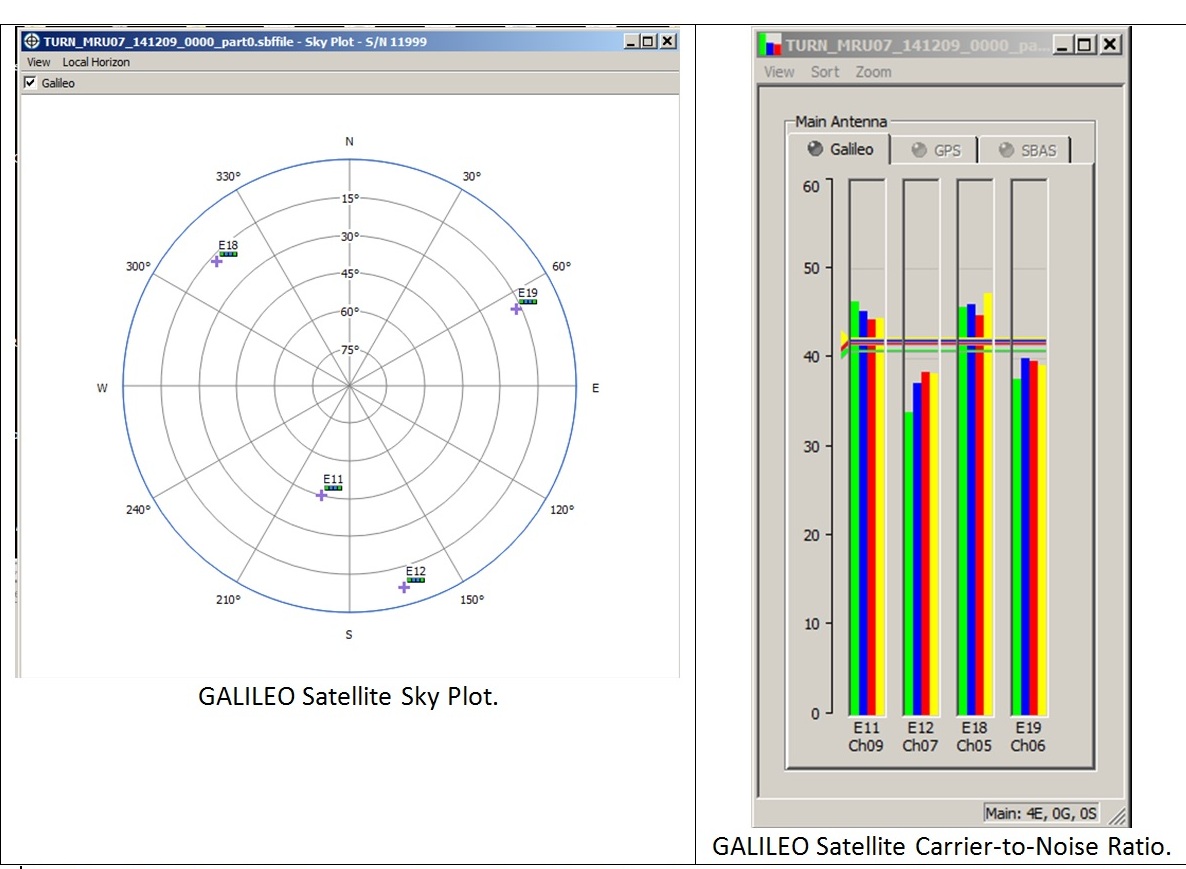
Galileo satellite geometry and received signal strength for the December 9 fix using the first Galileo FOC satellite. The first Galileo FOC satellite corresponds to E19 on the left display; IOV PFM to E11, FM2 to E12 and FM3 to E19.
“In particular, it opens the door to its immediate use in combination with additional navigation message information provided through ground networks, which is a standard mode of operation for mass market receivers, such as those found in our smartphones.”
The fifth and sixth satellites were delivered into the wrong orbit by their Soyuz–Fregat rocket in August. Their elongated orbit took them out to 25,900 km above Earth and back down to 13,713 km, rather than the planned circular path at 23,222 km. The angle of the orbit to the equator was also wrong.
The satellites’ shifting altitude left them unable to lock onto Earth for part of each orbit, preventing them from being used for navigation purposes.
But, last month, a series of 11 maneuvers took the fifth satellite into a more circular orbit, some 3500 km higher, allowing its navigation payload to be switched on for testing. A similar salvage operation is planned soon for its companion.
The main hurdle in using the fifth (and subsequently sixth) satellite operationally is that mass market receivers in particular might take longer to find it. Their orbits fall outside the almanacs satellite-locating standard broadcast within navigation messages.
Utilizing navigation-assistance information would be a way of shortening acquisition times — and ESTEC’s Navigation Laboratory has already demonstrated it with mass market receivers.
Working in conjunction with the European Commission and Europe’s Global Navigation Satellite Systems Agency, the Lab performed position fixes with both Galileo and GPS satellites using only navigation-assistance information.
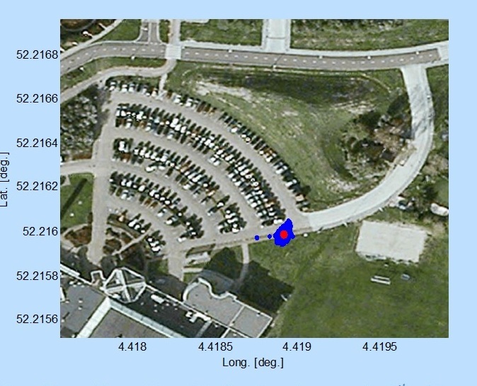
Test position fix in the grounds of ESTEC, performed with a mass-market receiver using navigation-assistance information, based on signals from the fifth Galileo satellite plus GPS satellites. This satellite’s elliptical orbit means extra data are needed to speedily utilize its signals, which could be provided through ground networks. Navigation-assistance information is already employed by the mass market receivers found within smartphones. Source: European Space Agency
EDITOR’S NOTE: Researchers at the German Aerospace Center (DLR) report on their success in producing a pseudorange-based all-Galileo position fix using precisely determined satellite orbits and clocks from Technische Universität München (TUM) in the January issue of GPS World. Richard Langley reports that his team at the University of New Brunswick has managed to produce a Galileo-only carrier-phase-based precise-point-positioning solution with better than decimeter accuracy using TUM’s orbits and clocks.
Also, GMV performed a first Galileo-only PPP with IOV + FOC-1 satellite with data from December 6, obtaining centimetric accuracy. Read about their results on their blog.
Trimble has introduced a new portfolio of time and frequency products to address the synchronization needs of the growing LTE small cell market.
The products are designed for a wide range of small cell synchronization applications. The products provide increased holdover capabilities and more robust signals with multi-constellation GNSS technology to sync wireless networks more efficiently, Trimble said.
Regardless of whether a network is using 3G, 4G LTE, LTE-Advanced wireless technologies or a combination, synchronization and syntonization are essential for mobile networks. The new LTE-Advanced features — such as Enhanced Inter-Cell Interference Coordination (eICIC), Coordinated Multipoint Transmission (CoMP), Carrier Aggregation (CA) and Multi-Media Broadcast over a Single Frequency Network (MBSFN) — require an even higher degree of precision. Carriers are making significant investments in small cells, LTE-A and Heterogeneous networks to increase capacity and coverage. Network synchronization is a must to achieve both objectives, Trimble said.
The Mini-T GG Disciplined Clock is a multi-GNSS (GPS and GLONASS) embedded module, optimized to generate precise 10MHz output and pulse per second. It utilizes the latest in GNSS technology, combined with a precision ovenized oscillator for near-atomic-clock precision timing. The Mini-T GG provides 24-hour holdover capability and is suitable for pico and microcells.
The Trimble 360 multi-GNSS receiver is designed to cover the full spectrum of small cells — residential femtocell to rural microcell. The Trimble 360 timing products support GPS, GLONASS and BeiDou systems, and are Galileo-ready. In addition to full constellations, the 360 products support Satellite-Based Augmentation Systems (SBAS) and the Asian Pacific Quasi-Zenith Satellite System (QZSS).
The compact, surface-mount ICM SMT 360 timing module, measuring 19 x 19 mm, generates a precise 10MHz reference clock for synchronization of residential and enterprise femtocell networks. It provides holdover capability, which allows the module to extend the availability of reference timing outputs. The Resolution SMT 360 is available in the same 19 x 19 mm form factor, and provides a pulse per second that provides nanosecond accuracy to any application requiring precision time reference such as wireless networks, utilities and digital broadcasting.
The Trimble Mini-T GG disciplined clock, ICM-SMT 360 module and Resolution SMT 360 timing module and starter kit are available now. The Trimble 360 multi-GNSS receiver is expected to be available in January 2015.
GeoLearn is offering seven new GNSS courses taught by Bill Henning, a professional land surveyor who was instrumental in developing RTK guidelines for surveyors at the National Geodetic Survey (NGS). With GeoLearn, he expands on the basics of positioning with RTK and adds a special three-course series on heighting with GNSS.
Henning’s four courses on RTK dissect how GNSS works, covering the physics and surveying implications of what affects the signals from space, benefits and costs of single base versus real-time networks, and best field methods to maximize a surveyor’s effectiveness with RTK. His heighting series (three courses) covers the interrelationships between gravity and heights, use of the NGS hybrid geoid model and height modernization procedures, and use of the NGS 58 and 59 guidelines and real-time precision.
Instructor Bill Henning
“I’ve tried to incorporate the very latest in the science and practical knowledge that many have developed at NGS in collaboration with public and private partners on the subject of effective RTK use and heighting with GNSS,” Henning said.
“We were so pleased when Bill agreed to teach this series of courses,” said Joe Paiva, CEO of GeoLearn. “Bill is a national treasure to surveyors and we are pleased to be able to extend his legacy to the public beyond his tenure with NGS.”
NASA is soliciting research on remote sensing techniques that use GNSS for studying the Earth’s environment.
Specifically, the announcement says NASA “seeks innovative approaches to the development of Global Navigation Satellite System (GNSS) remote sensing techniques and algorithms to study the Earth’s environment from the ionosphere to Earth’s interior.” The announcement says NASA is seeking to emphasize the use of reflected GNSS signals for the characterization of the Earth’s surface and mitigation of natural hazards.
Notices of Intent are requested by January 20, 2015, and the due date for proposals is March 20, 2015.
NASA solicits research through the release of various research announcements in a wide range of science and technology disciplines. NASA uses a peer review process to evaluate and select research proposals submitted in response to these research announcements. NASA says that researchers can help achieve national research objectives by submitting research proposals and conducting awarded research. Visit the announcement page for details.
A “GPS wallet” is now being sold at Macy’s department store. Despite its name, the Royce Leather Freedom Wallet uses Bluetooth and a mobile application available on the Apple App Store and Android Market to ensure the safety of your money, according to Andrew Royce Bauer, CEO of Royce Leather.
Bauer told GPS World that the wallet “utilizes Bluetooth technology through a mobile application within a GPS range of 100 yards in addition to crowd GPS technology, in which every active user can act as a point of location reference.”
When activated, the “GPS tracker” can pinpoint the location of a lost or stolen wallet. It also has RFID blocking technology to prevent identity theft by blocking waves from scanning devices that can read and store personal information.
“With the advances in 21st century technology, I was determined to create something better,” Bauer said. “The greatest gift the Royce Leather Freedom Wallet offers is the security of not losing what you already have.”
The wallet’s mobile technology was designed in California; the leather is Italian Saffiano. According to Royce, the wallet meets the rapidly growing demand for luxury technology. “With this new design, I was determined to elevate the functionality of the traditional wallet,” Bauer said. “You should never lose it.”
Photo: Royce
The product exclusive to Macy’s is part of a larger fashion accessories collection by Royce Leather. Other styles include the use of DNA-based fingerprint technology and the RFID blocking technology.
“The Royce Leather Freedom Wallet will financially make a long-term difference in the life of my client,” Bauer said. “Most importantly, the product will reduce the time, stress, and anxiety we have worrying about where our money is. Thankfully, a problem has been solved.”
Besides the wallet, the designer collection exclusive to Macy’s features the Royce Leather Freedom Briefcase; the world’s first security bag with DNA-based fingerprint technology. The product enables a single user to access the bag, demonstrating the ultimate in personal and travel security.
The collection by Royce Leather also includes bags, wallets, and handbags for men and women with fingerprint technology, RFID blocking technology, and the Bluetooth “GPS” technology.
Registration is now open for the Institute of Navigation (ION) Pacific PNT 2015, set for April 20-23 at the Marriott Waikiki Beach, Honolulu, Hawaii. Pacific PNT’s theme is “Where East Meets West in the Global Cooperative Development of Positioning, Navigation and Timing Technology.” The conference brings together policy and technical leaders from Japan, Singapore, China, South Korea, Australia, the United States and more for policy updates, program status and technical exchange.
This year’s theme, Global Cooperative Interoperability, will frame the technical program. Leaders representing academia, government, industry and the scientific community will convene to solve PNT challenges that impact Pacific Rim development.
Pacific PNT 2015 is organized by the Pacific Rim Advisory Board and will feature technical papers presented on a diverse array of PNT topics including:
Algorithms and Methods
Aviation Applications of GNSS
Automotive and Land Vehicle Navigation
Contemporary and Challenging PNT
Earthquake and Environmental Monitoring with GNSS
GNSS Acquisition and Tracking Algorithms
Aircraft Navigation and Surveillance
Ground Based Augmentation System Technology
UAS Technologies and Applications
GNSS Correction and Monitoring Networks
PNT Policy/Status Updates
GNSS Signal Structures
GNSS Augmentations
Alternative and Collaborative Navigation
Inertial Navigation Technology and Applications
Ionosphere Monitoring with GNSS
Interference and Spectrum
Time and Frequency Distribution
For more information the ION’s Pacific PNT 2015, visit www.ion.org/pnt.