Author: GPS World Staff

  • DARPA Program Addresses Degraded Visibility for Helicopters

    DARPA Program Addresses Degraded Visibility for Helicopters

    Degraded visibility — which encompasses diverse environmental conditions including severe weather, dust kicked up during takeoff and landing, and poor visual contrast among different parts of terrain — often puts both the safety and effectiveness of tactical helicopter operations at risk. Current sensor systems that can provide the necessary visualization through obscurants struggle with latency and are too large, heavy and power-intensive to comply with military rotary-wing operations.

    The Defense Advanced Research Projects Agency‘s (DARPA’s) Multifunction RF (MFRF) program seeks to overcome these challenges and enhance the survivability and combat effectiveness of helicopters facing degraded visibility. The program aims to develop multifunction sensor technology that would enable sensor packages small, light and efficient enough for installation on existing and future helicopter designs. MFRF would enable pilots to:

    • Take off, fly and land safely in degraded and zero-visibility conditions
    • Avoid collisions with other aircraft, terrain and man-made obstacles (e.g. power lines)
    • Improve target detection, identification and engagement

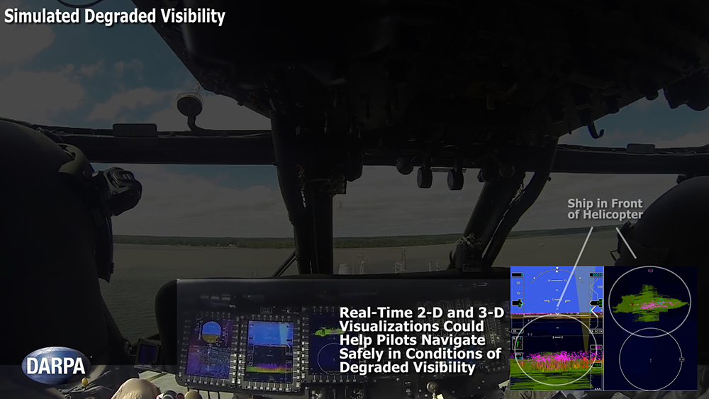
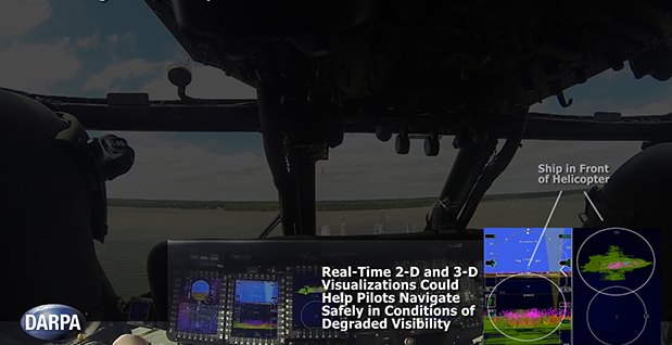
    MFRF completed successful flight demonstrations on a UH-60L Black Hawk combat helicopter (see video above) to demonstrate the Synthetic Vision Avionics Backbone (SVAB) technology portion of the program. The SVAB technology demonstration fused millimeter-wave radar with multiple terrain databases and onboard platform navigation to create high-resolution 2D and 3D visualizations of local environmental conditions.

    Pilots referred to the visualizations in real time to distinguish terrain features (slope, roughness, landing suitability), detect objects in a landing zone, detect and avoid obstacles, and navigate in GPS-denied conditions. The software architecture of the SVAB also demonstrated plug-and-play sensor control and display.

    “These successful tests take us closer to future cost-effective, ‘plug-and-play’ systems that would improve situational awareness and mission effectiveness for manned and unmanned platforms alike,” said Bruce Wallace, DARPA program manager.

    DARPA-helicopter_RF-W
    Photo: DARPA


  • Juniper Systems, Effigis Provide Sub-Meter GPS Accuracy

    Juniper Systems, Effigis Provide Sub-Meter GPS Accuracy

    The Juniper Archer 2. Photo: Juniper Systems
    The Juniper Archer 2. Photo: Juniper Systems

    Rugged handheld manufacturer Juniper Systems and Effigis, a geomatics solutions provider, have partnered to provide a powerful solution to capture and post-process GPS data to attain sub-meter accuracy.

    Effigis’ OnPOZ Precision Positioning Software suite takes advantage of the superior GNSS performance of Juniper Systems’ Archer 2 rugged handheld to collect high-accuracy GPS data. First, EZTag CE software is used on the Archer 2 to capture GPS field data points. The data is then sent to a desktop computer, where EZSurv Post-Processing Software automatically post-processes the data to achieve results with sub-meter accuracy. EZSurv removes the hassle of post-processing, requiring the click of a button to run, the companies said.

    Juniper Systems’ Archer 2 is ruggedized, enabling it to perform well as a data-collection tool in any environment, while the enhanced GNSS receiver provides a reliable signal, even in heavy tree canopy.

    “Achieving sub-meter GPS accuracy typically has two barriers in people’s minds. One, the hardware and software are usually expensive. And two, the thought of post-processing makes a lot of people cringe. The OnPOZ suite, on the other hand, is powerful, yet comes at a price people are comfortable with, and it takes care of all the post-processing for you,” said Jim Benson, Utilities & Public Services Market Manager at Juniper Systems. “The Archer 2 handheld really finishes off the whole package. Its GNSS receiver is outstanding, performing reliably even under trees, and the handheld is so well designed, you can count on it to work well in any environment.”

    To learn more about the Archer 2 and OnPOZ Precision Positioning Software suite, download the brochure.

  • Satlab Geosolutions Adds Americas Office, Appoints Phil Gabriel

    Satlab Geosolutions Adds Americas Office, Appoints Phil Gabriel

    Satlab products include (from left) the SL600 6G GNSS receiver, the SL300 6G GNSS receiver, and the SL55 controller. Photo: Satlab Geosolutions AB
    Satlab products include (from left) the SL600 6G GNSS receiver, the SL300 6G GNSS receiver, and the SL55 controller. Photo: Satlab Geosolutions AB

    Swedish-based survey and GIS equipment maker Satlab Geosolutions AB has expanded into the U.S. and Americas with the creation of a new sister company Satlab Geosolutions (USA), Inc., based in Scottsdale, Arizona. Phil Gabriel has been named managing director of the USA office.

    Setting up a formal base of operations in the U.S. will allow Satlab to better service their clients and expand their customer base in the U.S., Canada, Mexico and Latin America, a company release said. As past president of Hemisphere GNSS, Gabriel brings to the team his many years of experience in the survey, GIS, GNSS, machine control, marine and navigation industries, Satlab said.

    The U.S. location will sell, support and service the new product lineup being introduced at InterGeo in Berlin, Germany, on October 7.  Satlab is seeking dealers to expand its business throughout the Americas.

    “The addition of a U.S. office is an exciting next step for us, after successful expansion into Turkey and the Czech Republic in the last few years,” said Bjorn Agardh, CEO of Satlab Geosolutions AB.

    “Our products have been well received and continue to perform extremely well,” added Birol Gucluer, CTO and partner of Satlab.

    “I’m excited to join Bjorn and Birol, extending their success by ensuring their high standards in customer service are maintained here in the Americas,” Gabriel said.

    Satlab invites Survey and GIS dealers to meet the expanded team at InterGeo October 7-9 in Berlin, where they will be introducing several new models of their popular receivers and handhelds.

  • ION GNSS+ 2014: Exelis Inc.

    Lori Thompson with Exelis Inc. gives updates about the company at the 2014 ION GNSS+ Conference September 9-12 in Tampa, Florida. The company is celebrating more than 700 years of on-orbit performance.

  • ION GNSS+ 2014: Rohde & Schwarz

    Darren McCarthy, Rohde & Schwarz, gives GPS World a booth tour of its GNSS solutions, avionics gear and interference hunting solutions while at the 2014 ION GNSS+ Conference, held September 9-12 in Tampa, Florida.

  • u-blox SARA-U260 Module Receives AT&T Approval

    u-blox SARA-U260 Module Receives AT&T Approval

    The u-blox SARA-U260 module.
    The u-blox SARA-U260 module. Photo: Swiss u-box

    Swiss u‑blox says that its SARA-U260 dual-band 3G/2G module has achieved AT&T network compatible status.

    The certification allows customers to design SARA-U260 modems into M2M devices operating over AT&T’s extensive 3G network in the USA. Typical applications include small tracking boxes, usage-based insurance devices, smart metering, wearable electronics, and connected fitness watches.

    SARA-U260 is a complete 3G/2G voice/data module for applications that still require roaming ability with 2G using AT&T’s extensive 3G network coverage. The SARA-U260 provides full voice and data capability as well as a full suite of IP protocol stacks. The module features have been selected to give customers specific features they need for telematics units, handheld devices, communications modules, point-of-sale terminals, vehicle “black boxes,” and utility meters.

    SARA-U260 provides efficient and cost-effective mobile connectivity in a miniature 16 x 26 mm2 LGA form factor. The module is pin-compatible with SARA-G3 GSM/GPRS modules, as well as layout-compatible with LISA-U2 (HSPA) and TOBY-L2LTE modules to support future-proof 4G LTE designs.

    All SARA modules share the same form-factor and footprint and are designed based on u-blox’ “nested design” philosophy. This allows engineers to develop one hardware/software platform to support GSM/GPRS, HSPA, or LTE, depending on their end customer requirements.

    SARA-U260 hosts multiple embedded IP protocols, such as TCP/IP, UDP/IP, HTTP, and FTP. In-band modem support for automotive emergency calls like eCall and ERA/GLONASS are also integrated. With extremely low-power consumption, the SARA-U260 is designed for battery-powered and handheld devices.

    With direct A-GPS support for accelerated positioning and u-blox’ CellLocate hybrid positioning technology, SARA-U260 is designed to match u-blox advanced GNSS positioning capabilities, including indoor positioning.

    “u-blox is proud that AT&T certified our SARA-U260 module for its network,” said Nikolaos Papadopoulos, president of u-blox America. “Our robust voice and data modules deliver powerful 3G connectivity with 2G fallback in the smallest package on the market, at a price that customers recently paid for a 2G module.”

    For Europe and Asia, u-blox also offers the pin- and software compatible certified version SARA-U270.

    RIL software for Android and Embedded Windows is available free of charge from u-blox.

  • ION GNSS+ 2014: IFEN Inc.

    Mark Wilson, IFEN Inc., demonstrates the company’s new XS3 software receiver – which succeeds the scientific GNSS software-receiver SX-NSR – at the the 2014 ION GNSS+ Conference September 9-12 in Tampa, Florida.

  • North Korea Developing Precision-Guided Bomb

    North Korea is developing a GLONASS precision-guided bomb similar to the GPS-guided joint direct attack munitions (JDAMs) of the United States, reports South Korean newspaper The Chosun Ilbo (Korea Daily). 

    “We expect that the North will finish development of a new precision-guided bomb in the near future because we’ve detected signs that the North has been conducting tests for a few years now,” a military source in South Korea told the newspaper.

    The JDAM GPS-guided bomb has a range of 28 kilometers and accuracy of about 13 meters. North Korea’s new bomb is believed to have a range of 10 kilometers.

    According to The Chosun Ilbo, military authorities say they detected signs of a fighter jet dropping the bomb over a testing ground in North Korea’s Hwanghae Province earlier this year.

    The South Korean Air Force has a variety of precision bombs, including a device with a range of 100 kilometers.

    The JDAM kit is at the tail of the munition.
    The JDAM kit is at the tail of the munition.
  • IRNSS Signal in Space ICD Released

    News courtesy of CANSPACE Listserv.

    IRNSS_ICD_Cover-W
    Photo: CANSPACE Listserv

    The Indian Space Research Organization (ISRO) has released Version 1 of the Indian Regional Navigational Satellite System (IRNSS) Signal in Space Interface Control Document for the Standard Positioning Service.

    The document provides information on the signals and structures of the IRNSS system, including signal modulations, frequency bands, received power levels, the data structures and their interpretations, and user algorithms.

    According to ISRO, the document is being released to the public to facilitate research and development and to aid the commercial use of the IRNSS signals for navigation-based applications.

    Registration is required for ICD download access at a new IRNSS website. At the moment, only the ICD is available at this website.

    The next IRNSS satellite launch is scheduled for the second week of October. The most recent launch was in April, of the second IRNSS satellite, IRNSS-1B.

    IRNSS is an independent regional navigation satellite system being developed by India. It is designed to provide accurate position information service to users in India and the region extending up to 1,500 kilometers from its boundary. IRNSS will provide two types of service: Standard Positioning Service (SPS) and Restricted Service (RS). It is expected to provide a position accuracy of better than 20 meters in the primary service area.

  • ION GNSS+ 2014: Harxon Corporation

    Qian Haizhong of Harxon Corporation shares on the company’s new product, the Helix antenna, at the 2014 ION GNSS+ Conference September 9-12 in Tampa, Florida.

  • Altus Shipping Latest GNSS RTK Receiver

    Altus Positioning's APS-NR2 RTK receiver.
    Altus Positioning’s APS-NR2 RTK receiver.

    Septentrio subsidiary Altus Positioning Systems is now shipping demo units of its latest GNSS RTK receiver, the APS-NR2. The high-performance receiver incorporates GNSS and wireless technology into a sleek and compact design to provide an intelligent network rover with on-board configuration and extended operation time, the company said.

    Based on a low-power and small-footprint OEM GNSS receiver, the APS-NR2 offers robust RTK while consuming less power for longer operation time on battery power.

    For easy configuration and status monitoring, the APS-NR2 features an on-board web interface accessible via Wi-Fi. This makes the APS-NR2 configurable from any device that has a browser and Wi-Fi, and with any operating system. Real-time data is streamed over Bluetooth for a completely cable-free operation.

    A 3.5G Quad-band GSM/GPRS/EDGE + HSPA cellular modem supports reliable RTK network connectivity with an intelligent reconnect feature. In addition to standard Li-Ion battery chargers and USB cable interface, the design includes on-board USB battery recharge. At 1.5 lbs., the APS-NR2 weighs the same as a dozen glazed doughnuts.

    “It all adds up to the world’s most versatile RTK rover that provides more productivity and less downtime in the field,” said Vancans. “The APS-NR2 raises the bar and sets a new standard for the state-of-the-art in high-precision surveying and geolocation, leveraging the power and convenience of mobile tablet platforms.” Units are expected to ship starting October 20.

  • Unmanned Systems Take Flight at 2015 International CES

    HEXO+, an autonomous flying camera system, by Squadrone Systems will exhibit at CES 2015. Photo: Squadrone Systems
    HEXO+, an autonomous flying camera system, by Squadrone Systems will exhibit at CES 2015. Photo: Squadrone Systems

    The Consumer Electronics Association today announced the debut of the Unmanned Systems Marketplace at the 2015 International Consumer Electronics Show (CES). Owned and produced by CEA, the International CES is a gathering place for those who thrive on the business of consumer technologies. The 2015 CES is scheduled to run January 6-9, 2015, in Las Vegas, Nevada.

    The Unmanned Systems Marketplace highlights the burgeoning technology in drones, unmanned aerial vehicles (UAVs), and other unmanned systems controlled by onboard computers or remotely from the ground. In its first year at the CES, the Unmanned Systems Marketplace is expected to cover 6,500 square feet of exhibit space with room for about 16 high-end commercial and consumer UAV technology companies.

    According to CEA research, the global market for consumer drones will approach $130 million in revenue in 2015, increasing by 55 percent from 2014, with unit sales of consumer drones expected to reach 400,000. The revenue from drone sales is expected to easily exceed $1 billion in just five years.

    “Drones and unmanned systems are being used to assist in a variety of applications, from aerial coverage for sports and real estate, to assistance in search and rescue and disaster relief missions,” said Karen Chupka, senior vice president, International CES and corporate business strategy, CEA. “We’re excited to introduce the Unmanned Systems Marketplace at the 2015 CES and witness how these unique tools are revolutionizing the way we capture and monitor our world.”

    The Unmanned Systems Marketplace will be located at CES Tech East, in the Las Vegas Convention and World Trade Center (LVCC), South Hall 2. Tech East includes the LVCC, the Westgate Las Vegas , and Renaissance Las Vegas. Major exhibitors located within the Unmanned Systems Marketplace include AirDog, Squadrone, Trace, DJI, iRobot, Trace, Torquing Group DBA ZANO, Ecovacs, EHang, Autel, Pelican Products, and other brands.

    The 2015 CES will feature 20 category-specific marketplaces highlighting innovation across diverse product areas. Companies interested in exhibiting in the Unmanned Systems Marketplace should contact Oleg Burdo at [email protected] or 703-907-5257.

    Registration for the 2015 CES is open. For more information on the 2015 CES, visit CESweb.org.