Author: GPS World Staff

  • New Tide Gauge Uses GPS to Measure Sea-Level Change

    New Tide Gauge Uses GPS to Measure Sea-Level Change

    A panorama from the GNSS tide gauge at Onsala Space Observatory. When satellites pass over the sky, the GNSS tide gauge uses signals direct from the satellite and signals reflected off the sea surface to measure the sea level. Photo: Johan Löfgren
    A panorama from the GNSS tide gauge at Onsala Space Observatory. When satellites pass over the sky, the GNSS tide gauge uses signals direct from the satellite and signals reflected off the sea surface to measure the sea level. Photo: Johan Löfgren

    A new way of measuring sea level using satellite navigation system signals, for instance GPS, has been implemented by scientists at Chalmers University of Technology in Sweden. Sea level and its variation can easily be monitored using existing coastal GPS stations, the scientists have shown.

    Measuring sea level is an increasingly important part of climate research, and a rising mean sea level is one of the most tangible consequences of climate change. Researchers at Chalmers University of Technology have studied new ways of measuring sea level that could become important tools for testing climate models and for investigating how the sea level along the world’s coasts is affected by climate change.

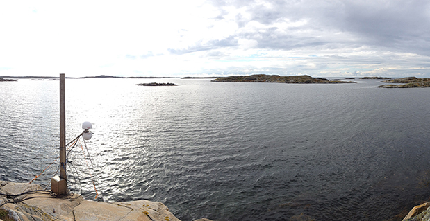
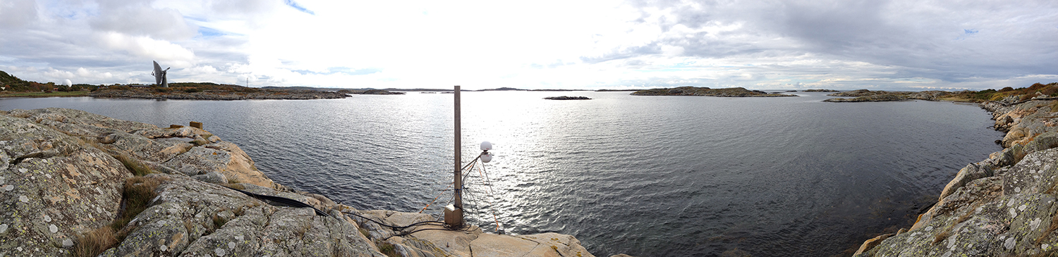
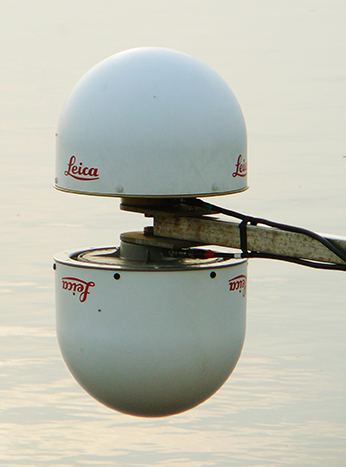
    Johan Löfgren and Rüdiger Haas, scientists at Chalmers Department of Earth and Space Sciences, have developed and tested an instrument that measures the sea level using a GNSS tide gauge.

    ”The global mean sea level is rising because of climate change, but the change depends on where you are in the world,” says Rüdiger Haas. “We want to be able to make detailed measurements of sea level so that we can understand how coastal societies will be affected in the future.”

    When satellites pass over the sky, the GNSS tide gauge uses signals direct from the satellite and signals reflected off the sea surface to measure the sea level. Photo: Johan Löfgren
    When satellites pass over the sky, the GNSS tide gauge uses signals direct from the satellite and signals reflected off the sea surface to measure the sea level. Photo: Johan Löfgren

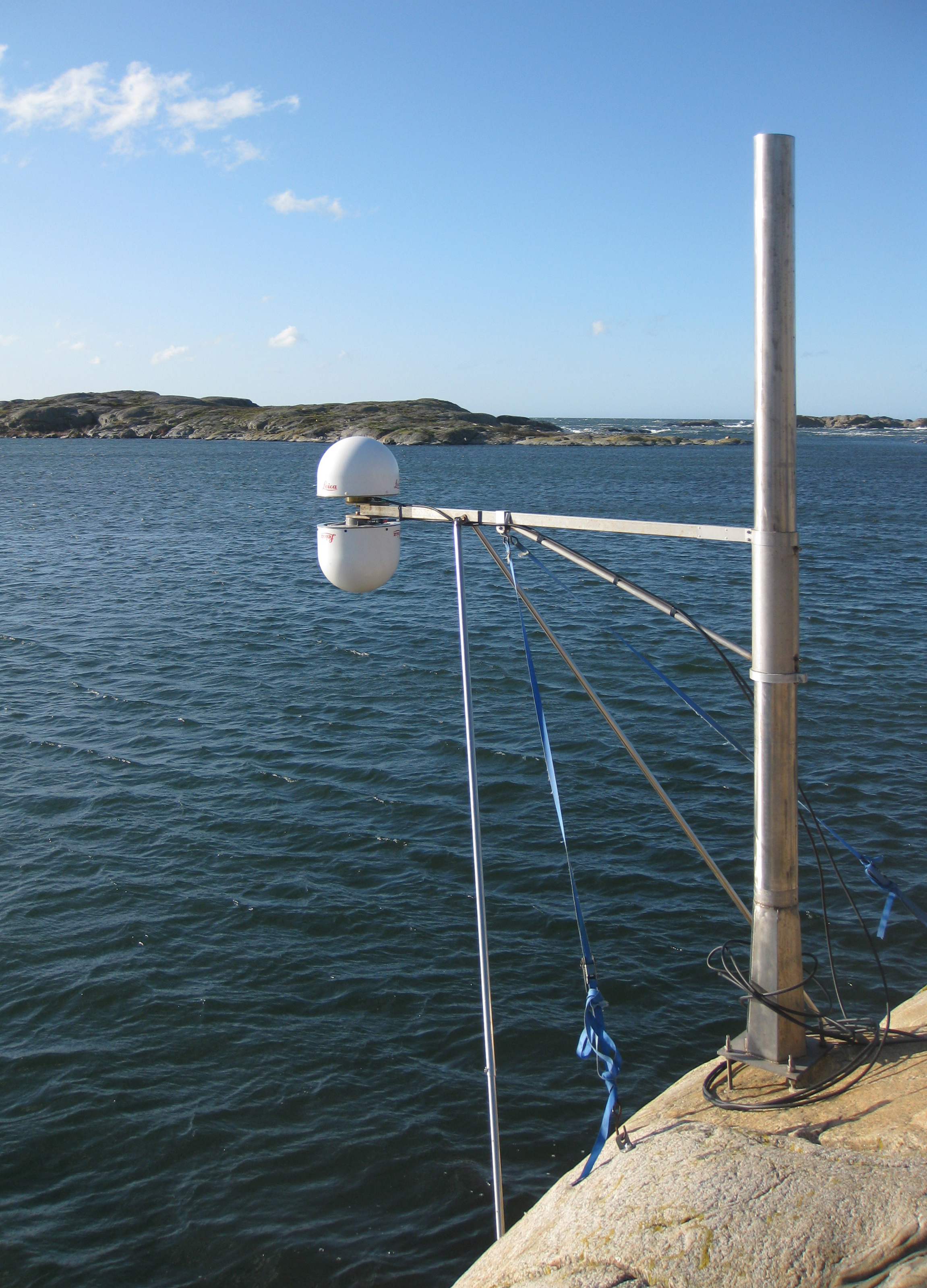
    The GNSS tide gauge uses GPS and GLONASS signals. BeiDou and Galileo will be added in the future.

    ”We measure the sea level using the same radio signals that mobile phones and cars use in their satellite navigation systems,” says Johan Löfgren. “As the satellites pass over the sky, the instrument ‘sees’ their signals — both those that come direct and those that are reflected off the sea surface.”

    Two antennas, covered by small white radomes, measure signals both directly from the satellites and signals reflected off the sea surface. By analyzing these signals together, the sea level and its variation can be measured, up to 20 times per second. The sea level time series is rich in physical phenomena such as tides (caused mostly by the gravitational pull of the Moon and the Sun), meteorological signals (high and low pressure), and signals from climate change. Through advanced signal processing, these signals can be studied further.

    The new GNSS tide gauge can measure changes in both land and sea at the same time, in the same location. That means both long-term and short-term land movements (post-glacial rebound and earthquakes) can be taken into consideration.

    ”Now we can measure the sea level both relative to the coast and relative to the center of the Earth, which means we can clearly tell the difference between changes in the water level and changes in the land,” says Johan Löfgren.

    This summer, other high-precision instruments will be installed to work with the Onsala GNSS tide gauge, in collaboration with SMHI, the Swedish Meteorological and Hydrological Institute.

    The GNSS tide gauge at Onsala Space Observatory uses signals from satellite navigation systems like GPS to measure the sea level. Photo: Johan Löfgren
    The GNSS tide gauge at Onsala Space Observatory uses signals from satellite navigation systems like GPS to measure the sea level. Photo: Johan Löfgren

    ”Our tide gauge station will become part of a network of stations along the coast of Sweden that will be able to monitor changes in the water level to millimeter precision well into the future,” says Gunnar Elgered, professor at Chalmers Department of Earth and Space Sciences.

    The scientists have also shown that existing coastal GNSS stations, installed primarily for the purpose of measuring land movements, can be used to make sea-level measurements.

    ”We’ve successfully tested a method where only one of the antennas is used to receive the radio signals. That means that existing coastal GNSS stations — there are hundreds of them all over the world — can also be used to measure the sea level,” says Johan Löfgren.

    More about the research

    The method is described in two new scientific articles:

    Sea level time series and ocean tide analysis from multipath signals at five GPS sites in different parts of the world

    and Sea level measurements using multi-frequency GPS and GLONASS observations

    This work was previously reported in these publications:

    Larson, K.M., J. Lofgren, and R. Haas, Coastal Sea Level Measurements Using A Single Geodetic GPS Receiver, Adv. Space Res., Vol. 51(8), 1301-1310, 2013, doi:10.1016/j.asr.2012.04.017, 2013.

    Larson, K.M., R. Ray, F. Nievinski, and J. Freymueller, The Accidental Tide Gauge: A Case Study of GPS Reflections from Kachemak Bay, Alaska, IEEE GRSL, Vol 10(5), 1200-1205, doi:10.1109/LGRS.2012.2236075, 2013.

  • Altus Announces Second-Generation GNSS RTK Rover

    Altus Announces Second-Generation GNSS RTK Rover

    The Altus APS-NR2.
    The Altus APS-NR2.

    Altus Positioning Systems has introduced its new APS-NR2 RTK surveying receiver. The new product is being previewed at the 2014 Geo Business conference and exhibition in London May 28-29, and will be commercially available in July.

    “The APS-NR2 provides a powerful combination of high GNSS RTK performance, light weight, low power consumption, versatile Quad-band modem, remote Web-based access and connectivity with Esri’s cloud-based platform,” said Neil Vancans, Altus president and CEO. “The result is a versatile product designed to enhance productivity and minimize downtime in the field for a wide range of surveying and geolocation jobs.”

    The APS-NR2 is Altus’ second-generation RTK rover, building on the highly successful APS-3 product series. It features an easily accessible on-board web interface and integrated Wi-Fi for easy remote configuration and status monitoring, as well as Bluetooth for real-time data streaming, providing true cable-free operation. In parallel to RTK positioning, data can be recorded on a removable 2-GB SD memory card for post-processing.

    The APS-NR2 is built around a low-power 132-channel GPS/GLONASS L1/L2/L2C SBAS receiver, which offers robust RTK performance, as well as DGPS capability. The internal 3.5G Quad-band GSM/GPRS/EDGE cellular modem supports RTK network connectivity. Dual internal cellular antennae ensure a positive signal lock and minimize disruptions due to dropped calls.

    The new Altus receiver comes with two Li-Ion batteries. It has a built-in USB battery charger, as well as a separate two-bay external charger. The batteries are hot-swappable, allowing uninterrupted productivity on the job.

    With Altus’ open-architecture philosophy, the user has a choice of data collector software from Carlson SurvCE, MicroSurvey FIELDGenius or direct interface to Esri ArcGIS Online, as well as proprietary customer-developed software.

    The APS-NR2 doesn’t sacrifice essential processing power or connectivity and still weighs only 0.7 kg (1.5 lbs). The compact receiver is just 69 mm (2.7 in) high and 167 mm (6.6 in) in diameter. The rugged unit is waterproof to IP67 and has an operating temperature range of -40 to +85°C.

  • Photos: GEO Business 2014 in London

    GPS World Publisher Steve Copley is attending GEO Business 2014, where GPS World is a sponsor. The show is being held in London this week. He’s been tweeting from the show. Follow his tweets here, and GPS World’s Twitter account here.

    GEO Business 2014 is a new geospatial event for everyone involved in the gathering storing, processing and delivering of geospatial information. It is organized in collaboration with The Chartered Institution of Civil Engineering Surveyors (ICES), The Association for Geographic Information (AGI), The Royal Institution of Chartered Surveyors (RICS) and The Survey Association (TSA).

  • McMurdo Group Completes Acquisition of Techno-Sciences

    McMurdo Group, an end-to-end search and rescue (SAR) and maritime domain awareness (MDA) company, has acquired Techno-Sciences, Inc. (TSi), a provider of SAR satellite ground stations, integrated emergency response center systems and coastal surveillance solutions. Terms of the acquisition were not disclosed. TSi’s Beltsville, Maryland, location becomes the U.S. headquarters for McMurdo Group, a division of Orolia, global specialist in critical GNSS solutions.

    TSi has been instrumental in the development of the COSPAS-SARSAT international satellite-based SAR program, which has helped to save more than 35,000 lives worldwide since 1982. TSi is also actively involved in the next-generation COSPAS-SARSAT system, MEOSAR (Medium Earth Orbit Search and Rescue), which will greatly improve the existing SAR process with near-instantaneous detection, identification and location of emergency distress beacons.

    MEOSAR, currently in its demonstration and evaluation phase, is expected to have initial operational capability in 2016 and full operational capability by 2018. MEOSAR will use SAR-enhanced Galileo (Europe), GPS (U.S.) and GLONASS (Russia) satellite constellations for greater global coverage and includes innovative end-user beacon functionality such as a return-link service on Galileo satellites to acknowledge distress signal receipt and provide ongoing rescue effort status.

    “The acquisition of TSi firmly establishes McMurdo Group as the global leader in satellite-based search and rescue solutions. We are the only provider capable of supplying a single-vendor, end-to-end COSPAS-SARSAT emergency solution with a seamless ecosystem of products, technologies and processes that will streamline and expedite search and rescue efforts,” said Jean-Yves Courtois, CEO, McMurdo Group and its holding company Orolia Group. “TSi expands our global sales, support and customer footprint and adds to our already extensive expertise in SAR and MDA. We look forward to developing a U.S. SAR Center of Excellence to include manufacturing, distribution and support of McMurdo Group’s broad solution offering of distress beacons, AIS equipment, satellite communications units and emergency control centers equipped with search and rescue management software.”

    TSi solutions are installed in more than 20 countries worldwide and include satellite ground stations or local user terminals (LUTs), rescue and mission control centers, and coastal surveillance/instruction detection systems. TSi installed the world’s first operationally ready six-channel MEOSAR LUT (MEOLUT) in 2011 for the U.S. National Oceanic and Atmospheric Administration (NOAA) and has recently completed a second NOAA installation (March 2014). With a team of 40 employees, TSi has a prominent list of government, military and commercial customers in Asia, Europe, Africa and the U.S. (including NOAA, NASA and the U.S. Navy).


  • Watch out for Falling Coconuts — with GPS

    Port Douglas, Queensland, Australia, is looking to reduce any potential deaths from falling coconuts, reports ABC News.

    The Douglas shire council is mapping the GPS locations of its coconut trees, to reduce the danger. Mayor Julia Leu says more than 4,000 mature coconut palms have been identified in Port Douglas.

    “All local governments that have coconut palms in their area do have a de-nutting program. However the de-nutting process is very costly,” Leu said. “What we want to do is look at this in a far more innovative way.”

    On average, 150 people die annually around the world from falling coconuts.

  • Test Shows Galileo Increases Accuracy of Location-Based Services

    The European GNSS Agency (GSA) and Rx Networks Inc., a mobile location technology and services company, announced the results of tests conducted by the company measuring the performance of Galileo when used in various combinations with GPS and GLONASS.

    Tests were conducted in real-world environments, including urban canyons and indoors. These environments pose significant challenges to location accuracy due to multipath and obstructed views of satellites. Each test consisted of a three-hour data capture of GNSS signals, which was later replayed to produce hundreds of fixes using a multi-constellation GNSS receiver from STMicroelectronics.

    The results showed that using Galileo with one or more other GNSS constellations provides significantly more accurate location fixes compared to GPS alone, when indoors or in urban canyons. As expected, the GPS+Galileo combination did not exceed the performance of GPS+GLONASS, due primarily to there only being four Galileo satellites available at the time of the testing. It is expected that, as more Galileo satellites are launched, the combination of Galileo with GPS will show further improvements in performance, GSA and RX Networks said.

    According to Gian-Gherado Calini, head of Market Development at the GSA, “Dual-constellation GNSS designs are the standard for many smartphones and other devices. The combination of GPS and Galileo provides a robust solution and is expected to offer performance that will meet or exceed end-user expectations.”

    “The results should be encouraging to any GNSS chipset manufacturer who is considering adding Galileo as a competitive differentiator,” said Adrian Stimpson, senior vice president of Sales and Marketing, Rx Networks.

    Test Results

    Recent test results confirm that Galileo significantly improves accuracy in challenging environments:

    GSA-Positive-Test-Results-27-May

    The tables above show the summary results for various scenarios and constellation combinations. The GPS row shows the absolute 2D errors in meters. All other rows show the improvement (+) or degradation (-) in meters and percentages relative to GPS-only fixes. All measurements are within the 95th percentile.

  • Globecomm Receives Contract Extension from NATO for GPS-Based Tracking

    Globecomm, a global provider of communications solutions and services, has received a contract extension from NATO Communications and Information Agency (NCI Agency) valued at $9.6 million to extend communication services and onsite support for the company’s previously deployed GPS-Based Force Tracking System (FTS).

    The FTS provides NATO with high levels of tracking data and messaging traffic. It enables NATO to identify where its personnel are located at all times, identify other multinational forces, and have the ability to do so in routine and operational situations. This is critical in assisting with the identification of friendly forces and helps prevent “blue-on-blue” incidents, the company said.

    Globecomm previously announced approximately $74.7 million in contracts from NATO for this project to design and install a GPS FTS, bringing the combined contract value to approximately $84 million.

    “Globecomm is pleased to receive this contract extension to continue to deliver this important service,” said Paul Knudsen, vice president of Globecomm’s Eastern Atlantic Team. “We completed an upgrade of this system last year under a separate contract that was previously announced. Globecomm has been providing this service since 2007.”

  • Geoforce Releases Tiny Industrial GPS Tracking Device

    Geoforce, Inc., an international provider of asset management solutions for the oil and gas industry, has announced the widespread commercial availability of the GT0, a tiny industrial GPS asset-tracking device. The device is designed to track and remotely monitor assets too challenging for other GPS devices, the company said.

    “Geoforce is constantly trying to gauge what our customers will need next,” said James MacLean III, Geoforce’s president and CEO. “What we’ve been hearing out there is this: smaller, easier and whenever possible — more affordable. We’ve purpose-built this device to try and meet those needs without dropping the quality-level our customers deserve.”

    The GT0 has a powerful omni-directional antenna, allowing for placement in almost any orientation on an asset. The tracking device is engineered with RFID and GPS technology for location and identification, as well as QR coding for mobile scanning of product information. Its compact size allows the tag to fit on equipment where previous larger and bulkier asset-tracking devices could not be implemented. It is an IP67 device (weatherproof) and has an optional metal bezel for added protection. It has an expected five to seven year battery life, making it a simple-to-deploy “slap and track” device.

    More than 300 companies currently use Geoforce’s solutions to manage 100,000 assets across six continents. The GT0 was previously offered in limited release to several service and rental companies beginning in January of this year.

  • Trimble Introduces Compact OEM GNSS UHF Receiver Module for High-Accuracy Positioning

    Trimble Introduces Compact OEM GNSS UHF Receiver Module for High-Accuracy Positioning

    The Trimble BD930-UHF high-performance integrated UHF receiver.
    The Trimble BD930-UHF high-performance integrated UHF receiver.

    Trimble has introduced the Trimble BD930-UHF receiver and communication module. As part of Trimble’s GNSS OEM portfolio, the new compact module features centimeter-level, Real-Time Kinematic (RTK) positioning capabilities coupled with an integrated UHF receiver for precise mobile positioning. The BD930-UHF module’s connectivity and configuration capabilities allow system integrators and OEMs to easily add GNSS, centimeter-level positioning to specialized or custom hardware solutions.

    “The OEM and system integrator communities demand high performance, reliability and support for their positioning solutions,” said Dale Hermann, general manager of the Integrated Technologies division at Trimble. “The Trimble BD930-UHF delivers the latest GNSS and communication technology in an easy-to-integrate form factor for demanding conditions and applications such as field computing, port automation and lightweight robotic or unmanned vehicles. With the BD930-UHF module, customers are purchasing a solution not just a GNSS receiver.”

    Taking advantage of Trimble’s expertise in both GNSS and UHF communications, the Trimble BD930-UHF module has been designed for applications requiring centimeter accuracy in a compact package. By integrating wireless communications on the same module, the task of receiving RTK corrections is significantly simplified.

    The triple-frequency GPS/GLONASS/BeiDou/Galileo BD930-UHF provides customers with a multi-constellation solution that can reduce their integration effort and time to market. Ethernet connectivity and onboard web server allows high-speed data transfer and configuration via standard browsers. USB and RS232 ports are also supported. By tightly integrating communications with the GNSS receiver, integrators can reduce costs, power, weight and size.

    The Trimble BD930-UHF is expected to be available in July 2014 through Trimble’s Precision GNSS + Inertial sales channel worldwide.

  • Raytheon’s VIIRS View App Provides World Weather to Mobile Users

    Raytheon’s VIIRS View App Provides World Weather to Mobile Users

    Raytheon-VIIRS

    Available for iPhone, iPad and Android, VIIRS View provides mobile device users a look into the type of data meteorologists and climatologists use every day to track the weather and monitor Earth’s environment.

    Based on data generated by the Visible Infrared Imaging Radiometer Suite aboard Suomi NPP, VIIRS View combines visible light imagery, low-light nighttime imagery and ocean chlorophyll concentration onto a full Earth globe, rotatable and zoomable on any location on the planet.

    A desktop version of the VIIRS View app, launched in February, has been downloaded more than 90,000 times.

    An original large format VIIRS View interactive tabletop display is being shown at Raytheon Booth #203 at the the 30th Space Symposium, being held this week in Colorado Springs, Colorado. GPS World Defense Editor Don Jewell is providing coverage from the symposium.

    The app can be downloaded by searching VIIRS View at the Google Play and Android stores, or by clicking here:

    Google

    Apple:
    VIIRS iPhone
    VIIRS iPad

  • Space Foundation Report Shows Growth in Global Space Economy

    The global space economy grew to $314.17 billion in commercial revenue and government budgets in 2013, reflecting growth of 4 percent from the 2012 total of $302.22 billion, according to The Space Report 2014. The report was issued this week by the Space Foundation during the 30th Space Symposium being held this week in Colorado Springs, Colorado. GPS World Defense Editor Don Jewell is providing coverage from the symposium.

    Commercial activity — space products and services and commercial infrastructure — drove much of the increase. From 2008 through 2013, the total has grown by 27 percent. Commercial space products and services revenue increased 7 percent since 2012, and commercial infrastructure and support industries increased by 4.6 percent.

    Government spending decreased by 1.7 percent in 2013, although changes varied significantly from country to country. Substantial space budget cuts in the United States outweighed gains in Canada, India, Russia, South Korea, and the United Kingdom, all of which increased budgets by 25 percent or more.

    These new global space economic numbers come from the Space Foundation’s publication, The Space Report 2014:The Authoritative Guide to Global Space Activity, which was released today. Data was compiled from original research and a wide variety of public and private sources, and analyzed by Space Foundation researchers.

    Key Findings

    The 160-page book contains worldwide space facts and figures and is illustrated with photographs, charts and graphs. Within are myriad examples of the benefits of space exploration and utilization, the challenges facing the space sector, the opportunities for future growth and the major factors that shape the industry. In addition, The Space Report includes an overview of each sector, definitions, and up-to-date information on space infrastructure, facilities, launches and programs.

    Following are just some of the many interesting facts and analyses found in The Space Report 2014: The Authoritative Guide to Global Space Activity:

    Launches and Satellites

    • 81 launch attempts took place in 2013, an increase of 4 percent from the 78 launches in 2012 (and above the five-year average of 79 launches per year).
    • The majority of these launches were conducted by Russia (32 launches), the United States (19), China (15), and Europe (7).
    • After two years of conducting fewer launches than China, the United States rose again to second place, partly due to an increased operational tempo as U.S. commercial providers launched cargo resupply missions to the International Space Station.
    • New launch vehicles made their first flights (or first successful flights) in five countries–the Antares and Minotaur V in the United States, Soyuz 2.1v in Russia, Kuaizhou in China, Epsilon in Japan, and KSLV-1 (also called Naro-1) in Korea.
    • The number of satellites launched during 2013 increased by nearly two-thirds compared to 2012. This was largely due to a significant uptick in the number of satellites with masses below 91 kilograms (200 pounds). These microsatellites constituted more than half of the 197 satellites launched in 2013.
    • Many of the microsatellites were short-lived technology demonstrations, but there is a considerable degree of interest in future possibilities for constellations of small satellites that provide valuable services on an ongoing basis.


    Workforce

    According to U.S. Bureau of Labor Statistics (BLS) data, the size of the U.S. space workforce declined for the sixth year in a row, dropping 3.5 percent, from 242,724 in 2011 to 234,173 in 2012 (the most recent full year for which data is available) – a decrease of about 8,500 workers. However, the changes varied by sector, with some portions of the space industry growing while others contracted.

    The United States’ National Aeronautics and Space Administration (NASA)’s civil servant workforce remained essentially flat, declining by less than 1 percent to reach 18,068 in FY 2014. Although the workforce continues to become more concentrated at higher ages, NASA has experienced moderate success in recruiting and retaining young workers below the age of 35 during the past five years.

    Both Europe and Japan saw increases in space workforces; the European industry workforce grew by 1.5 percent in 2012, adding approximately 500 employees; in Japan, the overall workforce grew by 11 percent, while employment at the Japan Aerospace Exploration Agency (JAXA), Japan’s government space agency, dropped.

    The Space Foundation Index

    As of December 2013, the Space Foundation Index was 94.22 percent above its value at inception in June 2005. The Space Foundation Infrastructure Index outperformed the S&P 500 and the NASDAQ during 2013, while the main Space Foundation Index and Space Foundation Services Index did not perform as well as the NASDAQ, but substantially better than the S&P 500. These indexes, which are updated daily on the Space Foundation website, are easy-to-understand mechanisms for gauging the financial performance of space industry companies listed on U.S. stock exchanges.

    The Space Report is published annually by the Space Foundation, which works with a leading aerospace consulting firm, Futron Corporation, to research and analyze government and industry trends in space activity. The stock market analysis is provided by ISDR Consulting, LLC, a management consulting firm specializing in the space, satellite and technology sectors.

  • GPS Developers, Manufacturers Highlighted in New Report

    Plimsoll Publishing is offering a new analysis, “GPS System Developers & Manufacturers,” which provides a detailed overview of the global market and delivers a comprehensive individual analysis on the top 100 companies, including Braemac (CA) LLC, Furuno Electric Co. Ltd. and Harman International Industries, Inc.

    The report includes a wealth of information on the financial trends over the past four years. The analysis is aimed at anyone wanting to:

    • See the market leaders
    • Identify companies heading for failure
    • Seek out the most attractive acquisition
    • Analyze industry trends
    • Benchmark their own financial performance

    Eighteen companies have a declining Plimsoll financial rating, while 12 have shown good sales growth. Each of the largest 100 companies is meticulously scrutinized in a one-page individual assessment and is analyzed using up-to-date and current financial data.

    Every business is examined on the following features:

    • The Plimsoll Chart: A graphical assessment of a company’s financial performance
    • Four-year assessment of the profit/loss and balance sheet
    • A written summary highlighting key performance issues

    The analysis is available for purchase on the Research & Markets website.