On June 2, GPS World reported that GPS tracking stations co-sponsored by U.S. interests but located in Russia had stopped making their data available to scientists and others.
Now, “It looks like the tap has been turned back on, at least at slow flow,” reports Richard Langley, GPS World Innovation editor and University of New Brunswick professor. “Hourly and daily data files from the affected stations are once again being sent to IGS data archive centres. Grigory Steblov of the Geophysical Survey of the Russian Academy of Sciences has reported that ‘the transmission of the data from NEDA [North Eurasian Deformation Array] GPS sites [had] been temporarily suspended due to technical reasons.’
Now, after reorganization, the data flow is being resumed on hourly basis.”
Langley stresses, however, that the real-time flow of data from the NEDA stations has not been turned back on, which is important for some applications.
Ethertronics has unveiled EtherHelix GPS, a small, stand-alone, Right Hand Circularly Polarized (RHCP) external GPS antenna. Measuring 35 mm in length, the EtherHelix GPS is 27 percent shorter than other antennas on the market with no performance trade-offs, the company said. It is designed for high-performance, mission-critical devices such as walkie-talkies, tough books, tough tablets, first responders, public safety, military applications and more.
EtherHelix can be tuned for various satcom frequencies and various polarizations (RHCP or LHCP). EtherHelix GPS is designed using Ethertronics’ patented Isolated Magnetic Dipole (IMD) technology providing high performance and efficiency in a small form factor.
EtherHelix GPS has a high tolerance to frequency shifts given the technology’s high RF isolation, which is designed to resist antenna detuning that can otherwise impair reception. EtherHelix GPS provides exceptional coverage inside buildings, vehicles or other areas where weak signals and signal reflection occur, the company said.
“GPS capabilities are critical for first responders and military applications. It is imperative that the antennas used in these devices are high-performance, small and rugged,” said Olivier Robin, general manager Americas and Europe at Ethertronics. “EtherHelix GPS is the most recent example of Ethertronics’ leadership in developing industry-first RF solutions to provide manufacturers with a way to differentiate their products and stand out in a competitive market. Already we have seen interest in our new EtherHelix GPS antenna given its best-in-class performance coupled with its smallest occupied volume.”
Given its reduced weight and size — 11.8 g and 35 mm long by 15 mm in diameter — manufacturers benefit from simpler integration for an array of GPS devices, Ethertronics said. In addition, the new GPS antenna’s capabilities include high selectivity, which minimizes the need for additional filters. EtherHelix GPS’s ruggedized design includes IP-68 protection from dust and water, as well as a standard SMA male connector for easy integration. The RoHS Compliant antenna is designed and manufactured in the United States.
EtherHelix GPS is commercially available now and is the first in a series of antennas for mission-critical applications.
Flying for GPS, a chronicle of Len Jacobson’s role in the development and promotion of the Global Positioning System, has just been published.
The book spans a 50-year career, during which Jacobson flew 2½ million miles as a missionary for GPS and as a developer of user equipment. He kept an extensive log of all of his flights, and it enabled him to recreate in his book much of what happened with GPS during his career, and his impressions of why these events occurred.
Flying for GPS covers the user-equipment evolution from expensive, complex and voluminous military sets to today’s low-cost chips buried in our cell phones. It traces a system designed primarily for military and civilian aircraft, ships, and land vehicles to an essential utility of everyday life, enabling new businesses, more safety, and the ability to track everything that moves. It is also a memoir written for the GPS community.
Flying for GPS draws from Jacobson’s GPS experience while working for Hughes Aircraft, Magnavox, Interstate Electronics (IEC), and his own company, Global Systems and Marketing, Inc.
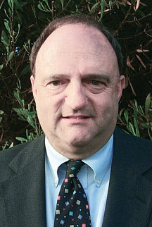
Len Jacobson.
He worked on various assignments from most of the major GPS companies and several small businesses that were trying to find a position in the GPS market. He also participated as an expert witness in many legal cases involving GPS, from patent disputes to accident reconstruction to parolee tracking.
In parallel with the evolution of GPS, the book chronicles the changes in commercial air travel as Jacobson experienced it, from flying on a PanAm 707 in 1963 to an Air France A380 today. The book is available now from www.xlibris.com, Amazon, Barnes & Noble, and soon from ebook outlets.
Len Jacobson is a retired GPS consultant, having worked in the field since 1968. He is still active in the Institute of Navigation, for which he served as western regional vice president twice and held leadership roles in several of its conferences. He lives in Long Beach, California. Visit his site at www.lenjacobson.com.
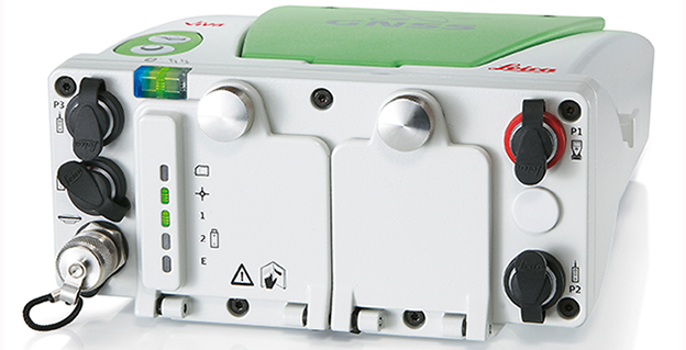
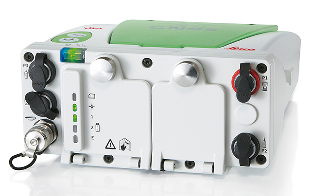
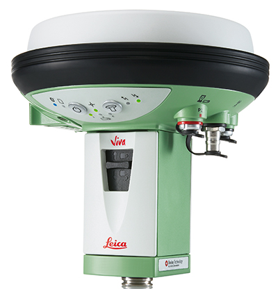
The Leica Viva GNSS Unlimited Series, available in August, will allow customers to make a safe investment with future-proof GNSS receivers and smart antennas, Leica Geosystems said in announcing the new series. With a flexible design, the Viva GNSS sensors can be upgraded for maximum performance whenever needed.
The Leica Viva GNSS range fully supports the Chinese BeiDou navigation system. It can even provide BeiDou-only and GLONASS-only high-precision positioning. The unlimited series includes a future upgrade to a GNSS board with more than 500 channels and will serve users’ needs beyond 2020, the company said. Outages of real-time kinematic (RTK) communication links are bridged for up to 10 minutes with SmartLink to increase centimeter position availability in areas where RTK communications links are unstable.
Leica Viva GS15
The Leica Viva GNSS Unlimited Series can be upgraded to the full range of GNSS signals. The sensors’ future-proof design is equipped for GNSS modernization, providing users with confidence in their investment. The series embraces the future-proof concept by including an upgrade to a GNSS board with more than 500 channels. To fully guarantee future proof GNSS, board exchanges are inevitable because any likely modifications in GNSS signals require a new GNSS ASIC (Application Specific Integrated Circuit).
Leica SmartTrack technology guarantees accurate signal tracking, while SmartCheck technology evaluates and verifies RTK measurements to ensure reliable results. Both SmartTrack and SmartCheck technologies have been extended to support the BeiDou GNSS. BeiDou reached full operational regional capability in 2012 and has a total of 14 satellites. Leica Viva GNSS also supports features like BeiDou-only and GLONASS-only positioning to accommodate governmental regulations.
In addition, Leica Geosystems now offers SmartLink, a correction service delivered via satellite for uninterrupted centimeter positioning in areas where RTK communication links are unstable.
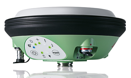
Leica Viva GS14
All Leica Viva GNSS products exceed the toughest environmental specifications, going beyond industrial standards such as IP68. This ensures flawless performance even in the most challenging environments. Applications for the range include construction and field surveying, mining, seismic work in dense forest, desert or mountains, as well as demanding work in extreme heat at 65°C (149 °F) or at extreme latitudes at -30°C (-22 °F). Premium precision and attention to detail ensure that the Leica Viva GNSS products can be trusted throughout the complete product lifetime.
Leica Viva offers a complete range of unlimited GNSS and TPS solutions made with Swiss precision, combining the highest accuracy with maximum versatility and optimized data flow. Leica Viva solutions include Active Customer Care (ACC) with an expansive organization of knowledgeable professionals to provide valuable support, training and service whenever needed. Combined with innovative services such as online support in the field with Leica Active Assist and an instant data exchange between field and office with Leica Exchange, Leica Viva enables continuous productivity.
Webinar on Multi-GNSS OEM
Thursday, June 5 10 a.m. PT / 1 p.m. ET / 5 p.m. GMT
GPS World’s upcoming webinar features an expert panel with informed viewpoints from GNSS high-precision and mass-market manufacturing, signal simulation, and alternative PNT providers. Registration is free.
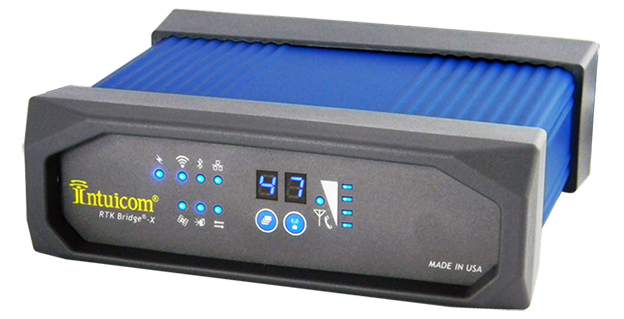
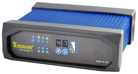
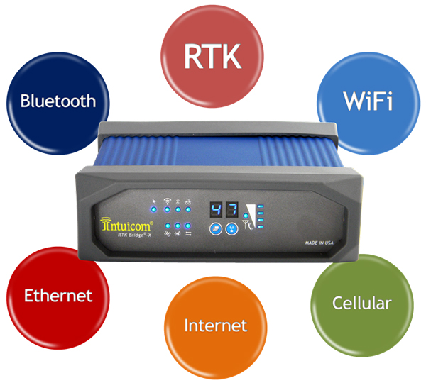
Intuicom, Inc., a wireless data solutions provider for the survey, machine control and precision agriculture industries, has added to its line of RTK Bridge solutions with the Intuicom RTK Bridge-X.
Along with providing reliable access to RTK corrections, the RTK Bridge-X features a Wi-Fi hotspot. Users can connect other Wi-Fi devices such as laptops, tablets and smartphones and access the Internet via the RTK Bridge-X’s cellular connection. Also new with the RTK Bridge-X is cable-free configuration. Configuration can now be accomplished through a wireless connection using any web browser.
Users can then access email, send files, and perform other Internet-based tasks using the connection provided by the RTK Bridge-X. With new Remote Access, the RTK Bridge-X can be reached over the Internet from anywhere.
The RTK Bridge-X also comes with internal GPS. Users can choose between an internal license-free 900-MHz radio, industry-standard UHF radio, or no radio.
Other improvements include a real-time cellular signal strength indicator on the re-designed front panel, as well as an Ethernet port that can be used for configuration or Internet connectivity. A numerical LED display now shows which of the four configurable profiles is active as well as which radio channel is selected. Bluetooth connections are also supported.
Like all Intuicom Bridge Products, The RTK Bridge-X is designed for easy setup and operation and is compatible with all major cellular carriers and equipment manufacturers including Leica Geosystems, Trimble, and others.
A new report from Research and Markets Ltd. forecasts intelligent transport systems, with a focus on highways. The report is titled “Intelligent Transport Systems Market by Component, Application, System (ATMS, ATIS, ITS- Enabled Transportation, Pricing System, APTS and CVO), and Geography (Americas, Europe, APAC, ROW) Analysis and Forecast to 2014-2020.”
Countries around the globe have started to employ a new set of technologies and approaches to meet the challenges that are surfacing in transportation. The applications of the Intelligent Transport System (ITS) are cater to today’s traffic challenges. ITS improves operational benefits of the transportation system by reducing delays, which develops the roadside infrastructure and allows the traffic to flow smoothly, the report says.
In developed countries such as the U.S., Germany, and France, ITS are already installed on a large number of highways. In developing countries such as India, China, Indonesia, the installation of ITS is increasing.
The ITS market covered in the report includes only the roadway transportation, as the rate of developments and improvements in the sector of roadway transportation is high. This ITS market research report covers Advanced Traveler Information System, Advanced Traffic Management System, ITS-Enabled Transportation Pricing System, Advanced Public Transportation System, and Commercial Vehicle Operation.
It also covers applications, including: fleet management and asset monitoring, traffic monitoring, collision avoidance system, traffic signal control system, variable traffic message signs, parking availability system, and traffic enforcement cameras. It also covers these components: PCB, Sensors, Surveillance Camera, Software License, Communication Networks, Monitoring and Detection System. Geographically, the report is segmented into North America, Europe, Asia-Pacific, and Rest of the World. These segments are further segmented into the major countries.
The report forecasts the growth from 2014 to 2020, along with market size, list of leading players, and the latest technology adopted M&A’s, and JV’s of key players.
Intelligent transportation market statistics with detailed classifications – market size, forecasts, and industry roadmap of ITS market, impact analysis of the market dynamics with factors currently driving and restraining the growth of the ITS market, along with their impact in the short, medium, and long term landscapes and Porter’s analysis of the market.
Key burning issues and opportunities with respect to ITS market.
Analysis of various ITS components, systems and applications of the market.
Identification of segments with high growth potential and key trends shaping and influencing the market.
Extensive segmentation, analysis, and forecast of the major geographical markets to give an overall view of the market – growth rates and trends of markets in the major revenue contributing countries such as the U.S., the UK, Germany, China, India, and Japan.
Competitive intelligence from the company profiles, developments, upcoming trends and technologies, revenue-growth strategies, and industry activities.
The governments of developing countries like Thailand, India, China, Malaysia, and so on, are revamping their infrastructures to develop road transportation.
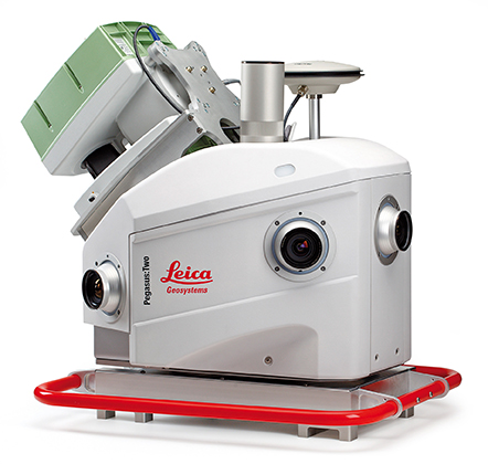
Leica Geosystems has introduced its next generation vehicle-independent mobile mapping platform, the Pegasus:Two. By calibrating imagery and LiDAR point cloud data, the Pegasus:Two delivers highly accurate and economical geospatial data in a 360° spherical view while providing two methods for extracting data — either through LiDAR or via photogrammetry.
With its enhanced sensor platform using six horizontal cameras, plus an optional rear camera and a skyward view camera, a single high-speed LiDAR sensor, and an external output for an additional sensor, the Pegasus:Two enables unlimited mobile mapping applications, from pavement analysis to geo-referencing railways systems, now possible within the same platform, the company said.
From hardware to post-processing, Pegasus:Two allows economic data collection by balancing the largest pixel to sensor ratio on the market (5.5 x 5.5 µm), delivering extremely high image resolution, in a 4-MB camera and using a single low-noise, high-speed profiler. Users can download data via Wi-Fi or wired Ethernet, or even faster by using the latest USB3 interface, by means of a multi-core, industrial PC with 1-TB storage and a solid state drive, enabling longer missions. An optional rotation mount, designed specifically for the Leica ScanStation P20, also makes mounting the terrestrial scanner upside down or right side up while also enabling left or right rotation.
The Pegasus:Two in its new streamlined housing with aerodynamic design.
Expanding on the success of Leica Geosystems’ mobile mapping software, the latest software now offers semi-automatic object extraction features, which enable easy-to-use two-click GIS metadata extraction or calculation of distances on-the-fly directly into ArcGIS for Desktop software.
Leica Geosystems also introduces an external timing output and trigger signal for use with a variety of additional sensors, from a thermal camera, to ground penetrating radar, sonar, or even a pollution monitor. The External Trigger feature synchronizes time stamping and coordinates user data with one simple click, making 3D mobile mapping very user-friendly.
Urban canyons. Equipped with the NovAtel’s ProPak6 high-precision receiver for the most demanding city or rugged environments, the Pegasus:Two offers users a truly global system. It is a future-proof investment that tracks signals of all available constellations, GPS, GLONASS, Galileo and BeiDou as well as L-band, SBAS, and QZSS band coverage to ensure the best signal even when moving through urban canyons. The system provides a low noise, 200hz Inertial Measurement Unit for tracking the vehicle path thereby ensuring data is positioned accurately.
Aerodynamic design. The Leica Pegasus:Two mobile mapping system now comes with a new streamlined and compact look and continues to fit in only two travel cases. A convenient handle surrounding the unit enables easy mounting on and off your vehicles. The Pegasus:Two is a vehicle-independent system with a rechargeable 11 hour battery, and can be used on any moving platform.
“The Leica Pegasus:Two platform is a unique complete solution,” said Stuart Woods, vice president for Leica Geosystems Geospatial Division. “By providing software and hardware designed to seamlessly work together, users not only receive the latest in mobile mapping technology but also optimal performance and faster workflows. By keeping the platform vehicle independent and adding new sensor options, we encourage our customers to find new ways, to try out different sensors, new revenue models, and new places to measure. ”
Along with the Pegasus:Two, the advanced prototype, Pegasus:T2, a trolley based mobile system weighing less than 20 kilograms will also be on display at the HxGN LIVE 2014 Conference in Las Vegas.
Hexagon AB, a global provider of design, measurement and visualization technologies, has acquired iLab Sistemas, a provider of planning and optimization solutions for the agro business sector, with special focus in the sugar and ethanol industries. iLab will, together with Arvus and Leica Agriculture, form the backbone of Hexagon’s Smart Agriculture Solution.
Headquartered in Ribeirão Preto, Brazil, iLab takes advantage of extensive know-how and various techniques to deploy highly parameterized solutions that address complex problems related to agricultural processes and production. They include linear programming, operations research, genetic algorithms, constraint-based programming, neural networks, statistics and advanced mathematics. ILab’s offerings include software optimization tools for every stage of crop growth — from planting, harvesting and logistics planning to area and asset management, scenario comparisons, and cost and budget forecasting — permitting value-added decision analysis and process automation.
“Together with its established software suite of end-to-end planning optimization solutions for sugarcane mills, iLab’s strong market footprint in the sugarcane industry will support the further development of the Smart Agriculture solution from Hexagon Solutions,” said Hexagon President and CEO Ola Rollén. “Additionally, iLab’s offerings complement the product portfolios of Hexagon brands Leica Geosystems, Sisgraph and Devex in areas such as fleet management, precision agriculture, automation platforms and control room technologies.”
ILab will be fully consolidated as of today. The acquisition has no significant impact on Hexagon’s earnings, Hexagon AB said.
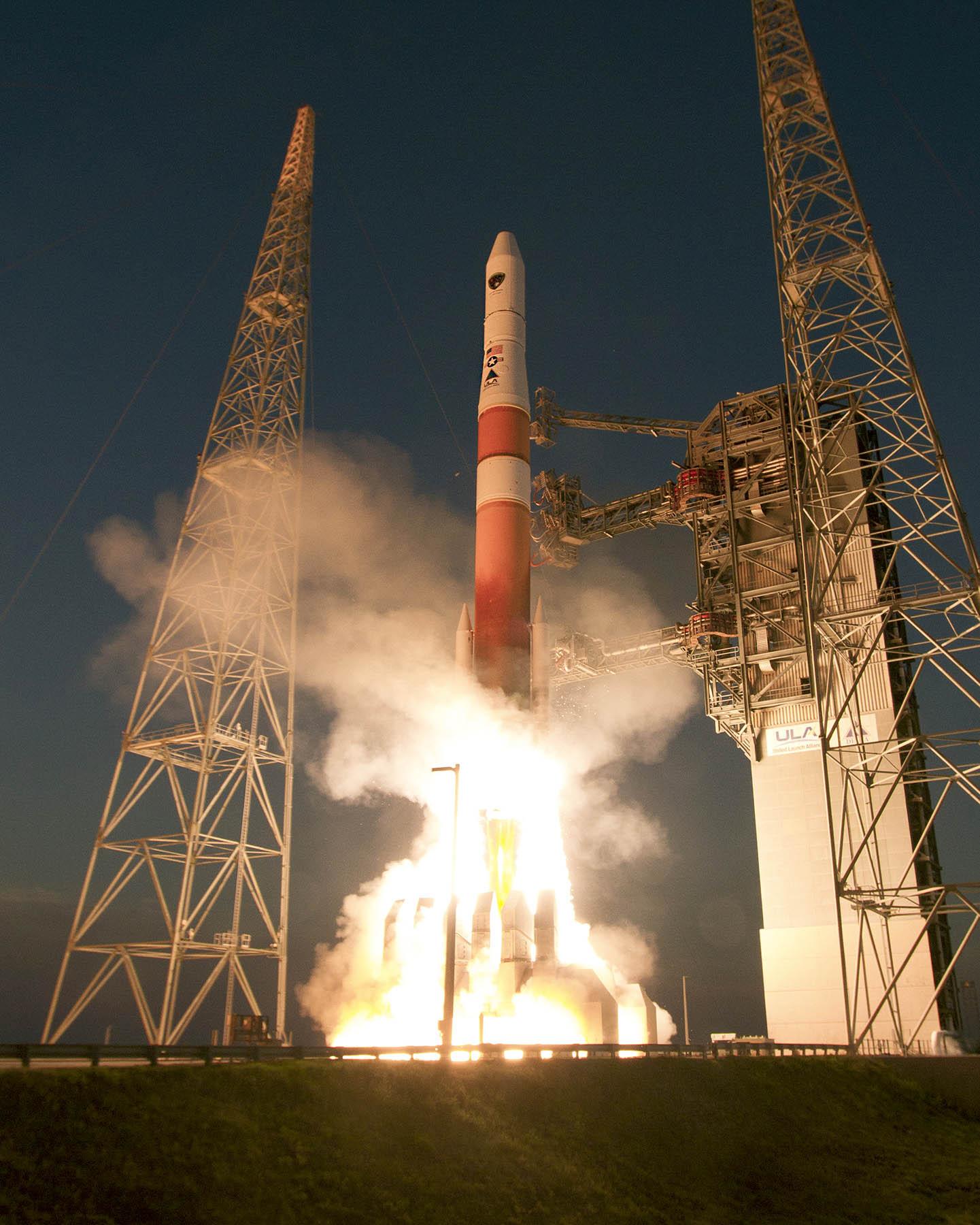
A sixth GPS IIF satellite was launched aboard a United Launch Alliance Delta 4 rocket from Cape Canaveral at 8:08 p.m. EDT May 16.
The satellite, designated GPS IIF-6 and built by Boeing, is one of the next-generation GPS satellites, incorporating improvements to provide greater accuracy, increased signals, and enhanced performance for users.
According to Boeing, each GPS IIF satellite has greater navigational accuracy through improvements in atomic clock technology and a new civilian L5 signal to aid commercial aviation and search and rescue operations.
Interestingly, the rocket is the first to be tracked via GPS instead of by radar.
United Launch Alliance’s Atlas and Delta rockets are transitioning to GPS metric tracking for range safety functions, which protect the public and property should a launch vehicle veer off course. The move is a money-saving upgrade to the military’s aging range infrastructure.
A special avionics system on the launcher transmitted the location. For decades, most rockets launching from Cape Canaveral, Florida, and Vandenberg Air Force Base, California, have been tracked by C-band radar.
Two more GPS IIF satellites are scheduled to launch before the end of the year.
Galileo FOC Satellites Reach Spaceport
Galileo’s first two full operational capability (FOC) satellites arrived in Kourou, French Guiana, on May 7, in preparation for launch this summer.
Manufactured by OHB in Bremen, Germany, with navigation payloads contributed by Surrey Satellite Technology Ltd. in Guildford, UK, these satellites — the first of 22 full-capability models — had spent several months at ESA’s Technical Centre, ESTEC, in Noordwijk, the Netherlands, where they underwent exhaustive testing in simulated space conditions.
The Galileo satellites are named for the children who won a painting competition organized by the European Commission in 2011. Doresa and Milena, the first two FOC satellites, will be launched together aboard a Soyuz rocket, joining the four Galileos already in orbit. Adam, the third Galileo FOC satellite, is now undergoing testing under space conditions at ESTEC. Anastacia, the fourth Galileo FOC satellite, will begin final testing at OHB in Bremen before being shipped to ESTEC.
“A steady stream of satellites is foreseen, coming from OHB to ESTEC for acceptance testing and then on to French Guiana,” said an ESA official.
Arianespace is already facing an exceptionally crowded launch manifest in 2014. A well-informed source opined, “If one were to hazard a guess, here is the most likely scenario: O3b arrives ready for launch several weeks ahead of Galileo and secures the June launch. Galileo moves to August and is promised a second launch in the autumn. O3b’s planned second launch in 2014 is moved to early 2015, as is the planned third launch of Galileo.
“The effect of these schedule slips on the cost of the Galileo program, which is about a year late — cost overruns that Tajani has vowed will not be paid by the commission — is a subject for another day.”
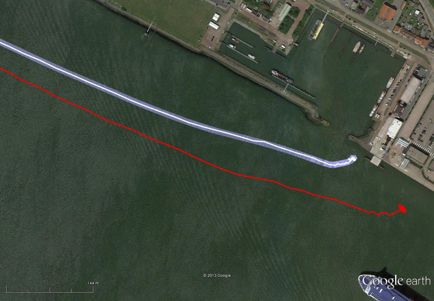
New Loran at 5 Meters
The red track is based on raw eLoran data without any corrections. The transparent blue line is made by GPS-RTK and is widened to 10 meters, giving the required ± 5-meter limits of eDLoran. The white line is output from the eDLoran receiver, which stays within the borders of the 10-meter-wide transparent blue line.
Dutch consultants Reelektronika showed results from a prototype enhanced differential Loran (eDLoran) system, extensively tested in the Europort (Rotterdam) area, at the European Navigation Conference held in April. The tests achieved accuracies of 5 meters. A full technical article describing the equipment, methodology, and test results will appear in the July issue of GPS World.
Harbor pilots require accuracies of 5 meters and some form of robustness or back-up for GNSS systems in case of jamming, unintentional interference, system failure, or other disruption.
The current eLoran system cannot get better than 10-meter accuracy. The new eDLoran opens up new possibilities for multiple applications:
Installing eDLoran reference stations is fast, simple, and cost effective.
As there is no data channel bandwidth limitation, multiple reference stations can be installed, which offers increased reliability and makes the system more robust against terrorism and lightning damage.
A single or multiple eDLoran servers can be installed in a protected area. There is hardly a practical limit in the number of differential reference stations to serve.
CNAV on L2C and L5 Initiated
On April 28, U.S. Air Force Space Command began broadcasting civil navigation (CNAV) messages on all operational GPS satellites capable of transmitting the L2C and L5 signals. L2C is designed for commercial needs and L5 meets safety-of-life transportation requirements.
“These new CNAV messages will enable manufacturers to develop and test advanced civil receivers and make for a more robust position, navigation, and timing (PNT) solution available to the civilian public,” said Maj. Gen. Robert E. Wheeler. “We do not anticipate any GPS satellite outages or legacy degradations as a result of the pre-operational deployment of these frequencies, and those currently using the GPS Standard Positioning Service should not be impacted.”
Initial CNAV broadcast occurs at a reduced data accuracy and update frequency compared to GPS signals in use today. In December 2014, CNAV data updates will increase to a daily rate, bringing L2C and L5 signal-in-space accuracy on par with legacy signals. However, derived position accuracy cannot be guaranteed during the pre-operational deployment. These signals are primarily used to test various equipment and should be employed at the users’ own risk; not used for safety-of-life or other critical purposes.
The Air Force will broadcast L2C messages with the health bit set “healthy,” as was the case during a June 2013 test. L5 messages will be set “unhealthy,” but as experience grows with L5 broadcast and implementation of signal monitoring is achieved, this status may change upon review.
Tony, I do take issue with the suggestion that the International GNSS Service (IGS) is somehow inferior and not reliable. I understand that Veripos is a commercial service designed for specific markets, but in central New South Wales (most populous state of Australia) it is 800 kilometers to the nearest base station.
You mention “So Veripos and other commercial providers overcome the weaknesses of IGS by providing a worldwide network that is well maintained — an infrastructure designed for high reliability and availability. Each base station has dual-redundant receiver and communications links.”
The IGS has 400+ base stations. How many does Veripos have? If a station goes down on the IGS there are still 399+ backups.
“There are three processing centers, two active and one on warm standby.”
The IGS has seven processing centers using different algorithms and combined solutions.
“There are seven geostationary satellites with a large degree of coverage overlap.”
OK, IGS is not a real-time service —yet… but some sites are.
How does Veripos handle coordinate dynamics (station velocities)?
Don’t get me wrong, Veripos looks like a very good service for its clients, but please don’t bag the IGS, which I liken to the United Nations of geodesy. Many good people and nations contribute (through their taxes which support infrastructure and personnel) to this service for the benefit of all.
Thanks for putting together this article. It’s good to know more about Veripos, and I hope to try it out soon.
Our survey editor Eric Gakstatter chimed in with this comment:
Good points. Have you used the IGS service yet? I’d like to give it a spin.
Craig Roberts replied:
Not me personally, but one of my students and some researchers have. You can download some open-source software (there are a few options) and try it out. Early days for the RT IGS but results seem encouraging. Still the standard issues with initialization times for RT PPP processing. We are also looking at the LEX message from QZSS which graces our shores thanks to the Japanese. Basically investigating near real-time positioning options for remote locations in the absence of CORS networks and/or mobile phone coverage.
Tony Murfin added:
No IGS bashing from me. IGS is a different tool of a different color. Point of the article is that if you want to run a business requiring PPP performance, you need to use a commercial service. If your application can stand some potential down-time and tolerate longer initiation times — for university and engineering R&D for instance — IGS is perfect. It’s free of charge and accurate and as reliable as you need. Good luck with IGS, it’s a great system!
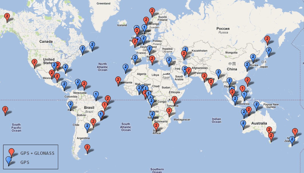
Tri-Band Multi-Constellation GNSS in Smartphones and Tablets
This article presents a single-chip BeiDou/Galileo/GLONASS/
GPS/QZSS/SBAS architecture for use in cell phones and tablets. The authors explain the advantages to end users of multiple constellations. They also examine the details of system interchangeability, multi-system issues, and how assisted-GNSS data operates with all constellations, including BeiDou.
By Frank van Diggelen and Kathy Tan
With GPS, GLONASS, SBAS, BeiDou, QZSS, and Galileo there are over eighty operational satellites. Why do we need all these satellites in the first place? The answer is simple: in urban environments we want a few (six to eight) good satellites with an unobstructed line-of-sight (LoS) to the receiver and good horizontal dilution of precision (HDOP). In order to achieve this, we need many more satellites in space than any single constellation. In this article, we address the following issues.
Receiver intersystem RF bias with a tri-band front-end. BeiDou uses a different RF section than GPS/Galileo/QZSS/SBAS and GLONASS. As a result, there is a receiver intersystem bias between BeiDou and each of these other systems—not just because BeiDou is on a different frequency, but because of the different RF path through the receiver. We explain how this bias is calibrated and removed.
In the space segment there are intersystem biases primarily caused by differences in time standards. We discuss time management and show how the different systems can be made interoperable.
BeiDou Assistance. In order to realize the benefits mentioned, we need infrastructure deployment for BeiDou assistance in accordance with 3GPP standards. We will discuss what is available, and what is left to do.
Coverage outside of China. Europeans can see more BeiDou satellites than Galileos. At the time of writing (March 2014) they could see approximately twice as many. Thus, when used in a multi-GNSS receiver, BeiDou is far from being just a regional system. We will provide coverage analysis, and live-test data, including a focus on Europe.
Finally, we will demonstrate all of the above in practice, explaining and showing how interchangeability is achieved, and where first fixes can be computed with no more than one of each satellite type.
Figure 1 illustrates the point referenced at the beginning, that we need many more satellites in space than any single constellation.
All of the lines in Figure 1 show signals that were actively tracked by the receiver at the position shown on the right. The orange lines are to satellites that are blocked, but the reflected signal is tracked. We do not want to use these measurements if we can help it, so we need many satellites to provide enough LoS signals.
Let’s look at the HDOP of the LoS signals. In this example, the HDOP for the three LoS GPS satellites was 50. For the three LoS GLONASS satellites, the HDOP was 45. However, with the combined GNSS constellation, the HDOP for the six LoS satellites was 2.2. In other words, we expect about a 20x accuracy improvement by using the combined constellation.
There are many places and times in cities where we see just one or two direct LoS signals from a particular constellation, and we need more than just GPS and GLONASS to get the desired number of good signals, thus explaining the desire and need for all available constellations.
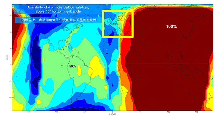
We’ll now look at the coverage provided by BeiDou2, which has five Geostationary satellites (GEOs), five inclined Geosynchronous satellites (GSOs), and four Medium Earth Orbit satellites (MEOs). With this 14-satellite constellation, the global coverage is as shown in Figure 2. This figure shows the percentage of time in a day that four or more BeiDou satellites are visible above a 10-degree mask angle. In the Asia-Pacific region, where the GEOs and GSOs are positioned, the coverage is predictably 100 percent. In fact, there are seven or eight BeiDou satellites visible in much of this region most of the time.
Figure 2. BeiDou2 global coverage.
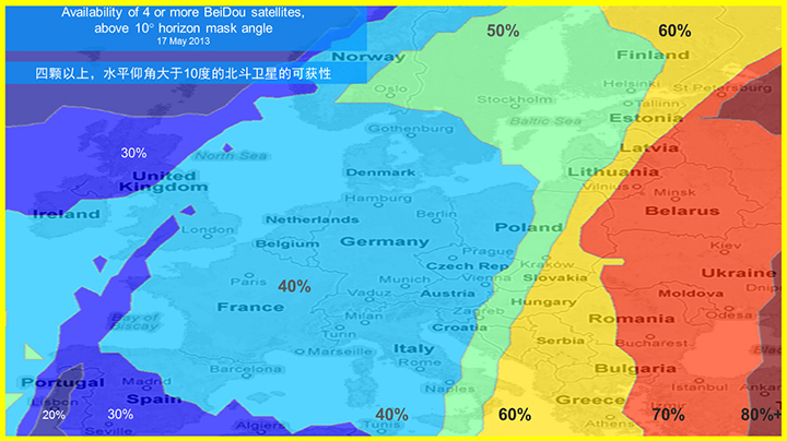
As shown in Figure 3, outside the Asia-Pacific region the coverage is also interesting. We see that at least four BeiDou satellites are available over Europe about half of the time. This is quite significant given the previous discussion; even one or two extra satellites can make all the difference in an urban environment. Another notable fact is that, for now at least, Europe can see more BeiDou than Galileo satellites.
Figure 3. BeiDou coverage over Europe. The different colors show the percent of time that four or more BeiDou satellites are visible above a 10° mask angle.
Technical Requirements
There are five significant technical requirements that we want to satisfy when creating a multi-GNSS receiver for consumer applications:
Three Separate RF Paths. To acquire and track all of the satellites already mentioned, we need three separate RF paths. Details follow in Section 3 (Front-End Architecture).
Search and Track capability for all visible GNSS satellites. The receiver must have the ability to search a very large number of code-frequency bins at once.
Host-Based. As much as possible, we want to make use of the host application processor (AP) and memory. This allows for tight integration with assistance data (which is coming from the host), other sensors, and other wireless data (such as Wi-Fi and Bluetooth for indoor locations). A host-based architecture also keeps size and cost as low as possible.
With Host-Offload. A significant trend in location applications is the need for “always-on low power” location. The host AP cannot be used for continuous position updates, since it draws too much power. So, while we want host-based location when the host AP is active (such as when navigating with turn-by-turn directions and a map), we also want a host-offload capability so that the GNSS chip can compute positions internally while the host is asleep.
Interchangeability. The ultimate requirement for multi-system GNSS is the ability to use any combinations of satellites as if they were all in the same constellation. This is summarized as “any four satellites will do.”
Front-End Architecture
From a cell phone/tablet perspective, the signals in space are all in the L1 band, with frequencies as shown in Figure 4. The key architecture feature of the GNSS front-end is that it should have three separate RF chains for the three separate frequencies-of-interest; see Figure 5.
Figure 4. Frequencies-of-interest for GNSS in cell phones.Figure 5. Front-end architecture showing three RF chains.
Baseband Architecture
The preferred architecture of a chip, as shown in Figure 6, is host-based to take advantage of the large host CPU when it is active. When the host CPU is asleep, a small, low-power, on-chip CPU is leveraged for background “always on” location. This enables applications such as geofencing to run without significantly reducing battery life.
Figure 6. Block diagram of the preferred architecture, showing a host-based configuration that includes a host-offload capability for geofencing and position caching on-chip when the host is asleep.
When the host is active, such as when you are actively using the phone for turn-by-turn navigation, the host AP is on and we want to make as much use as possible of the host AP and memory. This allows for tight integration with assistance data coming from the host, other sensors, and other wireless data (such as Wi-Fi and Bluetooth for indoor locations). A host-based architecture also keeps size and cost as low as possible, even with host-offload capability, which adds very little to the size of the chip.
Receiver Intersystem RF Biases
With the three different bands of frequencies, we will get RF group delays in the receiver front-end. These must be calibrated out by the receiver’s designer as part of the chip’s system design. If the group delay between BeiDou and GPS is not calibrated, it will lead to approximately three meters of bias between the two systems (Figure 7). Once it is calibrated, there is essentially no bias.
Figure 7. L1 frequency spectrum for BeiDou2, GPS, Galileo, QZSS, SBAS, and GLONASS.
Satellite Intersystem Biases
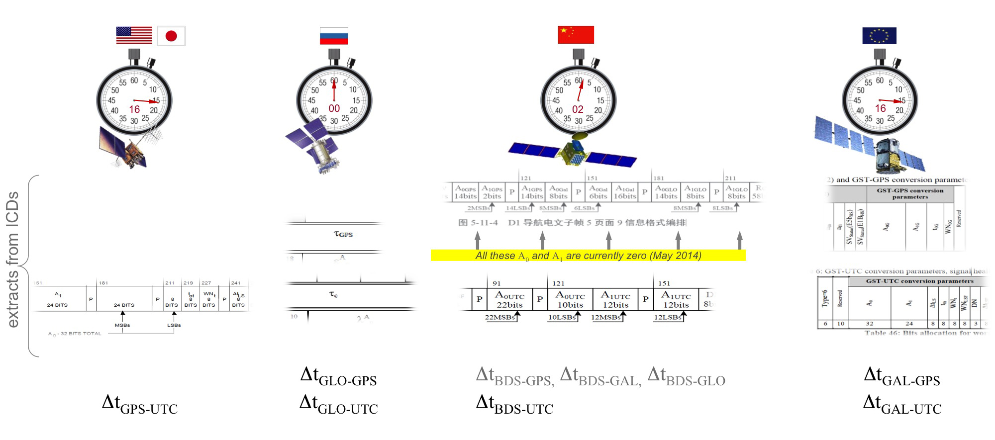
Different GNSS constellations run off their own master clocks; referenced to different realizations of UTC. GPS is referenced to UTC (USNO), QZSS is referenced to UTC (NICT), GLONASS to UTC (SU), BeiDou to UTC (NTSC), and Galileo to UTC (INRIM). GLONASS UTC (SU) differs from the others by 3 hours.
Furthermore, different systems treat leap seconds differently. This is indicated by the red arrows in the clocks in FIGURE 8. GPS, QZSS, BeiDou and Galileo system times are continuous and ignore leap seconds. Thus, each system time is ahead of UTC by a number of leap seconds. GPS time started in 1980 in synch with UTC; there have been 16 leap seconds since, so now GPS is 16 seconds ahead of UTC. QZSS and Galileo system times were started in synch with GPS. BeiDou system time was started in 2006 in synch with UTC; there have been 2 leap seconds since, so now BeiDou is 2 seconds ahead of UTC. GLONASS system time, on the other hand, includes leap seconds.
Apart from this, each of the different realizations of UTC is within several nanoseconds of the others.
To combine measurements from these different systems and avoid any time-induced intersystem biases, we need to resolve the time offsets. Each system transmits the delta-time between its system time and the systems that preceded it, as listed in Figure 8. To combine the systems, we either need to decode these data messages or obtain the delta-time values from Assisted GNSS.
Figure 8. Intersystem time differences and broadcast delta-time values from each system.
Note, however, that in the BeiDou broadcast Nav message the intersystem time-offset data values are all set to zero (even though the true offsets are not zero).
Assisted-GNSS Including BeiDou
Assisted GNSS, or A-GNSS, increases sensitivity and decreases the time-to-first-fix of a receiver by providing assistance data in the form of the receiver’s approximate position, time and frequency, as well as all data that the receiver might decode from the broadcast signals. The assistance data may also include data beyond what is broadcast, in particular, let’s focus on BeiDou time offsets. The BeiDou time offset to the other systems is included in the BeiDou broadcast Nav message as shown in Figure 8; however, at present these data values are all set to zero (even though the true offsets are not zero). Thus, in order to get these offsets and integrate BeiDou properly into a combined GNSS system, one must compute the offsets at a reference station and provide them as part of the assistance data, as shown in Figure 9.
Figure 9. A-GNSS provides broadcast satellite data over some other wireless network, as well as time-offsets between the different pairs of systems.
Commercial Implementation
The preferred architecture described in this article has been implemented in a commercial GNSS receiver that is now available for commercial host-based products, such as cell phones and tablets. The chip, Broadcom’s BCM47531, is the first consumer GNSS chip with a tri-band front-end capable of acquiring and tracking satellites from GPS, SBAS, QZSS, GLONASS, and BeiDou constellations, simultaneously; and operating in host-based mode for navigation and in host-offload mode for Always-On location.
Broadcom has collaborated with leading smartphone manufacturers to launch the first wave of BeiDou enhanced consumer smartphones. Figure 10 shows one of these smartphones being tested in Europe. Note the number of BeiDou satellites in view. As predicted by the availability plots shown earlier, there are many BeiDou satellites in view (in this case, six).
Figure 10. GPS/GLONASS phone and GPS/GLONASS/BeiDou phone being tested in Warsaw, Poland. Note the six BeiDou satellites (red) that are seen and tracked by the BeiDou phone.
Interchangeability: Any Four
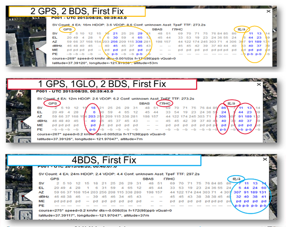
Now that we have addressed all of the major issues related to integrating different GNSS systems (in particular BeiDou), we can demonstrate the payoff.This is the achievement of interchangeability, where any GNSS satellites can be used together, as if they all belong to a single constellation. Figures 11 and 12 show assisted cold starts, where first fixes are obtained with no prior knowledge other than that provided by A-GNSS data. In each case, we show a different combination of satellites; including one satellite from each of four different constellations, and all four from BeiDou.
Figure 11. Interchangeability: Position fix with 1 GPS satellite, 1 GLONASS, 1 QZSS, and 1 BeiDou. The receiver is in Perth, Australia, where all of these constellations can be seen.Figure 12. Interchangeability: Assisted cold start, first fixes. Blue numbers show the satellites used in the position fix (top: two GPS and two BeiDou; middle: one GPS, one GLONASS, and two BeiDou; and bottom: four BeiDou only). The receiver is in San Jose, California, where four BeiDou satellites can be seen some of the time (some of the BeiDou GSOs can be seen and all the BeiDou MEOs can be seen for a few hours each day).
Multi-Constellation Robustness
While this article was being edited, the GLONASS system provided us with the most dramatic demonstration yet of the need for, and benefits of, multi-constellation receivers. On April 2, 2014, the GLONASS system failed spectacularly for a period of 11 hours. Receivers that used GPS and GLONASS had very large position errors, or no positions at all. While the receiver discussed in this article, the BCM47531, operated seamlessly. This receiver tracked GPS, GLONASS, QZSS and BeiDou satellites, correctly identified the faulty GLONASS satellites, and automatically stopped using them.
The details of the incident are as follows: The GLONASS control system uploaded incorrect orbit data to several satellites. When receivers used these satellites they had position errors of hundreds of meters, or no positions at all. At that time, the BCM47531 was being tested alongside a GPS/GLONASS receiver, and we have the data to show what happened. The receiver using only GPS/GLONASS suffered position errors of ten thousand meters, and long periods with no position at all; at the same time the multi-constellation receiver produced continual positions with normal accuracy. Figure 13 shows the test data — the left most image shows the route being driven, the middle image shows the data from the GPS/GLONASS receiver, and the right image shows the data from the BCM47531 multi-GNSS receiver. Figure 14 shows the details of the multi-GNSS receiver, you can see that no GLONASS satellites are being used.
FIGURE 13. Side-by-side tests of GPS/GLONASS receiver and multi-constellation receiver during the GLONASS incident of April 2, 2014. The GPS/GLONASS receiver produced errors of ten thousand meters and long periods with no position at all, while the multi-constellation BCM47531 operated seamlessly.FIGURE 14. Detail from the multi-constellation receiver when there is a problem with some satellites. The errors are recognized automatically by algorithms comparing the measurements to redundant measurements from the extra constellations, and the erroneous signals are not used.
This incident may raise the question: Why use GLONASS at all, why not just GPS? The answer is that in urban canyons, such as where this test was done, GPS alone does not have enough satellites to give the performance now expected in consumer products — for the reasons explained in the beginning of this article. Also, GPS, although it has been more reliable than GLONASS, is not immune to failures or jamming itself. The lesson of this incident is that reliability and accuracy comes from the combination of all the available constellations, with a receiver that can use the signals interchangeably.
Conclusion
We have shown the preferred architecture for a consumer GNSS receiver that includes all of the available constellations. We have addressed the major requirements of such a receiver for the consumer market, in particular, for cell phones and tablets. A receiver that meets these requirements is now available, the Broadcom BCM47531, has been designed into a new generation cell phones and tablets for 2014. Finally, we have shown how, with this receiver, the ultimate GNSS goal of interchangeability can be achieved.
Frank van Diggelen is vice president of technology at Broadcom Corporation, a consulting professor at Stanford University, and inventor of coarse-time GNSS navigation, co-inventor of Long Term Orbits for A-GNSS, and author of A-GPS: Assisted GPS, GNSS, and SBAS.
Kathy Tan is a senior principal engineer at Broadcom Corporation. She has worked on GNSS development and Assisted GNSS for Ashtech, Magellan, Global Locate and Broadcom. She received her MS and BS in electrical engineering from Fudan University, China.