Author: GPS World Staff

  • Averna DP-360 DOCSIS Protocol Analyzer Supports 16×4 Channel Bonding

    The Averna DP-360 protocol analyzer.
    The Averna DP-360 protocol analyzer.

    Averna has issued a new software release for the DP-360 DOCSIS Protocol Analyzer, featuring support for 16×4 channel bonding for broadband testing.

    Averna’s DP-360 provides functional DOCSIS and EuroDOCSIS network analysis, allowing for exceptional visibility into all layers of the network, the company said. Multiple system operators (MSOs), chipset manufacturers, product developers and certification bodies use the DP-360 to quickly find and correct trouble spots.

    New DP-360 release highlights:

    • Supports up to 16 single or bonded downstream channels for testing 16×4 configuration.
    • Upstream gain control, MER reading and power reading available in the remote API for automated power adjustment.
    • Automatic detection of modulation type (64-QAM or 256-QAM) and DOCSIS on downstream channels and lock on 4 upstream frequencies for faster setup and analysis.
    • Support for DOCSIS 3.0 Energy Management messages (EM-REQ & EM-RSP).

    DP-360 clients also have access to Averna’s new DOCSIS 3.1 Early Adopter Program, which offers MSOs and equipment vendors a smooth and cost-effective transition to Averna’s next-generation solution for testing their cable equipment based on the new DOCSIS 3.1 standard. Contact us for more details.

    “Our DOCSIS 3.1 Early Adopter Program covers current D3.0 as well as upcoming D3.1 testing needs and is specifically designed to make the technology switch as easy and cost effective as possible for our clients and partners,” commented Alex Pelland, Director of Broadband Test Strategy for Averna. “The DP-360 is the most advanced DOCSIS protocol analyzer available today and, with our forward-looking transition program, it will provide a substantial return on investment for years to come.”

    The new DP-360 software release is available at no cost to customers with a valid DP-360 maintenance and support agreement.

  • skobbler Updates GPS Navigation App for iOS 7

    skobbler has launched a new version of GPS Navigation optimized for iOS 7. The app now includes a travel guide, hyperlocal search, and mapping technology provided by skobbler’s NGx map engine.

    Powered by data from the OpenStreetMap — a free and editable map of the world built by over 1 million voluntary contributors and map enthusiasts — GPS Navigation delivers true “hybrid” functionality, allowing users to switch between online or optional offline access through in-app purchases of downloadable maps, regardless of location or cellular connection, skobbler said.

    Offline functionality allows for fast and reliable results using only a device’s GPS receiver rather than a network connection, meaning turn-by-turn navigation, alternate routing and various search capabilities are provided in full without a data connection.

    GPS Navigation now features a comprehensive in-app travel guide and hyperlocal search via Wikitravel — which provides users with more than 90,000 pages of worldwide travel information in the English language alone — and TripAdvisor integrations.

    Much like GPS Navigation’s online-offline mapping functionality, users can also access travel guide information with or without Internet connectivity, allowing access to the app’s travel features without roaming charges by opting for offline usage.

    GPS Navigation is available for a one-time purchase of $0.99 via the iTunes App Store.

  • Meitrack Offers MT90 Personal Tracker

    Meitrack Offers MT90 Personal Tracker

    The Meitrack MT90.
    The Meitrack MT90.

    GPS tracking company Meitrack is offering the MT90, a GPS personal tracker for elderly, children, patients and lone workers. It can be hung around the neck or carried in a pocket or bag. The MT90 weights 65 grams and is 77 x 47 x 20 millimeters in size.

    The MT90 can last 16 hours in normal mode and up to 60 hours in power-saving mode. It is waterproof to IP66 standards, and can handle 5% to 95% air humidity, which ensures it is reliable in the case of unexpected rain or accidents with small children.

    MT90 is Meitrack’s first GPS tracker that works with SiRFStar IV GPS and quad band GSM 850/900/1800/1900 Mhz base station, facilitating bi-module positioning technology. Using this advanced technology, the MT90 can more accurately and precisely track its location.

    Equipped with an SOS button, people using the MT90 tracking device are only one click away from calling the Rescue Service Center for help. In addition, the SOS button can be programmed to call multiple emergency numbers until one picks up. This device can facilitate two-way communication along with the option to listen-in, which can be helpful when discretely trying to locate a missing person.

    The MT90 GPS tracker uses Meitrack’s protocol to track by SMS and GPRS. The MT90 has an built-in motion sensor, built-in battery, GPS blind area alarm, low-battery alarm and speeding alarm.

  • Galileo Achieves First Airborne Tracking

    Galileo Achieves First Airborne Tracking

    Aircraft position as obtained by Galileo-only receiver during Netherlands flight.
    Aircraft position as obtained by Galileo-only receiver during Netherlands flight.

    The European Space Agency’s Galileo satellites have achieved their first aerial fix of longitude, latitude and altitude, enabling the inflight tracking of a test aircraft. ESA’s four Galileo satellites in orbit have supported months of positioning tests on the ground across Europe since the first fix in March.

    Now the first aerial tracking using Galileo has taken place, marking the first time that Europe has been able to determine the position of an aircraft using only its own independent navigation system. The milestone took place on a Fairchild Metro-II above Gilze-Rijen Air Force Base in the Netherlands at 12:38 GMT on November 12. It was part of an aerial campaign overseen jointly by ESA and the National Aerospace Laboratory of the Netherlands, NLR, with the support of Eurocontrol, the European Organisation for the Safety of Air Navigation, and LVNL, the Dutch Air Navigation Service Provider.

    A pair of Galileo test receivers was used aboard the aircraft, the same kind employed for Galileo testing in the field and in labs across Europe. They were connected to an aeronautical-certified triple-frequency Galileo-ready antenna mounted on top of the aircraft.

    Fairchild Metro-II aircraft used for Galileo airborne testing.
    Fairchild Metro-II aircraft used for Galileo airborne testing.

    Tests were scheduled during periods when all four Galileo satellites were visible in the sky – four being the minimum needed for positioning fixes. The receivers fixed the plane’s position and, as well as determining key variables such as the position, velocity and timing accuracy; time to first fix; signal-to-noise ratio; range error; and range–rate error.

    Testing covered both Galileo’s publicly available Open Service and the more precise, encrypted Public Regulated Service, whose availability is limited to governmental entities.

    Flights covered all major phases: take off, straight and level flight with constant speed, orbit, straight and level flight with alternating speeds, turns with a maximum bank angle of 60º, pull-ups and push-overs, approaches and landings.

    They also allowed positioning to be carried out during a wide variety of conditions, such as vibrations, speeds up to 456 km/h, accelerations up to 2 ghorizontal and 0.5–1.5 gvertical, and rapid jerks. The maximum altitude reached during the flights were 3000 m.

    NLR’s Fairchild Metro-II has previously performed initial European GPS testing in the 1980s, and the first tests of the European Geostationary Navigation Overlay Service, EGNOS, which sharpens GPS accuracy and monitors its reliability over Europe for high-accuracy or even safety-of-life uses.

    The definition and development of Galileo’s in-orbit validation phase were carried out by ESA and co-funded by ESA and the EU.

    The Full Operational Capability phase is managed and fully funded by the European Commission. The Commission and ESA have signed a delegation agreement by which ESA acts as design and procurement agent on behalf of the Commission.

  • Loctronix Ships ASR-2300 Software-Defined Radio Module for Indoor/Outdoor Positioning

    Loctronix Ships ASR-2300 Software-Defined Radio Module for Indoor/Outdoor Positioning

    Loctronix ASR2300 module.
    Loctronix ASR-2300 module.

    Loctronix Corporation, a provider of unified positioning solutions for GNSS-challenged environments, announced that it has begun shipments of its new software-defined radio (SDR) module, the ASR-2300, for developing high-performance positioning, navigation and timing (PNT), and communication applications.

    “The ASR-2300 delivers advanced SDR capabilities in a small, mobile form-factor enabling developers to readily create and field complex SDR-based solutions. Featuring a 2×2 multiple-input, multiple-output (MIMO) RF transceiver and an array of inertial sensors, the open-source ASR-2300 is an ideal platform for tapping advanced, multi-sensor/signals of opportunity for high-performance PNT,” said Michael Mathews, Loctronix’ CEO and founder.

    Loctronix ASR-2300 kit.
    Loctronix ASR-2300 kit.

    “Unique amongst the growing number of SDRs, Loctronix’ ASR-2300 provides multiple, fully-integrated RF paths supporting reception of GNSS, cellular, ISM band, and UHF signals of opportunity, making it well-suited for demanding scientific, military, aerospace and commercial/industrial applications, such as UAV/UAS navigation, GPS-challenged or -denied tracking and navigation, combined communications and navigation radios, and GPS integrity monitoring and validation,” Mathews noted.

    The MIMO transceiver module incorporates two wideband Field Programmable RF (FPRF) transceivers (300 MHz to 3.8 GHz), 10-axis accelerometer/gyro/compass/barometer sensors, and a large programmable FPGA capable of over 300 MiB/sec sustained communications with a host processor via USB 3.0 interface.  The module’s nine integrated RF path options and low size, weight, and power characteristics contribute to ease of integration and portability, Loctronix said.  Accommodating both internal 1 PPM TCXO or external frequency reference, multiple ASR-2300s can be inter-connected via an expansion port and/or UART interface, supporting real-time reception / transmission of 4, 6, 8 or more signals without the need for significant additional hardware.

    Developers looking to create solutions for demanding military, scientific and industrial applications will realize greater functionality with the ASR-2300, thanks to its multiple sensor and multiple frequency capabilities, Loctronix said. Additionally, access to a variety of user-friendly development tools facilitates waveform experimentation and helps speed the creation of these new solutions, resulting in shorter development times and lower development costs for high-performance PNT applications.

    Bundled kits, which include the module, housing, and power/data communications/RF interfaces, are priced at $1,600 with a special educational discount available for qualified institutions.  The ASR-2300 SDR is available directly from Loctronix.

  • New Report on Global Military GPS/GNSS Market Looks at Next Decade

    Reportstack has announced a new report on The Global Military GPS/GNSS Market 2013-2023.  This report offers the reader detailed analysis of the global military GPS/GNSS  market over the next 10 years, alongside potential market opportunities to enter the industry, using detailed market size forecasts, Reportstack said.

    A satellite navigation system provides GPS positioning from a global perspective, and is therefore of utmost importance for modern-day military operations, which rely on accurate real-time data on hostile forces in order to carry out precision attacks, Reportstack said. It is here that GPS/GNSS devices assume an important role, as they are imperative to transfer signals from these satellites back to earth.

    The U.S. is the highest spender on military GPS/GNSS navigation, and is responsible for 42.9% of the global military GNSS devices market. Others major spenders in this sector include Russia, the UK, China and India. In July 2013, India launched the IRNSS-1A, the first of seven satellite constellation to be deployed under the Indian Regional Navigation Satellite System (IRNSS) program to be completed between 2015-2016. And China’s BeiDou is scheduled to be operational by 2020.

    Another factor driving the market is the integration of satellite navigation technology with other navigation systems, such as the inertial navigation system (INS) and gyro, as GPS devices are to be used in order to decipher data correctly, Reportstack said.

    The increasing demand for satellite navigation and communications is driven primarily by the desire of militaries to monitor more areas and derive accurate information by a range of GNSS receivers/sensors in the shortest time possible. Major military aircraft and helicopters are dependent on GPS embedded INS systems for effective navigation. Similarly, naval vessels and guided munitions are increasingly relying on the collaboration of laser, gyro, INS, and satellite navigation technologies to derive accurate real time data.

    Furthermore, it has been observed that the usage of standard positioning services/open service receivers, which use unencrypted signal for non-combat purposes has increased, and is expected to drive demand and encourage expenditure, Reportstack said. The military GPS/GNSS technology is expanding its horizon beyond the basic characteristics of navigation and tracking. The use of GPS, in conjunction with a number of software applications, has expanded its use in military operations. A number of new technologies are now embedded with GPS receivers to produce a more sophisticated military tool.

    Recently, a Swiss-based company developed a device called GPS Log Book based on u-blox technology. The new device has extended the scope of GPS technology to the administrative side of military operations. It provides an easy way for military drivers to automatically keep an accurate travel log book which can be securely accessed later from anywhere via a web interface. Information logged includes route, speed, and distance traveled. It also keeps a close record of fuel used by the vehicle, based on the distance traveled at various speed levels.

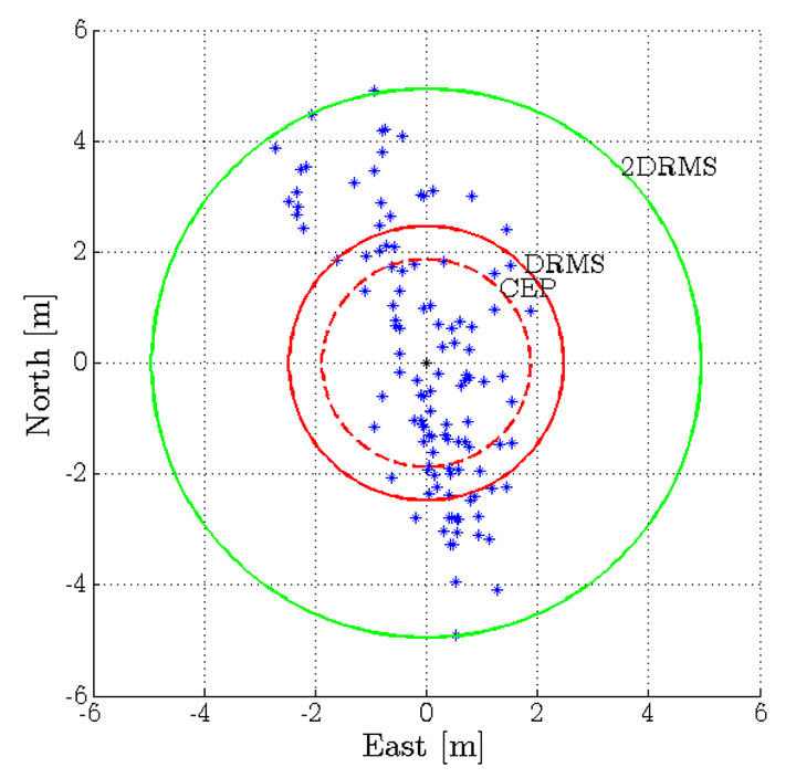
    The advent of Differential GPS (DGPS), an enhancement to GPS, which provides improved location accuracy, from the 15-meter nominal GPS accuracy to approximately 10 cm, has further expanded the scope of GPS in missile technology. The intercontinental ballistic missiles, which are capable of hitting targets across thousands of miles navigation, use inertial navigation with DGPS receivers. The advent of DGPS is expected to be one of the most significant steps in accurate missile targeting for militaries across regions.

    The companies mentioned in this report are Northrop Grumman, Raytheon, Rockwell Collins , Lockheed Martin, ITT Exelis, Thales, and BAE Systems. More details and table of contents about this report can be found by visiting The Global Military GPS/GNSS Market 2013-2023 report.

  • CHC Delivers 520 GNSS Receivers in Big Myanmar Contract

    CHC Delivers 520 GNSS Receivers in Big Myanmar Contract

    The X91+ GNSS receiver by CHC Navigation.
    The X91+ GNSS receiver by CHC Navigation.

    CHC Navigation announced today the successful delivery of 520 units of X91+ GNSS receivers to the Settlement and Land Records Department (SLRD), a part of the Myanmar Ministry of Agriculture and Irrigation.

    Awarded as one of the world’s largest GNSS tenders, CHC Navigation successfully delivered 520 units of X91+ receivers within the tight 60-day time frame allowed by the tender.

    “This might be the largest single contract award for RTK receivers I’ve ever heard of,” commented Eric Gakstatter, GPS World’s survey editor.

    The Settlement and Land Records Department activities encompass the collection of agricultural statistics, annual assessment of land revenue, land lease and tenure, and many other agricultural land administration tasks.

    CHC Navigation, in cooperation with its distributor, IGS Company Limited, demonstrated the performance of the X91+ during stringent field technical assessments versus other major GNSS industry players.

    CHC Navigation demonstrates the X91+ during field technical assessments.
    CHC Navigation demonstrates the X91+ during field technical assessments.

    “We are excited about the international recognition of CHC’s GNSS solution by leading governmental organizations. I believe the win highlights our firm commitment to provide high precision, outstanding quality products and more over dedicated support and services,” said George Zhao, CEO of CHC. “The award of this significant tender is a real achievement in CHC international development.”

    The X91+ GNSS receiver is a compact 220-channel GNSS receiver designed for high accuracy and productivity in harsh environments. According to CHC, the receiver has an easy-to-use, efficient and intuitive work flow, and is optimized for efficient RTK positioning.

  • Qualcomm Introduces Chipset with Integrated 4G LTE World Mode for High-Volume Smartphones

    Qualcomm Technologies, Inc., has introduced the Qualcomm Snapdragon 410 chipset with integrated 4G LTE World Mode. According to Qualcomm, the delivery of faster connections is important to the growth and adoption of smartphones in emerging regions, and Qualcomm Snapdragon chipsets are poised to address the needs of consumers as 4G LTE begins to ramp in China.

    Snapdragon 410 chipsets support all major navigation constellations: GPS, GLONASS, and China’s new BeiDou, which helps deliver enhanced accuracy and speed of location data to Snapdragon-enabled handsets.

    The new Snapdragon 410 chipsets are manufactured using 28-nm process technology. They feature processors that are 64-bit capable along with superior graphics performance with the Adreno 306 GPU, 1080p video playback and up to a 13 megapixel camera. Snapdragon 410 chipsets integrate 4G LTE and 3G cellular connectivity for all major modes and frequency bands across the globe and include support for dual and triple SIM. Together with Qualcomm RF360 front-end solution, Snapdragon 410 chipsets will have multiband and multimode support. Snapdragon 410 chipsets also feature Qualcomm’s Wi-Fi, Bluetooth, FM and NFC functionality.

    The chipset supports all major operating systems, including the Android, Windows Phone and Firefox operating systems. Qualcomm Reference Design versions of the processor will be available to enable rapid development time and reduce OEM R&D, designed to provide a comprehensive mobile device platform. The Snapdragon 410 processor is anticipated to begin sampling in the first half of 2014 and expected to be in commercial devices in the second half of 2014.

    Qualcomm Technologies also announced for the first time the intention to make 4G LTE available across all of the Snapdragon product tiers. The Snapdragon 410 processor gives the 400 product tier several 4G LTE options for high-volume mobile devices, as the third LTE-enabled solution in the product tier. By offering 4G LTE variants to its entry level smartphone lineup, Qualcomm Technologies ensures that emerging regions are equipped for this transition while also having every major 2G and 3G technology available to them. Qualcomm Technologies offers OEMs and operators differentiation through a rich feature set upon which to build innovative high-volume smartphones for budget-conscious consumers.

    “We are excited to bring 4G LTE to highly affordable smartphones at a sub $150 ( ~1,000 RMB) price point with the introduction of the Qualcomm Snapdragon 410 processor,” said Jeff Lorbeck, senior vice president and chief operating officer, Qualcomm Technologies, China. “The Snapdragon 410 chipset will also be the first of many 64-bit capable processors as Qualcomm Technologies helps lead the transition of the mobile ecosystem to 64-bit processing.”

    Qualcomm Technologies will release the Qualcomm Reference Design (QRD) version of the Snapdragon 410 processor with support for Qualcomm RF360 Front End Solution. The QRD program offers Qualcomm Technologies’  technical innovation; customization options; the QRD Global Enablement Solution, which features regional software packages, modem configurations, testing and acceptance readiness for regional operator requirements; and access to a broad ecosystem of hardware component vendors and software application developers. Under the QRD program, customers can rapidly deliver differentiated smartphones to value-conscious consumers. There have been more than 350 public QRD-based product launches to date in collaboration with more than 40 OEMs in 18 countries.

  • Broadcom Offers GNSS Location Chip with BeiDou Support

    Broadcom Offers GNSS Location Chip with BeiDou Support

    The Broadcom BCM47531 GNSS chip generates positioning data from five satellite constellations simultaneously, including BeiDou.
    The Broadcom BCM47531 GNSS chip generates positioning data from five satellite constellations simultaneously, including BeiDou.

    Broadcom Corporation has introduced the BCM47531, a GNSS chip that generates positioning data from five satellite constellations simultaneously — GPS, GLONASS, QZSS, SBAS and BeiDou. The newly added BeiDou constellation increases the number of satellites available to a smartphone, enhancing navigation accuracy, particularly in urban settings where buildings and obstructions can affect performance.

    More than 226 million mobile phones were sold to end users in Asia in the first quarter of 2013, increasing the region’s share of global mobile phones to 53.1 percent, according to Gartner (“Market Share Analysis: Mobile Phones, Worldwide,” 1Q13). As smartphone adoption continues to accelerate, users continue to identify location and mapping as a top requirement. Broadcom’s new GNSS system-on-chip (SoC) is based on its widely deployed architecture that reduces the time to first fix and allows smartphones to quickly establish location and rapidly deliver mapping data. The SoC also features a tri-band tuner that enables smartphones to receive signals from all major navigation bands (GPS, GLONASS, QZSS, SBAS, and BeiDou) simultaneously. By allowing use of any combination of satellites, users experience more accurate and consistent location performance in Asia and throughout the world.

    “Broadcom’s new GNSS chip with BeiDou support provides OEMs with a cost-effective, low-power solution to deliver enhanced positioning capabilities for challenging city environments,” said Charles Abraham, Broadcom vice president & general manager, GPS. “Drawing on Broadcom’s long history of GNSS innovation, our new platform improves the navigation experience of smartphone users in most regions of the world and unlocks new location-aware applications.”

    The BCM47531 platform is available with Broadcom’s location-based services (LBS) technology that delivers satellite assistance data to the device and provides an initial fix time within seconds, instead of the minutes that may be required to receive orbit data from the satellites themselves.

    Key Features and Benefits:

    • Simultaneous support of five constellations (GPS, GLONASS, QZSS,SBAS and BeiDou) allows for position calculations based on measurements from any of 88 satellites.
    • Broadcom’s tri-band tuner brings the ability to receive all navigation bands, GPS (which includes QZSS and SBAS), GLONASS and BeiDou simultaneously to the commercial GNSS market without having to reconfigure and hop between bands.
    • Utilizes BeiDou signals for up to 2x improved positioning accuracy.
    • Best-in-class Assisted GNSS (AGNSS) data available worldwide from Broadcom’s hosted reference network.
    • Allows a device to interchangeably use the best signal from any satellite regardless of the constellation, ensuring better accuracy in urban and mountainous environments.
    • Features advanced digital signal processing for interference rejection that enables satellite signal search and tracking during LTE transmission.
    • Leverages Broadcom’s connectivity solutions including Wi-Fi, Bluetooth
    • Smart, Near Field Communications (NFC), Instant Messaging System (IMES) and handset inertial sensor data for best indoor/outdoor location.

    The BCM47531 is now sampling.

  • Non-Profit Seeks Help with GIS Project for Costa Rica through Crowdsourcing

    20131013143401-Fullscreen_capture_10132013_33021_PM

    Geoporter, a non-profit focused on leveraging advanced mapping technology to empower communities to address burgeoning problems from within, has launched an Indiegogo crowdsourcing campaign to help support continued work and expansion. Funds will be used to provide resources to current projects in Costa Rica, while allowing the team to establish new operations in other areas globally.

    Besides financial donations, the group is seeking serviceable digital cameras, GPS units, and laptop computers — worn but working well.

    The organization uses GPS-driven technology to map behaviors in a community, allowing them to better define problems, develop and implement solutions, and evaluate the effectiveness of their efforts for continual improvement. The technology can be used to address a wide variety of problems, from tackling trash build up in the area to monitoring whale patterns in order to facilitate more sustainable tourism practices. In Costa Rica, the Geoporter team worked to map mosquito larva and water treatment to help reduce the risk of exposure to dengue fever.

    “It’s exciting and rewarding work,” said co-founder Anita Palmer. “We’re going into areas where we can make a real difference in the everyday lives of people through the power of data analysis. What’s more, we’re helping to reverse trends that would otherwise have regional and, in some cases, global implications.”

    gI_65702_Kids-trash-gpsGeospatial mapping is not new, but it has traditionally been executed by teams of experts in the aftermath of a crisis. Geoporter’s approach is a proactive one, where experts move into communities as challenges are developing so they can effect change before there’s a real problem. Still, building and sustaining a team of experts would have been cost-prohibitive, so Geoporter decided it would try something radical: teaching people within these communities to use the technology themselves.

    “We started by training adults and youth,” explains Geoporter Director Amy Work. “Now, children in the area are taught how to use the technology in and outside of school. We have eight-year-olds navigating commercial-grade geospatial mapping technology like Esri ArcGIS Online better than some of the professionals I’ve known. The lessons they’re learning today will not only enable them to take ownership of their communities, but provide them with skills they can leverage through adulthood.”

    Geoporter is hoping to use the IndieGoGo campaign to raise the funds necessary to continue their work in Costa Rica, and are looking to expand into other areas over the course of the next year. Donations will go towards funding technology, educator travel and living expenses, and community staffing.

    To support the Geoporter mission or learn more about their work, visit the Indiegogo campaign by clicking here.

  • Galileo Position Fix with Open Source Software Receiver Achieved

    Galileo Position Fix with Open Source Software Receiver Achieved

    First GNSS-SDR Galileo standalone position fix using the four available satellites (Position obtained at the CTTC headquarters on 2013-Nov-10 15:52:14 UTC) GNSS-SDR.
    First GNSS-SDR Galileo standalone position fix using the four available satellites (Position obtained at the CTTC headquarters on 2013-Nov-10 15:52:14 UTC).

    For the first time, position fixes in real time using signals from Galileo have been achieved with an open source software receiver. The milestone was achieved by a research team from the Statistical Inference Department at the Centre Tecnològic de Telecomunicacions de Catalunya (CTTC), which manages the development of the open source project GNSS-SDR.

    Professional, full-featured receivers are expensive, and even in those cases the users have limited access (if any) to know exactly how position and time information were computed, CTTC said. In addition, these receivers exhibit very few upgrading capabilities. A software receiver allows all kind of modifications and inspections. “GNSS-SDR unleashes the full potential of the signals and, best of all, it is open and for free,” said Carles Fernández-Prades, GNSS-SDR project manager and Head of the Communications Systems Division at CTTC.

    GNSS-SDR 2D ENU coordinates precision for the Galileo position fix.
    GNSS-SDR 2D ENU coordinates precision for the Galileo position fix.

    A GNSS software receiver is a computer program that performs all the signal processing from raw satellite signals to the computation of position, velocity and time, just as is done by the GPS chips that are embedded in smartphones and other devices with satellite-based positioning capabilities. The key difference relies on the great flexibility in the design, upgradability and the experimentation possibilities that the software version allows, in opposition to integrated circuits, true black boxes with inputs and outputs but with no accessible information about what is going on inside of them.

    “With GNSS-SDR, researchers and technology enthusiasts can easily change the implementation of a certain functional block and assess the impact of that change on the whole receiver performance,” said Pau Closas, GNSS-SDR scientific advisor and Head of the Statistical Inference Department at CTTC. “This paves the way to innovative mass-market, industrial and scientific applications that could make use of Galileo signals but require non-standard features which are not present in mass-market receivers nor in costly professional equipment.”

    The first Galileo-based positioning fix, obtained by Javier Arribas using a general purpose GNSS antenna and a RF front-end connected to a commodity PC running GNSS-SDR represents an important milestone in the research on GNSS receiver design. “Next steps will be devoted to provide outputs in standard formats that will allow the application of geodesic-grade tools for extremely precise positioning (on the order of centimeters) and higher degrees of reliability,” Arribas said.

    GNSS-SDR is the first open source solution that offers this possibility, CTTC said. The source code released under the GNU General Public License (GPL) secures practical usability, inspection, and continuous improvement by the research community, allowing the discussion based on tangible code and the analysis of results obtained with real signals. The source code is complemented by a development ecosystem, consisting of a website, as well as a revision control system, instructions for users and developers, and communication tools.

    With GNSS-SDR, researchers from CTTC (with the aid of an open community created around the project, such as the students participating in the Google Summer of Code program in 2012 and 2013 Luis Esteve, Mara Branzanti, Daniel Fehr and Marc Molina) are offering a tool that fosters the use of GPS and Galileo signals in unexpected new ways, making possible applications with unforeseen benefits in a wide range of fields, such as geodesy, robotics, unmanned vehicles and safety-related systems.

  • Navtech Partners with DW International on GNSS Coverage for Flight Planning

    Navtech, Inc., a Toronto-based provider of flight operations services, has entered a partnership with DW International (DWI). The UK-based aviation consultancy will provide Navtech Flight Plan (NFP) customers with GNSS RAIM/RNP Prediction Services. This service, required to meet FAA Performance Based Navigation (PBN) guidelines and state requirements, fits into Navtech’s current suite and provides GPS coverage information for routes and airports as part of the flight planning process.

    Navtech serves more than 350 airlines and aviation services customers. Its product suite includes aeronautical charts, navigation data solutions, flight planning, aircraft performance software (take-off/landing, weight and balance), and crew planning solutions.  Many of Navtech’s products can be configured as part of an EFB solution, including take-off data calculation, weight and balance, and aeronautical charts.

    DWI is an independent consultancy which provides technical support in the fields of air navigation, civil air communications and air traffic management. The company also develops and maintains bespoke (custom) software and manages websites that support air operations. The company has access to a wide range of experienced technical experts including airworthiness and operational approvals inspectors, aviation safety engineers and air traffic management consultants.

    “The relationship with DWI will strengthen the Navtech Flight Plan product,” said Bill Macey, Product Director, Flight Planning at Navtech. “We are continuously motivated to provide our customers with superior quality offerings, especially when they are supported by a partnership with a reputable aviation firm like DWI. Their reliable 24/7 service along with their initial help desk support will afford our users peace of mind.”

    The GRPS service allows operators to comply with all FAA, European, ICAO and other worldwide RAIM requirements and guidelines. Specifically, real-time tailored RAIM predictions for RNAV and RNP operations are delivered through NFP via the internet to NFP users.

    The service is fully automated for dispatchers/flight planners to obtain their predictions as they plan their route and the service allows dispatchers/flight planners and crew to plan around periods of reduced GNSS availability by taking all route details from the flight plan and calculating RAIM availability for all route types (such as enroute, terminal, approach) on a leg-by-leg basis. Destination and alternate airports for RNAV and RNP around the world are included. GRPS also processes GPS NANUs, evaluating and interpreting them in view of establishing their relevance to the RAIM availability.

    “DWI is pleased to be working with Navtech to provide their customers with the RAIM predictions they need for GNSS-based operations,” said John Wilde, CEO of DWI. “The consistency and availability of our service provides the reliability NFP users require.”