Author: GPS World Staff

  • GPSWorld.com More User-Friendly Than Ever

    gpsworld.com
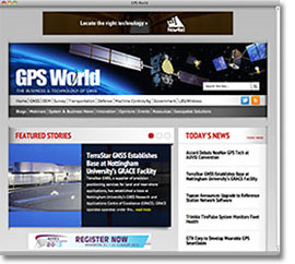
Cleveland — August 19, 2013 — GPS World, the industry-leading publication and website focused on GNSS, has launched a new, improved website redesign at env-gpsworld-integration.kinsta.cloud. The site offers a clean, fresh look with an easy-to-navigate layout and the introduction of useful features.

    The redesign includes technological and aesthetic enhancements that provide improved navigation, better organization of content, and make use of current web technologies. GPS World intends for the new design to better meet the needs of its readers and visitors by making the site more functional, intuitive, and appealing.

    Enhancements to the website include:

    • A rotating “Featured Stories” slider so visitors can quickly see important content
    • “Today’s News” with at-a-glance headlines
    • A Video Spotlight featuring news and advertiser-sponsored videos, connected to GPSWorldTV, the magazine’s YouTube channel
    • A Product Showcase
    • An up-to-the-minute Twitter Feed

    “I’m excited to unveil GPS World’s new website design,” said Alan Cameron, GPS World editor and publisher. “We wanted to create a site that provides a positive experience for our visitors, providing them with the news they need when they need it, as well as thoughtful commentary on the industry.”

    Hand-in-hand with the site redesign, the GPS World newsletters have been given a facelift. The weekly Navigate! newsletter was the first to show off a new attractive, crisp design. The monthly, market-specific newsletters will follow in the coming month, including Survey Scene, Professional OEM, Defense PNT, GSS Monthly, GeoIntelligence Insider, and the newly combined Wireless LBS Insider (previously two separate newsletters).

    GPS World’s sister site, Geospatial Solutions, will receive a similar redesign in the coming weeks.


    About GPS World
    GPS World, published by North Coast Media, is the leading publication covering the U.S. Global Positioning System, Russia’s GLONASS constellation, Europe’s Galileo satellite navigation system, China’s Beidou/Compass system, and Japan’s QZSS. GPS World was the first publication in the market, launched over 20 years ago, and continues to be the market’s leading publication. GPS World is also the only publication in the industry that offers an audited circulation.

    About North Coast Media
    North Coast Media, LLC (NCM) is the largest business-to-business (B2B) publishing company headquartered in Cleveland. The company employs more than 45 professionals who collectively possess hundreds of years of experience creating and delivering unparalleled media — from industry-leading print magazines, to websites and enewsletters, to social media and mobile solutions, to exclusive industry research, custom products and one-on-one buyer-seller networking events. NCM’s flagship brands include GPS World, Landscape Management (LM), Pest Management Professional (PMP), LP Gas, Pit & Quarry and Golfdom.

  • NAVAIR Teams Test GPS Anti-Jamming Device on Small UAV

    NAVAIR Teams Test GPS Anti-Jamming Device on Small UAV

    The Navy’s Communications and GPS Navigation Program Office (PMW/A 170) mounted a Small Antenna System on an Aerostar unmanned aircraft then placed it in a room lined with signal-absorbent material, where it was subjected to GPS jamming signals at Naval Air Station Patuxent River, Md. Part of an initiative to protect GPS technologies on small unmanned aerial vehicles, the Navy conducted the tests in July to demonstrate how miniaturized GPS protection devices can prevent interruption of the mission-critical global positioning data. (U.S. Navy photo)
    The Navy’s Communications and GPS Navigation Program Office (PMW/A 170) mounted a Small Antenna System on an Aerostar unmanned aircraft then placed it in a room lined with signal-absorbent material, where it was subjected to GPS jamming signals at Naval Air Station Patuxent River, Md. Part of an initiative to protect GPS technologies on small unmanned aerial vehicles, the Navy conducted the tests in July to demonstrate how miniaturized GPS protection devices can prevent interruption of the mission-critical global positioning data. (U.S. Navy photo)

    Part of an initiative to protect GPS technologies on small unmanned aerial vehicles (UAV), the Navy recently conducted tests to demonstrate how miniaturized GPS protection devices can prevent interruption of this mission-critical global positioning data.

    From July 10 to 24, the Communications and GPS Navigation Program Office, headquartered in San Diego, mounted a Small Antenna System (SAS) on an Aerostar unmanned aircraft, then placed the small UAV in a room lined with signal-absorbent material at the FARM (Facilities for Antenna and RCS Measurements), where it was subjected to GPS jamming signals.

    Equipped with model jammers, the FARM facility was used as a stage for the “enemy” to jam the GPS signal and try to knock the UAV off course, said Eric Stevens, the Unmanned Aircraft Systems Communications and Navigation lead for PMW/A-170, which supplied the antenna system. Knocked off course, the UAV would not be able to relay critical intelligence back to the ground control station — disrupting communications among U.S. and allied forces’ ships, aircraft and submarines. In a worst-case scenario, GPS jamming could even cause UAVs to crash.

    “If an enemy is trying to jam, or interfere, with the GPS frequency, this antenna allows us to be able to track and acquire the true GPS satellites even in the midst of this jamming and interference,” Stevens said. “What we are doing is demonstrating and quantifying the value of this antenna on small UAVs.”

    PMW/A-170, aligned under the Naval Air Systems Command (NAVAIR) at Naval Air Station Patuxent River, Md., and the Space and Naval Warfare Systems Command in San Diego partnered with Naval Test Wing Atlantic, which supplied the Aerostar, to conduct July’s testing.  Personnel and teams from the Maritime Unmanned Development and Operations (MUDO); the Navy and Marine Corps Small Tactical Unmanned Air Systems Program Office (PMA 263); and an engineering team from the Naval Air Warfare Center Aircraft Division’s Radar and Antenna Systems Department also supported the event.

    Personnel involved in the testing were optimistic about the results.

    “We are hoping to gain some ground and show there are smaller GPS protection solutions out there,” said Michelle Jackson, an electronics engineer with experience in testing SAS systems on other platforms.

    Equipped with the SAS, the Aerostar will be also used to support a U.S. Army pre-deployment war-game scenario conducted at Fort Polk, La., in August, said Donn Rushing, the project lead for MUDO. Rushing participated in the Fort Polk exercises last year and said the addition of the GPS anti-jamming antenna will give the “good guys” an edge this year.

    “This new anti-jam system decreases the footprint normally required of such a system, which is now ideal for UAV incorporation and service,” Rushing said. “What makes us smarter is knowing our enemies are smart and that we have to stay one step ahead of them. The SAS development is the latest GPS anti-jam capability to aid the war fighter in combating the bad guys.”

    Learn more in this YouTube video:

  • IFEN and WORK Microwave Offer BeiDou-2 Support, Enhancements for NavX-NCS GNSS Simulators

    IFEN and WORK Microwave Offer BeiDou-2 Support, Enhancements for NavX-NCS GNSS Simulators

    photo: IFEN  and  WORK Microwave.

    The NavX-NCS GNSS multi-frequency simulator now supports China’s BeiDou-2 navigation satellite system. BeiDou support is a key enhancement in software update V.1.9 for the NavX-NCS GNSS multi-frequency simulator product line, by IFEN  and  WORK Microwave.

    Leveraging new features and functionalities, users have the flexibility to support a wide range of constellations, frequencies, and channels for research and development of GNSS safety and professional applications, as well as system integration and production testing of mass-market applications, such as automotive satellite navigation, mobile-phone applications, chipsets, and handheld personal navigation devices, the companies said.

    By enabling real-time simulation of second-generation BeiDou satellite signals, also referred to as BeiDou-2, NavX-NCS expands a user’s GNSS signal capability beyond GPS, Galileo, GLONASS, and SBAS constellations.

    “Through a simple software update, NavX-NCS customers can automatically generate signal capabilities for phase two of the BeiDou constellation,” said Dr. Günter Heinrichs, head of customer applications, IFEN GmbH. “Adding BeiDou-2 support to our NavX-NCS simulator comes at the perfect time given the recent release of the BeiDou-2 ICD specification, which outlines interface control requirements for BeiDou-2 B1 satellite signals within the B1 frequency band.”

    A powerful new multi-user functionality enables the simulation of up to four different users, or one user with up to four antennas, in different locations simultaneously, IFEN said. Possible use scenarios include simulating a static user such as a reference station at the same time as a roving user, or simulating multiple docking maneuvers on an oil rig. In addition, the NavX-NCS GNSS simulators now include a new 6DOF functionality that makes it possible to simulate six degrees of freedom (three dimensions of space plus yaw, pitch, and roll). This allows even more true-to-life simulations of ships, airplanes, and cars. A new monitoring widget makes it easier to monitor the current state of simulation.

    Optimized to perform advanced lever arm calculations, the NavX-NCS GNSS simulators ensure accurate navigation for users. In simulation environments where the antenna is not located in the center of the moving object, such as the external of an airplane wing, lever arm calculations compensate for the fact that acceleration and GPS measurements are not made at the same point. By calculating the lever arm measurement between the PAR antenna and GPS position reference for every epoch of observation, this new feature guarantees that the most accurate signal simulation is achieved.

    The NavX-NCS GNSS simulators are available in Professional and Essential versions, both now optionally Export License-Free (LF), speeding up the approval process and delivery time to users abroad. With the Export LF version, users can now limit the simulated user velocity of their simulator equipment to 600 meters per second, eliminating the need for an export license. If an export license should be applied for and be granted later on, it is also upgradeable to a full version meaning the simulation of higher user velocities will be available.

    All NavX-NCS GNSS simulators feature up to nine L-band frequencies and 108 channels, offering users more than twice the number of channels compared with standard GNSS simulators. The platform includes a two-year maintenance contract, the broadest range of frequencies and satellite navigation systems per chassis, as well as the flexibility for users to easily install software updates when they become available.

  • Juniper Systems Updates Aspect Field Mapping Software to v1.2

    Juniper Systems Updates Aspect Field Mapping Software to v1.2

    Photo: Juniper Systems

    Juniper Systems has released a new version of its field mapping software, Juniper Aspect 1.2. The release builds upon and adds to its previous strengths as an easy-to-use, versatile mapping tool.

    Juniper Aspect is a field mapping software designed to boost efficiency and productivity, while being simple enough that anyone can quickly learn how to use it, according to Juniper. It places the capabilities of GPS and GIS in the hands of field workers, resulting in more streamlined processes, the company said. Used for any job that requires locating, documenting, and inspecting assets, Juniper Aspect is a flexible solution for many different lines of work.

    Juniper Aspect version 1.2 offers improvements designed to boost worker efficiency and user-friendliness. With a new feature to more extensively filter and organize data, and an ability to more easily import large amounts of data into Excel, Juniper Aspect 1.2 offers greater benefits in time-savings and ease of use, the company said. Furthermore, the software appeals to a  broad audience, as it will now operate on most devices running Windows Mobile 6.0 or higher.

    “At Juniper Systems, our focus is on the customer,” said Jim Benson, Public Works Market Manager at Juniper Systems. “And that’s why we have implemented many of the new changes in Juniper Aspect 1.2—to respond to the requests of our users. This new release is amazingly easy to use, and yet it does more to make jobs easier and workflows run smoother.”

    Current Juniper Aspect customers will automatically receive the new upgrade simply by checking for new updates in their current software version. New customers can contact Juniper Systems to learn more about Juniper Aspect 1.2. They can also download a free preview version of Juniper Aspect.

  • Hybrid Indoor Location to Dominate Billion Unit Smartphone Market

    ​Apple’s acquisition of WiFiSLAM has brought smartphone indoor location technologies to the fore. With more than 1 billion new smartphones forecast to use indoor location technologies in 2018, there are still significant opportunities for companies with the right technologies and strategies, according to a report by ABI Research.

    In ABI Research’s latest Location Technology report, “Smartphone Indoor Location Technologies,” it has forecast the adoption of different indoor location technologies, and the companies that are best placed to be successful. “We see a significant trend towards hybridization, with Wi-Fi, BLE and sensor fusion vital,” said senior analyst, Patrick Connolly.  “By 2014, hybrid solutions will have already surpassed standalone indoor location technologies on smartphones, with Wi-Fi and sensor fusion hybrid solutions reaching over 900 million units in 2018. Longer term, technologies around optical light, object recognition and LTE-direct are all forecast to offer differentiation.”

    “We are already seeing start-ups pivot out of this space, but there is still huge opportunity for partnerships and acquisitions with major Android handset vendors, carriers and large application developers,” said practice director Dominique Bonte. “Clearly Google is developing its own Wi-Fi indoor location solution; however, it may well open up its indoor location framework, enabling the market to expand much more rapidly. For IC vendors, with access to the hardware abstraction layer, indoor location innovation is vital for future socket wins.”

    These findings are part of ABI Research’s Location Technologies Research Service, which includes research analyses, market data, insights, and competitive assessments focused on the indoor location market.

  • GNSS Industry Outlook for 2014

    GNSS Industry Outlook for 2014
    Sponsored by: Hemisphere GNSS
    Broadcast Date:
    Thursday, August 15, 2013
    Moderator:
    Alan Cameron, Editor & Publisher, GPS World
    Speakers: Len Jacobson – GPS consultant, John Pottle Marketing Director, Positioning and Navigation division, Spirent

  • Trimble Launches AP15 GNSS-Inertial Board Set for Positioning

    Trimble Launches AP15 GNSS-Inertial Board Set for Positioning

    AP15Trimble introduced today the Trimble AP15, the latest member of the AP series of OEM GNSS-Inertial board sets. The introduction was made at the AUVSI 2013 Conference and Exhibition, being held in Washington, D.C.

    The AP15 uses a custom Micro Electromechanical Machined (MEMS) based Inertial Measurement Unit (IMU). It is the first product to take advantage of Applanix’ proprietary calibration process — Applanix SmartCal, a new software compensation technology that allows Trimble to achieve exceptional performance from IMUs manufactured specifically for mobile mapping applications.

    The AP15 combines high-precision GNSS positioning with Applanix IN-Fusion GNSS-Inertial integration technology, all running on a powerful, dedicated Inertial Engine (IE) board. AP products provide the performance and functionality of Applanix’ POS systems in an embedded form-factor that is specifically designed for third-party manufacturers and systems integrators, Trimble said. The AP Series is designed for a variety of commercial mobile positioning and orientation applications including airborne, terrestrial and marine mapping and guidance for unmanned vehicles.

    Combined with a wheel-mounted Distance Measurement Instrument (DMI), the AP15 provides a full 6-degrees-of-freedom navigation solution for land vehicles that is capable of providing robust position and orientation information regardless of obstructions to GNSS-only positioning such as multipath or complete signal loss. Applanix IN-Fusion technology produces uninterrupted position, roll, pitch and true heading measurements of moving platforms by combining IMU data with raw GNSS observables and DMI velocity.

    GNSS functionality is provided by a Trimble GNSS module, a dual-antenna, 440 channel, multi-frequency survey-grade GNSS receiver that supports a wide range of satellite signals, including GPS L1/L2/L2C/L5 and GLONASS L1/L2 signals. The module also supports Satellite-Based Augmentation Service (SBAS) corrections, including the U.S. Wide Area Augmentation System (WAAS), European Geostationary Overlay Service (EGNOS), Japan’s Multi-functional Satellite Augmentation System (MSAS) and the OmniStar VBS, HP and XP/G2 corrections.

    “Trimble is a leading provider of technology for positioning and orientation solutions and the introduction of the AP15 module continue this tradition,” said Kevin Andrews, product manager. “The AP15 has been designed as a more compact, lighter unit which can deliver excellent performance at lower cost.”

    The Trimble AP15 is expected to be available in October of 2013 through Applanix’ sales channel.


  • Trimble Introduces Ashtech High-Accuracy GNSS Module for System Integrators

    Trimble Introduces Ashtech High-Accuracy GNSS Module for System Integrators

    MB-OneTrimble introduced today the Ashtech MB-One GNSS module. The MB-One delivers highly accurate GNSS-based heading plus pitch or roll in an advanced industry standard form-factor for system integrators.

    The announcement was made today at the AUVSI 2013 Conference and Exhibition.

    Its embedded Z-Blade GNSS technology uses all available GNSS signals equally, without any constellation preference, to deliver fast and stable solutions. The MB-One is designed to add precise positioning and heading in a wide variety of applications such as unmanned, agriculture, marine and military systems.

    “System integrators demand high performance, reliability and support for their positioning solutions,” said Olivier Casabianca, business development manager for the Trimble’s GNSS OEM products. “The MB-One is designed for easy integration and rugged dependability. Users can leverage the module’s Ethernet capability and easy-to-use web browser interface to quickly and cost-effectively develop their products and solutions.”

    The MB-One features an enhanced dual-core GNSS engine with 240 channels capable of tracking a large range of GNSS systems including GPS, GLONASS, Galileo and BeiDou. It uses over-the-air satellite corrections using L-Band hardware to achieve decimeter-level accuracy. The module is capable of receiving and decoding Precise Point Positioning (PPP) to output a highly accurate position solution that removes the need for a local base station.

    The Ashtech MB-One module will be available through the Trimble GNSS OEM international network of representatives and authorized dealers. Evaluation units will be available in the fourth quarter of 2013 and production units are expected to be available in the first quarter of 2014.


  • ESA’s Next Galileo Satellite Passes Trial by Noise

    ESA’s Next Galileo Satellite Passes Trial by Noise

    Galileo-LEAF
    Galileo satellite in LEAF for acoustic testing.

    Courtesy of the European Space Agency

    There might seem to be a hole in the side of this Galileo satellite — in fact its folded solar wings are simply reflecting a noise horn in the wall, about to recreate the deafening roar of a rocket lifting off.

    Anyone witnessing a rocket launch will be struck by the noise levels, even when observing from several kilometres away. A satellite on top of its launcher is exposed to much higher levels, of course. So testing is essential to ensure that the satellite structure can withstand such a sustained loud sound.

    This first Galileo Full Operational Capability (FOC) satellite, successor to the four Galileo navigation satellites already in orbit, underwent acoustic testing in July, part of a full-scale test campaign taking place at ESA’s ESTEC Test Centre in Noordwijk, the Netherlands.

    The satellite was placed in the Large European Acoustic Facility, LEAF, effectively the largest sound system in Europe. A quartet of noise horns are embedded in one wall of this 11 m wide by 9 m deep and 16.4 m high test chamber.

    Noise is generated by passing a carefully modulated flow of gaseous nitrogen through the horns, following the predetermined test profile — this inert gas selected to avoid any contamination of any delicate onboard systems, the satellite having been placed in flight configuration for the purpose of the test.

    “The acoustic noise level reached during the test was 140.7 decibels, about the same noise as standing 25 m away from a jet taking off,” explained Georg Deutsch of European Test Services, the company operating the Test Centre for ESA.

    “This involved a maximum liquid nitrogen flow in this case of 3.5–4 kg per second. Liquid nitrogen delivered by tanker is vaporised to pass through the horns. More or less, we were able to finish this test campaign with one full tank of liquid nitrogen — about 18.5 tons.”

    Galileo in flight configuration for acoustic testing.
    Galileo in flight configuration for acoustic testing.

    Once the massive door of the LEAF is closed, its 0.5 m-thick steel-reinforced concrete walls serve to safely contain the sound. These are coated in turn with thick epoxy resin whose reflectivity increases internal reverberation.

    The chamber itself is supported on rubber bearing pads to isolate it from its surroundings.

    The Galileo satellite itself was similarly isolated — its support structure being borne on air-based “vibration isolators” to make sure any vibration that ensues is due to direct acoustic noise as opposed to resonance from the ground.

    The satellite had to be fitted with dozens of accelerometers to detect internal vibration — large items such as batteries are most prone. The blue cables shown relay accelerometer data. It was also surrounded with microphones to check the acoustic noise around the satellite followed the planned profile, providing around 250 data channels in all.

    This second FOC satellite arrived at ESTEC on 9 August from manufacturer OHB in Bremen, Germany.

    A total of 14 FOC satellites are being produced as part of the first work order for Galileo FOC, which will involve a continuous round of testing at ESTEC as an integral part of their path to orbit. A second work order of eight satellites has been also released to OHB and their production will follow the production of the first batch.

    ESA-LEAF
    LEAF.

    This first Galileo FOC satellite has since had its delicate solar wings removed as part of its preparation for ‘thermal vacuum’ testing. It will stay in a vacuum chamber for weeks on end and be subjected to the same temperature extremes it will experience in orbit.

    Once unboxed, the second FOC satellite will undergo a similar acoustic testing and then a System Compatibility Test Campaign

    will be performed, linking it up with the Galileo Control Centres in Germany and Italy and ground user receivers as if it was already in orbit.

  • VectorNav to Supply VN-200 GPS/INS to Troll Systems

    VectorNav to Supply VN-200 GPS/INS to Troll Systems


    Vector Technologies VN-200
    VectorNav Technologies VN-200.

    VectorNav Technologies, a provider of inertial navigation solutions for the industrial and military markets, announced Tuesday that it will supply its VN-200 GPS-aided inertial navigation system (GPS/INS) for use in Troll Systems’ SkyLink MINI II directional antennas. The next-generation version of the SkyLink antenna provides Troll Systems’ customers with a lower-cost and easier to integrate update to its existing SkyLink antenna solution, the company said.

    VectorNav made the announcement at AUVSI’s Unmanned Systems North America 2013 Conference, August 12-15, in Washington, D.C., where both companies are exhibiting.

    About the size of a postage stamp, VectorNav’s VN-200 is a calibrated MEMS-based GPS/INS that provides a coupled position, velocity, and attitude solution suitable for a wide range of static and dynamic operating conditions. The VN-200 incorporates an onboard high sensitivity 50-channel u-blox GPS module. The microprocessor runs an aerospace-grade Kalman filter algorithm at a rate of up to 200 hertz and provides accuracies better than 0.25 degrees in pitch and roll and 0.75 degrees in heading. The upgraded version of Troll Systems’ SkyLink MINI II antenna features a deeply embedded, surface mount VN-200 GPS/INS module that delivers control and stabilization for the gimbaled antenna system.

    The only airborne directional antennas to pass DO-160 testing, Troll Systems’ SkyLink antennas are compact, lightweight and steerable airborne tracking antennas that equip its users with an industry leading air-to-ground data-link solution. The upgraded SkyLink antenna system featuring the VN-200 GPS/INS enables Troll’s customers to eliminate the need for external hardware or GPS input, reducing the cost of installation and the need to certify or calibrate external positioning devices.

    The performance of the VN-200 GPS/INS enabled the upgraded antenna system to maintain the high degree of accuracy required to replace the existing SkyLink navigation system, which was comprised of a Quartz MEMS-based attitude heading reference system (AHRS) and high-end GPS receiver, VectorNav said. Several rounds of ground and air testing and qualification with engineers from both teams demonstrated the capacity of the miniature MEMS-based GPS/INS solution to provide high performance in high dynamic conditions and when subjected to high-frequency vibration. VectorNav worked closely with Troll Systems to implement several features to add to the robustness of the solution, including an embedded magnetic hard and soft iron calibration routine and dynamic start-up routine.

    “We are very pleased to be working with Troll Systems on their SkyLink line of antennas, which represent the gold standard for directional antennas in the industry,” said John Brashear, VectorNav’s President. “We are also proud to demonstrate the capacity of our VN-200 GPS/INS to provide a solution comparable to much higher-end systems and for an application that has very demanding and sophisticated navigation and control requirements.”

  • Bliley Offers Oven-Controlled Crystal Oscillators

    Bliley Offers Oven-Controlled Crystal Oscillators

    Photo: Bliley

    The rugged Poseidon Series of OCXOs by Bliley features unparalleled phase noise performance in a modular type sealed package. It is a customizable frequency range product specifically designed for vibration-prone environments where dynamic phase noise performance is paramount. Applications include ground mobile, airborne, and shipboard environments.

    Features include typical acceleration sensitivity of <2e-11/g, excellent FvT performance, frequency range of 5 MHz to 130 MHz, ultra-low static and dynamic phase noise, and excellent long-term aging.

  • Panasonic Offers Durable Antennas for Wireless

    Panasonic Offers Durable Antennas for Wireless

    The VIC100 Series antenna by Panasonic

    The VIC100 Series antenna by Panasonic is an active L1 GPS antenna designed for timing and synchronization. It offers immunity to noise and interference, and secure performance by attenuating noise and interference near the GPS L1 frequency through triple-filtering design.

    The VIC100 Series is housed in a waterproof enclosure designed for excellent performance under severe environmental conditions. Its shape prevents accumulation of snow and ice, eliminating problems with bird perching and enhanced immunity to lightning surge.