Along with booming auto sales in China has come an increase in auto accidents, which has been a headache for the Chinese government. According to police statistics, most of the accidents in the past couple of years were being caused by new drivers, who have been ignominiously dubbed “road killers.”
One year ago, the China Police Ministry decided to change the method of licensing new drivers by using stricter methods for training and testing. The new system also was designed to avoid cheating.
Under to the new testing system rules, the high-accuracy GNSS receiver became the ideal sensor to enforce the new testing, according to ComNav, a ShangHai-based OEM receiver maker. By offering a turnkey solution, from November 2012 to July 2013 ComNav sold more than 5,000 GNSS OEM boards/receivers for driver testing — the major share of that market.
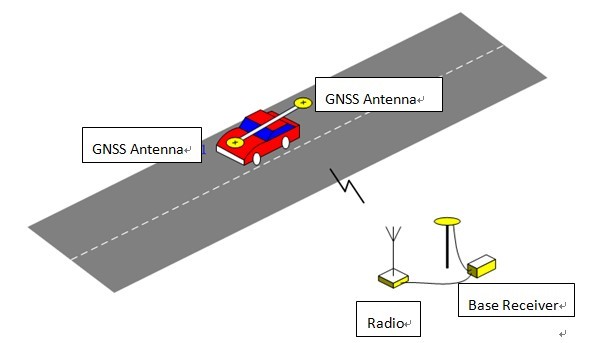
The system uses the real-time kinematic (RTK) method to establish the accurate heading and position of the car, with a ComNav M600 GNSS receiver. A base station sends differential data to a rover installed on the car. With the help of 3G or Wi-Fi, the real-time data is transmitted to the control center. Examiners can then can judge whether the car is in the right area. Both the trainee and system will know the testing results without delay.
Surveying the testing place, marking the testing area, and measuring the car shape need to be done before the installation.
ComNav Technology Ltd. is a high-accuracy positioning solutions supplier that focuses on high-accuracy GNSS core technology R&D, manufacturing and marketing. ComNav is the first Chinese high-accuracy GNSS OEM board manufacturer and producer of a GPS+BeiDou OEM board.
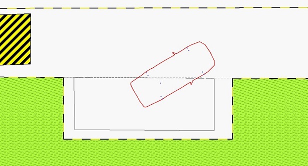
System diagram. Source ComNavSide parking test. Source ComNav
Ria Novosti reports that Russia will launch two GLONASS navigation satellites later this year to make up for the loss of three satellites in the recent Proton rocket explosion after launch from the Baikonur space center in Kazakhstan, according to a senior space industry official.
“We are planning to launch two satellites from the Plesetsk space center [in northern Russia] to replenish the GLONASS orbital grouping following the recent Proton-M accident,” said Nikolai Testoyedov, the head of the Information Satellite Systems (ISS) company, which manufactures satellites for the GLONASS project.
The first GLONASS is scheduled for launch in the beginning of September, and the second at the end of October, according to Testoyedov. The official added that both satellites will be launched on board the Soyuz carrier rockets, which has proven to be more reliable than ill-fated Protons.
A group of 29 GLONASS satellites is currently in orbit, with 24 spacecraft in operation, three spares, one in maintenance, and one in test flight phase, according to Russia’s space agency, Roscosmos.
Garmin International Inc. has announced HUD, the company’s first portable head-up display for smartphone navigation apps. With the HUD display, drivers can view navigation directions projected onto a transparent film on the windshield or an attached reflector lens. Garmin said by providing comprehensive road guidance at a glance and right within the driver’s line of sight, HUD can help increase safety and reduce driver distraction.
HUD receives navigation information from a Bluetooth-enabled smartphone running a Garmin StreetPilot or NAVIGON app.
“Head-up displays currently have their place in select high-end cars, but HUD makes this technology available as an aftermarket accessory for any vehicle, at an affordable price,” said Dan Bartel, Garmin vice president of worldwide sales. HUD has an MSRP of $129.99. Garmin StreetPilot and NAVIGON apps, starting at $29.99 for a regional map (NAVIGON U.S. Central, East or West), provide premium turn-by-turn navigation for smartphones, including onboard maps, lane guidance, speed limit warnings, real-time traffic, and other features.
HUD offers more navigation details than other portable head-up displays, yet presents them in a simplified way that doesn’t divert the driver’s attention from the road, Garmin said. The directions are easy to follow and allow drivers to navigate even the most challenging interchanges and traffic situations with ease. HUD displays turn arrows, distance to the next turn, current speed and speed limit, as well as estimated time of arrival. It even lets drivers know what lane to be in for the next maneuver and alerts them when they exceed the speed limit, the company said. HUD also warns users of potential traffic delays and upcoming safety camera locations. The crisp display automatically adjusts the brightness level so projections are clearly visible in direct sunlight or at night.
Complementing the visual display, spoken turn-by-turn directions are provided simultaneously by a compatible Garmin or Navigon app, either through the smartphone speaker or a Bluetooth-connected car stereo. Music streamed to the car stereo from the smartphone will automatically fade out for turn-by-turn voice prompts. HUD also continues to display navigation information while taking incoming calls.
Users can choose between displaying HUD navigation information on their windshield, with the included, transparent film, or on to the included reflector lens that attaches directly to HUD. The device pairs wirelessly with a compatible Bluetooth-enabled iPhone, Android phone or Windows Phone 8. An integrated USB port on the vehicle power/adapter cable makes it easy to charge the smartphone while driving, Garmin said.
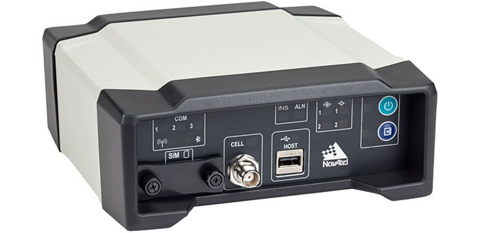
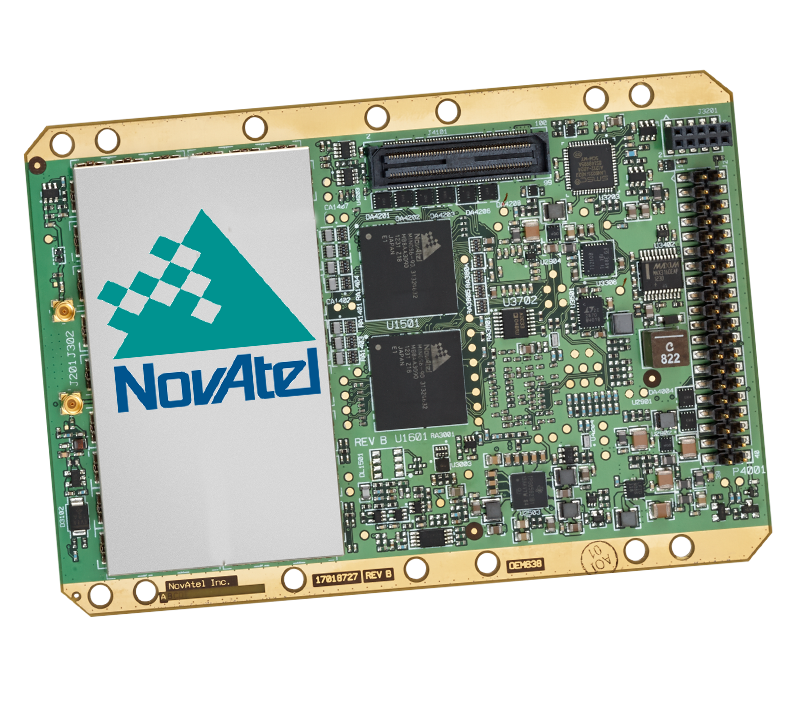
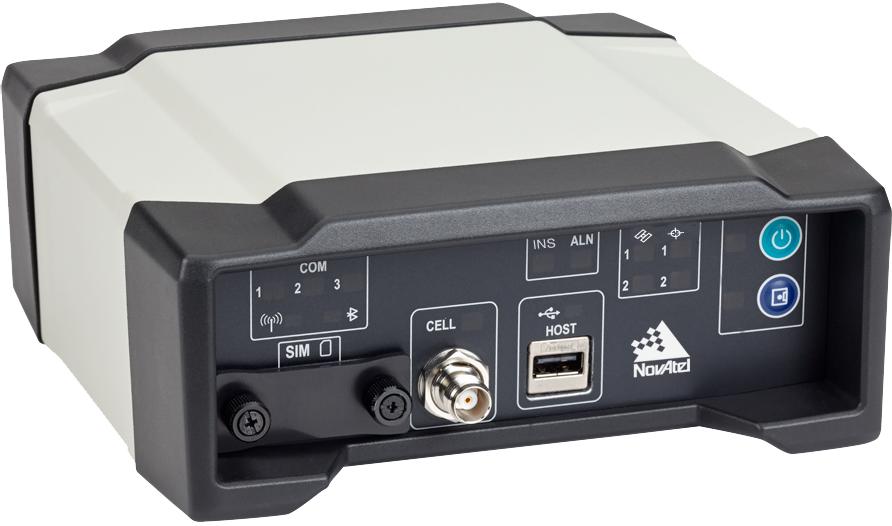
NovAtel has announced two new GNSS receivers: The OEM638 high precision receiver card and the ProPak6 enclosed receiver. The two products incorporate NovAtel’s most advanced GNSS technology, the company said.
Novatel OEM638. Photo: NovAtel
The most advanced card within NovAtel’s OEM6 GNSS receiver family, the OEM638 tracks all existing and planned constellations including GPS, BeiDou, GLONASS, Galileo and QZSS. By providing flexible positioning options, from standalone meter-level to AdVanceRTK centimeter-level accuracy, the OEM638 offers the flexibility to meet a wide range of positioning requirements. A powerful API, 4-GB on-board data storage, wide input voltage and a host of interface options simplifies integration, decreasing time to market and overall system costs, NovAtel said.
“With the addition of the OEM638 GNSS receiver card, NovAtel’s OEM6 product line offers an even wider range of positioning options on our standardized technology platform. With three compact form factors to choose from, the OEM6 product line gives us the ability to meet the unique size, weight and performance requirements of our customers,” said Jason Hamilton, director of marketing for NovAtel.
The ProPak6 is NovAtel’s most sophisticated GNSS enclosure product, offering meter-level to centimeter-level positioning in a rugged, water resistant IP67 housing. Standardized software and hardware connections, including multiple RS-232/RS-422 serial ports, CAN Bus, USB host and device, as well as Bluetooth, Wi-Fi, and optional cellular radio, speeds time to market and maximizes user capabilities, the company said. The ProPak6 is designed for reference station, timing, and general position applications.
NovAtel ProPak6. Photo: NovAtel
“Our ProPak6 provides a powerful enclosure option for integrators looking for positioning flexibility, multiple communication options and Ethernet support for remote configuration and access of data logs,” Hamilton said. “It was designed to simplify the integration process, by accelerating time to market and ensuring maximum return on investment. ”
The OEM638 and ProPak6 will be available to order July 26, with shipments beginning in August.
Proper management of large volumes of fluid has become a necessity as hydraulic fracturing has increased throughout North America. Creating the most effective fluid handling solution involves environmental, cost and project timeline considerations.
Select Energy Services, LLC, has launched AquaView, a suite of services that efficiently monitor water at various stages of the project through real-time, wireless technology. AquaView’s instant monitoring capabilities allow Select to respond immediately to on-site issues before emergencies arise.
AquaView capabilities include pit and reservoir hydrographic surveys utilizing SONAR remote control and GPS real-time data; data delivered to a secure portal offering current and historical data; real-time water quality reporting; and mapping and geographic information systems (GIS) support. The system can transmit the data with enabled access through computers, smartphones, tablets and text messages.
“This new technology is changing the way our industry does business,” said John Schmitz, Select Energy Services CEO. “AquaView will reduce down time and assist in the maintenance of completion schedules, essentially removing the need for traditional water tracking and measurement systems.”
Select’s team is capable of water transfer, containment assembly, water fill and complete removal or disposal.
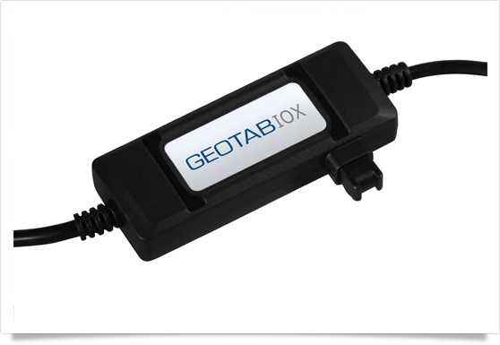
Geotab has launched a telematics Near Field Communications (NFC) Driver ID solution using an Input-Output-Expander (IOX) that allows for simultaneous connections and communications to occur with multiple devices, such as Garmin, Iridium, and HOS.
As an addition to its comprehensive fleet management platform, the technology will now help managers keep better track of each driver’s productivity and on-road safety — no matter which vehicle they are in, Geotab said.
With one touch of the NFC fob, vehicle operators can quickly, easily, and securely transfer their driver identification information to the cloud. Since Geotab’s GO6 device allows for multiple plug-and-play connections, the NFC Driver ID solution can be setup in minutes, the company said. Associating drivers with the vehicles they are in also allows for the software to generate driver-based score reports.
“The newly launched NFC Driver ID is a telematics industry game-changer that provides a reliable and accurate solution for businesses which pool their vehicles,” said Colin Sutherland, Geotab VP.
“NFC is seeing rapid application expansion across smartphones, tablets, and laptops. We fully expect to leverage this technology for future applications,” added Neil Cawse, Geotab CEO.
Although Geotab is launching a new Driver ID solution based on NFC, Geotab’s web-based software, MyGeotab, has been reporting both driver and vehicle summary value reports for over 10 years. The NFC Driver ID solution is now available for purchase through Geotab’s extensive Authorized Reseller network.
Rohde & Schwarz provides developers of satellite-based navigation instruments with a global navigation satellite system (GNSS) simulator, which runs on the R&S SMBV100A vector signal generator. The new R&S SMBV-K101 option allows developers in the automotive and wireless communications industries, for example, to test GNSS receivers for specific effects such as obscuration and multipath propagation. Buildings, tunnels and bridges as well as reflections from concrete and glass surfaces affect the GNSS signal, regardless of whether the receiver is stationary or in motion. This option makes it easy to configure these kinds of scenarios.
If the GNSS receiver of a navigation instrument or smartphone is located inside a vehicle, testing must also take into account the obscuring effect of the vehicle’s metal body. The R&S SMBV-K102 option can simulate this obscuration and, if required, also the additional antenna pattern.
In addition to test scenarios for A-GPS, smartphone developers also have the Assisted Galileo (R&S SMBV-K67) and Assisted GLONASS (R&S SMBV-K95) options at their disposal. (Mobile radio networks transmit location-specific information to wireless devices via A-GNSS so that they can determine the current position faster.)
In many cases, navigation instruments handle signals of digital communications standards other than GNSS. As the first GNSS simulator of its kind on the market, the R&S SMBV100A also supports these standards. Now, manufacturers of mobile phones and car radios with integrated GNSS receivers need just one signal generator to test multiple functionalities. The R&S SMBV100A can also be used to perform interference tests on the DUT.
Users in the aerospace and defense industry can use the R&S SMBV-K103 option to simulate the relative position of a flying object as well as its rotation at a rotation rate of up to 400 Hz. This allows developers to perform lab tests to determine how a flying object’s different positions, the ground reflection of GNSS signals and rotary movements affect reception quality.
The GNSS simulator in the R&S SMBV100A uses up to 24 satellites to generate signals in realtime for GPS with civilian C/A code and military P code as well as for Glonass and Galileo in different constellations. In just a few steps, users can define their own scenarios for testing their GNSS receivers under various conditions. The R&S SMBV100A is the only GNSS simulator on the market that does not require an external PC. As a result, it is easier to automate, and test setup is simple.
The new options for the GNSS simulator in the R&S SMBV100A are now available from Rohde & Schwarz.
Lockheed Martin has completed and is preparing to install the navigation, communication, and hosted payload antenna assemblies for the first satellite of the next-generation GPS III.
Seven antenna assemblies, produced at Lockheed Martin’s Newtown, Pennsylania, facility were delivered to the company’s GPS III Processing Facility (GPF) near Denver, Colorado, on June 14. The antennas will be installed on the first GPS III space vehicle (SV01), which Lockheed Martin will deliver to the U.S. Air Force on schedule, “flight-ready,” in 2014.
The new antennas for GPS III SV01 will provide the satellite’s capability to send and/or receive data for Earth-coverage and military Earth-coverage navigation; a UHF crosslink for inter-satellite data transfer; telemetry, tracking and control for satellite-ground communications; and data acquisition and communication for the nuclear detection system hosted payload. The antenna designs enable three to eight times greater anti-jamming signal power to be broadcast to military users across the globe when compared to previous GPS generations.
“These antennas on the next generation of GPS III satellites will transmit data utilized by more than one billion users with navigation, positioning and timing needs,” explained Keoki Jackson, vice president of Lockheed Martin’s Navigation Systems mission area. “We have become reliant on GPS for providing signals that affect everything from cell phones and wristwatches, to shipping containers and commercial air traffic, to ATMs and financial transactions worldwide.”
GPS III is a critically important program for the Air Force, affordably replacing aging GPS satellites in orbit, while improving capability to meet the evolving demands of military, commercial and civilian users. GPS III satellites will deliver three times better accuracy, include enhancements which extend spacecraft life 25 percent further than the prior GPS block, and a new civil signal designed to be interoperable with international global navigation satellite systems.
The production of the first GPS III satellite continues on schedule. Recent testing of the SV 01 bus — the portion of the space vehicle that carries mission payloads and hosts them in orbit — assured that all bus subsystems are functioning normally and that they are ready for final integration with the satellite’s navigation payload.
This milestone follows February’s successful initial power on of the SV01 spacecraft bus, which demonstrated the electrical-mechanical integration, validated the satellite’s interfaces and led the way for functional electrical hardware-software integration testing.
Lockheed Martin is under contract for production of the first four GPS III satellites (SV01-04), and has received advanced procurement funding for long-lead components for the fifth, sixth, seventh and eighth satellites (SV05-08).
The GPS III team is led by the Global Positioning Systems Directorate at the U.S. Air Force Space and Missile Systems Center. Lockheed Martin is the GPS III prime contractor with teammates ITT Exelis, General Dynamics, Infinity Systems Engineering, Honeywell, ATK and other subcontractors. Air Force Space Command’s 2nd Space Operations Squadron (2SOPS), based at Schriever Air Force Base, Colorado, manages and operates the GPS constellation for both civil and military users.
Photo: TrimbleTrimble has introduced the Trimble MX2 mobile spatial imaging data capture system. The MX2 extends the capabilities of geospatial professionals, allowing them to safely and effectively address complex projects by collecting spatial data from a mobile scanning platform, the company said. The Trimble MX2 provides a versatile and complimentary addition to Trimble’s family of mobile data capture systems.
Designed for mapping, surveying and engineering environments, the MX2 is rugged, lightweight and portable. It is also easily deployed and redeployed on projects similar to conventional surveying equipment. A precise laser scanner, along with an embedded Trimble-Applanix GNSS/Inertial positioning system, allows geospatial professionals to create the point cloud accuracies necessary for many spatial imaging projects. Accompanied by Trimble Trident software to capture, process and analyze point data, the MX2 offers a ready-to-use workflow for surveyors and professionals in mapping, engineering, planning, oil and gas, utilities, mining, environmental, public safety and more. The system is available in single and dual-laser versions.
In conjunction with the MX2 system, Trimble also announced new features for its Trident Software 6.0. The software developed for rapid transformation of point clouds and imagery into geospatial intelligence has been significantly enhanced to provide a scalable software suite for a wide range of users. Additions include the incorporation of direct trajectory import and the Trimble Coordinate System Manager. The Trimble Trident software suite is ideal for the analysis of mobile laser scanner data and geo-referenced imagery.
“The Trimble MX2 provides survey companies with the opportunity to enter the world of mobile scanning at a time when it is becoming a desired service within their solution portfolios,” said Katherine Sandford, general manager of Trimble’s Imaging Division. “The MX2 offers a simple and highly productive mobile data collection capability and a 3D point cloud workflow for a wide range of users.”
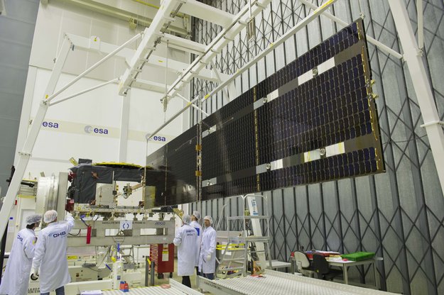
In the photo above, deployment of the solar wings on the latest Galileo satellite is being checked at the European Space Agency’s technical hub in the Netherlands. The navigation satellite’s pair of 1 x 5-meter solar wings, carrying more than 2,500 gallium arsenide solar cells, will power the satellite during its 12-year working life.
With the first four Galileo In-Orbit Validation satellites already in orbit, this is the first of the rest of Europe’s satnav constellation.
A counterweighted rig supports the deployment; otherwise the delicate fold-out wings — designed for the weightlessness of space — would crumple under the pull of Earth gravity.
These Full Operational Capability satellites provide the same operational services as their predecessors, but they are built by a new industrial team: OHB in Bremen, Germany, built the satellites with Surrey Satellite Technology Ltd. in Guildford, UK, contributing the navigation payloads.
This satellite is the first of 22 ordered from OHB. It arrived at ESA’s ESTEC research and technical centre in Noordwijk in May to begin a rigorous campaign of testing in simulated launch and space conditions, guaranteeing its readiness for launch.
The first test performed on the satellite once it came out of its container was a System Compatibility Test Campaign, linking it up with the Galileo Control Centres in Germany and Italy and ground user receivers as if it was already in orbit.
Galileo’s wings with 30%-efficient solar cells were fitted at the end of June, supplied by Dutch Space in nearby Leiden. Future satellites will have their wings fitted at OHB before coming to ESTEC, but this first satellite offered an opportunity for Dutch Space engineers to train their OHB counterparts in the procedure.
“The 22 Galileo FOC satellites are being produced and tested on a batch production basis, which is a new way of working for ESA,” explained Jean-Claude Chiarini, overseeing FOC satellite procurement for the Agency. “The concept is really to set up a steady flow of satellites from OHB to ESTEC and then Kourou for launch over the next few years.
“The first four will undergo full validation testing, checking the underlying design is correct, in order to support the formal ground qualification of the design, with subsequent FOC satellites then going through acceptance testing, concentrating on checking workmanship,” Chiarini said.
The FOC satellites, while resembling their predecessors, are designed with this production concept in mind. Hinged modules offer easy access to internal subsystems for rapid repair or potential replacement of units.
The next satellite is due to arrive around the start of August. The battery of simulations includes vibration and acoustic testing, as well as thermal-vacuum testing — submitting them to the airlessness and temperature extremes of space for weeks at a time.
Following the July 1 launch of the Indian Regional Navigation Satellite System 1A satellite, five orbit maneuvers were to be conducted by the master control facility to position the satellite in its circular inclined geosynchronous orbit (IGSO) with an equator crossing at 55 degrees east longitude.
Reports indicate that orbit raising maneuvers have been completed with a fifth apogee motor firing on July 6 at 16:57 IST or 11:27 UTC. All the spacecraft subsystems have been evaluated and are functioning normally.
The satellite was reported to be in IGSO with a 27 degree inclination at 44 degrees east longitude.
NORAD/JSpOC has released a two-line element set for the IGSO of the satellite with an epoch of a few days ago:
This data indicates that the sub-satellite equator crossing was about 47 degrees east longitude at the reference epoch. The satellite orbit equator crossing is drifting eastwards and should reach 55 degrees east longitude by about July 14.
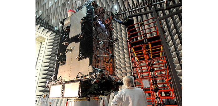
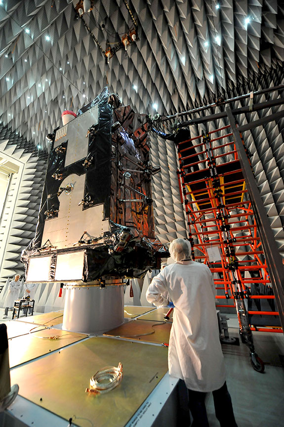
Lockheed Martin’s GPS III Non-Flight Satellite Testbed (GNST) has successfully completed a series of high-fidelity pathfinding events which validate the process and facility for vehicle integration checkout, as well as signals interference testing, that the next-generation satellites of GPS III will go through before delivery for launch.
An innovative investment by U.S. Air Force under the original GPS III development contract, the GNST is a full-sized GPS III satellite prototype which has helped to identify and resolve development issues prior to integration and test of the first GPS III space vehicle (SV 1). Following the Air Force’s rigorous “back-to-basics” acquisition approach, the GNST has gone through the development, test and production process for the GPS III program first, significantly reducing risk for the flight vehicles, improving production predictability, increasing mission assurance and lowering overall program costs.
During this latest milestone, the GNST successfully completed thermal vacuum (T-Vac) chamber trail blazing, demonstrating facility, mechanical and electrical ground equipment integration, and ran a series of vehicle integration test procedures. The GNST also completed Passive Intermodulation (PIM) and Electromagnetic Compatibility (EMC) testing, which assures that multiple high-powered signals generated from the satellite’s navigation downlink transmissions, or transmitted from the hosted nuclear detection system payload on the satellite, do not interfere with each other or themselves.
“As the GNST serves as a pathfinder for the GPS III program, its successful completion of this testing validates that development risks have been retired and our engineering and technology is sound for the flight vehicles being built,” explained Keoki Jackson, vice president for Lockheed Martin’s Navigation Systems mission area.
The GNST is now being prepared for shipment to Cape Canaveral U.S. Air Force Station, Florida, for more risk reduction activities related to satellite launch.
The GPS III prototype in an anechoic chamber where it completed Passive Intermodulation (PIM) and Electromagnetic Compatibility (EMC) testing at Lockheed Martin’s GPS III Processing Facility outside of Denver, Colorado. Photo: Lockheed Martin’s Navigation Systems
GPS III is a critically important program for the Air Force, affordably replacing aging GPS satellites in orbit, while improving capability to meet the evolving demands of military, commercial and civilian users. GPS III satellites will deliver three times better accuracy and — to outpace growing global threats that could disrupt GPS service — up to eight times improved anti-jamming signal power for additional resiliency. The GPS III will also include enhancements adding to the spacecraft’s design life and a new civil signal designed to be interoperable with international global navigation satellite systems.
Lockheed Martin is currently under contract for production of the first four GPS III satellites (SV 1-4), and has receivedadvanced procurement funding for long-lead components for the fifth, sixth, seventh and eighth satellites (SV 5-8).
The Lockheed Martin team remains on track to deliver the first GPS III satellite, with its enhanced capabilities over current orbiting systems, for launch availability in 2014.
The GPS III team is led by the Global Positioning Systems Directorateat the U.S. Air Force Space and Missile Systems Center. Lockheed Martin is the GPS III prime contractor with teammates ITT Exelis, General Dynamics, Infinity Systems Engineering, Honeywell, ATK and other subcontractors. Air Force Space Command’s 2nd Space Operations Squadron (2SOPS), based at Schriever Air Force Base, Colorado, manages and operates the GPS constellation for both civil and military users.


![Trimble-MX2-Spatial-Imaging-System[1].jpg Photo: Trimble](https://stage.globalpositioningnews.com/wp-content/uploads/2013/07/Trimble-MX2-Spatial-Imaging-System1.jpg.jpg)