Author: GPS World Staff

  • Zimmerman Tracked with GPS While out on Bond

    GPS tracking devices have been used for several years by law enforcement professionals. In the high-profile case of George Zimmerman, his whereabouts while out on bond are being continuously monitored by the Seminole County Sheriff’s Office, though he has gone into hiding.

    After Zimmerman was released on bond on Monday from a Florida jail, the ankle-bracelet GPS device pinpoints his location and will alert authorities if he drifts even a few feet away from where he is allowed, according to the Associated Press via Yahoo! News. Zimmerman is charged with second-degree murder in the killing of 17-year-old Trayvon Martin. He must pay an $8-a-day fee to use the device, which is often used to track people charged in domestic violence cases.

    Seminole County Sheriff’s officials are offering few details on how Zimmerman will be specifically monitored, other than to say the GPS device he is wearing has the same 24/7 capabilities it uses to track accused domestic violence offenders. Zimmerman may be residing outside of Florida for safety reasons, but the device is capable of monitoring anywhere in the U.S.

    Computer software synced to the device enables “inclusionary zones” to establish where a person can go, AP reported. It also can report whether the user is being compliant with release conditions like curfews. Zimmerman has been asked to observe a curfew between 7 p.m. and 6 a.m.

    The monitoring program has been in use since 2003 in Seminole, according to the sheriff’s office. In 2009, using the devices saved $950,000 by keeping people out of jail, the office said.

  • Taoglas Offers Dominator Antenna with Wider GLONASS Bandwith

    Taoglas Offers Dominator Antenna with Wider GLONASS Bandwith


    Photo: Taoglas

    Taoglas is launching the AA.16X Dominator series of antennas, which have a wider bandwidth to cover the GLONASS operating frequencies up to 1610 MHz, a good axial ratio, and a double resonance design for optimum reception at the centre frequencies. The company will showcase its line of antennas at CTIA in New Orleans May 8-10.

    Taoglas’ GPS antennas are being used in the field by many different M2M solution providers including tracking, telematics, and GPS manufacturers, the company said.

    The AA.161 Dominator is a magnetic mount GPS-GLONASS IP67, external antenna incorporating a 35-millimeter ceramic patch. It is a wide-band active patch antenna product with a large integral ground that delivers a gain up to 35 dB. With the Dominator antenna series, Taoglas has a comprehensive range of GPS-GLONASS active embedded antennas (AGGP series) and passive embedded (CGGP) antennas for automotive first-tier TS16949 and after-market applications.

    “In the coming months, for the first time the true availability of GPS and GLONASS satellites along with the latest generation of GNSS receivers are going to dramatically change the performance of M2M location devices,” said Ronan Quinlan, Director Taoglas. “With close to double the amount of satellites to draw from compared to a stand-alone GPS constellation, we are now going to see quicker time to first fixes with accuracy improving from meters to sub one meter. The ability to view and lock on four or more satellites in traditionally difficult reception areas such as urban canyons, city centers or locations with restricted views of the horizon, will give M2M manufacturers the ability to triangulate and pinpoint locations with greater accuracy and with quicker time to first fix.”

    Taoglas’ new Dominator antennas have been rigorously tested and pre-approved by the GNNS receiver companies worldwide and have been shown to display higher and more consistent gain in comparison to competing antennas, the company claimed. Two key components have been engineered from scratch for the Dominator series, a wide-band front-end SAW filter (critical to prevent out of band noise entering on both GPS and GLONASS degrading the signal) and a high-gain 35-mm patch.

  • Geosoft 2012 Software Released

    Geosoft announced the availability of its 2012 Software Release, including updates to Oasis montaj, Target, Target for ArcGIS and GM-SYS Modelling software, and the new release of Geosoft VOXI Earth Modelling, a geophysical inversion software service that generates 3D voxel models from airborne or ground gravity and magnetic data. The 2012 release includes major 2D and 3D workflow enhancements and new capabilities that deliver greater efficiency and flexibility for resource explorers and earth scientists exploring the earth’s subsurface.


    “Each year Geosoft has continued to make improvements in developing our software technology to support explorers challenged to visualize and analyze more complex structures, deeper under cover, within integrated interpretations,” says Louis Racic, Geosoft Product Director. “The 2D to 3D workflow is an important one to get right, and a particular challenge for geoscientists working across GIS and exploration software platforms. Bridging the gap between 2D and 3D is a key improvement area within our 2012 Software Release.”

    Release highlights

    According to the announcement, new capabilities and workflow improvements in the Geosoft 2012 Software Release help save time and provide greater flexibility when visualizing multidisciplinary geoscience data in 2D and 3D.

    Improved 2D to 3D workflows in Target for ArcGIS: The 2D to 3D workflow enhancements, include new display capabilities, and new section import and export options. Layers, such as interpretation layers from sections or plans can now be easily displayed in their correct geospatial orientation within your 3D view. 2D section interpretations can be exported to a 3D georeferenced file, such as shapefiles or DXF files, to be shared with other 3D applications. 3D vector files, such as open pit outlines, and wire frames can now be easily imported to multiple section and plan maps.

    3D Viewer improvements: Geosoft 3D gridding methods have been expanded to include IDW and direct gridding; these new methods better support the 3D gridding of a broad range of data types. Angled clipping of objects in 3D views provides the ability to clip parallel or perpendicular to dataset orientation or geological strike. Geoscientists can set a clipping plane that aligns with any direction chosen.

    Expanded GM-SYS 3D density model support: Voxels can be used to define the 3D density variation within GM-SYS 3D model layers. This provides more direct integration with 3D seismic data as the generated density cubes may be used directly in the GM-SYS model.

    BING Maps imagery: Geoscientists can now add satellite imagery to their basemaps by connecting to the Bing Maps online data source. This is a useful, additional data layer which provides geographic context to maps.

    VOXI Earth Modelling

    Geosoft VOXI Earth Modelling is a new geophysical inversion software service that generates 3D voxel models from airborne, ground gravity and magnetic data. VOXI Earth Modelling is accessiblewithin Geosoft Oasis montaj and uses the power of cloud computing to rapidly invert large exploration datasets. More information on VOXI Earth Modelling is available at www.geosoft.com/voxi.

    Release availability

    Online installation of the Geosoft 2012 Software Releaseis available within Geosoft software and from the Downloads page within the Geosoft online support centre. Information on how to request an update DVD is available in the Geosoft Support Knowledge Base.

  • Lockheed to Lose Fee on GPS III Satellites from Cost Overrun

    The U.S. Air Force says defense contractor Lockheed Martin will lose its entire fee of about $70 million to defray an 18 percent cost overrun on the first of its newly designed GPS III satellites, the Washington Post reported.

    Lockheed had estimated that it would cost $1.5 billion to develop, test and build the first two GPS III satellites, but Air Force spokeswoman Vicki Stein said the cost had risen to $1.62 billion.

    The new GPS III satellites are designed to deliver more accuracy, an anti-jamming capability and a civilian signal that can operate with Europe’s Galileo system.

  • First Payload Ready for Next Batch of Galileo Satellites


    These payload panels for the first Galileo Full Operational Capability satellite are undergoing
    final testing in the Assembly Integration Test hall at Surrey Satellite Technology Ltd. in
    Guildford, UK, in April 2012 before being boxed up for shipment to prime contractor OHB in Germany.

    The first of 14 Galileo Full Operational Capability (FOC) navigation payloads has been shipped from Surrey Satellite Technology Ltd. in the United Kingdom to prime contractor OHB System AG in Bremen, Germany, according to the European Space Agency. The payload, which provides Galileo’s precision positioning measurements and services to users, will then be added to the waiting satellite platform.

    “The payload for the fifth satellite in the Galileo constellation is ready,” said Didier Faivre, ESA’s director of the Galileo Programme and Navigation-related Activities. “While the next two satellites to be launched are currently undergoing testing, the next ones are being built. Another important step forward for the programme was made today.”

    The SSTL payload is engineered to provide all Galileo navigation services, and is based on European atomic clocks, navigation signal generators, high-power amplifiers and antennas. “The delivery of our first Galileo payload is an important milestone towards achieving full satellite qualification at the end of the year,” commented Matt Perkins, SSTL CEO.

    The first two Galileo satellites entered orbit October 21, 2011, with two more due at the end of this summer. These initial satellites carry payloads built by Astrium UK in Portsmouth, with Thales Alenia Space in Italy integrating them with their satellite platforms.

    The new satellites are the follow-up batch of Galileo satellites, planned to begin launches in 2014. Once all 14 are in orbit, the 18-satellite Galileo constellation will achieve Initial Operational Capability and will be able to provide initial navigation services — the full range of services will be available once all 30 satellites are in place in 2018.

    In addition to these first 14 FOC satellites, the OHB–SSTL consortium was awarded a contract to build a further eight satellites for the Galileo system in February this year.

  • Trimble Introduces Ultra Rugged GNSS Smart Antenna for Heavy Civil Construction

    Trimble Introduces Ultra Rugged GNSS Smart Antenna for Heavy Civil Construction

    Photo: Trimble
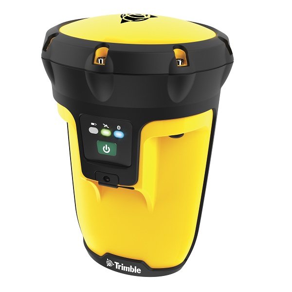
Trimble has introduced the ultra-rugged Trimble SPS985 GNSS Smart Antenna for performing high-accuracy construction site measurements. The new smart antenna is made of a specially developed alloy that combines unprecedented strength and durability into a compact form to withstand the daily abuse of construction work, Trimble said.

    With its enhanced internal shock isolation, the SPS985 is suited for high-vibration use on an all-terrain vehicle (ATV) or supervisor truck. User-friendly features such as a quick release connector and smartphone configuration make it easy to deploy and use as a base station or rover, mounted on a range pole or truck roof, Trimble said. Advanced communications including Wi-Fi, Bluetooth, and optional wideband radio integrate the receiver into the connected construction site.

    “The Trimble SPS985 was engineered to be the toughest, smallest and easiest to use GNSS receiver we’ve ever built,” said Chuck Maniscalco, director of engineering for Trimble. “We listened to customer feedback and built the housing 50 percent stronger than any previous Trimble antenna, because we wanted it to perform ideally under extreme conditions — such as being dropped, tossed in a truck bed, rained on and otherwise abused in the construction setting. Contractors will likely never treat their SPS985 antennas as harshly as the Trimble engineering team has, but we intended to take rugged GNSS to the next level and we certainly achieved that.”

    When used as a rover, the SPS985 allows for maximum flexibility for use on a wide variety of site measurement tasks. For initial site reconnaissance, it can be deployed with satellite-delivered GNSS corrections without a base station. For higher accuracy site measurements, it can receive Real-Time Kinematic (RTK) corrections via the internal wideband radio, Wi-Fi or the Internet.

    An SPS985 unit can be easily moved from carrying case to range pole, tripod, t-bar, or vehicle with a single click — making it faster to begin working and allowing for more flexibility of operation techniques. For example, a grade checker can mount the SPS985 to an ATV and easily conduct site topos, check as-builts and verify road centerlines where it is not easy or safe to walk with a range pole. Extending its productivity, the same unit can then be mounted on the roof of a supervisor’s truck roof to collect and manage progress data.

    As a base station, the SPS985 incorporates Wi-Fi communications for small site projects and optional wideband radio for long-range operations on large projects. Designed for ease of use, it will automatically establish a radio or Wi-Fi connection and transmit RTK corrections to another rover or machine control system, Trimble said. Construction crews can spend more time doing the work and less time setting up and maintaining the equipment.

    As a component of the Trimble Connected Site solutions portfolio, the SPS985 also offers connectivity features that save administrative time and increase working productivity. When used with a Connected Controller such as the Trimble TSC3 or Trimble Tablet, job crews can connect to a mobile hotspot in the site trailer or supervisor’s truck and receive GNSS corrections via VRS network or Trimble Internet Base Station (IBSS). They can also save considerable time by wirelessly synchronizing progress data and as-built information to the job supervisor or head office and receiving updated design information back without ever leaving the job site.

    Quick start technology and the ability to set up and configure the receiver using a smartphone increases flexibility and eliminates the need to use a more expensive controller for daily setup. The Trimble Web UI is optimized for small screen devices, allowing a GNSS manager to monitor base station performance, availability and configuration without visiting the job site to set up each day.

    The new Trimble SPS985 GNSS Smart Antenna is available now through Trimble’s worldwide SITECH Technology Dealer Channel.

  • Urban Airship Partners with Meridian for Indoor Location Targeted Mobile Messaging


    Urban Airship has announced a strategic partnership with Meridian for indoor location targeted mobile messaging. Meridian’s technology will enable Urban Airship customers with physical locations to reach people at the point of decision with indoor location targeting. Together, the companies’ solutions offer broad capabilities for location-targeted messaging, from quickly identifying audiences with certain behaviors or preferences in regions down to a neighborhood level, to delivering pinpoint targeted messages inside buildings.

    Since partnering with Cisco to build an “indoor GPS” app for the American Museum of Natural History, Meridian has helped many different types of venues offer apps with campus and building-specific search functionality, multimedia, turn-by-turn directions, and push messaging powered by Urban Airship. Urban Airship Segments enables marketers to segment mobile audiences by location, time, context and preferences to improve the relevancy and targeting of messages and offers. Together, the organizations offer capabilities to utilize context and location to drive mobile audiences to and through physical locations.

  • Qualcomm Announces Commercial Availability of MCP50 for Fleet Management


    Qualcomm announced the commercial availability of the Mobile Computing Platform 50 (MCP50). For fleets of all sizes, the fleet management solution helps transportation companies meet safety and regulatory compliance requirements to manage their business operations, Qualcomm said. Qualcomm also launched flexible new monthly pricing plans.

    “We are committed to helping fleets succeed and grow as they adapt to new industry demands and regulations,” said Norm Ellis of Qualcomm Enterprise Services. “With more than 150 private and for-hire fleets of all sizes already committed to adopting the MCP50, we are pleased that our industry-leading fleet management applications are now more accessible than ever to help fleets address a broad range of operational challenges, including safety, compliance, productivity and fuel efficiency.”

    MCP50 delivers applications to meet the core operational needs, including safety and compliance requirements, such as FMCSA’s HOS regulations and CSA program. Applications include: Qualcomm Hours of Service, CSA Safety Performance Service, Critical Event Reporting, CoPilot Truck In-Cab Navigation provided by ALK Technologies, Performance Monitoring with Fuel Manager, Analytics Manager and Vehicle Inspection Report. Other Qualcomm applications planned for future releases of the MCP50 include Circle of Service Workflow, Trip Manager and Vehicle Maintenance.

    MCP50 is available for $799 SRP through local dealers and resellers that are part of the Pana-Pacific distribution network or directly from Qualcomm Enterprise Services. Qualcomm Enterprise Services also offers six different monthly service pricing plans, starting at $19.95 per month.

  • SpectraTime Awarded Contract to Improve Rubidium Atomic Frequency Standards

    SpectraTime, a business of the Orolia Group, today announced it has been awarded a 1M€ contract to improve rubidium atomic frequency standards (RAFS) as part of the European Global Navigation Satellite System Evolution Program.

    Pascal Rochat, SpectraTime Managing director and founder, said, “We are pleased to continue to push the performance limits of space-based precision clock technologies to enable new applications in the future. The knowledge gained through this investigation will be invaluable. As a result we expect all our customers to benefit from this work as our commercial products are derived from the same design and manufacturing process as our space-based clocks.”

    Atomic clock standards are critical for high-precision applications such as global navigation satellite systems. While the current Rubidium-based atomic frequency standards meet the requirements of current systems, future applications will demand a higher level of performance for short-term and long-term stability, SpectraTime said. Recognizing the need to continue to extend this technology to new performance levels, the European Space Agency (ESA) has turned to SpectraTime, the existing supplier of atomic clocks for the Galileo satellites and other GNSS satellite systems.

    “The award of this new development contract illustrates the European Space Agency’s confidence in our technology and confirms our global leadership role in the supply of precision atomic clocks for navigation applications,” said Jean-Yves Courtois, CEO of the Orolia Group. “Not only will this ensure our competitiveness into the future for the European space market, it will benefit our entire portfolio of programs and customers and secures our leading position in navigation applications.”

    The contract is for a detailed investigation of the current design, manufacturing, assembly and test techniques for fully integrated rubidium clocks in order to achieve a new standard for space within two years. It adds to SpectraTime’s wide portfolio of space-based precision timing projects.


  • Rugged Trimble Pro Series GNSS Receivers Provide Flexibility for GIS and Mobile Mapping

    Pro20Series20Cover20View Trimble
    Trimble

    Trimble introduced today the next-generation of its Trimble GPS Pathfinder family — the Trimble Pro 6H and Pro 6T receivers for GIS and mobile mapping. The Trimble Pro series with advanced features allows mobile workers to configure a solution for a wide range of applications, delivering flexibility in professional GIS data collection, Trimble said. The series offers a new streamlined form-factor and dramatic productivity improvements in difficult GNSS environments with Trimble Floodlight technology.

    The modular Trimble Pro series receiver gives users the flexibility to choose their setup configurations:

    • Optimized for use with Trimble data collection devices such as the Trimble Juno or Nomad G series handhelds, or Yuma tablet computer, the Trimble Pro series can also be used with other tablets and handhelds with NMEA output.
    • Real-time or postprocessed GIS workflows.
    • The receiver can be deployed in a backpack, on a pole or mounted on a vehicle.
    • Two models are available: the Trimble Pro 6H delivers decimeter accuracy, while the Pro 6T is the submeter model for standard GIS applications.

    With the availability of the new Pro series receivers, data collection professionals now have access to the productivity-enhancements of Floodlight technology in both integrated and modular configurations,” said Daniel Wallace, general manager of Trimble’s GIS Data Collection Division. “While some prefer the convenience of an integrated, all-in-one handheld, others will appreciate the Pro series’ flexibility to choose from a range of data collection devices such as a high-resolution tablet or lightweight Trimble Juno.”

    Trimble Floodlight technology allows users to collect decimeter accuracy data in tough GNSS environments, Trimble said. Buildings and trees can cause satellite shadow and limit the environments where high-accuracy GNSS data collection can be performed. Trimble Floodlight technology combines a range of techniques to increase the availability of positions and boost accuracy in areas affected by satellite shadow. Using Floodlight technology, the Pro series can keep teams productive without compromising on accuracy. Users can work with fewer disruptions and ensure better data, faster data collection and higher field efficiency.

    Trimble Pro series receivers are rugged and built to withstand the rigors of long hours in tough outdoor conditions, yet optimized for high-accuracy GIS data collection workflows, Trimble said. For applications such as utilities inspections and timber stand valuations, Trimble Pro receivers provide long battery life and tough construction for dependable service over the course of rigorous data-collection projects.

    With its IP65 rating, the receivers offer reliable operation, even after prolonged exposure to water and dust, Trimble said. An integrated antenna reduces the complexity of the system for fast setup and swift data collection campaigns. Field workers can be up and running with minimal training, saving time and money. Combined with a Trimble handheld solution and Trimble TerraSync software, the complete system provides dedicated field workflows to simplify data collection and improve integration with the GIS for total workflow improvements.

    The new Trimble Pro 6H and 6T receivers are available from Trimble’s worldwide Mapping & GIS authorized distribution channel.

  • Simulating the Future

    Speakers from several leading simulator companies will share their views on the importance and intricacies of simulator testing, in the increasingly complex environment of multiple modernized GNSS signals. The webinar “Simulating the Future: How to Cope with Expanding GNSS” is slated for Thursday, April 19, and will feature these guest speakers:

    • Mark Sampson, LabSat Product Manager, RaceLogic (shown in photo);
    • John Fischer, Chief Technology Officer, Spectracom;
    • Mark Holbrow, Chief Engineer (Positioning Technology), Spirent Communications;
    • Markus Lörner, Product Manager, Rohde & Schwarz.

    Below are two sample slides from the speakers’ presentations, to give an idea of the level of technical discussion.  The webinar will be of profitable interest to all GNSS product designers, managers, manufacturers, distributors, and users, as well as similar roles in wireless, LBS, aviation and automobiles, and other associated fields using or seeking to use positioning, navigation, and timing.

    Register for the webinar here.


  • TRUSTe Introduces Mobile Advertising Privacy Management Solution

    TRUSTe has introduced TRUSTed Mobile Ads, a unified mobile advertising privacy management solution. TRUSTed Mobile Ads support mobile browsing and application privacy preferences across all platforms and devices. The solution addresses the evolving privacy compliance standards, growing consumer privacy concerns, and complicated technology requirements unique to the mobile ecosystem.

    Developed in partnership with mobile advertisers, publishers, networks and platforms, TRUSTed Mobile Ads provides an end-to-end privacy management solution that enables businesses to deploy advertising capabilities such as behavioral targeting, while providing consumers with transparency, choice, and control over the collection and use of their personal information, TRUSTe said. The solution builds upon TRUSTe’s web advertising privacy management solution, TRUSTed Ads, and its mobile privacy management solutions, TRUSTed Apps, TRUSTed Mobile Websites, and the recently released Free Mobile Privacy Policy Service.

    “The need for a standardized cross-platform approach to mobile privacy is essential to maximize mobile advertising opportunities, address growing regulatory concerns and build trust for consumers,” said Chris Babel of TRUSTe. “With TRUSTed Mobile Ads, TRUSTe wants to bring our success as the largest DAA-approved online behavioral advertising compliance provider to the mobile ecosystem. With the support of our partners, we are fully committed to helping the industry take a proactive stance for mobile privacy compliance and consumer confidence.”