A link to the live event will be sent to you two hours before the event. Your personalized event URL will be automatically generated by the ON24 system. To ensure receipt of the email, please whitelist this email address by adding it to your contacts: [email protected].
This presentation will begin on at 1 p.m. EDT / 10 a.m. PST on Thursday, September 20, 2018.
Audience members may arrive 15 minutes prior to live time. If you have any questions, please contact event producer Grace Rybak at [email protected].
Once the next-generation GPS III satellites begin launching in December, a series of updates to the current ground control system from Lockheed Martin will help the U.S. Air Force gain early command and control of the new satellites for testing and operations.
In 2016 and 2017, the Air Force placed Lockheed Martin under two contracts, called GPS III Contingency Operations (COps) and M-code Early Use (MCEU), which directed the company to upgrade the existing Architecture Evolution Plan (AEP) Operational Control System (OCS), which operates today’s GPS constellation.
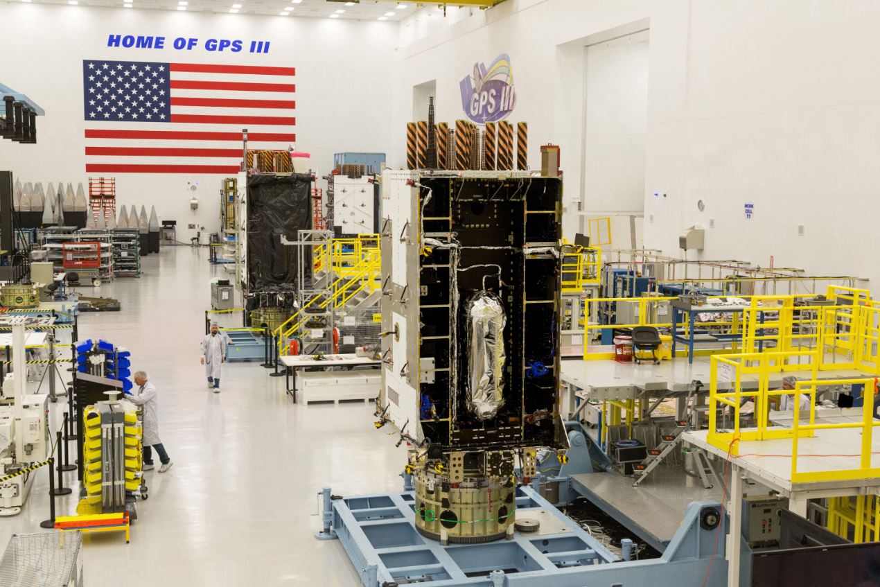
The fourth Lockheed Martin-built GPS Ill satellite is fully integrated. (Photo: Lockheed Martin)
These upgrades to the AEP OCS are intended to serve as gap fillers prior to the entire GPS constellation’s operational transition to the next-generation Operational Control System (OCX) Block 1, now in development.
In April, the Air Force approved Lockheed Martin’s critical design for MCEU, essentially providing a green light for the company to proceed with software development and systems engineering to deploy the M-code upgrade to the legacy AEP OCS.
The Air Force gave a similar nod to COps in November 2016. COps is now on schedule for delivery in May 2019 and MCEU is scheduled for delivery in January 2020.
“The Air Force declared the first GPS III satellite Available for Launch last year, and it’s expected to launch later this year. Nine more GPS III satellites are following close behind in production flow,” explained Johnathon Caldwell, Lockheed Martin’s program manager for Navigation Systems. “GPS III is coming soon, and as these satellites are launched, COps and MCEU will allow the Air Force the opportunity to integrate these satellites into the constellation and to start testing some of GPS III’s advanced capabilities even earlier.”
MCEU Capabilities
Part of the Air Force’s overall modernization plan for the GPS, M-code is a new, advanced signal designed to improve anti-jamming and anti-spoofing, as well as to increase secure access to military GPS signals for U.S. and allied armed forces.
To accelerate M-code’s deployment to support testing and fielding of modernized user equipment in support of the warfighter, MCEU will upgrade the AEP OCS, allowing it to task, upload and monitor M-code within the GPS constellation.
MCEU will provide command and control of M-Code capability to eight GPS IIR-M and 12 GPS IIF satellites currently on orbit, as well as future GPS III satellites.
COps Capabilities
Following launch and check out, each future GPS III satellite will take its place in the GPS constellation. The COps modifications will allow the AEP OCS to support these more powerful GPS III satellites, enabling them to perform their positioning, navigation and timing missions for more than one billion civil, commercial and military users who depend on GPS every day.
Besides the addition of GPS III, COps will also continue to support all the GPS IIR, IIR-M and IIF satellites in the legacy constellation.
Lockheed Martin has a long history of supporting ground systems, providing operations, sustainment and logistics support for nearly 60 Department of Defense satellites, including GPS, often allowing them to double their on-orbit operational design life.
GPS III Satellites
Lockheed Martin also is under contract to develop and build 10 GPS III satellites, which will deliver three times better accuracy and provide up to eight times improved anti-jamming capabilities compared to current GPS satellites.
GPS III’s new L1C civil signal also will make it the first GPS satellite to be interoperable with other international global navigation satellite systems.
With Europe’s Galileo constellation in space now expanded to 26 navigation satellites — and Galileo Initial Services available to users worldwide — the infrastructure on the ground that controls them is undergoing a corresponding expansion.
ESA has awarded a new work order for the Galileo Control Segment — that part of the Galileo system responsible for the monitoring and control of all the satellites in orbit — to GMV Aerospace and Defence, Spain.
The contract was signed by ESA Director of Navigation Paul Verhoef and Jesús B. Serrano Martínez, CEO of GMV, in a ceremony hosted at Spain’s Ministry of Science, Innovation and Universities in Madrid, in the presence of Spanish Science Minister and former ESA astronaut Pedro Duque.
The ground control contract was signed Sept. 6 at at Spain’s Ministry of Science, Innovation and Universities in Madrid. From left: Verhoef; Secretary General of Transport of Spain’s Ministry of Public Works, María José Rallo, representing Spain in the EU Committee on Satellite Navigation Programmes; Spanish Science Minister and former ESA astronaut Pedro Duque; European Commission adviser on navigation activities Augusto González; and Martínez. (Photo: ESA)
Galileo’s Control Segment is hosted at the Oberpfaffenhofen Control Centre in Germany, with a “hot backup” in place at Galileo’s second Control Centre, at Fucino in Italy. It also extends to a network of Telemetry, Tracking and Control (TT&C) ground stations placed around the globe to stay linked with all satellites in the constellation.
The combination of these Control Centres plus TT&C stations are vital to keep Galileo running at its highest possible performance level. They monitor the overall status of the constellation, gather telemetry and uplink telecommands to each satellite, while also performing two-way radio and Doppler ranging to keep precise track of their position in space, identifying any orbital drift that might degrade the system’s accuracy.
The Galileo Control Segment has been designed to allow the automatic execution of routine operations. It also includes elements supporting flight dynamics analyses, constellation operations short-term planning as well as operations preparation.
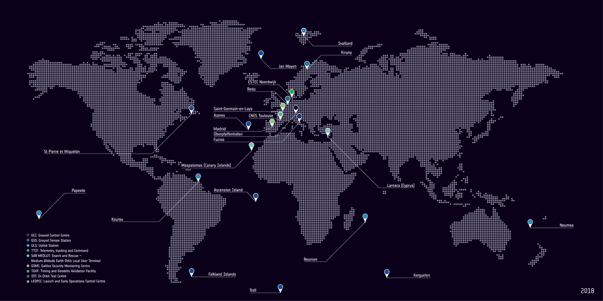
Galileo’s global ground segment. (Map: ESA)
This first work order for the “Galileo Control Segment Exploitation Phase” contracts GMV Aerospace and Defence as prime contractor to undertake all necessary activities to upgrade the Galileo Control Segment as part of Galileo’s Exploitation phase.
This work includes upgrading the system architecture to manage a constellation of up to 41 Galileo satellites, updating obsolescent elements in the current system, improving operability linked to the provision of services and the addition of a new, second TT&C station to be based in Kourou, French Guiana.
The integration, qualification, deployment and migration into operational service of the various segments of the upgraded Galileo Control Segment will be undertaken over the next three years.
The Galileo ground station near New Caledonia capital Nouméa incorporates a Galileo Sensor Station (foreground) that monitors the quality of navigation signals and an uplink station (background) to relay navigation corrections to the satellites for rebroadcast to users. An antenna 13 meters in diameter for controlling the satellites has also been built, ready to come online later this year. (Photo: ESA)
This process is to undertaken while maintaining coherence with the other segments of the overall Galileo system – such as the Galileo Mission Segment which oversees Galileo services, the external control centres that carry out initial satellite switch-ons and in-orbit testing and the satellite platform and payload manufacturers, OHB System AG in Germany and Surrey Satellite Technology Ltd in the UK.
ESA has issued this work order in its role overseeing Galileo’s deployment, the design and development of future upgrades and the technical development of infrastructure on behalf of the European Commission, Galileo’s owner.
Leica Geosystems has selected Getac’s fully rugged ZX70 Android tablet for the new Leica Zeno GG04 Plus Tablet package, designed for utilities, public services, transportation and construction.
The new partnership will allow Leica Geosystems to bring comprehensive geospatial data-collection capabilities to its customers in all terrains and weather conditions, according to a Getac news release.
Leica Geosystems selects Getac’s ZX70 tablet To power its new Zeno GG04 Plus Tablet solution. (PRNewsfoto/Getac)
The Zeno Mobile data collection app and Zeno GG04 plus smart antenna are designed to help customers capture highly accurate geospatial data quickly and effectively in the field.
By combining these products with Getac’s ZX70 Android tablet, Leica Geosystems has created a solution that offers measurement accuracy, connectivity and durability in a single, comprehensive package, Getac said.
Compact and powerful, the Getac ZX70 is comfortable to use with one hand, making it suitable for demanding field surveying work.
Its Android operating system supports Leica’s Zeno Mobile software, allowing for high-accuracy GNSS positions to be utilized and rich attribute data to be collected easily in the field.
Any authorized Android app can also be installed on the device, depending on the required workflow or back office systems used, bringing a high level of usability and familiarity out of the box, Getac said.
Additional key features include the 7-inch IPS display, which is easy to read in all environments, including direct sunlight. The LumiBond 2.0 touchscreen allows for full operation of the tablet in the rain and with gloves on, essential for outdoor surveying work.
The Getac ZX70’s integrated 4G modem can transmit large data files quickly and easily, even from remote locations.
The fast, stable and reliable data connection allows users to effectively utilize Hexagon Geosystems’ HxGN SmartNet correction service, enabling accurate GNSS measurement to within one centimeter.
The ZX70 offers durability, connectivity and usability, and has been designed to withstand shocks, drops, rain and vibration, the company added.
Antenova is shipping its ultra-small GNSS active antenna module for tiny positioning devices, the RADIONOVA M20047-1. The antenna module includes a low noise amplifier (LNA) and surface acoustic wave (SAW) filter for better positioning from difficult locations.
Antenova Ltd. is a manufacturer of antennas and RF antenna modules for connected devices and the internet of things.
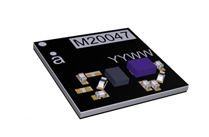
The RADIONOVA M20047-1 is designed for small consumer devices such as smartwatches. (Photo: Antenova)
The RADIONOVA M20047-1 is an active antenna module for GNSS applications in the 1559-1609 MHz satellite bands using GPS, GLONASS, Galileo or BeiDou.
The M20047-1 antenna module comprises an SMD antenna with built-in active components: an LNA filter and SAW to boost antenna performance — so designers will not need to add these — contained in a compact FR4 part with low power consumption, measuring 7.0 x 7.0 x 0.9 millimeters and weighing less than 2 grams.
The onboard LNA and SAW filter act to boost the signal to the GNSS processor in environments where there is a restricted view of the sky or where line-of-sight to the horizon is difficult, the company said.
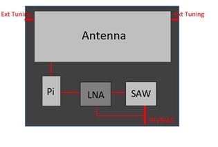
Architecture of the Antenova antenna. (Image: Antenova)
Antenova has also added an external matching feature to compensate for any de-tuning of the antenna caused by proximity to other components, such as a plastic case or a battery.
The clear-out area required by the antenna module is only 7.0 x 5.0 millimeters. This, with its tiny size, makes the M20047-1 suitable for small positioning devices where space on the PCB is tight, such as wearable devices, asset tracking devices, sports cameras and equipment and smartwatches.
The M20047-1 is an alternative to Antenova’s Sinica antenna (part no. SR4G008), which Antenova also recommends for accurate positioning.
The M20047-1 was first announced at the Consumer Electronics Show in Las Vegas in January.
Antenova’s antennas are specifically designed for easy integration. The datasheet and evaluation kit for the M20047-1 are available from www.antenova.com. Antenova also provides full engineering support, antenna testing, tuning and integration for its customers.
The tools connect directly to TomTom Maps APIs (Application Programming Interfaces) for location, tracking and mapping data services, accelerating product development, and reducing time-to-market and development costs for developers, the companies said.
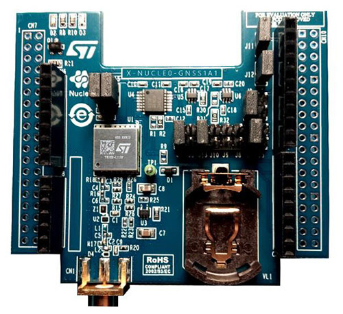
The X-NUCLEO-GNSS1A1 expansion board is based on the Teseo-LIV3F tiny GNSS module. (Photo: STMicroelectronics)
The development package consists of an STM32 Discovery host board for 2G/3G cellular-to-cloud connectivity, a GNSS expansion board based on ST’s Teseo satellite navigation technology, and a software Function Pack that connects an internet-of-things (IoT) node via a cellular network to a range of TomTom Maps APIs.
With this hardware and software package and a TomTom developer account, developers can quickly add location-based services to their IoT and smart city applications.
Among these services are the translation of GPS coordinates into a street address inside a map (Reverse Geocoding), retrieval of nearby point of interests, and the production of accurate navigation directions.
“We have combined TomTom’s industry-leading location-based and mapmaking technologies with ST’s unrivaled combination of silicon and system expertise to create a unique offering that provides easy access to TomTom’s Maps APIs to empower developers to create groundbreaking, location-aware applications faster and more efficiently,” said Anders Truelsen, managing director of TomTom’s Enterprise Business Unit.
“Supporting our efforts to facilitate location-based product development, our collaboration with TomTom has built on each company’s strengths to assemble a tailored package of hardware and software tools that is already fully integrated with TomTom cloud services, around the popular STM32 development ecosystem,” said Alessandro Cremonesi, group vice president at STMicroelectronics. “These tools enable native STM32-based location services to accelerate application development of Geo-IoT solutions for fleet management, item tracking, and many other services that depend on fast, accurate location detection.”
In addition to the STM32 family of Arm Cortex-M core microcontrollers, the development tools leverage ST’s market-proven multi-constellation Teseo positioning-receiver technology to perform all positioning operations including tracking, acquisition, navigation and data output.
Conducted online in July 2018, the GPS World State of the GNSS Industry survey compiled detailed answers to 30 key questions from 273 respondents, spread across six continents.
Prominent insights gained, and outlined in these pages: the PNT sector is booming, as opportunities outnumber obstacles; well-trained engineers are at a premium; and the Internet of Things is the newest market driver, perhaps the most powerful yet.
If you’ve taken a flight in Europe recently, then the chances are growing that you’ve been a pioneer EGNOS user. Satellites in orbit would have guided your airliner’s descent, rather than signals beamed from the ground. You wouldn’t have felt any difference — except for possibly a smoother ride.
Cockpit of a new EGNOS-equipped Airbus 350 XWB, on show during the inaugural EGNOS Day at Toulouse-Blagnac Airport on May 7, 2015. (Photo: ESA)
More than 180 European airports have now been certified to make use of the ESA-designed European Geostationary Navigation Overlay Service — EGNOS — for approaches to given runways. This includes approaches at major hubs such as Paris Charles de Gaulle, Frankfurt and Amsterdam Schiphol. Thanks to EGNOS, safe landings would still be possible even if an airport were shut down entirely.
Sharpening the precision of GPS satnav signals over most European territory, EGNOS was designed to make satnav reliable enough for safety-critical aviation employment, but has found a wide range of other uses, from agriculture to road, rail and maritime transport.
An EGNOS app is available from the Apple and Google Play stores, offering easy access to all EGNOS-related information, including the different EGNOS services, official documentation, historical and current performance data, support material and contact with the 24/7 EGNOS helpdesk.
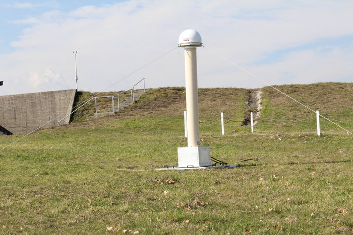
An EGNOS V3 Ranging and Integrity Monitoring Station (RAIMS) being tested at the Santiago de Compostella site in Spain, designed and manufactured by Thales Alenia Space in Italy. (Photo: ESA)
EGNOS is based on a network of monitoring stations across Europe that perform independent measurements of GPS signals, so that corrections can be calculated to boost satnav positioning performance. These results are passed to users immediately via a trio of geostationary satellites.
The service is allowed just a one in 10 million chance of error. If this tolerance is exceeded, EGNOS users are informed within six seconds. The result is that EGNOS-augmented signals meet the extremely high performance standards set out by the International Civil Aviation Authority, adapted for Europe by Eurocontrol, the European Organisation for the Safety of Air Navigation.
EGNOS operations are the responsibility of the European Global Navigation Satellite System Agency (GSA) of the European Commission and run by the ESSP, European Satellite Services Provider.
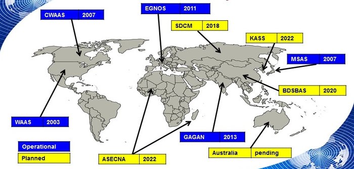
EGNOS is the European equivalent of the U.S. Wide Area Augmentation System (WAAS), which was the world’s first satellite-based augmentation system. The U.S. and European systems have been carefully designed to work together seamlessly.
Additional equivalent regional systems, fully interoperable with the existing ones are either in operation (Japan, India, Canada) or in definition or development (Russia, China, South Korea, West Africa and Australia).
Satellite-based augmentation systems worldwide. (Image: ESA)
Through the LPV-200 procedure, short for “localizer performance with vertical guidance 200 feet,” signals from space guide pilots through any weather down to within just 60 meters (200 feet) of the runway, at which point they make visual contact with the ground for a final go/no go landing decision.
EGNOS offers all-weather access to all certified runway approaches — each side of a runway requiring its own, separate, certification — without the need for expensive ground Instrument Landing System infrastructure. Satellite-based landing approaches can also be tailored to be smoother and more fuel-efficient.
Smaller airports unable to afford ground instrumentation draw the greatest benefit. Employing EGNOS means they get to operate in all weather conditions.
ESA retains the lead role in the future development of EGNOS, working with Thales Alenia Space and Airbus Defence and Space and their subcontractors to design, develop, deploy, and validate and test the new design elements.
While the current system is solely reliant on GPS, the next-generation EGNOS V3 will combine the use of GPS with Europe’s own Galileo satnav system to boost EGNOS accuracy and reliability still further. It is planned to enter service around 2025.
Trimble has launched a new model of its premium GNSS receiver, the Trimble R10 Model 2 GNSS System. Designed to help surveyors in a wide range of industries work more effectively and productively, the Model 2 enables reliable, fast and accurate collection of survey data in the field, the company said.
Enhancements in Model 2:
The latest and most advanced custom Trimble survey GNSS ASIC with 672 GNSS channels for unrivaled GNSS constellation tracking, including GPS, GLONASS, BeiDou, Galileo, QZSS and IRNSS as well as the full range of SBAS. The Trimble R10 Model 2 tracks and processes all of today’s available GNSS signals and is designed to support planned GNSS signals and systems that may be launched in the future.
Improved reliability against sources of interference and spoofed signals.
Improved power management to increase battery life and operating time in the field on average by 33 percent.
Increased internal memory (6 GB) to store more than 10 years of raw observations.
Support for Android and iOS platforms to allow organizations with Bring Your Own Device (BYOD) environments to benefit from a premium survey GNSS receiver by using the mobile devices their field crews already have in their pockets.
The new features build on the Trimble R10’s core technologies, which include the Trimble HD-GNSS processing engine that enables points to be quickly measured with confidence, Trimble SurePoint technology for precise positioning capture and full tilt compensation, Trimble xFill technology for centimeter-level positioning during GNSS outages, and support for Trimble CenterPoint RTX corrections for RTK level precision worldwide.
Advanced GNSS rover system
The Trimble R10 Model 2 supports the recently released Trimble TSC7 controller and Trimble Access 2018 field software. The Trimble R10, in combination with the TSC7’s large 7-inch screen and faster processing power plus Trimble Access 2018’s new user interface and graphics capabilities, gives surveyors a superior, comprehensive solution for collecting and computing data in the field.
“These improvements ensure the Trimble R10 remains one of the most current and relevant GNSS survey solutions on the market today,” said Olivier Casabianca, director of global marketing for Trimble Geospatial. “By providing a powerful rover system such as the R10 Model 2, TSC7 controller and Access 2018 field software, Trimble continues its legacy of unmatched GNSS expertise and knowledge to advance the capabilities of surveyors around the world.”
Esri is updating the ArcGIS Living Atlas of the World, a vast collection of geographic information from around the globe. The updates include new data and capabilities for users to gain insight for helping in decision making, as well as a more complete and dynamic picture of the world.
The new features were introduced at this year’s Esri User Conference, held July 9–13 in San Diego, California.
The new Earth Systems Monitor app, powered by Living Atlas data, showing Sea Surface Temperature. (Image: Esri)
Earth Systems Monitor. This new app (currently in beta) is powered by Living Atlas data. It allows users to see — on a 2D map or a 3D globe — historical, forecasting and real-time data for depicting land, the oceans and even the human footprint.
Users can see where events or phenomena such as marine temperature shifts are occurring at any time on the planet, or even model global population growth and its effects, the company said.
The configurable app will be released later this year. The app can be used with Living Atlas data layers or with other layers from an organization’s own data or ArcGIS Online.
Wayback Imagery. This digital archive of the World Imagery basemap enables users to access more than 80 different versions of world imagery captured over the past five years.
Each record in the archive represents a version of world imagery as it existed on the date it was published. Users can move back and forth in time and choose the imagery they want to use.
OpenStreetMap Vector Basemap. Moving to a local scale, OpenStreetMap (OSM) is an open, collaborative project to create a free editable map of the world, built by a community of mappers who contribute and maintain data about roads, trails, buildings, restaurants and more.
Until now, OSM was only available as a raster basemap in ArcGIS Online. The new vector basemap, introduced in beta, will be available for free to all ArcGIS users and developers.
“The Living Atlas shows how our community of users continues to contribute to the innovations that power our technology,” said Jack Dangermond, Esri founder and president. “The beauty of these new features is that they transform the data that users are supplying into valuable online services like Earth Systems Monitor.”
Living Atlas can be used to create indexes displaying properties such as vegetation health or soil moisture and quantifying the changes over time, enabling better understanding of the environment.
Earth Systems Monitor, OSM Vector Basemap and Wayback Imagery are all examples of how online GIS technology is transforming traditional mapping organizations into web service providers, Esri said. These innovations are just the latest steps in creating a living digital twin of the systems and processes that help run organizations, cities and even nations.
By fostering the adoption of apps, web maps, and collaborative efforts, Living Atlas is supporting end users who face increasing geospatial data demands, enabling them to be self-sufficient with the application of location intelligence across their organizations.
Wayback Imagery is currently accessible, while both OSM Vector Basemap and Earth Systems Monitor will be available soon in ArcGIS Online.