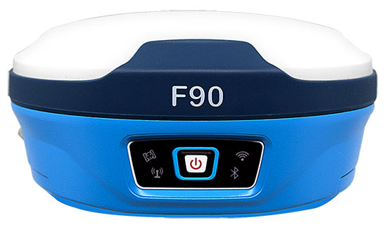
Geneq Inc. has released the F90, a multi-constellation GNSS receiver with a high level of technology integration. The new product is designed to fulfill surveyors’ demands for performance, flexibility and cost-effectiveness.
The F90 tracks multiple constellations (GPS, GLONASS, Galileo and Beidou) and can maximize the acquisition and tracking process with all-in-view GNSS satellite frequencies, the company said.
Providing maximum performance for accuracy and real-time measurements, the F90 also supports real-time kinematic correction services, including the RTX service that can achieve centimeter accuracy without a base station.
The F90’s advanced technology ensures a high performance even in harsh environment such as under heavy canopy, Geneq said.
The F90 has an excellent combination of GNSS, 4G, Bluetooth and Wi-Fi antenna. With highly integrated Bluetooth, Wi-Fi and 4G network modules, and without affecting accuracy and efficiency, the innovative F90 GNSS receiver is light and small. Even with its magnesium-alloy casing, F90 weighs only 1 kilogram and measures 140 x 157 x 76 millimeters.
With its integrated highly sensitive E-bubble and new tilt survey algorithm, the F90 becomes a calibration-free GNSS receiver, Geneq said. It is immune to magnetic disturbance and free from the limitation of tilt angles so that it can be used to measure inaccessible points.
Equipped with an internal radio, enabling frequency band change from 410 to 470 MHz, the F90 can be used with different radio communication protocols. Another important feature is its integrated second-generation web user interfae control, which is fully compatible with all devices and all browsers.
The user will benefit the F90’s two smart hot swappable Lithium batteries (the same battery used with Geneq’s SXPad 1000P data collector), allowing uninterrupted field work for up to 10 hours.
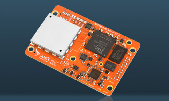
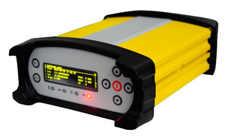
The Piksi Multi GNSS receiver. (Photo: Swift Navigation)
Swift Navigation has upgraded the firmware to its flagship product — the Piksi Multi GNSS receiver. This marks the sixth major release to Piksi Multi since it was launched in February 2017.
The upgrade is available free of charge to Swift customers.
The firmware release also enhances Duro, the ruggedized version of the Piksi Multi receiver housed in a military-grade, weatherproof enclosure for long-term outdoor deployments.
Swift Navigation is a San Francisco-based tech firm building centimeter-accurate GNSS technology and a cloud-based corrections service to power a world of autonomous vehicles, the company said.
The Duro enclosure. (Photo: Swift Navigation)
Firmware Release 2.0 for Piksi Multi and Duro supports two additional major satellite constellations — the Chinese constellation (BeiDou B1/B2) which, once completed, will contain 37 satellites and the European Union-based constellation (Galileo E1/E5b), which will eventually consist of 30 satellites.
Adding to the existing GPS, GLONASS and SBAS constellations already supported by Swift’s GNSS receivers means that users will have more access and visibility from satellite systems across the globe.
Piksi Multi’s performance will further improve over time as the total of 136 satellites planned for these major constellations are fully deployed.
The addition of BeiDou and Galileo constellations creates more robust positioning performance in a variety of challenging skyview environments and puts Piksi Multi on par with leading industry receivers costing up to ten times a much.
With this 2.0 release, Piksi Multi is feature-complete, and Swift’s engineering team has delivered on planned product features on the Piksi Multi Product Summary.
MSM Messages 4-7. The new firmware adds support for RTCM 3.2 Multi Signal Messages (MSM). Though Swift devices already support RTCM 3.1, the addition of MSM allows for another flavor of differential corrections supported by BeiDou and Galileo, while also supporting both GPS and GLONASS with MSM new messages. MSM also allows for interoperability with other existing third-party GNSS receivers for all modern signals and constellations.
Fix Improvements. Firmware 2.0 provides Piksi Multi and Duro improvements on fixing in long base lines in poor atmospheric conditions, making the devices more resilient to Ionospheric effects during periods of high Ionospheric activity.
Higher Baud Rate Support for UART. New baud rates were added including 460800 and 921600.
Acquisition Improvements. Enhancements made allow Piksi Multi and Duro to power on to a usable signal more quickly and acquire satellites in start-up mode faster, by several seconds.
“The growing Swift engineering team has been hard at work developing Piksi Multi to its full potential,” said Samir Kapoor, executive vice president of engineering and product at Swift Navigation. “With support for all modern satellite constellations and multiple performance improvements, Piksi Multi offers unmatched affordability, priced at ten times the savings yet on par with other leading GNSS receivers.”
“Swift’s vision of making GNSS devices that are centimeter-accurate, with fast RTK convergence times and robust positioning performance all at highly-competitive prices has come to fruition,” Kapoor said. “With Piksi Multi feature complete, we look forward to adding to our line of products with additional offerings later this year.”
A link to the live event will be sent to you two hours before the event. Your personalized event URL will be automatically generated by the ON24 system. To ensure receipt of the email, please whitelist this email address by adding it to your contacts: [email protected].
This presentation will begin on at 1 p.m. EDT / 10 a.m. PST on Thursday, September 6, 2018.
Audience members may arrive 15 minutes prior to live time. If you have any questions, please contact event producer Danielle Presta at [email protected].
Rohde & Schwarz has expanded the capabilities of its R&S CMW500 wideband radio communication tester and R&S SMBV100A GNSS simulator to support Global Certification Forum (GCF) protocol conformance tests for C-V2X device certification.
Utilizing the Qualcomm 9150 C-V2X chipset solution from Qualcomm Technologies Inc., a subsidiary of Qualcomm Incorporated, the R&S CMW500 acting as LTE network simulator now allows automakers to test C-V2X direct communications (PC5) according to GCF Work Item 281.
3GPP Release 14 specifies the direct communications specifications for C-V2X PC5, which enables vehicle-to-vehicle (V2V), vehicle-to-pedestrian (V2P) and vehicle-to-infrastructure (V2I) safety applications, and does so without a mobile cellular subscription or network assistance and operates in ITS bands 46D (5.8 GHz) and 47 (5.9 GHz).
The new R&S CMW-KK550 test package includes the 3GPP Protocol Conformance tests from LTE-V2V GCF Work Item 281 and LTE-V2X GCF Work Item 282. As recently announced, the R&S CMW-KU514 C-V2X software package on the R&S CMW500 is used to verify data transmission and reception over the PC5 interface in ideal, faded and congested channel conditions. Together, both packages enable Rohde & Schwarz to support C-V2X device testing through all protocol layers.
C-V2X device testing is a significant step towards achieving the goal of having fully connected and autonomous vehicles to improve public safety and increase traffic efficiency.
C-V2X, including direct communications for safety applications, nicely and synergistically complements network-based communications that deliver telematics services and various use cases for connected infotainment and over-the-air software updates.
“C-V2X PC5 radio technology has quickly advanced to a pre-commercial stage, and Rohde & Schwarz is pleased to be the first test equipment vendor to offer a comprehensive C-V2X test suite,” said Anton Messmer, vice president of mobile radio testers at Rohde & Schwarz. “The automobile industry can now verify functionality and performance of C-V2X devices, as well as start device testing as per 3GPP protocol conformance tests.”
“This expanded capability complements our support for European eCall and shows our long-standing support for automotive applications,” Messmer said. “Rohde & Schwarz is committed to providing industry-leading test platforms for C-V2X device performance testing and GCF device certification.”
A number of geospatial companies played a key role in the government’s response to the Kilauea Volcano eruption. The volcano on the Big Island of Hawaii began erupting May 3, and while quiet for more than a week, it could resume erupting at any time.
Mapping the flow. As a resident of Hawaii, Brennan O’Neill, Hawaiian branch manager of Frontier Precision, was in a unique position to offer support. Frontier Precision provided free access to technology and expertise to assist in mapping the lava flow.
“I had to help out,” O’Neill said. “It was tearing at my soul. For a geologist, it’s even more powerful than that. The lava flow is like a living mass that has a mind of its own, creeping, glowing — an upside-down conveyor belt surging forward and burning everything in its path.”
Through Frontier Precision, O’Neill offered high-tech mapping equipment, his own expertise, and the help of Nathan Stephenson, an applied geospatial engineer working in the company’s Denver office.
“We used a combination of Trimble R10s and Trimble R8s to gather accurate data points on the ground,” Stephenson said.
This thermal map shows the fissure system and lava flows as of 6 a.m. on Saturday, Aug. 11. The thermal map was constructed by stitching many overlapping oblique thermal images collected by a handheld thermal camera during a helicopter overflight of the flow field. The base is a copyrighted color satellite image (used with permission) provided by Digital Globe. (Map: USGS)
The mapping team flew UAS drones over the flow to gather visual imagery data, matched it to the ground reference points, stitched the photos together and draped it over county maps. The process was repeated as often as needed — daily, and sometimes even hourly — to show the speed and direction of the flow.
Stephenson isn’t new to mapping lava flows. As a graduate student at the University of Hawaii – Hilo, he worked on collecting data on the Pahoa eruption in 2014, and he’s seen advances in technology in just a few years.
“One thing we have now that we didn’t have in 2014 was a thermal radiometric camera that helps us map more accurately at night and enables us to capture large heat signatures.”
The collected data helps Hawaii Civil Defense and other agencies keep the public informed and safe, and in the long term it also contributes to the store of scientific knowledge about eruptions and lava flow behavior.
Lidar image of the Hawaii dataset showing the Kilauea Calderand the Halena’uma’u Crater and within it. (Image: Quantum Spatial)
Airborne lidar insights. Another technology that aids in volcano response is lidar. High-resolution lidar surveys help first responders, scientists and government agencies monitor Kilauea conditions and predict future lava flows.
Independent geospatial data firm Quantum Spatial Inc. (QSI) has conducted high-resolution lidar surveys of areas surrounding the Kilauea volcano eruption in Hawaii.
The emergency response effort was part of the U.S. Geological Survey’s (USGS) Rapid Response Imagery Products (RRIP) in support of the Kilauea’s 2018 East Rift Zone – Remote Sensing Acquisition Requirement.
The USGS Hawaiian Volcano Observatory (HVO), along with emergency responders, government agencies and academics, will use the data to better understand the conditions and characteristics of the volcano, and help planners model potential lava flows, which may better predict and respond to future flows and enhance safety of residents.
The QSI team, which included GEO1 and Windward Aviation, deployed within days to acquire high-resolution lidar at point densities averaging from 40 to 80 ppsm, with up to 150 ppsm in select areas and 100-mp digital imagery using a Riegl dual VUX-1 LR sensor pod equipped with ABGPS/IMU mounted on a Hughes 500D helicopter.
The project required 11 missions over the course of six days, operating at times as low as 500 feet above the ground and above active flows and nearby erupting calderas. With a need for a quick turn around, QSI deployed an analyst with the flight crew to post process each mission within hours of collection.
The data was uploaded to the Geospatial Repository and Data Management System (GRiD) interface, developed by the U.S. Army Corps of Engineers (USACE), where additional data products have been developed and provided to the response team that includes FEMA, Hawaii’s Emergency Operations Center (EOC) and the Hawaii County Civil Defense.
After data collection, QSI measured topographic shifts during the processing by comparing new data with a 2011 lidar collection from the same area. Survey specialists and USGS experts confirmed within hours of processing QSI’s lidar data that areas within the site had shifted up to 1.5 meters east, 2 meters to the north and 1 meter in elevation.
USGS scientists will continue to examine the new topographic data to better understand the nature of these shifts, and integrate it into lava flow models for more accurate predictive modeling.
The eruption in action. Using small unmanned aerial systems (sUAS) together with air-quality sensors, advanced imaging tools and Esri’s spatial analytics and mapping, a team from the Center for Robot-Assisted Search and Rescue (CRASAR) provided real-time aerial views of the eruption.
The five volunteers armed with drones, advanced sensor systems and GIS technologies joined the response effort May 14-19 at Kilauea Volcano Lower East Rift Zone to assist in tracking and predicting the ongoing volcanic eruption. The team supplemented the University of Hawaii Hilo’s (UHH) sUAS capabilities, allowing UHH sUAS operators to focus on geographical and volcanology.
The CRASAR team identified a new fissure not visible from the ground, projected the lava flow rate during the night when manned helicopters were not allowed to fly, and provided ongoing data collection from new thermal sensors technology.
During the six-day Leilani deployment, the CRASAR team flew 44 sUAS flights, including 16 at night, using DJI 200, 210, Inspire, and Mavic Pro drones. Esri’s Drone2Map for ArcGIS together with Hangar’s Enterprise Platform for 360-degree imaging enabled rapid 360-imaging for situational awareness.
DJI’s new XT2 thermal sensor provided unprecedented drone-based air-quality monitoring. Video and data were shared with local first responders using FirstNet, the first high-speed, nationwide wireless broadband network dedicated to public safety.
The CRASAR response marks the first known use of sUAS for emergency response to a volcanic eruption and first known use of sUAS for sampling air quality.
The GIS mapping and imaging technologies responders used on the scene at Kilauea Volcano Lower East Rift Zone are available here.
Remote GeoSystems Inc., a global provider of geospatial video recorder hardware and GIS integration software and solutions, has become an official Silver Partner in the Esri Partner Network after successfully building its business as an Emerging Business Partner in the Esri Startup Program.
Esri offers a Startup Program enabling the most promising emerging businesses to incorporate these innovations into their services and solutions.
Now in its third year, the Esri Startup Program provides the ArcGIS software, online services, support, community involvement and training to kick-start product development or enrich existing solutions.
Remote GeoSystems was one of the first early-stage startups accepted into the program.
“As a small technology company bootstrapping the development and innovative product sales efforts, access to Esri’s flagship ArcGIS platform and team support was invaluable,” said Jeff Dahlke, managing director of Remote GeoSystems.
The LineVision Desktop. (Image: Remote Geosystems)
In its three years in the program, Remote GeoSystems was able to successfully develop and go to market with an array of geospatial video solutions. The company’s LineVision Esri ArcMap Add-in and stand-alone LineVision Desktop with Esri Mapping commercial software tools provide georeferenced video playback, analysis, collaboration and reporting using the Esri ArcGIS platform.
In addition, the new Video GeoTagger and Video GeoEditor (coming soon) products, also built with Esri mapping technology, will be available for use on the ArcGIS Marketplace.
These professional geospatial video and integrated GIS Full Motion Video (FMV) software tools are suitable for airborne, drone and mobile mapping surveys, critical infrastructure inspection and public safety applications.
“The Remote Geo team is building some very feature-rich and capable Esri-based solutions and Add-ins while also bringing a valuable mix of GIS, GPS, deep location-based video expertise and multi-industry experience,” said Francis Kelly, Esri Global Partner Programs manager. “We are excited to work with Remote Geo as their business matures and they continue to contribute to the Esri user community as part of the Esri Partner Network.”
“As a company that was once a startup, we understand the early years for any business are hard,” said Katie Decker, Esri Startup Team community manager. “We are impressed with how the Remote Geo team executed on the opportunities provided by the program, bringing the value of geospatial video to a broader audience using the Esri platform. Their experience is what we envisioned when we implemented the program and we look forward to continuing to work with them.”
Remote GeoSystems LineVision Esri-based solutions key features often include:
Play videos from single and multi-camera video data collection platforms
“Click-on-Map” video navigation
Set a custom geo-fence around the moving position marker
Load shapefiles, imagery and ArcGIS Online datasets
Save geotagged video and photo data as geoProjects for simple project reporting, archive and search
Support for DJI Drone Video data.
All Remote GeoSystems Esri-based solutions are and/or will soon be available in the ArcGIS Marketplace.
The startup PlanetWatchers has developed Foresights, a risk management and geospatial analytics platform designed specifically to help clients manage forestry assets quickly, effectively and accurately.
Foresights identifies areas of new or potential risk, and delivers operations tracking and forest damage management services. The company plans to add satellite-driven analytics, inventory data and forest productivity services to the platform. before the end of the year.
The Foresights platform covers larger geographic areas and delivers results faster and more accurately than traditional project-based companies, traditional inventory methods and off-the-shelf processing tools, the company said.
PlanetWatchers combines multi-source satellite imagery data, topography maps, soil maps, meteorological data and near real-time ground input from operational teams to deliver optimized insights. The tool is capable of detecting disturbances as small as 0.1 ha (0.25 ac) related to pest, disease and drought damage.
Foresights will help forest managers “easily access crucial business intelligence and detailed insights and analytics on a regular basis so they can make proactive and informed decisions and take immediate remedial action,” said Ariel Smoliar, PlanetWatchers’ CEO and co-founder. “Without these higher levels of data and improved frequency of information, they could see negative impacts on their forestry management decisions, their supply chains and, ultimately, their profits.”
Reports identifying locations that require immediate mitigation can be viewed in existing GIS systems and are geolocated for forestry field teams, including offline capabilities for teams operating in remote areas without cellular reception.
“Foresights also fills a data gap known as the ‘Last Mile of Analytics’,” Smoliar said. “When we deliver satellite images to our clients, they shouldn’t have to then analyze and extract information. We remove this pain point for them by providing deep analysis of optical and radar satellite images, and compiling actionable insights and reports, including detailed maps of locations of interest. Our clients are shown not only the location of the disturbance, but also the issue and its cause, granting them vital intelligence they can act on with very little lag time. Foresters will no longer need to process or analyze imagery: this is the game-changing value of the Last Mile of Analytics.”
The Forest Operations service provides foresters with insights to track progress of various forest harvest operations such as thinning and clearcutting. This information assists operations managers in optimizing their wood supply chain and efficiently and effectively managing resources.
The Forest Disturbance service delivers location-specific reports to forest owners and managers detailing areas with identifiable disturbances that could degrade the quality, yield, and profitability of forests. Some disturbances that Foresights can identify to help commercial foresters respond proactively include growth and uniformity issues over time, illegal logging, insect infestations and disease, competitive vegetation, storm damage, drought, wildfires and more.
Deployed service members may have to ditch their fitness trackers in response to a new memo from Deputy Defense Secretary Patrick M. Shanahan prohibiting the use of GPS functions in deployed locations.
This includes physical fitness aids, applications in phones that track locations, and other devices and apps that pinpoint and track the location of individuals.
Pentagon spokesman Army Col. Robert Manning III announces the policy on geolocation devices at the Pentagon, Aug. 6, 2018. (Photo: DoD/Jim Garamone)
“Effective immediately, Defense Department personnel are prohibited from using geolocation features and functionality on government and nongovernment-issued devices, applications and services while in locations designated as operational areas,” Pentagon spokesman Army Col. Robert Manning III told Pentagon reporters on Aug. 6.
Deployed personnel are in “operational areas,” and commanders will make a determination on other areas where this policy may apply.
The market for these devices has exploded over the past few years, with many service members incorporating them into their workout routines. They use the devices and applications to track their pace, running routes, calories burned and more. These devices then store the information and upload it to central servers where it can be shared with third parties. That information can present enemies with information on military operations.
Using GPS Devices Pose Risk
Photo: Fitbit
“The rapidly evolving market of devices, applications and services with geolocation capabilities presents a significant risk to the Department of Defense personnel on and off duty, and to our military operations globally,” Manning said.
The GPS capabilities can expose personal information, locations, routines and numbers of DoD personnel. Their use in overseas locations “potentially create unintended security consequences and increased risk to the joint force and mission,” Manning said.
Personal phones and other portable devices also contain apps that rely on GPS technology, and they will be affected. Commanders will be responsible for implementing the policy, and they will be allowed to make exceptions only after conducting a thorough risk assessment.
Security is at the heart of this guidance. DoD seeking a balanced way that allows for legitimate official and personal uses of geolocation technology that does not impact security.
Manning said the department will continue to study the risk associated with these devices and change the policy as needed.
A link to the live event will be sent to you two hours before the event. Your personalized event URL will be automatically generated by the ON24 system. To ensure receipt of the email, please whitelist this email address by adding it to your contacts: [email protected].
This presentation will begin on at 1 p.m. EDT / 10 a.m. PST on Thursday, August 16, 2018.
Audience members may arrive 15 minutes prior to live time. If you have any questions, please contact event producer Danielle Pest at [email protected].
Geneq Inc. has introduced the Net20 Pro, a robust system designed for Continuously Operating Reference Station networks.
The Net20 Pro’s efficiency and flexibility will provide high-quality data for users interested in the proximity and reliability of a reference station while eliminating real-time kinematic (RTK) corrections service charges, the company said.
The Net20 Pro uses multi-frequency, 555-channel technologies in a rugged casing to deliver accurate and effective positioning data even in a harsh environment.
The receiver can be configured for correction data reception in client mode to calculate a fixed RTK position and to monitor the antenna position while continuing to work as a GNSS reference server.
With its NTRIP Caster software, the Net20 Pro provides superior connectivity with an unlimited number of mount points, Geneq said. Users can have permanent transmission of RTK corrections with a simple local internet connection from a LAN working network.
Equipped with an internal memory of 32 GB with an additional 32 GB external memory, the Net20 Pro provides enough storage space for permanent recording even for a 100-Hz high data sampling rate.
The Net20 Pro comes with an ergonomic and easy-to-manage web user interface that features software upgrade, status and settings management, as well as data downloading via smartphone, tablet or other internet-enabled electronic devices.
Fairweather crew lower a launch into Puget Sound, Washington, for Hydrographic Systems Readiness Review testing. (Photo: NOAA)
U.S. researchers have completed the first high-resolution, comprehensive mapping of one of the fastest moving underwater tectonic faults in the world, located in southeastern Alaska.
The mapping information will help communities in coastal Alaska and Canada better understand and prepare for the risks from earthquakes and tsunamis that can occur when faults suddenly move.
Since 2015, scientists have been gathering data on the Queen Charlotte-Fairweather fault system, a 746-mile long strike-slip fault line that extends from offshore of Vancouver Island, Canada, to the Fairweather Range of southeast Alaska.
Team members are from the National Oceanic and Atmospheric Administration (NOAA), the U.S. Geological Survey (USGS) and their partners.
The most recent survey came from NOAA ship Fairweather, with USGS scientists aboard from April through July, when it collected multi-beam bathymetric data in an area along the U.S. and Canadian international border in water depths ranging from 500 to more than 7,000 feet deep.
Researchers aboard NOAA Ship Fairweather collected multibeam bathymetric data in an area along the U.S. and Canadian international border in water depths ranging from 500 to more than 7,000 feet deep from April through July. (Image: USGS)
“Providing scientific information to help protect vulnerable communities is one of our most important missions,” said W. Russell Callender, assistant NOAA administrator for the National Ocean Service. “Working with USGS and our state and academic partners, allows us to speed the development of information that can help communities better anticipate and prepare for risks from tsunamis and earthquakes.
“This project has been a great collaboration on an important scientific issue with significant implications for public safety,” said David Applegate, USGS associate director for natural hazards. “We will apply what we learn from this mapping mission to hazard assessments for Alaska’s coastal communities. Partnering with NOAA reflects the importance of addressing earthquake and associated tsunami hazards to both our missions, and it enables the USGS to bring our geologic expertise to bear on offshore fault structures that have significant onshore implications.”
Fault line activity poses a hazard to the growing populations of Juneau, Sitka and other communities throughout southeastern Alaska, as well as more than a million annual tourists and the seafloor infrastructure critical for Alaska’s communications and offshore energy industries.
With a slip rate of more than 2 inches per year, this fault may be one of the fastest-moving strike-slip faults in the world. (For comparison, the San Andreas fault in central California slips about an inch to an inch-and-a-half each year.)
Movement between the tectonic plates at the fault line has generated six earthquakes of magnitude 7 or greater within the last century. One of those earthquakes, a magnitude 7.8 earthquake near Lituya Bay, Alaska, in 1958 triggered a landslide that sent water 1,720 feet up an adjacent mountainside, one of the highest recorded run-ups of a tsunami — a rapidly rising turbulent surge of water often choked with debris.
A NOAA survey ship uses its multibeam echo sounder to conduct hydrographic surveys. (Image: NOAA)
A series of large-magnitude earthquakes and associated aftershocks in 2012 and 2013 spurred research cruises in 2015, in the first systematic effort to study the offshore Queen Charlotte-Fairweather fault system in U.S. territory in more than three decades.
A similar effort led by the Geological Survey of Canada has been underway along the portion of the fault located in Canadian territory.
The 2018 Fairweather survey built on five previous USGS-led marine geophysical and geological surveys between 2015 and 2017 in southeastern Alaska aboard a number of research vessels, as well as two cruises led by researchers from the Geological Survey of Canada, Sitka Sound Science Center and USGS.
During these surveys, researchers used an array of instruments to collect data on seafloor depth and texture, to profile sedimentary layers beneath the seafloor, and to derive sediment ages.
NOAA Ship Fairweather underway in Alaska. (Photo: NOAA)
NOAA nautical charts will be updated with the Queen Charlotte Fault data within a year once the data goes through a standard quality control process — although the fault area is too deep for any obstructions to pose a threat to marine traffic.
This research is part of a larger two-year effort between the NOAA Integrated Coastal and Ocean Mapping Program and USGS to map large portions of the Cascadia continental margin in federal waters offshore of Alaska, California, Oregon and Washington.
Under the grant, TCarta will enhance and automate multiple techniques for deriving seafloor depth measurements from optical satellite imagery.
The Project Trident research seeks to transform existing satellite-derived bathymetry (SDB) techniques by using machine learning and computer vision technology to enable accurate depth retrieval in variable water conditions.
If successful, these enhanced bathymetric techniques will improve operations related to oil and gas exploration and production, coastal infrastructure engineering, environmental monitoring and geointelligence activities, the company said.
“Our goal with Project Trident is to expand the geographic scope of SDB in shallow coastal areas,” said Kyle Goodrich, TCarta president. “SDB technology currently derives water depths only in calm, clear waters, which limits its applicability.”
Beta testers sought
TCarta is seeking beta testers for participation in Project Trident research. If you are interested, contact Project Trident Principal Investigator Kyle Goodrich at [email protected] or complete the online Project Trident survey.
TCarta won the grant for Project Trident in partnership with jOmegak of San Carlos, California, and DigitalGlobe of Westminster, Colorado, in Phase 1 of the NSF Small Business Innovation Research program.
The one-year research project will be carried out at the TCarta facility in Denver.
In 2014, TCarta successfully commercialized a proprietary technique for digitally extracting water depth measurements down to 20 meters from high-resolution DigitalGlobe WorldView satellite imagery.
The SDB products became popular with organizations operating in shallow coastal waters because the technology is more cost-effective and timely than traditional airborne and ship-borne bathymetric methods — with no adverse effects on the environment, the company added.
“In the current SDB process, we use manual stereo photogrammetry methods to measure seafloor ground control points in digital satellite imagery, but this is extremely time consuming,” said Goodrich. “We are developing an automated photogrammetric process to extract a greater number of ground truth points from high-resolution WorldView imagery.”
Project Trident aims to integrate wave kinematics, a technique patented by jOmegak to calculate water depths in shallow waters by analyzing the patterns and speed of waves detected in satellite imagery. Wave kinematics has been applied successfully using Sentinel-2 and WorldView satellite imagery.
“Thanks to the NSF grant, we are taking a giant leap forward on TCarta satellite-derived bathymetry methodologies and aim to exponentially accelerate them with the latest in machine learning and computer vision technologies,” said Goodrich.