Partnership with Fujitsu will help city track bicycles, e-scooters and ridesharing companies
The mobility department of Munich, Germany, has selected Hexagon Geospatial to implement a smart monitoring system to better manage and understand the impacts of shared mobility services in the city.
Hexagon will partner with Fujitsu to provide Munich a software-as-a-service (SaaS) solution for tracking, visualizing and analyzing internet of things (IoT) data from a variety of mobility providers. The solution will monitor shared vehicles, such as e-scooters, bikes and cars, and will be the first of its kind in Germany.
The solution will also feature a dynamic digital twin of the city, allowing users to fuse the real and digital worlds and receive constant updates. Along with Hexagon’s M.App Enterprise software, Fujitsu will provide the necessary infrastructure for the project, which is designed to evolve constantly according to officials’ needs.
Hexagon was selected from among 14 competitors based on the technical completeness and capabilities of its offering and established expertise in the transportation domain. With this smart monitoring system in place, the city can continually monitor and guide future mobility concepts based on data.
“Shared mobility is a big issue around the world, and the city of Munich is on the leading edge of leveraging technology to manage these services,” said Maximillian Weber, senior vice president, EMEA, Hexagon’s Safety & Infrastructure and Geospatial divisions. “We are excited to deliver a system that will help officials better identify and understand transportation patterns with the goal of improving future city mobility.”
Tracking eScooters in Munich with Hexagon’s M.App Enterprise. (Image: Hexagon Geospatial)
Ground antenna at Schriever Air Force Base, home of the 50th Space Wing. (Photo: Raytheon)
The United States Space Force’s Space and Missile Systems Center (SMC) awarded a $228 million contract to Raytheon Intelligence and Space for the GPS Next-Generation Operational Control System (OCX) Follow-On (OCX 3F). The contract award was made on April 30.
OCX 3F upgrades the OCX Blocks 1 and 2 system to use the enhanced capabilities of the new GPS IIIF space vehicles being developed by Lockheed Martin. The OCX 3F program — in combination with the GPS IIIF space vehicle program — ensures positioning, navigation and timing (PNT) will continue to be available for future generations, said the Los Angeles Air Force Base in a press release.
The OCX 3F program is part of the GPS Enterprise Modernization effort. GPS OCX Blocks 1 and 2, planned for delivery in 2022, will represent a major evolution in capabilities for the GPS enterprise. In addition to supporting the latest U.S. Department of Defense standards and practices for cybersecurity, OCX 3F also supports advanced features over the legacy GPS ground segment. The new features include:
an enhanced and expanded network of monitoring stations for improved cybersecurity and improved anti-jam capability
enhanced operational capability to control the modernized military signals
support of GPS III boosted Earth coverage military code (M-code)
monitoring of new Galileo-compatible and safety-of-life signals.
“OCX is an adaptive architecture designed to evolve to combat emerging threats. OCX 3F is a great example of modifying the OCX Blocks 1 and 2 software baseline to launch and incorporate the GPS IIIF enhanced satellite capabilities,” said Barbara Baker, SMC Production Corps Command and Control Systems Division’s senior materiel leader. “I look forward to continuing our relationship with Raytheon in delivering the United States Space Force GPS capabilities.” Raytheon Intelligence and Space will perform the work in Aurora, Colorado, and delivery is expected in July 2025.
“The OCX 3F program office is looking forward to working with Raytheon on this new GPS ground control program. We are ready to take on any challenges and to work full bore to deliver the critical regional high-powered signals and GPS IIIF launch and control capabilities in support of joint warfighters,” said Lt. Col. Grant Spear, SMC OCX 3F materiel leader.
Racelogic, the company behind LabSat, has been named as one of the “10 Ones to Watch” in the 22nd annual The Sunday Times BDO Profit Track 100, which ranks Britain’s top private companies.
The Profit Track 10 Ones to Watch list represents a cross-section of companies that have achieved or predict good profit growth. In addition to profit performance, inclusion is also based on factors such as resilience in the face of the pandemic and strength of the business model.
Graham Mackie, CEO of Racelogic, was delighted to see the hard work of his team recognized by industry experts. “In a challenging year, we are proud of our performance and the way in which every member of the team at RACELOGIC has adapted to new ways of working and serving our customers,” he said.
The Buckingham-based business sells to more than 100 countries and generated 88% of its sales overseas last year. “We have great products that service a global market that provided some resilience to the impact of the pandemic,” Mackie said. “We are continuing to develop cutting-edge technology, which is enabling us to diversify into new sectors including the film and gaming industries.”
The sales growth and addition of new products has resulted in Racelogic expanding its workforce at a time when many are having to reduce staff numbers, Mackie said. “We are currently recruiting for a range of engineering and administrative positions, all of which can be found on our website. It is an exciting time to join Racelogic, and perhaps even more so now that we are officially ‘one to watch’.”
The 10 Profit Track Ones to Watch finalists will be judged by Stuart Lisle, senior tax partner at BDO, and Hamish Stevenson, founder of Fast Track. The winner will be announced at the Profit Track 100 virtual awards event in June.
The High-BIAS2 project advances cold-atom quantum gyroscope
The High-BIAS2 (high-bandwidth inertial atom source) project today announced new milestones that move the industry closer to safer skies with more precise inflight navigation systems. The project has advanced its development of a cold atom-based quantum positioning system (QPS), which enables vehicle navigation without a GPS or GNSS signal.
Reducing the reliance on GPS and GNSS technologies is critical for scenarios where signals from these systems are not available, such as underwater or in space, or when they suffer disruptions due to technical issues, cyberattacks and atmospheric or reflection effects.
High-BIAS2 is designed to demonstrate the rapid commercialization of quantum technologies for real-world applications.
“Inertial navigation systems enhanced by ColdQuanta’s Cold Atom Quantum Technology hold the promise of navigation in the absence of GPS and GNSS.”
Inflight Trials. The project will culminate with inflight trials via BAE Systems’ test aircraft to validate the gyroscope’s use for aerospace applications. The airborne technology demonstrator will consist of a quantum gyroscope sensor and control system, reference gyroscope and commercial navigator system.
“Gyro technology is a key aspect of navigation for airborne platforms. Improving performance whilst still being compatible with the aerospace environment is something that BAE Systems sees as important in aiding navigation when GNSS signals aren’t available,” said Julia Sutcliffe, air chief technologist, BAE Systems. “We can see exciting applications across our defense, security and commercial businesses including land, sea and air environments for the quantum devices being developed in the High-BIAS2 project.”
UK Backing. High-BIAS2 is partially funded by the United Kingdom’s government through the National Quantum Technologies Programme, which is focused on accelerating the translation of quantum technologies into the marketplace and securing the UK’s status as a world leader in quantum science and technologies.
High-BIAS2 is backed by UK quantum end users and supply-chain partners. Technology, application and commercialization development partners include:
PA Consulting: technology roadmapping and supply chain analysis
Cold atom quantum technology serves as the foundation for the project’s gyroscope and QPS. Its quantum sensor uses tightly confined ultra-cold atoms, which are cooled to a billionth of a degree above absolute zero and organized in a novel configuration. This approach to harnessing cold atom quantum technology is crucial to success in aerospace applications where motion sensing in highly dynamic environments is the norm.
“High-BIAS2 is a huge step forward in developing practical use cases for quantum sensors and will showcase the real power of quantum in action,” said Dan Caruso, CEO and executive chairman of ColdQuanta. “Inertial navigation systems enhanced by ColdQuanta’s cold atom quantum technology hold the promise of navigation in the absence of GPS and GNSS. This technological breakthrough benefits a wide range of billion dollar industries including aerospace, autonomous vehicles, marine transportation, oil and gas excavation and more.”
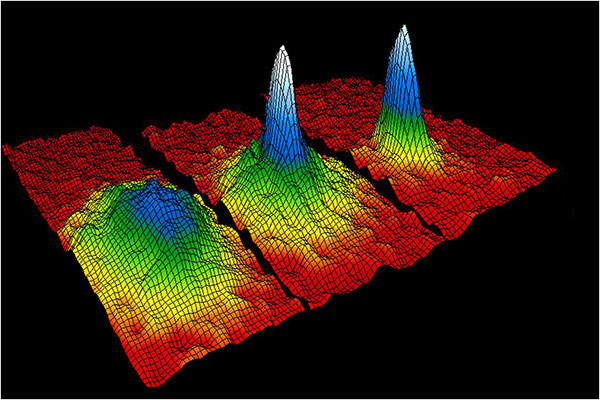
This velocity-distribution data for a gas of rubidium atoms confirmed the discovery of the Bose–Einstein condensate in 1995. In these three snapshots in time, atoms—cooled to near absolute zero—condensed from less dense areas on the left (red, yellow, and green) to very dense areas at the center and the right (blue and white). (Image: NIST/JILA/CU-Boulder)
uAvionix Corp has launched its first autopilot for unmanned aircraft systems (UAS), named George.
At 80 grams, George is a low size, weight and power (SWaP) certifiable solution for enterprise operations and those wishing to type certify their UAS. It is manufactured in the United States.
Built around the open-source autopilot Cube from CubePilot, George combines Cube with Design Assurance Level C (DAL-C) hardware and safety and sensor monitoring, enabling customers to meet the type certification and safety case requirements for beyond visual line of sight (BVLOS) operations.
George’s triple-redundant inertial measurement unit (IMU) system includes three accelerometers, three gyroscopes, three magnetometers and three barometers, one of which has been TSO-certified under TSO-C88b in other uAvionix products such as skyBeacon, tailBeacon and ping200X. The hardware platform is designed and built to RTCA DO-254 DAL-C and meets rigorous DO-160G and MIL-810H power and environmental qualifications.
George is plug-and-play compatible with all of uAvionix’s certified and uncertified products, including
truFYX GPS (TSO-C145e)
ping200X (TSO-C112e, TSO-C166b, TSO-C88b)
RT-2087/ZPX-B (AIMS MkIIB)
pingRX Pro dual-band ADS-B receiver for detect and avoid
the microLink or SkyLink C-band command and control solutions
“The flight control capabilities of the Cube are superb, backed by hundreds of thousands of man-hours of engineering and experimentation over the past 10 years,” said Paul Beard, CEO of uAvionix. “But what has been lacking is a hardware platform that matches that capability in robust performance. George brings everything we’ve learned about certified avionics to the autopilot space in a way that outperforms existing enterprise and military autopilots in a lower SWaP package.”
George will be available for beta test-launch customers in June with production units available in the third quarter.
The NTS-3 experimental satellite will be launched in 2023, according to reports from C4ISRNET and Space News. The United States military will use the satellite for positioning, navigation and timing (PNT) as a supplement to GPS.
The satellite was originally set to launch in 2022.
The Air Force Research Laboratory (AFRL) plans to use the additional time to reduce risks and conduct more ground testing.
Navigation Technology Satellite 3 will help guide future GPS satellites, a priority area for the military as the technology has become easier to spoof and jam. Among other features, NTS-3 will have steerable beams for regional coverage and a software-defined payload that can be reprogrammed on orbit.
AFRL discussed the delay in a media roundtable held Wednesday, reports C4ISRNET. AFRL Commander Brig. Gen. Heather Pringle said that shift was out of the lab’s control since the satellite will launch as a rideshare with a U.S. Space Force payload, and that launch had been pushed back.
AFRL plans to experiment with the satellite in geosynchronous orbit for one year, testing PNT signals and architectures as well as ground-based command and control systems and software-defined radios. Following testing, NTS-3 will transition to the U.S. Space Force and integrate into the service’s other PNT capabilities.
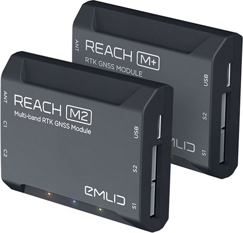
Emlid is offering two positioning modules for mapping with unmanned aerial vehicles (UAVs). Both the Reach M+ and Reach M2 provide centimeter-level accuracy in real-time kinematic (RTK) and post-processed kinematic (PPK) modes, enabling precise UAV mapping with fewer ground control points.
The Reach M+ single-band receiver has a baseline up to 20 kilometers in PPK. The Reach M2 is a multi-band receiver with a baseline up to 100 kilometers in PPK.
Usually autopilot triggers the camera and records the coordinate it has at that moment. When the drone is flying at 20 m/s and GPS works at 5 Hz, the UAV autopilot will have position readings only every four minutes, which is not suitable for precise georeferencing. In addition, there is always a delay between the trigger and the actual moment the photo is taken.
Reach solves this problem by connecting directly to the camera’s hot-shoe port, which is synced with the shutter. The time and coordinates of each photo are logged with a resolution of less than a microsecond. Reach captures flash sync pulses with sub-microsecond resolution and stores them in a raw data RINEX log in the internal memory. This method allows ground control points to be used only to check accuracy.
The Reach RS2. (Photo: Emlid)
The Reach M2 PPK UAV mapping kit consist of the Reach M2 multi-band GNSS receiver onboard the aircraft that records the location of each photo at a frequency of 20 Hz. It is combined with the Reach RS2 GNSS multi-band receiver on the ground, drastically reducing the number of ground control points and simplifying the setup process on site, while maximizing the accuracy to centimeter levels even in remote areas.
The M2 tracks GPS/QZSS (L1, L2), GLONASS (L1, L2), BeiDou (B1, B2), Galileo (E1, E5) and SBAS (L1C/A), and receives a fixed solution almost instantly.
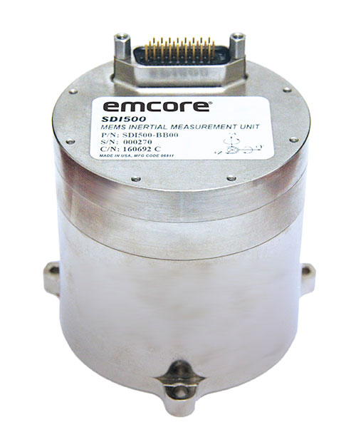
The non-ITAR status greatly increases the marketability of the SDI500/SDI505 IMUs to international customers. Plus, Emcore releases new SDI170 IMU and is awarded defense contract.
Emcore’s dual-use SDI500/SDI505 Revision F inertial measurement units (IMUs) have received a determination that they are not subject to the International Traffic in Arms Regulations (ITAR) administered by the U.S. Department of State. Emcore has likewise determined that its SDN500 inertial navigation system (INS) is not subject to ITAR.
The determination of non-ITAR status is expected to dramatically increase the size of the market that Emcore can address with its quartz micro-electro-mechanical systems (QMEMs) IMU and INS devices.
Photo: Emcore
Ranked Top in Trade Study. The SDI500/505 IMU was ranked first in overall accuracy, reported Emcore, in a U.S. military-commissioned trade study of 19 IMUs being evaluated as an alternative to the Honeywell HG1700 for various weapons systems.
The objective of the third-party independent study was to deliver a comprehensive report to the government and make a recommendation supported by clear and compelling technical, financial, and other relevant data collected regarding the most advantageous IMU products and services available in the market today. 19 IMUs of various technologies, complexity, cost, and developmental status, from leading manufacturers, were evaluated in short and long flyout simulations against the HG1700.
The dual-use non-ITAR SDI500/505 IMUs are designed to achieve the demanding performance levels required in sophisticated systems, including weapons guidance and targeting, commercial and defense fixed-wing aircraft and helicopters, unmanned autonomous vehicles (UAVs), and a wide variety of other high-precision commercial, industrial, marine, defense and space applications. They leverage quartz MEMS technology to deliver angle random walk (ARW) values of 0.02°/√hr with 1°/hr bias stability.
Defense Contract Award. In March, Emcore was awarded a development contract valued at $1.1 million by a major U.S. prime contractor to design and manufacture a high-end IMU for tactical intelligence and reconnaissance systems. The prototype phase has been successfully completed and as part of the contract in this follow-on phase, Emcore will deliver initial production units that will be used for proof of manufacturing and system level qualification.
The custom IMU will be based on Emcore’s proprietary closed-loop fiber-optic gyro (FOG) technology that delivers proven CSWaP (cost, size, weight and power) and performance advantages over other FOGs and competing technologies. It is designed to deliver the highest level of performance in Emcore’s tactical IMU product line, exceeding Emcore’s EN-300. Emcore’s FOG IMU technology delivers ten times the bias performance of legacy systems in compact form-, fit- and function-compatible packages.
New SDI170 IMU. Emcore also launched a replacement IMU. The new SDI170 quartz MEMS tactical-grade IMU is designed as a form-, fit- and function-compatible replacement for the HG1700-AG58 ring-laser gyroscope (RLG) IMU, but with superior overall performance, versatility and a significantly higher mean time between failures (MTBF) rating over ruggedized environments.
The SDI170 IMU is suitable for continuous-use applications with no wear-out components and delivers highly linear accelerometer performance and longer life compared to the HG1700 IMU. It is not ITAR controlled and has completed extensive internal and external customer testing to confirm compatibility to replace legacy products.
The unit is designed for a wide range of high-precision, integrated commercial and defense applications including aircraft Attitude Heading Reference Systems (AHRS), GPS-aided navigation, ground surveying, mobile mapping, ROVs, autonomous vehicles, tactical weapons, and stabilization platforms.
Non-ITAR Determination. As a result of this Commodity Jurisdiction (CJ) determination concluded by the U.S. Department of State, EMCORE’s SDI500/SDI505 Revision F commercial off-the-shelf (COTS) offerings were confirmed to be subject to the Export Administration Regulations (EAR) administered by the Department of Commerce (DOC). EAR classification typically results in fewer export-related restrictions and requirements. For this reason, this CJ determination for the SDI500/SDI505 will greatly increase the marketability of these IMUs to international customers.
The SDN500 is Emcore’s most advanced QMEMS INS/GPS tactical-grade system, combining the latest generation quartz gyros and accelerometers from the SDI500/SDI505, with high-speed signal processing and a 48-channel coarse/acquisition code GPS receiver into a powerful, tightly coupled guidance and navigation system.
“We would like to thank the U.S. Department of State for its evaluation of our commodity jurisdiction request and conclusion that our dual-use SDI500/SDI505 IMUs are not subject to ITAR,” said David Hoyh, Emcore’s director of sales and marketing for navigation products. “The determination of EAR status under the DOC enables more customers worldwide to benefit from these important, high-precision Emcore products.”
Adva’s OSA 5405-MB provides nanosecond timing at a network’s edge. (Photo: Business Wire)
Adva has launched the OSA 5405-MB, a compact outdoor precision time protocol (PTP) grandmaster clock with multi-band GNSS receiver and integrated antenna.
Part of the OSA 5405 series of smart synchronization devices for indoor or outdoor deployment, the OSA 5405-MB ensures timing accuracy by eliminating the impact of ionospheric delay variation. This empowers communication service providers and enterprises to deliver the nanosecond precision needed for 5G fronthaul and other emerging time-sensitive applications.
The GNSS receiver and antenna enable the OSA 5405-MB to meet PRTC-B accuracy requirements (+/-40 nanosec0nds) even in challenging conditions. For the first time, the technology is available in an edge timing device with minimal footprint, helping operators achieve unprecedented accuracy and reliability as they roll out wide-spread small cell networks.
“Our multi-band, multi-constellation GNSS receiver provides an extremely cost-efficient way to achieve PRTC-B UTC-traceable network timing with the levels of accuracy needed for next-generation use cases,” said Gil Biran, general manager, Oscilloquartz, Adva. “By adding this technology to our versatile, small-form-factor OSA 5405 series, we’re offering a route to precision synchronization at the network access without significant investment.”
“A ruggedized design and minimal visibility make our OSA 5405-MB easy to install in almost any outdoor location,” Biran said. “With the power to compensate for ionospheric delay variations and resilience against jamming and spoofing, our compact edge solution really is the key to 5G synchronization.”
The OSA 5405 series is a versatile timing solution for deployment deep in urban canyons, where advanced end applications require stringent synchronization. With its small form factor, the OSA 5405-I indoor variant can be positioned on windows to avoid multipath signal interference.
Offering both electrical and optical interfaces and with cost-effective Ethernet cabling, the OSA 5405 series avoids RF feeds of traditional GNSS installations by integrating an antenna, receiver and PTP grandmaster in a single device.
Ionospheric Delays. With multi-band GNSS technology, the OSA 5405-MB also protects against timing inaccuracies caused by ionospheric disturbance. By receiving GNSS signals in two frequency bands and using the differences between them to calculate and compensate for delay variation, the OSA 5405-MB eliminates inaccuracy and ensures ultra-precise synchronization whatever the space weather conditions.
It can work with up to four GNSS constellations concurrently (GPS, Galileo, GLONASS and BeiDou), increasing the number of observable satellites in urban canyons. A comprehensive set of Syncjack PTP and GNSS jamming and spoofing monitoring features in combination with Adva’s Ensemble Controller and Sync Director assures high synchronization quality and provides transparency for simple operation of large synchronization networks.
The OSA 5405-MB also offers network-delivered timing backup to further mitigate GNSS vulnerabilities and make synchronization more robust and resilient.
uAvionix first revealed this concept in a 2018 white paper titled “ADS-B Inert and Alert – A Solution to the ADS-B Spectrum Concerns.” The Inert and Alert Concept preserves spectrum by allowing the onboard UAS ADS-B solution to remain inert in a non-broadcasting listening mode until a safety-critical event such as a C2 lost-link or other aircraft proximity triggers it to begin broadcasting its ADS-B position as an alert. Once the conditions are safe again, the system reverts to its inert state.
“uAvionix is a firm believer in the benefits of a cooperative airspace for UAS integration,” said Christian Ramsey, president of uAvionix. “Recognizing the concerns by regulators of over-use of the spectrum, Inert and Alert is a means to leverage ADS-B for collision avoidance while significantly reducing those concerns.”
Top-level current, former PNT leaders to discuss findings
A “Who’s Who” of positioning, navigation, and timing (PNT) leaders will gather virtually at 11 a.m. PDT/2 p.m. EDT on May 5 to discuss findings of the U.S. Department of Transportation’s (DOT) GPS Backup Technology Demonstration, which took place in 2020.
Included in the “What Technologies Can Secure GPS?” webinar will be DOT Research and Technology leaders from the Obama and Trump administrations, Greg Winfree and Diana Furchtgott-Roth, and currently serving career DOT officials Karen Van Dyke and Andrew Hansen.
Robert Hampshire, current DOT Acting Assistant Secretary for Research and Technology, will make his first public appearance discussing PNT issues.
The event is sponsored by George Washington University’s Space Policy Institute and moderated by Scott Pace. Pace served as the executive director for the Space Council in the last administration. In that capacity, he was responsible for a series of directives and policies impacting PNT in the United States.
Describing the plan for the event, the formal announcement states, “Three separate laws have required the U.S. Department of Transportation (DOT) to back up and complement the Global Positioning System, subject to congressional appropriations. To provide a roadmap, in January the department released its Complementary PNT and GPS Backup Technologies Demonstration Report.”
The program will open with remarks from Scott Pace, director of the Space Policy Institute, who will also moderate the discussion. Hampshire will offer introductory remarks. Van Dyke and Hansen will follow up with a presentation of the report. George Washington University Adjunct Professor Diana Furchtgott-Roth and the Texas Transportation Institute’s Greg Winfree will provide comments.”
A question-and-answer session will follow the addresses and discussion.
The event is free and open to the public, though advance registration is required. Registrants will receive a Zoom link. The webinar will also be recorded.
Can GPS support a greener, more sustainable planet? The answer is an emphatic “yes,” and it is already doing so today.
GPS has become a fundamental technology across nearly every sector of the U.S. economy, including agriculture, transportation, construction and municipal services. In each of these industries, the use of GPS has produced substantial environmental benefits, such as lowered carbon emissions, increased water efficiency, decreased use of environmentally sensitive inputs, and reduced waste.
Agriculture
Let’s take a closer look at how GPS is protecting our nation’s critical environmental resources. We begin with agriculture where it is estimated that the absence of GPS during peak planting season could result in an economic loss of more than $15 billion, according to a National Institute of Standards and Technology report.
During the past two decades, GPS has transformed American farming, enabling increased crop yields, cost efficiencies, and environmental sustainability through the precise application of seed, water, fertilizers and pesticides and the efficient use of fuel. In sum, precision agriculture lets farmers do more with less wasted seed, less fertilizer, less fuel, less pesticide, and more crop yield.
GPS Innovation Alliance (GPSIA) founding member Deere & Company reports that precision agriculture technologies can have a huge impact on resource efficiency and sustainability. By 2030, GPS-enabled precision agriculture implemented globally could save 180 billion cubic meters of water, says the World Economic Forum.
Similarly, according to the U.S. Department of Agriculture’s Natural Resources Conservation Service (NRCS), if “[GPS] guidance systems were used on 10 percent of the planted acres in the United States, fuel use would be cut by 16 million gallons, herbicide use by two million quarts, and insecticide use by four million pounds per year.” For a single Midwest row crop farmer, with 6,500 acres using precision agriculture techniques, Deere & Company estimates that more than 1,600 gallons of fuel could be saved, and more than 400,000 kg CO2 equivalent emissions could be avoided, over the course of a production cycle — the equivalent of nearly a million (992,000) passenger car miles driven per year.
Infographic: GPS Innovation Alliance
Construction
Construction is another industry that has been revolutionized by GPS. Today, high-precision GPS is used to support the building of roads, bridges and other significant infrastructure projects. In 2019, testimony before the U.S. House Small Business Committee, an executive of GPSIA founding member Trimble described several examples of how digital construction technologies, including GPS, can more efficiently plan and execute complex construction projects.
In one such example from Southern California, the improvements “reduced the wetland impact by 58 acres; reduced the impact to sensitive species; reduced landslide risk; reduced residential displacement; and minimized the impact on existing utilities (resulting in few utility relocations to undisturbed areas).”
GPS receivers are also embedded in many bulldozers, excavators and graders, resulting in reduced waste and lower fuel consumption. They can reduce greenhouse gas emissions, with an estimate from Trimble suggesting that the use of machine control technologies can cut more than one billion pounds of CO2 usage per year.
NextGen Air
GPS is also at the heart of the Next Generation Air Transportation System, or NextGen, of the Federal Aviation Administration (FAA). Capt. Sully Sullenberger, during a 2020 GPSIA-sponsored event, described air traffic control modernization as depending “massively on the ubiquity and reliability of GPS.”
Along with the safety benefits of knowing the precise location of an aircraft, GPS enables optimized flight paths that the FAA says can reduce “flying time, fuel use, and aircraft exhaust emissions.” These efficiencies have already resulted in $1.2 billion in fuel savings, according to the FAA.
During a 2010 test flight over Puget Sound, Washington, Alaska Airlines found that the use of GPS-aided flight procedures reduced emissions by 35% compared to a conventional landing. Other airlines have also quantified these benefits, finding substantial savings in fuel consumption simply by cutting a single minute from each flight.
Weather and Disaster Forecasts
No one can argue the fact that weather events like hurricanes, floods and droughts have a huge impact on the environment and public safety. According to the National Oceanographic and Atmospheric Administration (NOAA), in 2020 such events cost $95 billion in damages. You may not realize, however, that NOAA uses GPS signals to support three-dimensional meteorology, space weather and geophysical applications throughout the United States.
Even NOAA’s Geostationary Operational Environmental Satellites (GOES) use GPS signals to enhance their ability to provide the data we all receive in each morning’s TV weather forecast, improving weather predictions and our own storm situational awareness. GPSIA member Lockheed Martin manufactures both the GOES-R series of weather satellites and the U.S. Space Force’s more powerful, next-generation GPS III satellites that are now being launched to modernize the GPS constellation.
Municipalities
Lastly, we examine the environmental benefits for municipalities that use GPS for key government services, including the real-time tracking of garbage trucks, snowplows and buses. Throughout the country, towns and cities have seen substantial savings in dollars, fuel and time from implementing GPS-enabled technologies.
In Niles, Illinois, for example, the Department of Public Works partnered with GPSIA founding member Garmin to optimize the routing of snowplows. Using GPS technology, drivers reduced the use of salt by as much as 40%, resulting in more than 700 tons saved. In 2020, in recognition of its innovative use of GPS, the department received the Management Innovation Award from the American Public Works Association. Similarly, GPSIA member CalAmp found that GPS use for vehicle tracking can result in fuel savings of $90 per vehicle per month.
Ensuring GPS
Ensuring these environmental benefits can continue to be realized requires that the spectrum used by GPS be protected from harmful interference. It will also depend on continued funding by Congress to modernize the GPS constellation and ground control. Additionally, as Congress considers a major infrastructure bill, including funding for states and localities, we would encourage projects to make use of GPS and other innovative technologies that can drive down costs, reduce carbon emissions, and eliminate waste — including advanced digital-construction management systems that use GPS data to reduce project costs and speed project delivery.
GPS has changed our everyday lives for the better, and as our dependence on this technology continues to grow, so will its impact on environmental sustainability efforts.