The end of 2020 marked a milestone for the Galileo First Generation, as the program chalked up its 500th European Space Agency (ESA) Engineering Board.
For more than 12 years, ESA and industry engineers from all relevant disciplines — system, satellite, ground, signal, radio navigation, RAMS (reliability, availability, maintainability and safety), security and infrastructure — have put their best skills at the disposal of the board.
The board is a forum where technical experts regularly meet to maintain, review and update the Galileo Project technical baseline, known as the System Technical Requirements Baseline (STRB). The STRB drives the implementation of the Galileo System and its infrastructure, the space and ground segments, along with associated interfaces and operations.
The G1 system technical specification under ESA adds up to more than 22,000 separate requirements. These requirements are both unclassified and classified, with considerable interdependencies which all that need to be controlled in configuration.
The Galileo G1 Engineering Board is chaired by ESA in accordance with its role as Galileo System Design Authority, assigned to it by the European Commission.
Since the building of the first G1 Engineering Board in 2008, 26 Galileo satellites have been built, tested and flown. The Galileo system’s globe-spanning ground system has also been put in place and made operational. The board continues to be a crucial enabler for further robustness improvements and new service evolutions.
A further 12 Batch 3 satellites are set to join the constellation in the coming decade. These satellites are being finalized at OHB Systems in Bremen, Germany, and then tested at ESA’s ESTEC Test Centre in the Netherlands.
The worldwide Galileo ground segment includes two control centers (Italy and Germany) as well as various tracking, uplink and sensor stations and monitoring and test centers. (Image: ESA)
Galileo began initial operations in December 2016 and today serves more than 1.5 billion smartphones and devices.
The G1 Engineering Board meetings will continue, complemented with Engineering Boards for the new Galileo Second Generation (G2 satellites are planned for later this decade), which are already well underway.
Lockheed Martin Space has released the GPS-III satellite antenna phase-center data, as well as the group delay and inter-signal correction data, for SVN-76 and SVN-77 as measured at the factory, announced the U.S. Coast Guard’s Civil GPS Service Interface Committee (CGSIC).
The phase center and inter-signal bias data included in this new release provide additional information that supplements the antenna gain pattern data previously available.
Note that the GPS III satellite vehicles (SVNs) also broadcast the Inter-Signal Corrections (ISCs) in the various LNAV/CNAV messages in accordance with all the external IS/ICDs. The value that is being broadcast by the on-orbit constellation is not the factory measured ISCs but the ISCs estimated on-orbit by the Stanford Research Institute (SRI).
As we embark on a new year, 2021 ushers in a new administration and the start of the 117th Congress. With these changes comes a litany of opportunities, as well as challenges, for the nearly four-decade-old GPS industry.
Next month, the GPS Innovation Alliance (GPSIA) will mark its eighth anniversary as the voice of the GPS industry, educating policymakers and regulators about the GPS success story of innovation, economic growth and job creation. It is a uniquely American story made possible because of bipartisan support for protecting the spectrum used by GPS and maintaining funding to enable the modernization of the GPS constellation, ground control and military ground user equipment.
Congressional Support. This commitment was evident in the last Congress through broad support from both parties for two Congressional resolutions, H.Res.219 and S.Res.216, that affirmed the importance of continuous availability, accuracy, efficiency, robustness, reliability and resiliency of the GPS constellation.
Innovation and modernization of the GPS constellation are well underway. Last year, under the emerging leadership of the U.S. Space Force, two new Lockheed Martin-built GPS III satellites were launched into space. This new generation of GPS satellites offers three times greater accuracy, up to eight times improved anti-jamming capability for military users, and the addition of the L1C signal to enable interoperability with other navigation systems, such as Europe’s Galileo.
GPS modernization also has led to the introduction of M-code, an advanced, new signal designed to improve anti-jamming and anti-spoofing, as well as to increase secure access to military GPS signals for U.S. and allied armed forces. In GPS-denied environments, M-code reduces the jamming radius, giving military planners and targeteers options to minimize or avoid collateral strike damage.
With at least two additional GPS III satellites set to launch this year and a new ground control segment known as the Next Generation Operational Control System (OCX), the continued success of the GPS program remains bright.
Ligado Still Looms
As GPSIA continues to urge Congress to allocate the funding needed to support the modernization of GPS, we also are fighting to ensure uninterrupted operation of the estimated 900 million GPS devices in the United States ranging from precision agriculture to consumer gadgets.
Last year, we were deeply disappointed by the Federal Communications Commission’s (FCC) decision approving the applications of Ligado Networks, despite the well-documented objections of the expert agencies charged with preserving the integrity of GPS, specifically, on the critical issue of what constitutes harmful interference to users of GNSS.
Regrettably, the FCC chose to ignore the established “1-dB Standard,” which has a long history of protecting GPS operations from harmful interference in both international and domestic regulatory proceedings.
“All Americans benefit from a competitive 5G landscape.”
At the same time, Ligado and its supporters continue to argue that their proposal is the fastest way to bring 5G to all Americans. In actuality, millions of Americans already have access to 5G services and, thanks to the efforts of the FCC, hundreds of megahertz of 5G spectrum in low-, mid- and high-band frequencies have been or will soon be made available for commercial use. GPSIA believes all Americans benefit from a competitive 5G landscape.
5G without compromise. However, that goal can be achieved without undermining GPS receivers and devices that are foundational to wireless technology in general, including 5G. We remain hopeful that a new administration and congress will commit to protecting GPS receivers from harmful interference using the appropriate standard for determining such interference to ensure that the more than $1 billion per day in U.S. economic impact created by GPS continues to flourish.
2020 also brought the issue of GPS resiliency into the national forefront. In February, the president signed an Executive Order aimed at fostering greater resiliency for positioning, navigation and timing (PNT)-based systems, including GPS.
GPSIA supported this order and outlined in subsequent regulatory filings why GPS remains the gold standard for delivering PNT functions to our military as well as a wide range of other sectors, including transportation, agriculture, electricity and finance.
Complementing GPS. As the federal government considers alternative PNT solutions, it is critical that they be complementary to GPS, able to easily integrate into current or future devices, and based on a recognition that each PNT application has unique requirements driven by its intended function, environment and design factors. In sum, there is no one-size-fits-all solution.
Protecting Consumer Privacy. Looking ahead, GPSIA expects 2021 will bring a robust discussion around consumer privacy protections. While GPS satellite broadcasts are one-directional and cannot track a user’s location, we recognize that GPS is one of many data points that can contribute to application-specific location tracking. As such, GPSIA would urge Congress to ensure that geolocation data is appropriately addressed as part of any U.S. federal privacy legislation. In doing so, we believe protections for precise geolocation information will empower consumer choice, enhance transparency, and strengthen security.
On the surface, infrastructure modernization, protecting GPS spectrum, PNT resiliency, and consumer privacy may seem like distinctly different issues. What they have in common, though, is an ability to garner bipartisan support, deliver substantial consumer benefits, and strengthen our nation’s economy. GPSIA stands ready as a resource and looks forward to working with the Biden-Harris Administration and leaders in the House and Senate to promote, protect and enhance GPS.
Germany is the first United States ally to order the new military code (M-code)-capable Military GPS User Equipment (MGUE).
The Space and Missile Systems Center’s Space Production Corps achieved the major milestone on Sept. 30, when GPS Foreign Military Sales (FMS) office received its first M-code MGUE order.Germany is expected to receive delivery of its first M-code receivers this year.
SMC is facilitating international access and availability of M-code user equipment as directed by the Secretary of the Air Force and the Office of the Secretary of Defense to 58 authorized nations. Additional foreign military sales of MGUE are being worked.
Currently, SMC is engaged with several nations in bilateral M-code prototyping, demonstration and lead platform planning efforts. Under a multilateral agreement, MGUE ground-based receivers are on schedule to be loaned to approved partners for early integration and test in national weapons systems.
M-code is an upgrade to the currently available GPS signals that provides enhanced secure positioning, navigation and timing (PNT) performance, anti-jam and anti-spoofing to provide a more resilient PNT solution. It will improve interoperability with our defense partners’ equipment and operations while increasing navigation warfare effectiveness for allied operations.
Teledyne Technologies will acquire FLIR Systems in a cash and stock transaction valued at $8 billion, both companies announced on Jan. 4.
Teledyne is a provider of sophisticated instrumentation, digital imaging products and software, aerospace and defense electronics, and engineered systems. Its operations are primarily in the United States, Canada, the United Kingdom, and Western and Northern Europe.
Founded in 1978, FLIR is an industrial technology company focused on intelligent sensing solutions for defense and industrial applications.
Under the terms of the agreement, FLIR stockholders will receive $28 per share in cash and 0.0718 shares of Teledyne common stock for each FLIR share, which implies a total purchase price of $56.00 per FLIR share based on Teledyne’s five-day volume weighted average price as of December 31, 2020. The transaction reflects a 40% premium for FLIR stockholders based on FLIR’s 30-day volume weighted average price as of Dec. 31, 2020.
As part of the transaction, Teledyne has arranged a $4.5 billion 364-day credit commitment to fund the transaction and refinance certain existing debt. Teledyne expects to fund the transaction with permanent financing prior to closing. Net leverage at closing is expected to be approximately 4.0x adjusted pro forma EBITDA with leverage declining to less than 3.0x by the end of 2022.
Teledyne expects the acquisition to be immediately accretive to earnings, excluding transaction costs and intangible asset amortization, and accretive to GAAP earnings in the first full calendar year following the acquisition.
“At the core of both our companies is proprietary sensor technologies. Our business models are also similar: we each provide sensors, cameras and sensor systems to our customers. However, our technologies and products are uniquely complementary with minimal overlap, having imaging sensors based on different semiconductor technologies for different wavelengths,” said Robert Mehrabian, executive chairman of Teledyne. “For two decades, Teledyne has demonstrated its ability to compound earnings and cash flow consistently and predictably. Together with FLIR and an optimized capital structure, I am confident we shall continue delivering superior returns to our stockholders.”
“FLIR’s commitment to innovation spanning multiple sensing technologies has allowed our company to grow into the multi-billion-dollar company it is today,” said Earl Lewis, chairman of FLIR. “With our new partner’s platform of complementary technologies, we will be able to continue this trajectory, providing our employees, customers and stockholders even more exciting momentum for growth. Our board fully supports this transaction, which delivers immediate value and the opportunity to participate in the upside potential of the combined company.”
“We could not be more excited to join forces with Teledyne through this value-creating transaction. Together, we will offer a uniquely complementary end-to-end portfolio of sensory technologies for all key domains and applications across a well-balanced, global customer base,” said Jim Cannon, FLIR president and CEO. “We are pleased to be partnering with an organization that shares our focus on continuous innovation and operational excellence, and we look forward to working closely with the Teledyne team as we bring our two companies together to capitalize on the important opportunities ahead.”
Fourth-quarter financial results. In a separate press release issued today, Teledyne announced improved preliminary financial results for the fourth quarter and full year 2020. The Teledyne press release is available on www.teledyne.com. FLIR noted today that it expects to meet or exceed the full year fiscal 2020 guidance it provided on Oct. 30.
Approvals and timing. The transaction, which has been approved by the boards of directors of both companies, is expected to close in the middle of 2021 subject to the receipt of required regulatory approvals, including expiration or termination of the applicable waiting period under the Hart-Scott-Rodino Antitrust Improvements Act, approvals of Teledyne and FLIR stockholders and other customary closing conditions.
Advisors. Evercore is acting as exclusive financial advisor and McGuireWoods LLP is acting as legal advisor to Teledyne in connection with the transaction. Goldman Sachs & Co. LLC is acting as exclusive financial advisor and Hogan Lovells US LLP is acting as legal advisor to FLIR in connection with the transaction. Teledyne has entered into a 364-day senior unsecured bridge facility credit agreement with Bank of America as sole lead arranger and administrative agent.
Conference call and webcast. Teledyne and FLIR hosted a conference call to discuss the acquisition. A replay is available and will be available for one month.
The IGS Workshop, scheduled for September 2021 by the International GNSS Service (IGS), has been postponed to 2022. The IGS Central Bureau voted for the postponement in December during its governing board meeting.
The IGS Workshop, originally intended to take place 2020, was postponed to 2021 because of travel restrictions associated with COVID-19. The dates of the workshop will be determined later.
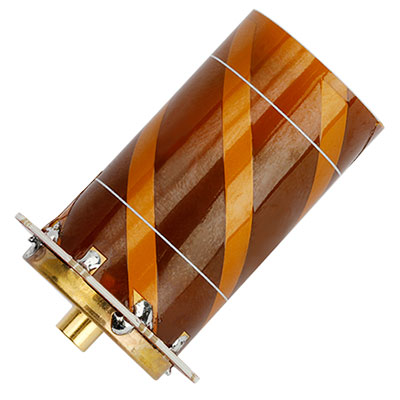
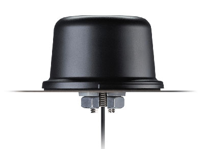
Tallysman Wireless has introduced two lightweight and compact active Iridium helical antennas designed to receive Iridium Satellite Time and Location (STL) signals.
The signals are used by STL terminals to provide worldwide position, navigation and timing independent of GPS/GNSS via an encrypted satellite broadcast signal that is strong and secure and can also be received indoors.
Because GNSS signals may be jammed (intentionally or accidentally) and spoofed, STL signals are a reliable alternative to augment and authenticate time for applications, such as electrical grids, wireless communications networks and financial systems, as well as position for private and public infrastructure.
The housed HC610 and embedded HC610E active Iridium antennas operate in receive-only mode and enable Iridium terminals to be installed tens of meters away from the antenna.
Photo: Tallysman
Both antennas are light and compact and feature a precision-tuned helical element that provides an excellent axial ratio and operates without a ground plane. They also feature a low-current, low-noise amplifier (LNA) and pre-filter to prevent harmonic interference from high-amplitude signals, such as 700-MHz band LTE and other nearby in-band cellular signals.
The housed HC610 weighs 23 grams, is 33 x 54.2 mm, and features an IP67 robust, military-grade plastic enclosure, with a base-mounted male SMA connector and two screw holes for surface attachment.
At 10 grams, the embedded HC610E is 27.5 x 38.7 mm and can be installed in a custom enclosure. It provides a base-mounted female MCX connector. An optional embedded helical mounting ring is available to attach the antenna to a flat surface.
Tallysman also provides support for the installation and integration of embedded helical antennas to enable successful implementation and to ensure optimal antenna performance.
A roundup of recent products in the GNSS and inertial positioning industry from the December 2020 issue of GPS World magazine.
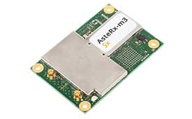
OEM
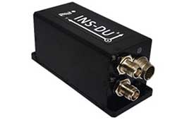
Inertial system
Ready for UAVs, robotics
Photo: Inertial Labs
The INS-DU is a high-performance strapdown inertial navigation system (INS) that determines position, velocity and absolute orientation of a platform it is mounted to. Its dual-antenna u-blox receiver provides 1-cm real-time kinematic (RTK) position from RTCM 3 RTK corrections and supports multiple GNSS constellations. Designed for UAVs, land vehicles and marine vessels, the INS-DU uses a range of aiding data to deliver a highly accurate solution for GNSS-denied environments. It uses a miniAHRS with 3-axes each of precision magnetometers, accelerometers and gyroscopes to provide orientation. It contains algorithms for the motion of robots, autonomous vehicles and antennas.
The high-accuracy tactical-grade STIM277H gyro module and STIM377H inertial measurement unit (IMU) were designed to meet space segment needs. Both have hermetic aluminum enclosures, and all parts are tested for fine and gross leak to conform to MIL-STD-883J, Class H. While a commercial off-the-shelf (COTS) product, Sensonor has carried out extensive radiation characterizations. The design is tested for a 20+ years operating life through high-temperature operating life (HTOL) testing. Backwardly compatible with Sensonor’s other IMU and gyro modules, STIM277H and STIM377H are designed for satellite attitude and orbit control systems (AOCS), launchers, portable target acquisition systems, UAV payloads, land navigation systems, turret stabilization, missile stability and GNSS-supported navigation systems.
The AsteRx-m3 family features GPS/GNSS OEM boards optimized for power consumption and ease of integration. An easy-to-integrate design enables short set-up times and faster time-to-market. The AsteRx-m3 offers multi-frequency, multi-constellation positioning combined with Septentrio’s GNSS+ technology while optimizing power. The AsteRx-m3 Pro rover receiver tracks signals from all available GNSS constellations on three frequencies, and operates both in single- and dual-antenna modes. The AsteRx-m3 ProBase is designed to operate as a reference station for RTK and PPP-RTK networks. The AsteRx-m3 Pro+ is a full-feature OEM receiver board flexible enough to fit into any application and to be used either as a rover or a base station in a single- or dual-antenna mode.
New anti-jamming antennas available are the QR200 GPS dual-frequency L1/L2 anti-jamming antenna, the QR201 GNSS multi-frequency band anti-jamming antenna, and the QR202 GNSS multi-frequency band anti-jamming antenna with additional L-band reception (1520–1560 MHz). All models provide robust GPS or GNSS navigation and block intentional jamming and unintentional RF interference timing or 3D positioning. All three are lightweight (230 grams for the QR1xx series and 500 grams for the QR2xx series) with low power consumption (1–1.5W typically, depending on configuration), and can be mounted on any platform (cars, poles, drones, etc.).
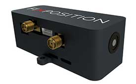
The Vision-RTK positioning sensor is a compact centimeter-accurate solution with high reliability and availability in challenging environments. The module integrates two real-time kinematic (RTK) GNSS receivers and visual inertial navigation. Its sensor-fusion algorithm is based on deep integration of GNSS, camera and inertial sensors. Real-time sensor fusion provides centimeter-accurate absolute positioning in any outdoor environment.
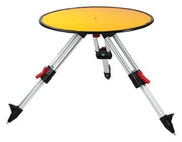
Deploying ground control targets on accurately surveyed ground control points (GCP) assures that a UAV lidar survey has been properly executed. UAV lidar surveys are typically undertaken in remote, rural and sometimes hazardous locations where no fixed points are available, such as solid surfaces or concrete features. Routescene’s GCPs are raised from the ground using a mini tripod. A built-in bubble level enables accurate leveling and removes the need for a tribrach. Robustly engineered, the targets stay in position during adverse and windy conditions, reducing the risk of repositioning during a survey. They are covered with highly retro-reflective material to provide high-intensity returns. As a result, the targets are easily identifiable and can be automatically extracted from the geo-referenced point cloud.
The Toughbook A3 Android tablet is aimed at the mobile workforce. It has an outdoor viewable screen and patented rain-touch functionality. With a 10.1-inch screen and 6-foot drop rating, the A3 enables users across industries to tackle tough jobs and critical applications. The Qualcomm SDM660 chipset, which supports BeiDou, Galileo, GLONASS, GPS, BeiDou QZSS and SBAS. 4G LTE Band 14 EM7511 multi carrier mobile broadband with GPS. The tablet has a powerful octa-core processor, an optional integrated barcode reader, an insertable smart card reader and an insertable stylus. The A3 has a 5-foot drop rating and IP65 certification for dust and water resistance.
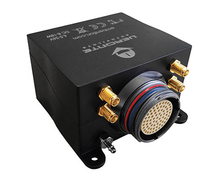
Veronte Autopilot 1X is a miniaturized avionics system for advanced control of unmanned systems. The control system embeds a suite of sensors and processors with datalink radio, with reduced size and weight. The control system Veronte Autopilot 1X adds fully autonomous control capabilities to any unmanned system for complete operation. The Veronte control system is fully configurable for payload, platform layout, control phases and control channels. It uses real-time kinematic (RTK) positioning and provides cloud connectivity, sense-and-avoid support, electromagnetic interference and vibration isolation.
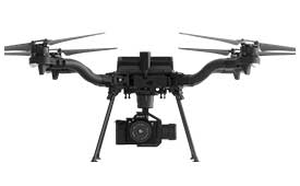
The Astro commercial drone platform is equipped with Freefly’s multi-band, real-time kinematic (RTK) system, which provides centimeter-level precision with a u-blox F9P GNSS module. The drone is equipped with a 60-megapixel Sony camera. A customized version of Skynode powers each Astro, providing LTE connectivity, an onboard Linux mission computer, and seamless connectivity to Auterion Mission Control and Cloud Suite. The Auterion ecosystem provides robust, secure and scalable drone planning, flight and compliance management solution.
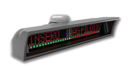
The guidance system AgPilotX for aerial applicators uses three wireless components: a GPS/GNSS lightbar, a hub and an Apple iPad. The smart components run off their own computer, communicating to each other wirelessly. The AgPilotX Smart Lightbar has onboard GPS+GLONASS as well as a GNSS antenna, so there is no need to run an antenna up to the aircraft canopy. The Lightbar logs the data, while a hub connects the switches (swath advance, swath decrement, spray on/off) and peripherals, and an iPad runs the interface software through an Apple App. All logs are saved as unique jobs and can be returned to at any time. The lightbar is not dependent upon the iPad to operate and will continue to work the active job even if you start using a different App or even shut the Apple device completely off.
Insero, inserosolutions.com
Antennas
High accuracy for autonomous vehicles, robotics
The Colosseum X XAHP.50 antenna. (Photo: Taoglas)
Two new active, multiband GNSS antennas are engineered for applications that require critical high-accuracy positioning and timing, including autonomous driving and precision agriculture. The MagmaX2 AA.200 is designed for space- and weight-constrained applications, such as robotic lawnmowers. Embedded versions are also available. It is a low-profile active multiband GNSS magnetic mount antenna for use across most major constellations including GPS (L1/L2/L5), GLONASS (G1/G2/G5), Galileo (E1/E5a/E5b) and BeiDou(B1/B2). The Colosseum X XAHP.50 is a geodetic-quality small-dome antenna suitable for a vehicle roof mount or pole mount. It is engineered to operate with high-precision capabilities on the full GNSS spectrum. Sub meter positional accuracy better than 55 cm is achievable, even without the use of RTK correctional services.
A new start-up has introduced an autonomous lawn mower to bring intelligence, automation and sustainable solutions to commercial landscaping. The first autonomous lawn mower by Graze is set to hit the market this year.
The electric lawn mower is designed to increase efficiency and maintenance speed for mid- to large-sized commercial lawns, enhance cutting blades to perfect trim precision, add new sensor capabilities to increase safety, and improve GPS-based mapping and computer vision while optimizing intelligent and applicable insights through advanced machine-learning capabilities.
Analyst reports have found landscaping services in the U.S. generated $101.7 billion in revenue in 2020, while commercial landscaping services (maintenance and general services) have been projected to range between 40 and 60 percent of the overall landscaping service industry in the U.S. Yet, despite the major opportunity to capitalize on an approximate $53B market, commercial lawn mowing has remained an undisrupted industry. Small margins, labor limitations and increasing scrutiny on environmental impact has been met with a lack of impactful solutions.
Graze’s initial prototype attracted investors from major operators as well as individuals on crowdfunding platform SeedInvest.
“We are living in new era of artificial intelligence that stands to transform age-old industries,” said John Vlay, Graze Mowing CEO. “Robotics and automation open up a world of efficiency, and when you apply intelligence, traditional models can be completely reimagined. I’ve been in commercial landscaping for more than 35 years, and can confidently say we built a lawn mower that will bring a new level of quality and safety to the market, and we are doing it sustainably. We are excited to unveil the future of commercial lawn-mowing with our new Graze commercial mower.”
The new model optimizes features and incorporates in-the-field feedback. It has a longer battery life. It can consistently learn and apply data via an intuitive user experience, improving lawn care and creating new optimization opportunities for fleet operators.
Machine learning, coupled with computer vision and a robust system of sensors, allows the new Graze commercial mower to map job sites, plan and execute mowing paths, and avoid obstacles and dangerous inclines while continuously collecting and apply data to further improve aesthetic quality and efficiency.
Powered completely by electric and solar panel technology, the new model allows operators to maximize revenue by deploying mowers during evening hours. Fuel costs are drastically cut, as are carbon emissions. Current fleet operators manage 500 to 1,000 mowers.
Graze is backed by lead investor Wavemaker Partners, a global venture capital fund with $400 million in assets under management including Wavemaker Labs, a robotics and automation focused venture studio.
Emlid has debuted the Reach RS2, a fully-featured multi-band RTK receiver. All of its features are available out of the box, along with a survey app for iOS and Android.
The Reach RS2 tracks L1/L2 bands on GPS, GLONASS and BeiDou, and L1/L5 on Galileo, and acquires a fixed solution in seconds. It achieves centimeter-level precision for surveying, mapping and navigation and maintains robust performance even in challenging conditions. Centimeter accuracy can be achieved on distances up to 60 km in RTK and 100 km in PPK mode.
Up to 22 hours of autonomous work when logging data and up to 16 hours as a 3G rover, even in cold weather—no more need to carry spare batteries with you. Reach RS2 can charge from a USB wall charger or a power bank over USB-C.
Reach RS2 comes with a free app for iOS and Android called ReachView, which supports thousands of coordinate systems worldwide. With ReachView, users can fully configure their Reach receiver, enable RINEX data logging, and survey in RTK.
Reach RS2 also features a power-efficient 3.5G HSPA modem with 2G fallback and global coverage. Corrections can be accessed or broadcast over NTRIP independently, without relying on an internet connection on a smartphone.
Base for RTK Drone. The Reach RS2 can be used as a base station for drone mapping, using an RTK drone such as the DJI Phantom 4.
A new service offered by Emlid is Emlid Caster, a free way to pass corrections between receivers over the internet. Emlid Caster works with any NTRIP-capable device.
E38 Survey Solutions, an Emlid dealer in the United States, conducted a case study with the Reach RS2.
Senate poised to join House this week and override Trump’s veto
The U. S. Congress, especially the Armed Services Committees, have long been concerned about GPS and positioning, navigation, and timing (PNT) issues. Over the last two decades Congressional hearings, demands for reports, and investigations have dealt with acquisition, contingency plans for when space is not available, deliberate interference, and a host of other issues.
While these all evidenced Congress’ interest and concern, they were relatively passive measures.
The NDAA for 2021 seems to finalize Congress’ transition from an interested observer, mostly on the sidelines, to an active player in national PNT issues and policy.
This began to change in 2018 with passage of the National Timing Resilience and Security Act. It requires the Department of Transportation to establish a terrestrial timing system to backup GPS signals.
Then in 2019, Congress appropriated money for a GPS Backup Technology Demonstration. And the National Defense Authorization Act (NDAA) for 2020 required the Air Force to develop a prototype multi-GNSS receiver as part of its resiliency efforts.
The NDAA for 2021 seems to finalize Congress’ transition from an interested observer, mostly on the sidelines, to an active player in national PNT issues and policy.
Capitol Hill observers say this is the result of several things that have come to a head over the last year. Taken together, they have convinced many legislators that GPS is under threat and PNT issues are not being taken seriously enough by the executive branch. These include increased jamming and spoofing (especially by China and Russia), full implementation of China’s BeiDou system and its marketing to other nations as a superior alternative to GPS, the Federal Communications Commission’s (FCC) decision on Ligado Networks, and the Pentagon’s failure to respond to combatant commanders’ Joint Urgent Operational Needs Statements for non-GPS PNT.
Photo: Andrea Izzotti/Shutterstock.com
Here are some of the provisions of the 2021 NDAA of interest to the PNT community.
Military Multi-GNSS Receiver Prototype
The 2018 NDAA required the Defense Department to incorporate Europe’s Galileo and Japan’s QZSS satellite navigation signals into military user equipment. The idea was to make it more resilient to disruption. Also required was an investigation into using non-allied signals.
Apparently not satisfied with progress on this project, Congress mandated a project to develop a prototype multi-GNSS receiver as part of the 2020 NDAA.
The 2021 NDAA seems to indicate the Congress is still not happy. It withholds 20% of the funding for the Office of the Secretary of the Air Force until such time as the department certifies the prototype project is underway and provides briefings to the Senate and House Armed Services Committees.
Resilient Survivable PNT
Language in the 2021 NDAA also seems to show Congress is impatient with the Pentagon’s lack of responsiveness to combatant commanders’ requests for non-GPS PNT systems.
Section 1611 of the Act is entitled “Resilient and Survivable Positioning, Navigation, and Timing Capabilities.” It requires development, integration, and deployment of these capabilities for combatant commanders within two years. This, it says, is “… consistent with the timescale applicable to joint urgent operational needs statements…”
The act says the new PNT capabilities shall “generate resilient and survivable alternative positioning, navigation, and timing signals” and “process resilient survivable data provided by signals of opportunity and on-board sensor systems.”
The act also reverses the Defense Department’s 2018 PNT Strategy’s plan for future systems to be classified and for military use only. It directs the department to work with the National Security Council, Departments of Transportation, Homeland Security and others “to enable civilian and commercial adoption of technologies and capabilities for resilient and survivable alternative positioning, navigation, and timing capabilities to complement the global positioning system.”
To help ensure prompt action on this, the act requires a report to Congress within six months and authorizes the department to reprogram funds from other areas to finance the effort.
Responding to FCC’s Decision on Ligado Networks
By far the most PNT-related text in the 2021 NDAA includes a host of measures responding to FCC Order 20-48 approving an application by Ligado Networks. An order which the executive branch is on record as strongly opposing saying it will degrade GPS service for many.
Senator Jim Inhofe, chair of the Senate Armed Services Committee, has regularly expressed outrage at the FCC’s decision and has called for its reversal.
Among its provisions the act:
Requires the Department of Defense to estimate and report to Congress the cost of damage to department systems as a result of the FCC order.
Prohibits using department funds to upgrade or modify military equipment to make it resilient to interference caused by broadcasts in the spectrum allocated (the FCC order requires this to be funded by Ligado)
Prohibits contracting with any entity using the frequency bands allocated to Ligado unless the Secretary of Defense certifies the use will not interfere with GPS services
Requires the Secretary of Defense to contract with the National Academies of Sciences, Engineering, and Medicine for an independent technical review of the FCC order.
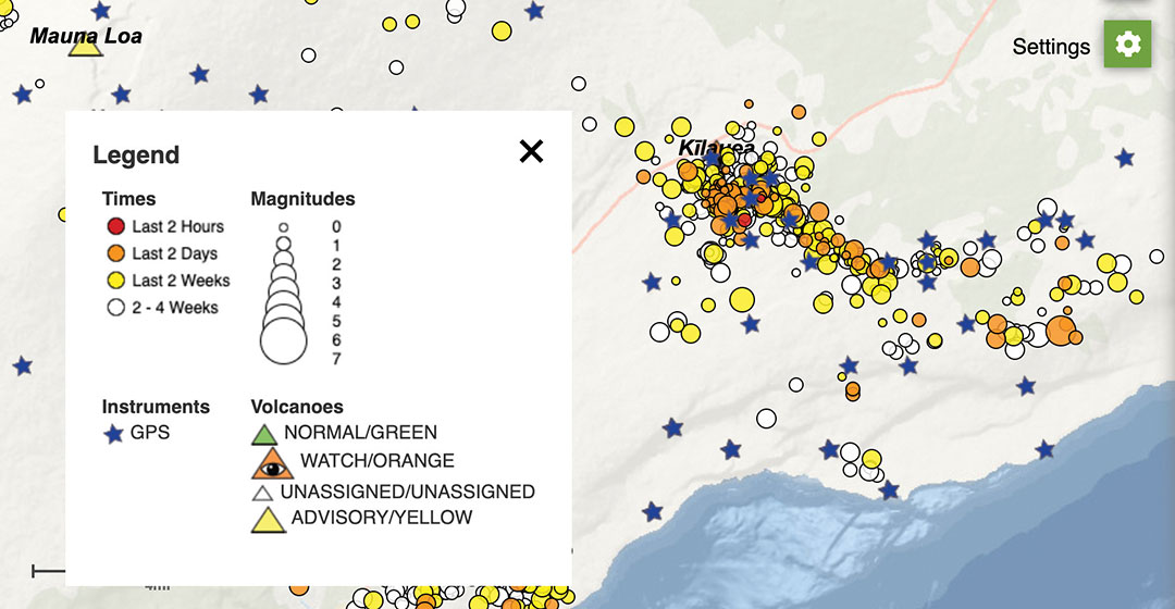
Beginning in September, GPS stations in Kilauea’s upper East Rift Zone observed increased rates of uplift, higher than they have been since the end of the eruption in 2018. According to the U.S. Geological Survey’s Hawaiian Volcano Observatory, earthquake rates increased in late November.
On Dec. 2, GPS stations and tiltmeters recorded a ground deformation quake at Kilauea’s summit accompanied by earthquake swarms.
Then on Sunday, Dec. 20, a magnitude 4.4 earthquake struck on Kilauea’s south flank and three fissure vents broke open inside the caldera. Fountaining lava at these vents is estimated to be up to 82 feet high. The vents are feeding lava flows into the base of Halema‘uma‘u crater, which is being filled with lava. The lava lake has been rising several yards an hour since the eruption began at 9:36 p.m. Sunday. The eruption is currently confined to the crater.
According to the observatory, “The water lake at the summit of KIlauea has boiled away and an effusive eruption has commenced, with three vents in the wall of Halema‘uma‘u crater generating lava flows that are contributing to a growing lava lake at the base of the crater.”
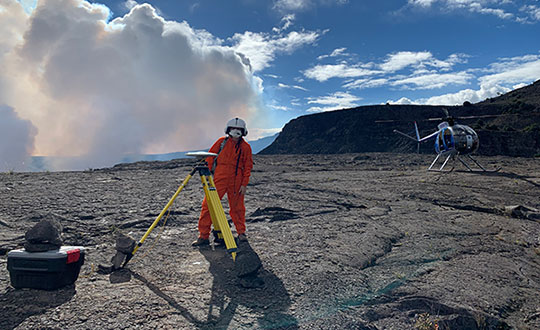
As of Dec. 29, the summit eruption continued with the western vent active (the other vents have been covered by the lava lake). At 3:45 a.m. HST, field crews measured the lava lake as 179 meters (587 feet) deep, about 650 feet below the rim.
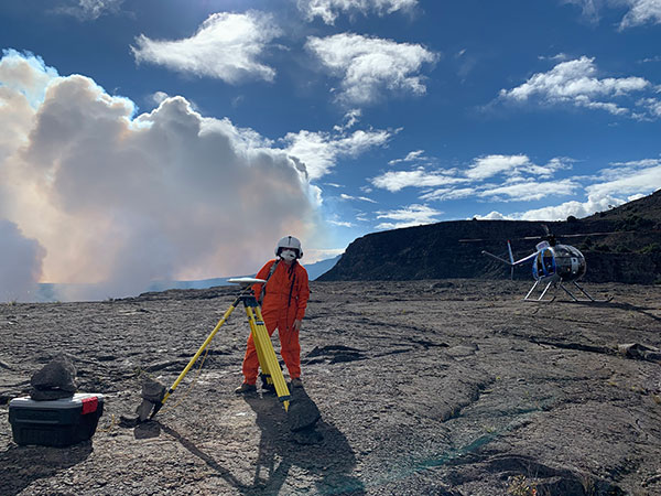
Shortly after 9:30 p.m. HST Dec. 20, an eruption began at the summit of Kīlauea Volcano in Hawaii. Red spots indicate fissure vents feeding lava into the bottom of Halema‘uma‘u crater. Lava coverage is 32 feet higher than the water in this photo (base map is from imagery collected on Sept. 23, 2020).The water lake at the base of Halema‘uma‘u crater has been replaced with a growing lava lake. View from the west rim of Kīlauea Caldera just before 5 a.m. HST on Dec. 21, 2020. A 59-foot fountain joins two other fissures to feed a growing lava lake at the base of Halema‘uma‘u crater. (Photo: USGS)The interactive USGS monitoring map shows GPS stations situated on and around Kilauea as well as volcano activity. (screenshot taken at 12 p.m. HST on Dec. 21).An HVO geophysicist deploys a GPS receiver on the Kilauea caldera floor to measure changes in ground motion. A volcanic gas plume rises in the background. GPS and tiltmeter data show contraction in the upper portion of the East Rift Zone (an area between Kīlauea’s summit and Pu‘u ‘Ō‘ō). (Photo: USGS)