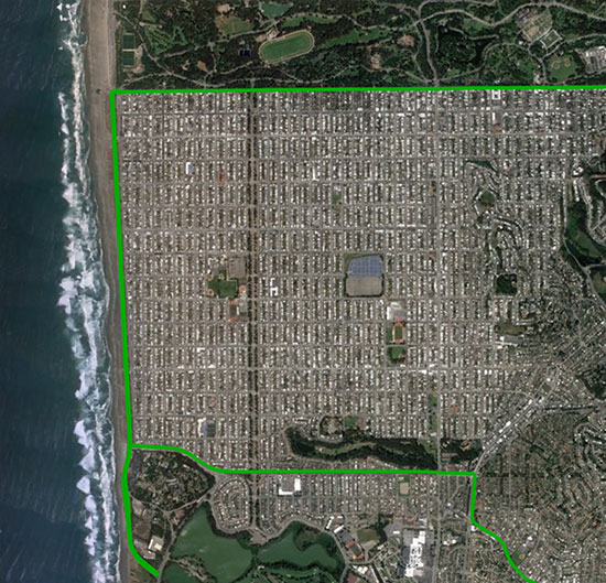
The mixed urban environment in San Francisco, where Starling + the TeseoAPP was tested and data collected and processed in real time. (Image: Swift Navigation)
The Starling modular and portable GNSS high-precision positioning engine leverages Swift’s Skylark Cloud Corrections Service. An advanced GNSS processing engine, Starling enhances measurements from commercially available GNSS receivers to provide true precision and integrity capabilities, the company said.
Starling is GNSS-receiver agnostic and works with a variety of automotive grade GNSS chipsets and inertial sensors, offering automotive companies choices in selecting the best components for their autonomous sensor suite, vehicle-to-vehicle (V2V) applications and automated driving systems.
In a test drive in California, Swift showcased the integration of Starling onto ST’s Telemaco3P MPU-based modular telematics platform with on-board TeseoAPP, confirming the accuracy of the combined solution as a compelling offering for safety-critical autonomous-vehicle positioning when ST makes production TeseoAPP chipsets available in 2019.
Skyworks Solutions‘ advanced wireless engines are enabling Philips’ CityTouch end-to-end street lighting management platforms.
Specifically, Skyworks’ connectivity solutions provide efficiency, extended range and complete network coverage to facilitate seamless communication between Philips’ smart street lamps and cellular base stations.
The innovative devices allow city operators to reduce power consumption and support public safety through adaptive scheduling and remote services, the company said. Installations of CityTouch have commenced worldwide, fostering more livable and sustainable environments.
Local governments are increasingly using internet of things (IoT) and artificial intelligence (AI) innovations to overcome fiscal, environmental, security and energy challenges. Skyworks’ robust portfolio of IoT architectures are empowering numerous applications for intelligent city operations spanning smart metering, surveillance systems and responsive traffic signals.
“Skyworks is playing an integral role in the transformation of cities into dynamic, automated ecosystems,” said Carlos Bori, vice president of sales and marketing for Skyworks. “In particular, our high-performance wireless solutions are facilitating highly efficient, long-range connectivity for IoT platforms. Looking ahead, as cities become even smarter with the convergence of diverse AI applications, Skyworks is delivering the enabling technologies that will usher in a new era of connected living.”
According to ABI Research, IoT technology revenues across 12 key smart city verticals are expected to grow from $25 billion in 2017 to $62 billion by 2026. This growth is being driven by a number of factors including the modernization of city infrastructure systems, increasing demand for intelligent, energy-saving street lighting and a growing awareness among consumers and governments worldwide.
Dull, dirty and dangerous — those used to be the jobs relegated to autonomous systems. But a decade-plus of improvement in sensor and computing technology has brought autonomy into the mainstream as a defining technology of the future.
At September’s ION GNSS+ conference, I attended a panel titled “Autonomous Cyber-Physical Systems — The Way Ahead.” I came away astounded by how much is changing, and how fast, because of autonomous CPS.
The panel was chaired by John Raquet of the Air Force Institute of Technology and Zak Kassas of the University of California Riverside. It featured presentations covering topics such as the Columbus Smart City Challenge (Dorota Grejner-Brzezinska, The Ohio State University), benefits of precision agriculture (Steve Rounds, John Deere), robotic teammates on the battlefield (Brett Piekarski, U.S. Army), and UAV design and certification (Demoz Gebre-Egziabher, University of Minnesota).
Autonomous cyber-physical systems (CPS) include unmanned aerial vehicles, self-driving cars and unmanned underwater vehicles. The panel addressed the state of autonomous CPS as well as challenges that need to be addressed as we integrate these systems into our environment.
Rather than discuss a specific application, Michael Veth, CEO of Veth Research Associates, tackled a difficult question: Just how much autonomy do we give machines?
“Rigorous risk assessment is the most critical component of machine-controlled autonomous systems,” Veth said. He said the scope of the machine’s autonomous decisions should be limited to the minimum necessary — in other words, avoid the scenario depicted in the movie WarGames.
Another rule: “Don’t put beta software on the street,” he said, recalling the Tesla autosteer system that resulted in a death. Instead, follow DARPA’s example, with its extensive sandbox testing.
Summing up his presentation, Veth provided five guidelines for developing autonomous machines:
Perform rigorous risk assessments;
limit range of action to the minimum required;
use generative models whenever possible;
train and evaluate using maximum available data; and
A 2016 wargame involving the Air Force and Navy at the Naval Postgraduate School. (Photo: U.S. Navy)
The 12th in a series of Air Force Space Command Wargames concluded Oct. 19 at the Maxwell Air Force Base in Alabama. Set in the year 2028, Schriever Wargame 2018 (SW 18) explored critical space and cyberspace issues in depth.
The objectives of the wargame centered on:
examining how international partner capabilities can deter an adversary from extending or escalating a conflict into space;
gaining insight into resiliency, deterrence, and warfighting through international partner synchronization of space and cyberspace operations;
exploring various combined command and control (C2) frameworks to employ and defend air, space and cyberspace capabilities in support of global and geographic / regional operations;
identifying the strategic and operational contributions of space and cyberspace in a multi-domain conflict; and
exploring partnerships framed by a whole of governments approach (International, Civil, Commercial) to combined space and cyberspace operations.
The SW 18 scenario depicted a notional peer space and cyberspace competitor seeking to achieve strategic goals by exploiting those domains. It included a global scenario with the focus of effort towards the U.S. Indo-Pacific Command (USINDOPACOM) Area of Responsibility.
The scenario also included full spectrum threats across diverse operating environments that challenged civilian and military leaders, planners and space system operators, as well as the capabilities they employ.
Approximately 350 military and civilian experts from more than 27 agencies around the country as well as from Australia, Canada, France, Germany, Japan, New Zealand, and the United Kingdom participated in the Wargame.
Agencies that participated included: Air Force Space Command, Army Space and Missile Defense Command, Naval Fleet Cyber Command, the National Reconnaissance Office, Executive Agent for Space Staff, Air Combat Command, Office of the Secretary of Defense, USINDOPACOM, U.S. Strategic Command, U.S. Special Operations Command, U.S. Northern Command, the Intelligence Community, National Aeronautics and Space Administration, Office of Homeland Security, Department of Transportation, Department of State and Department of Commerce.
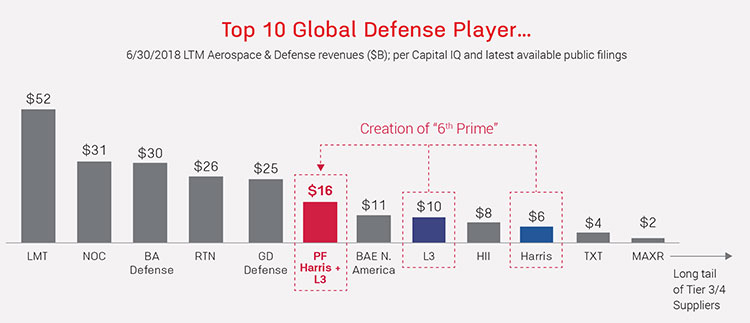
Harris Corporation and L3 Technologies Inc. have agreed to combine in an all-stock merger of equals to create a global defense technology leader focused on developing differentiated and mission-critical solutions for customers around the world.
The combined company, L3 Harris Technologies, will be the sixth largest defense company in the U.S. and a top 10 defense company globally, with approximately 48,000 employees and customers in more than 100 countries.
For 2018, the combined company is expected to generate net revenue of approximately $16 billion.
Image: from Fact Sheet by Harris and L3 Technologies
According to the press release, increased scale will enable the combined company to be more cost competitive, expand capabilities to provide end-to-end solutions across multiple domains of air, sea, land, space and cyber, enhance leadership in RF and spectrum technologies and establish a leading platform-agnostic supplier and integrator.
L3 Harris Technologies will be headquartered in Melbourne, Florida, and led by a team that reflects the strengths and capabilities of both companies and will share equally in the integration process, the companies said.
With a combined workforce of 22,500 engineers and scientists, the combined company plans to accelerate investment in select technologies to expand leadership in key strategic domains including national security.
Image: from Fact Sheet by Harris and L3 Technologies
Company Backgrounds
Harris Corporation is a solves customers’ mission-critical challenges by providing solutions that connect, inform and protect. Harris supports government and commercial customers in more than 100 countries and has approximately $6 billion in annual revenue. The company is organized into three business segments: Communication Systems, Electronic Systems and Space and Intelligence Systems.
L3 Technologies is a provider of global ISR, communications and electronic systems for military, homeland security and commercial aviation customers. With headquarters in New York City and approximately 31,000 employees worldwide, L3 Technologies develops advanced defense technologies and commercial solutions in pilot training, aviation security, night vision and EO/IR, weapons, maritime systems and space. The company reported 2017 sales of $9.6 billion.
CEO Statements and Leadership
“This transaction extends our position as a premier global defense technology company that unlocks additional growth opportunities and generates value for our customers, employees and shareholders,” said Harris chairman, president and CEO William M. Brown. “Combining our complementary franchises and extensive technology portfolios will enable us to accelerate innovation to better serve our customers, deliver significant operating synergies and produce strong free cash flow, which we will deploy to drive shareholder value. Integration planning is already underway, and from our extensive experience with integration, we are confident in our ability to realize $500 million of annual gross cost synergies and $3 billion of free cash flow by year 3.”
L3 Chairman, President and Chief Executive Officer, Christopher E. Kubasik said, “This merger creates greater benefits and growth opportunities than either company could have achieved alone. The companies were on similar growth trajectories and this combination accelerates the journey to becoming a more agile, integrated and innovative non-traditional 6th Prime focused on investing in important, next-generation technologies. L3 Harris Technologies will possess a wealth of technologies and a talented and engaged workforce. By unleashing this potential, we will strengthen our core franchises, expand into new and adjacent markets and enhance our global presence.”
The combined company’s board of directors will have 12 members, consisting of six directors from each company. William M. Brown will serve as chairman and chief executive officer, and Christopher E. Kubasik will serve as vice chairman, president and chief operating officer for the first two years following the closing of the transaction. For the third year, Brown will transition to executive chairman and Kubasik to chief executive officer, after which Kubasik will become chairman and chief executive officer.
Additional senior leadership positions for L3 Harris Technologies will be determined at a later date.
Shareholder Information
Under the terms of the merger agreement, which was unanimously approved by the boards of directors of both companies, L3 shareholders will receive a fixed exchange ratio of 1.30 shares of Harris common stock for each share of L3 common stock, consistent with the 60-trading day average exchange ratio of the two companies.
Upon completion of the merger, Harris shareholders will own approximately 54 percent and L3 shareholders will own approximately 46 percent of the combined company on a fully diluted basis.
The merger is expected to close in mid-calendar year 2019, subject to satisfaction of customary closing conditions, including receipt of regulatory approvals and approval by the shareholders of each company.
Digital technology has provided society with hundreds of advances that make life easier and better for everyone. From the personal computer to the internet to the smartphone to the Internet of Things, we are increasingly living in a technologically driven world.
But what if those technologies were bound together and used to build a smart city?
What would it take to make such a complex network feasible? And what would it look like to live in a such a city?
Are these just the fevered imaginings of science fiction writers or could it be a real possibility? Let’s dig a little deeper.
Image: jamesteohart/Shutterstock.com
What is a smart city?
First, let’s put aside our Jetsons-inspired ideas of smart cities and look at what they really are.
A smart city contains a framework of Information and Communication Technologies (ICT), specifically designed to answer the overwhelming growth of urban centers.
The ICT framework contains an intelligent network of machines and objects that transmit data wirelessly. These cloud-based applications receive, evaluate and manage data, in real time, to help cities, corporations, and citizens make better decisions that improve quality of life.
Citizens can engage with smart city systems using smartphones and other mobile devices, including cars and homes.
Think the Internet of Things except on a much, much bigger scale. A citywide scale.
Being able to connect to a city’s physical infrastructure and services has the potential to cut costs and improve the city’s sustainability. Cities can improve energy dispersal, streamline city services, decrease traffic and reduce air pollution.
The development of smart cities starts with a digital foundation that allows better functionality, that’s more responsive to citizens, and ultimately creates a better urban environment.
Smart city technology
Cities are quickly on the move to embrace smart city technology. Autonomous vehicles are already providing data that could create environments where traffic lights become obsolete. Cities can reduce the number of cars as different transportation modes work together and communicate in real time.
Wi-Fi hotspots on a larger scale can transform the way users access information. And, as increased use of public transportation reduces the number of cars on the road, parking needs will decrease and enable cities to repurpose land for housing.
Energy sources could be better integrated into cities, helping to make a cleaner environment for everyone. At the same time, embedded sensors to detect gunshots or explosions will alert emergency services workers much faster. These systems will also find water, electric and gas issues and assign workers to make repairs as soon as they are needed.
All of this possible technological growth is predicated on the idea that technologies can help make people’s lives better in urban areas.
The six keys to a smart city
There are six key technologies that make a smart city efficient:
Smart energy. Residential and commercial buildings in smart cities use less energy, and the energy used is analyzed and data collected. Smart grids collect data and redirect energy to where it is most needed.
Smart transportation. Traffic monitoring is already happening in many large cities. But, by making parking smarter, people spend less time looking for parking spots. Smart traffic lights have cameras that monitor traffic so that it’s reflected in the traffic signals.
Smart data. The enormous amounts of data collected in a smart city must be analyzed in real time to be useful. Open data portals are one option for smart cities.
Smart infrastructure. Because smart cities can analyze huge amounts of data, leaders will be able to plan better. This allows proactive maintenance and better planning for future demand.
Smart mobility. The technology and the data that travel through it must be able to seamlessly move in and out of different municipal and private systems. Without this mobility, a smart city won’t work.
Smart internet of things (IoT) devices. Sensors are an essential part of a smart city. The information collected from sensors can be used to dispatch repairmen for immediate maintenance or emergency services for a car accident.
These technologies work in tandem to make a smart city smarter. As the world’s population continues to grow, and people relocate to urban areas, the need for smarter cities will help make the best use of all resources.
The powerful features of smart cities
Emerging trends like automation, machine learning and the internet of things (IoT) are keys leading to smart city adoption. It’s possible that any area of city management can be developed in a smart city.
Smart parking meters, for example, use an app to help drivers find empty spaces without circling crowded city blocks. The smart meter has a digital payment feature to prevent the need for coins.
Smart traffic management can monitor and analyze traffic flows to maximize streetlight usage and stop roadways from being too congested during rush-hour traffic. Smart public transit in smart cities ensures that public transportation meets user demand. Smart transit companies can coordinate services in real time to improve efficiency.
Energy efficiency and conservation are also features of smart cities. The smart sensors in the ground dim smart streetlights when there is no auto or pedestrian traffic. Smart grid technology can improve operations, maintenance and planning, supply power as needed, and monitor power outages.
Sanitation can also improve with smart technology, with either internet-connected trash cans and IoT-enabled fleet management for collection, or sensors that measure water parameters and guarantee the quality of drinking water.
Creating sustainable smart cities
Sustainability is another perk of smart cities. The population in urban centers is expected to increase in the coming years. Recent studies show that 80 percent of the U.S. population lives in urban areas, while that number was just 60 percent fifty years ago. Smart technology can help cities sustain growth and create efficient systems for citizens.
In Chicago, a smart cities innovation accelerator known as UI Labs has started developing tech to monitor storm drainage systems to stave off flooding from the Chicago River. A nine-month pilot program using the new tech was just completed and the researchers are compiling the data.
Another project being developed in Chicago creates digital maps of underground utility systems. Previously, the city had to rely on outdated and unfinished maps, slowing construction permitting and emergency services. Videos taken during underground construction are being turned into a digital map of the city underground.
In Spain, Barcelona has achieved a great deal in developing smart city tech and is reaping the benefits. The city has reduced congestion, lowered emissions, saved money on water and power, and improved economic development. Barcelona’s commitment to creating smarter urban infrastructure will change the quality of life for all who work, live, and visit the city.
The improvements have already saved the city a significant amount of money and lowered the consumption of water and energy. Barcelona estimates savings of $58 million on water, $50 million in increased parking revenues, and the creation of 47,000 new jobs. The city has also saved an additional $37 million each year in reduced lighting costs.
The Barcelona Lighting Masterplan, published in 2012, uses smart technologies to enhance efficiency and use of city lampposts. Two years later, more than 1,100 lampposts had been transformed to LED, which reduces energy waste. The lampposts can sense when pedestrians are nearby; the lights automatically dim to further conserve energy when the streets are empty.
To maximize the efficiency of city parks, Barcelona has implemented technologies that remotely sense and control park irrigation. The sensors also monitor rain and humidity, so maintenance workers can decide how much irrigation is necessary in each area. A system of electronic valves is remotely activated to deliver needed water around the city. The program has helped the city achieve a 25 percent increase in water conservation, saving nearly $555,000 per year.
As urban centers grow, the population places creates more environmental pressures. Smart City applications could help cut emissions by up to 15 percent.
In many cities of the developing world, the most water is lost from leakage in pipes. Deploying sensors and using the data can cut such losses by up to 25 percent. Overall, cities could potentially save 25 to 80 liters of water per person per day.
Air-quality sensors can identify the sources of pollution and galvanize governments and corporations into action. Beijing closely tracked the sources of air pollution and the city reduced deadly airborne pollutants by roughly 20 percent in less than a year.
While the data suggest that there are certainly obtainable benefits to smart city technologies, it is prohibitively expensive to build the infrastructure needed to implement the technologies. This has lead to Smart Cities Challenges in many countries.
Smart City Challenges
Smart city challenges are about achieving outcomes that all communities can find measurable improvements in, and ways to tackle previously unsolvable problems. New partnerships and networks can be formed to engage with residents and forge new relationships that encourage smart city innovation.
The Smart Cities Challenge in Canada is a competition open to empower communities around the globe to address local issues through new partnerships, using a smart cities approach. Finalists will receive support to develop their proposals. Winning proposals will receive prize money to help implement their new technologies.
In the United States, the Smart City Challenge was launched in 2015 by the U.S. Department of Transportation (DOT).
The winning proposal by Columbus, Ohio, is receiving prize money to help implement new technologies. According to the DOT, Columbus put forward an impressive, holistic vision for how technology can help all residents move better and access opportunity.
As challenge winners and their partner innovators improve a cityscape with smart technology, the benefits will be reaped by all who call the community home. Benefits can and will include lowered crime rates, increased job availability, independence for seniors and the disabled, a healthier environment, empowered citizens, and more opportunities for people to become active and have access to improved health care.
Conclusion
It seems that smart cities are fast approaching. As society’s technologies become intertwined and upgraded, the options for deploying new systems is unlimited.
And while there are certainly drawbacks in creating and maintaining a smart city, it is clear that humankind is looking forward to the next step in societal evolution.
This article originally appeared on IQ Directory and is reprinted with permission.
Anna Kucirkova
Anna Kucirkova speaks three languages has a passion for kids and writing. While she has been to many places in Europe and Southeast Asia, she still wants to explore the rest of the world.
Tallysman, a manufacturer of high-performance GNSS antennas and related components, has introduced a high-accuracy choke ring antenna: the Tallysman VeraChoke.
Adapting existing innovations on its patented VeraPhase antenna, Tallysman’s VeraChoke offers a choice in form factor for reference and monitoring applications.
The VC6100, the first model variant of the VeraChoke antenna, shares a common high-efficiency element design with itsVeraPhase counterpart. With the choke-style form-factor, however, the rings have been optimized for all GNSS signals and are slightly pyramidal in shape to improve reception of low-elevation satellites.
The VC6100 choke ring antenna offers a tight phase center variation of no more than ±1 mm for every frequency. It is capable of receiving all GNSS signals and achieves a very low axial ratio, the company said.
According to Tallysman, the VC6100 is competitively priced to help increase antenna density for reference deployments, CORS networks and monitoring applications. The antenna also supports large and small SCIGN radomes.
Tallysman’s GNSS antennas are on display at Booth Number 12.0D.059 at Intergeo, taking place Oct. 16-18 in Frankfurt, Germany.
Open-source JavaScript library for creating immersive connections to infrastructure digital twins.
Bentley Systems has released its iModel.js library, an open-source initiative designed to improve the accessibility, for both visualization and analytical visibility, of infrastructure digital twins.
iModel.js can be used by developers and IT professionals to quickly and easily create immersive applications that connect their infrastructure digital twins with the rest of their digital world, the company said.
iModel.js is the cornerstone of Bentley’s new iTwin Services that combine iModelHub, reality modeling and web-enabling software technologies within a Connected Data Environment for infrastructure engineering.
iModelHub manages an iModel as a distributed database with an intrinsic ledger of changes — enabling alignment, accountability and accessibility of its digital components — to form the backbone of an infrastructure digital twin.
The iModel.js library is a comprehensive collection of JavaScript packages that build on the most open, popular and flexible standards for modern cloud and web development. It is written in TypeScript and leverages open technologies including SQLite, Node.js, NPM, WebGL, Electron, Docker, Kubernetes, and HTML5 and CSS. The same codebase can produce cloud services and web, mobile and desktop applications. The source code is hosted on GitHub and is distributed under the MIT license.
With iModel.js, it is simple to create a web-based experience that shows interactive “nD” views (1D, 2D, 3D, 4D, etc.) of iModels that are assembled and synchronized from BIM files and other digital engineering models, as well as from data created directly with iModel.js.
Those same views can also include digital (reality) context, real-time sensor data, and other data from enterprise sources and analytics. Since the iModel is synchronized by iModelHub, it always reflects the most recent updates from all project participants, who are thus able to visualize and analyze changes between points in time or between versions. Importantly, only users and applications authorized by the iModel owner, through iModelHub, are granted access through iModel.js.
“iModel.js gives Hatch the ability to implement a stakeholder engagement technology that extends the iModelHub visionary technology,” said Johan Palm, program manager of digital project delivery at Hatch. “We can expose complex project information to a level that is accessible, consumable and extendable via the cloud and in context to the 3D model. Most importantly we can do so in a manner that embraces change as the project progresses. iModel.js aligns with Hatch’s internal development strategies as it is built on modern, highly portable web technology. Bentley is a key software technology partner on Hatch projects globally where our main objective is to provide a positive impact to our client’s assets and operations.”
“The digital twin powered by iModelHub is efficiently improving project management, substantially reducing the waste of resources caused by site problems and will achieve digital handover after completion of the project for visual operations and maintenance,” said Cai Chengguo, chair and general manager at Shenzhen Expressway Consulting Group.
“We firmly believe that iModel.js, and of course the foundation upon which it is built, is the most open, productive, intuitive and powerful development environment for capital projects and infrastructure assets, ever,” said Keith Bentley, Bentley Systems’ founder and CTO. “We’re excited to work with user organizations, strategic partners and third-party developers to build an open ecosystem around iModels to tap the vast potential of infrastructure digital twins. With iModel.js, the well-refined techniques of mainstream cloud and web development can leverage the physical and virtual reality in digital twins with near-zero impedance. By open-sourcing the libraries we use to create our iTwin cloud services, we expect to foster a substantial and vibrant ecosystem of innovation.”
BAE Systems’ XTS Guard 5, equipped with the company’s Geospatial eXploitation Products (GXP), has successfully demonstrated its ability to provide U.S. intelligence organizations with access to geospatial imagery and data from BAE Systems’ GXP Platform, ensuring secure sharing between networks of various security classifications and sections.
The innovative software demonstrated secure information sharing between government agencies and networks at the Enterprise Challenge, referred to as the EC-18, held this past spring.
“Our expertise in developing technologies that quickly exploit massive amounts of data has allowed us to a product that brings numerous advantages to U.S. military intelligence organizations to securely transfer data from multiple sources,” said Kevin Malone, vice president of analytics systems at BAE Systems. “The EC-18 demo proved XTS Guard 5’s readiness to deliver operational success for a number of agencies.”
EC-18 is an annual exercise sponsored by the Office of the Under Secretary of Defense, which allows Department of Defense agencies and international partners to demonstrate information sharing across disparate networks prior to their solution’s deployment. A guard is a cybersecurity appliance solution that resides between classified and unclassified domains for agencies using intelligence libraries.
As an intelligence organization accesses geospatial imagery and data from BAE Systems’ GXP Platform, XTS Guard 5 provides cross-domain search functionality. This breaks down information stovepipes and secure boundaries that currently exist, providing a bridge between security domains to allow intelligence analysts to quickly and easily gather information that was previously cumbersome and time consuming to obtain. It saves analysts’ time, reduces operating costs, and allows decision makers to act more quickly, the company said.
The product is further enhanced by SMARTXD from Sterling Computers, which is a key enabling component to secure multi-domain information sharing within an agency or large organization. It allows existing customer applications to become multi-domain enabled and share releasable data across security domains, including coalition partners. This capability has been successfully demonstrated in the last three Enterprise Challenge events.
The XTS Guard 5 demo at EC-18 showed that the product’s architecture will support multi-enclave and multi-compartment controlled information sharing, for information that is subdivided based on its sensitivity, with advanced administration and auditing, ensuring that releasable information stored on a section of an internal network is sharable. It proved the effective transfer of multiple data types in near-real time, including email, attachments and chat.
Offering industry-leading geospatial intelligence and movement intelligence solutions, including licensed software and professional services, BAE Systems’ GXP 5 delivers advanced data management, image exploitation, tracking analytics, geospatial production and intelligence reporting, the company said.
Spectra Precision has launched a new brand identity and name for its survey and geographic information systems (GIS) suite of solutions. The organization will now be known as Spectra Geospatial.
The announcement was made at Intergeo 2018, the conference on geodesy, geoinformatics and land management, taking place Oct. 16-18 in Frankfurt, Germany.
The new Spectra Geospatial brand builds upon the reputation and equity built under the previous Spectra Precision identity and now reflects the organization’s evolution of providing a broad range of solutions specifically focused on the geospatial industry, the company said.
“We’ve built a strong reputation for quality and innovation over the past 25 years,” said Olivier Casabianca, general manager of Spectra Geospatial. “We are very proud to bring a new name and brand to the market that accurately reflects our customer and dedication to the industry.”
Spectra Geospatial delivers products to the survey, GIS and construction markets, with the brand offering a complete product portfolio including GNSS, GIS, optical total stations, data collection hardware, and field and office software.
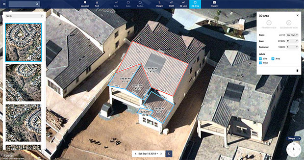
Nearmap high-resolution aerial image showcasing new toolset in MapBrowser, captured Sept. 15, 2018. (Image: Nearmap)
Nearmap has introduced a complete measurement toolset in MapBrowser for the solar, roofing and other rooftop industries.
The new tools allow users to measure roof-pitch, height, width and area, enabling roofers and solar installers to confidently measure rooftops and structures from high-resolution oblique aerial images, the company said.
The new MapBrowser helps customers significantly reduce onsite visits during the quoting and planning stages of projects and complements their remote roof/site inspection workflows, giving many small businesses the power of expensive systems that only large companies use.
“Gone are the days of climbing on roofs to take measurements,” said Tony Agresta, executive vice president of product at Nearmap. “Delivered to the cloud within days of capture, our aerial imagery allows roofers, solar companies and other small businesses to carry out assessments from the comfort of their office. Once the domain of large companies, the new features provide businesses of all shapes and sizes with the tools they need to save time, plan and estimate more accurately at a fraction of the price.”
Using Nearmap’s new tools, roofers and solar companies will be able to:
Prospect more efficiently by viewing and expanding opportunities through aerial maps instead of other, more traditional ways.
Process leads more quickly by qualifying prospects prior to visiting a potential job.
Reduce costs associated with the qualification and proposal stages.
Create better proposals using up-to-date, high-resolution photos, giving companies a better chance at winning a client’s business.
Close more sales with the most accurate and competitive quotes.
Increase revenue without adding systems or headcount.
Businesses in construction, home building, painting, insurance and other industries can also benefit from these new tools to accurately measure areas on properties in three dimensions. Nearmap’s aerial imagery can help users to show context for work being done, and the imagery can be annotated with notes, drawings and measurements that provide details of the plan.
Nearmap Oblique imagery can be accessed through a standard web browser using Nearmap’s intuitive MapBrowser application. In addition, Nearmap Oblique photos are published at sub-7.5cm ground sampling distance (GSD) — better than satellite imagery — which allows users to see great detail, Nearmap said.
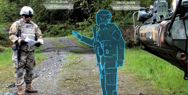
The U.S. Army considers virtual reality training as an important path ahead to prepare warfighters.
The U.S. Army awarded Bohemia Interactive Simulations (BISim) a major extension to demonstrate technologies for a cloud-enabled, virtual world training capability.
BISim is a global developer of advanced military training and simulation software.
The contract award helps meet the requirements of the Army’s Synthetic Training Environment (STE) initiative. STE aims to converge virtual, constructive and gaming training environments into a single unified architecture.
The ambitious STE project will enable simulation systems Army-wide to leverage a persistent virtual world for any imaginable training need, including support for multi-domain operations incorporating cyber and space.
Central to STE is a cloud-enabled One World Terrain (OWT) that will let warfighters conduct virtual training and complex simulations anywhere on a virtual representation of the Earth. OWT will leverage cloud technologies to deliver to the point of need, ensuring a common and high-fidelity whole-Earth terrain representation for a multitude of different simulation systems.
The Synthetic Training Environment will assess Soldiers in enhancing decision-making skills through an immersive environment. (Photo: U.S. Army)
“The U.S. Army’s vision for STE marks a monumental change in how they acquire, develop and deliver new simulation and virtual training technologies to soldiers,” said Pete Morrison, BISim’s co-CEO and chief product officer. “We’re honored to be selected to assist the Army in developing innovative solutions that will shape the future of how virtual training is used to enhance operational readiness.”
BISim has been developing its next generation of simulation technologies since 2014. The new technology suite includes a cutting-edge, military-specific whole-earth game engine, deterministic AI, an efficient geospatial terrain server and component-based development technology.
BISim technology underpins funded research and development for One World Terrain. Additionally, BISim recently demonstrated Reconfigurable Virtual Collective Trainer (RCVT) prototypes for STE. The latest OTA extension is a significant ramp up in the breadth and ambition of the technology being demonstrated.
BISim’s STE offering includes four core technologies uniquely suited to meeting future military simulation requirements (including U.S. Army requirements).
VBS Blue. A high-performance, whole-planet data ingestion and rendering engine with a very high level of procedural detail, designed to ingest any conceivable terrain data format as well as source data directly. VBS Blue will support networked (cloud) terrain paging and geo-specific insets as well as the latest graphics technologies. It provides photorealistic detail, and includes a massive vegetation library representing every region on Earth. The technology is highly applicable across all types of image generation and is optimized for many AR/VR applications.
STEWS. A geospatial data server that provides efficient networked access to the various data sources required for rendering applications. STEWS provides a curated database of terrain data layers that can be streamed into any STE-connected client application at run time (including non-BISim applications). Any application connected to STEWS can stream high fidelity terrain data in a performant manner. Both new and legacy terrain formats are supported through new STEWS plug-ins.
VBS Control. High fidelity, doctrinal and deterministic entity-level artificial intelligence that is uniquely suited to operation on whole-earth terrain. VBS Control runtime offers highly efficient real-time path planning that allows AI to move seamlessly through open, urban and interior spaces. The VBS Control Editor allows powerful new AI behaviors to be developed at both the individual entity level and at higher levels of command for land, sea and air assets.
Gears. A software development framework that defines a standard way for components to communicate through formal interfaces. Gears uses a component-based architecture to promote rapid development by building applications from self-contained systems and having them communicate via formally defined interfaces. This allows functionality to be reused and avoids the complexity of tightly coupled systems. See www.gears.studio for more information.
The Army also selected BISim for a five-year contract to support their Games for Training Program and BISim’s technology is being rolled out on CCTT (the U.S. Army’s largest ground simulator training program).