Ottonomy.io partners with Posten Norge for first-mile supply chain automation with autonomous robots
One of Europe’s largest postal services, Posten Norge, is testing the future of logistics delivery with Ottobots in Oslo.
Ottobot maker Ottonomy.io is collaborating with Posten Norge AS and Holo on trials for automating first-mile delivery in an effort to pave the way for autonomous delivery. See the project page.
The Posten Group is a post and logistics group that develops and provides post, communications and logistics services in Norway and the Nordic region. Holo is an implementer, integrator and operator of autonomous vehicles in the region.
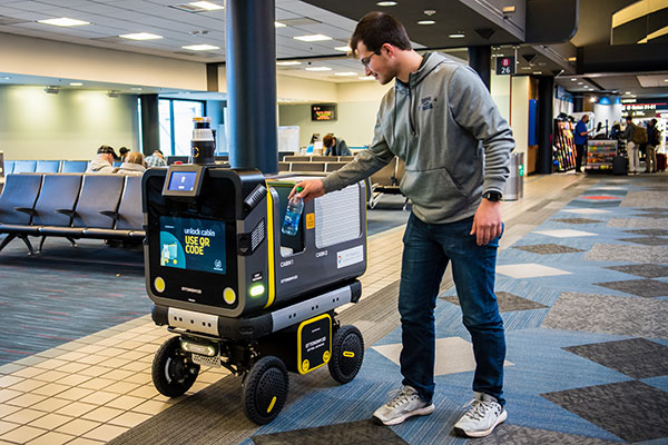
An Ottobot delivers product orders to airport travelers. (Photo: Ottonomy)
The partnership with one of Europe’s largest logistics companies is oriented towards testing how autonomous robots can improve intra-logistics, especially in city centers. Posten Norge will be leveraging Ottobots for first-mile pick-ups, receiving and delivering goods for AMOI, a Nordic digital marketplace, from the busy Aker Brygge metropolitan area in Oslo.
“Autonomous robots have previously been tested by other companies with the focus entirely on final delivery to the customer,” said Sven Richard Tønnessen from Posten’s Department of Emerging Technology. “We want to evaluate how robots can become part of Posten’s future logistics solutions.
“This project, which utilizes both humans and robots, offers many new opportunities for increasing efficiency and productivity for our organization,” Tønnessen said. “We will continue to utilize our existing pool of human couriers for delivering goods to the customers, while the robot takes care of the intra-logistics part of the supply chain.”
Conquering the First Mile
The first mile has been a pain point for organizations in metropolitan areas. First-mile delivery involves moving products from the manufacturer’s or retailer’s warehouse to a central holding center. From this location, a carrier, shipping company or logistics partner picks up the products and takes it to the next leg in the destination.
“The logistics with delivery vans at Aker Brygge is extremely demanding in terms of parking and time consuming,” said Kenneth Tjønndal Pettersen, Posten Norge. “Together with our partners, we want to test the various applications for autonomous technology, which can enable simpler logistics and reduced noise in the cityscape.”
A recipient of the 2021 Sustainability Product of the Year award by Business Intelligent Awards, Ottobot will be used to determine how Posten Norge AS can increase sustainability and efficiency for the logistics supply chain in the future.
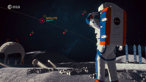
The European Space Agency (ESA) has released a new video describing the Moonlight Initiative, part of NASA’s Artemis program.
ESA is a key partner in Artemis, which aims to return people to the Moon by the end of decade. Dozens of other international public and private missions are setting their sights on the lunar surface in the coming years.
However, to achieve a permanent and sustainable presence on the Moon, reliable and autonomous lunar communications and navigation services are required. ESA is working with industrial partners on the Moonlight Initiative, to become the first off-planet commercial telecoms and satellite navigation provider.
After launch, three or four satellites will be carried into lunar orbit by a space tug, and deployed one by one to form a constellation of lunar satellites. The number and specification of these satellites are being defined.
The constellation’s orbits are optimized to give coverage to the lunar south pole, where sustained sunlight and polar ice make it the focus of upcoming missions.
Moonlight will provide data capacities sufficient to serve these planned and future missions, with a navigation service that enables accurate real-time positioning for all lunar missions.
OriginGPS is exhibiting a new GNSS module based on a MediaTek chipset at Electronica in Munich this week.
The company is also demonstrating how the OriginIoT system — equipped with a high-stability GNSS module from the company’s miniature range — can be speedily deployed to replace traditional control systems, providing a new way to remote-control devices that move.
Also on show is a weather board equipped with a range of sensors for multiple particulate matter, with data presented on a gauge-rich dashboard updated automatically.
ORG600-MK01, OriginGPS’ new sub-1m precision dual-frequency module, is built with MediaTek’s chipset. (Image: OriginGPS)
“We are excited to be launching our latest GNSS dual-frequency module, the ORG4600-MK01, at the Electronica trade fair this month,” said Haim Goldberger, OriginGPS’ Founder and CEO. “At GITEX 2022 in Dubai, we heard from visitors how demands for more precision and lower costs were on the rise. Thanks to the tenacity of our engineering team, the solution has sub-1m precision and is competitively priced. In fact, the cost of our new module — built with MediaTek’s dual-frequency chipset — is lower than that of our first L1+L5 module, the ORG4600-B01, which is based on Broadcom’s chipset and provides high stability with up to 10cms accuracy.”
The new 10 mm x 10 mm dual-frequency GNSS product is based on 12 nm technology and was designed for applications deployed in challenging environmental conditions. The solution also includes RTCM, a logger and accurate orbit prediction.
OriginGPS is showcasing its miniature GNSS modules and cellular IoT systems and devices in Booth B5-242 at Electronica, Munich, Nov. 15-18.
The companies will combine their experience to guarantee robust and reliable navigation thanks to the Galileo constellation
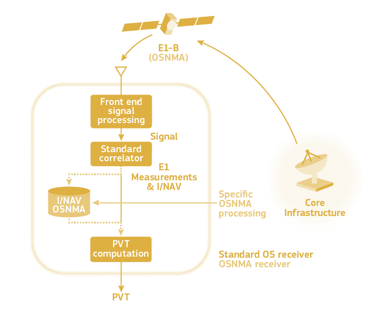
The OSNMA scheme. (Image: ESA)
UAV Navigation is participating in the OSNMAplus project consortium led by Qascom, an Italian enterprise in the domain of GNSS authentication.
The OSNMAplus project aims to develop services and technologies that make use of novel services provided by Galileo, particularly use of OSNMA and I/NAV improvements.
The OSNMA service is a data authentication function for Galileo Open Service users worldwide, freely accessible to all. OSNMA provides receivers with the assurance that the received Galileo navigation message is coming from the system itself and has not been modified. The I/NAV improvements are part of a recently released update of the Galileo Interface Control Document, aiming at optimizing the navigation performance of Galileo even further.
“With the OSNMAplus project, we’re providing technological solutions that will facilitate the adoption of OSNMA in new and existing navigation systems,” said Carlo Sarto, OSNMAplus project manager. “We’re also providing cloud-based services and multiplatform SDK that can be used in consumer devices to improve the OSNMA experience and increase the robustness of the navigation solution.”
The OSNMAplus technologies will be subject to an extensive test campaign. The OSNMA-based navigation will be tested in a flying drone to assess effective resilience against potential malicious GNSS interference.
At its meeting Nov. 2-11 in London, the IMO Maritime Safety Committee adopted a resolution to approve the BeiDou Message Service System (BDMSS) for use in the Global Maritime Distress and Safety System (GMDSS).
The GMDSS is an internationally recognized distress and radio communication safety system for certain-sized ships under the IMO Safety of Life at Sea Convention (SOLAS). The automated ship-to-shore and ship-to-ship system uses navigation satellites and terrestrial radio systems with digital selective calling technology.
The meeting summary states:
Following the assessment and evaluation of an application by China Transport Telecommunication Information Group Co. Ltd. (CTTIC) to recognize the BeiDou Message Service System (BDMSS) for use in the GMDSS, the MSC adopted an MSC resolution on Statement of recognition of the maritime mobile satellite services provided by CTTIC through BDMSS.
BDMSS was evaluated taking into account the existing requirements of the criteria for the provision of mobile satellite communication systems in the GMDSS (resolution A.1001(25)).
The recognition is currently limited to a coverage area within 75°E to 135°E longitude and 10°N to 55°N latitude.
BeiDou is the third system approved for GMDSS, following Inmarsat and Iridium, both of which use GPS and Galileo to provide tracking services.
The BLK2FLY, recognized for its productivity and innovation, is a fully integrated autonomous flying laser scanner. It’s part of Hexagon’s BLK suite of autonomous reality capture sensors designed for speed, portability, ease-of-use and mobility.
To compile the list, TIME solicited nominations from TIME’s editors and correspondents around the world, and through an online application process, paying special attention to growing fields — such as the electric vehicle industry, green energy and the metaverse. TIME then evaluated each contender on key factors including originality, efficacy, ambition and impact.
“Having our reality capture technology recognized by TIME as one of the year’s best inventions is both humbling and inspiring. It validates our mission to build Smart Digital Realities that empower an autonomous, sustainable future,” said Hexagon President and CEO Ola Rollén. “Our technologies aim to change the world for the better, turning concepts that were once thought impossible into real solutions that benefit everyone. By optimizing quality, productivity, efficiency and safety — profitably — we can help industry achieve sustainability through mitigated risk, less waste and reduced cost.”
As a lidar-based unmanned aerial vehicle (UAV), the BLK2FLY addresses costly and complex issues, quickly and accurately capturing everything from large outdoor spaces to complex structures and environments.
For example, when renovating building structures, it can easily capture the exterior dimensions of previously inaccessible or difficult-to-reach areas such as rooftops and facades. The resulting colorized 3D point clouds are instrumental in building information modeling (BIM) processes, documenting site conditions and improving an asset’s operation, from infrastructure to utilities to industrial facilities.
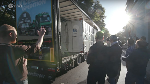
ESTEC Test Centre, Europe’s largest satellite testing facility, said goodbye on Nov. 14 to the final satellite in the Galileo First Generation series, as it departed to OHB in Germany. There, it will rest in storage until ready to be sent for launch.
In a new European Space Agency (ESA) video, the people responsible for readying the satellites for space have gathered to reflect on the end of an era.
The work on Galileo began two decades ago with two test Galileo In-Orbit Validation (GIOVE) satellites, followed by a series of operational launches. The two GIOVE satellites and all 34 Galileo Full Operational Capability satellites were tested at ESTEC.
Next will come the Galileo Second Generation satellites, already in development.
Europe’s 2nd Horizon Europe call has been launched for European GNSS, Galileo and Earth observation projects, offering total funding of €48.1 million.
The Horizon program is managed by the European Union Agency for the Space Programme (EUSPA). It funds research and innovation by small and mid-size enterprises, academia, public actors and others that will stimulate development of space applications and solutions using EUSPA data and services.
The 2nd call aims to to strengthen downstream capabilities and modernize the EU public sector by offering cutting-edge solutions based on Galileo, Copernicus, EGNOS and GOVSATCOM.
Funding is being offered for projects that make use of Galileo and EGNOS in smart mobility applications. Other projects fuse Copernicus data with artificial intelligence to boost the European economy and help modernize the public sector. For the first time, the call seeks to deliver satellite communication use cases based on the forthcoming GOVSATCOM system.
Below is a breakdown of the funds’ distribution per thematic area.
Visit the EU’s funding & tender opportunities portal for detailed information about the EUSPA call and the topics available. The deadline for applications is March 2, 2023.
Septentrio’s mosaic-T is built specifically for resilient and precise time and frequency synchronization under challenging conditions. (Photo: Septentrio)
Fugro has signed a tri-party cooperation agreement with GNSS receiver company Septentrio and synchronization equipment manufacturer Meinberg to launch the Fugro AtomiChron real-time synchronization and authentication service.
Numerous sectors rely on resilient and highly accurate time synchronization, including telecommunications, finance and energy. The timing technology eliminates time drift caused by clocks counting time at slightly different rates, and provides extreme stability that surpasses current precision frequency standards.
With up to sub-nanosecond accuracy, Fugro AtomiChron includes Navigation Message Authentication (NMA), ensuring reception of genuine GNSS signals and time synchronization improvements. Integrated anti-spoofing detection further prevents interference with GNSS timing signals providing accuracy, authentication, validity and security for end users.
The agreement ensures that the Fugro AtomiChron service will be available in new Septentrio mosaic-T GNSS receivers, as well as a selection of Meinberg GNSS clocks, without the need for additional physical interfaces or separate antennas.
“Septentrio is a forerunner in the area of robust and resilient GNSS solutions,” said Jan Van Hees, business development director at Septentrio. “With the addition of the unique Fugro AtomiChron service, we are pleased to further strengthen our offering and provide our customers even more accurate and reliable solutions for resilient GNSS timing.”
What is the most promising approach to increasing the location accuracy of smartphones?
Ismael Colomina
“In addition to the use of increasingly available augmentation services, such as Galileo’s free High-Accuracy Service (HAS), I see two development directions that may help, particularly in the context of positioning in urban areas where smartphones are most used. One is the use of 3D city models — in general, 3D geoinformation — to compensate for multipath, non-line-of-sight and occlusion effects. The other is to use signals that are robust against those effects, which today are only available in geodetic-grade receivers.” — Ismael Colomina, GeoNumerics
For the navigation of autonomous vehicles, will GNSS become essential, or will it be relegated to a secondary role by robotic navigation methods?
John Fischer
“The PNT solution cannot be from a single source because autonomous navigation requires high integrity. Therefore, it’s not that GNSS will be relegated to secondary status, it’s that no one method will be primary. An intelligent fusion of diverse sensors —including GNSS — will provide the PNT solution along with an integrity metric that safeguards operation. The various sensors must agree. If they don’t, no trust can be put into the solution and autonomous navigation will cease. The definition of a new integrity metric that quantifies this trust level is needed.” — John Fischer, Orolia
Ellen Hall
“Because GNSS provides high precision and widely available PNT, it will continue to be a critical component in navigation while working with computer vision, inertial measurement units (IMUs) and lidar through sensor fusion. As a secondary component, GNSS serves a vital role for localization and validation.” — Ellen Hall, Spirent Federal Systems
“Seen & Heard” is a monthly feature of GPS World magazine, traveling the world to capture interesting and unusual news stories involving the GNSS/PNT industry.
Screenshot: Lying in State Queue tracker
Queue Tracker for the Queen
After the passing of Queen Elizabeth II on Sept. 8, the British government launched a live queue tracker app to give people an idea how long they would have to wait to pay their respects at her lying in state at the Palace of Westminster. The app also used What3Words to help locate the end of the line using a three-word tag. The queue grew dramatically in the days before the funeral as tens of thousands lined up, some waiting as long as 16 hours. The app also showed locations of public toilets, drinking water and first-aid stations along the queue route.
Lake Sarez. (Photo: Astronaut Photography Collection/NASA)
A Dam Problem Solved
Lake Sarez, deep in the Pamir mountains of Tajikistan, was created only a century ago when a strong earthquake triggered a massive landslide. The area experiences considerable seismic activity, which could result in massive flooding downstream should a landslide dam break. With the help of 40 donkeys, 10 scientists and 30 staff from the National Time Service Center of the Chinese Academy of Sciences transported and installed a BeiDou-based deformation monitoring system at the dam. The team had to resolve technical problems in the rugged area, such as providing sufficient solar power and communications. With the system now operating, the dam is being monitored in real time down to the millimeter.
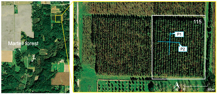
Figure 3. (Image: CC BY 4.0, Remote Sensing 14, no. 17: 4274)
Counting the Forest for the Trees
Integration of aerial and ground-based mobile mapping sensors and systems is enabling a team of Purdue digital forestry researchers to locate, count and measure more than a thousand trees in a matter of hours. “The quick, accurate inventory of the global forest ecosystem will improve our ability to prevent forest fires, detect disease, perform accurate carbon counting and make informed forest management decisions,” said Songlin Fei, the Dean’s Remote Sensing Chair. The Purdue-made systems integrate GNSS and inertial navigation devices with lidar and cameras, deployed with manned aircraft, drones and backpack-mounted systems. The technology gathers a variety of information about each tree, including height, trunk diameter and branching formation. The team maintains the precise location and time tags of all acquired features.
Photo: Skeiron
Saving Ukranian Heritage
By the end of May, at least 367 incidences of destruction had occurred to Ukraine’s museums, churches, theaters and libraries. Through the project #SaveUkranianHeritage, mapping company Skeiron is capturing sites in high detail using laser scanning and photogrammetry. For a UNESCO-protected church in Lviv, the team gathered more than 300 individual laser scans and 6,000 photos to create a 3D model. The company has two laser scanners — a Leica C10 and Leica ScanStation P20, DLSR cameras and a drone. To support the project with funding or equipment, visit skeiron.com.ua/en/saveukrainianheritage/.
RNT Foundation President Dana A. Goward was in London last week for a PNT Leadership Seminar. Here is his report.
In March 2021 the United Kingdom’s government told parliament that a national positioning, navigation, and timing (PNT) strategy was to be published imminently.
Yet, in addition to the normal duties of running the world’s sixth largest economy, the last 20 months have been busy for the UK government: evolving issues with Brexit, more COVID, three prime ministers, Russia’s invasion of Ukraine, financial crises… Small wonder that publishing a strategy to address a “not-right-now” concern hasn’t come to the top of the pile.
Royal Institute of Navigation Leadership Seminar
Yet PNT resilience is an incredibly important issue requiring long-term solutions. As a “learned society,” the Royal Institute of Navigation (RIN) has a duty to bring together professional expertise and educate the public on such important topics.
On Nov. 1, the RIN convened a UK PNT Leadership Seminar with “the UK’s leaders in government, industry, academia and key user communities.” Its goals were to not only highlight the economic benefits of resilient PNT leadership for the UK, but also to “develop a view of approaches, priorities and next steps.”
Attendees expressed a wide variety of concerns. These ranged from difficulties growing and retaining talent in the field, to a lack of understanding among the public and government about the essentiality of PNT to virtually every aspect of modern life.
There was general agreement that establishing a coherent and resilient PNT program in Britain would have dual benefits.
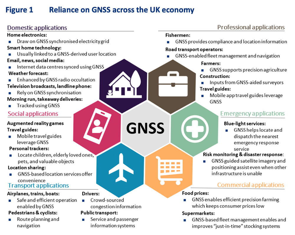
First, it would help protect the nation’s economy and national security. Malicious and natural threats to space-based PNT mean that complementary systems are needed to mitigate outages. A government sponsored study in 2017 estimated losses exceeding £5B during a five-day outage. The study’s authors conceded at the event that longer outages would realize much larger per day losses as infrastructure and systems increasingly suffered.
Action to mitigate disruption of space-based PNT was especially important for the UK, according to the concept paper, because “the sectors where the UK has the most value at risk from a loss of GNSS-provided PNT are precisely the sectors that lack adequate resilient backup options.”
Image: London Economics report
Economic Benefits of Resilience
Secondly, British PNT resilience would also have great positive benefit to the economy, especially if the UK established itself as a leader in the field. A concept paper prepared for the seminar by London Economics found that the value chain for the UK would include research and development, provision of PNT infrastructure, PNT module manufacturing, system integration,and application development.
Among the UK stakeholders most likely to benefit, according to the paper, were companies and institutions that were part of the value chain, along with user communities, government and the public overall.
Attendees and the London Economics concept paper agreed that consistent and focused government leadership was essential. Government must create the conditions and confidence to stimulate the whole ecosystem to deliver resilience and the associated economic benefits. In fact, the paper envisioned the government as an “anchor customer” for resilient PNT providers and device manufacturers. This idea echoed that expressed by representatives of PNT providers in the United States earlier this year. The need for government to protect itself with resilient PNT (thus becoming an anchor customer) was a primary theme during a PNT roundtable held by the U.S. Department of Transportation in August.
Getting Government’s Attention
Finding a way to communicate the importance of PNT and UK government leadership in a way that would generate action was another theme from seminar attendees. One panel member despaired the problem was “Little Susie hasn’t died yet.” It is hard to get government’s attention without a disaster of some sort. Another attendee suggested creating a video to increase public awareness thereby causing government to take notice and act.
Finding a high-profile champion was also discussed. An attendee told a story about a member of the royal family’s interest in quantum technologies, how that led to meetings with government, and establishment of the UK’s £1B quantum tech program. While several indicated this isn’t really a path RIN could use, a combination of personal connections or celebrity with the ability to “tell the story” can be very helpful.
Parliament also Concerned
Just three days after the RIN event, the UK government’s leadership of resilient PNT efforts was also formally criticized by Parliament.
It described PNT services as “key enablers of Critical National Infrastructure (CNI) sectors that underpin our national security and defence interests as well as a wide range of other economic activities…”
After reviewing testimony received by the committee the report made several important findings.
Regarding GPS and Galileo:
“The reliance on foreign systems is concerning due to the potential for the UK to be blocked from using them in the future. Reliance on space-based systems is also not advisable as these can be disrupted through jamming attacks or adverse space weather. The loss of PNT services would be detrimental to the UK, with power distribution, financial transactions, and transport systems all seriously affected, and the UK’s national security put at severe risk.”
Commenting on the UK government’s efforts with OneWeb:
“We are concerned that the Government seems to be progressing towards plans to use OneWeb’s low Earth orbit (LEO) satellite constellation to provide PNT services in the future, despite suggestions from experts that there are many technical issues…”
And the Science and Technology Committee is not alone in Parliament being concerned with the nation’s lack of progress on PNT. In its October 2022 report “Defence Space: through adversity to the stars” the House of Commons Defence Committee said:
“Given the vital need for a resilient PNT network both for defence and for other aspects of critical national infrastructure we are deeply concerned by the complacent attitude towards PNT within government, and by the seemingly low priority which the MOD [Ministry of Defense] attaches to this work. Government must publish the conclusions of the SBPP and should set out a clear timetable for producing and taking forward the UK’s PNT strategy in its response to this report.”
‘Move PNT in Government above the Department Level’
Expressing the utmost frustration, last week’s report from the Science and Technology Committee recommended reassigning responsibility for PNT to a higher level of government than where it is positioned now.
The Department for Business, Energy and Industrial Strategy (BEIS) is the ministry currently responsible for publishing and implementing the long-delayed PNT Strategy.
The committee said that this long delay is evidence the ministry is “…refusing to commit to the critical action that needs to be taken.”
It also said:
“…we believe the responsibility for PNT should lie outside of any one department. The Government should establish the National Security Adviser (NSA) as having overall responsibility for the UK’s access to secure PNT capabilities. The NSA should ensure that the importance of developing secure PNT systems is understood throughout Government and take responsibility for developing a programme and budget for the work that needs to be carried out.”
UK Cross-Government PNT Office
For now, there is no evidence the UK government will adopt Parliament’s recommendation to move responsibility for PNT to the National Security Adviser.
However, BEIS has created a cross-government PNT effort to address the nation’s needs. Attendees at the RIN seminar reported that the team is staffed with representatives from several departments, including the MOD.
Seminar attendees said that PNT is getting to be MOD’s highest space-based priority. While not in a position to lead, Defence was strongly supporting cross-government efforts.