The satellite company spoke to 20,000 people in 11 countries across the globe to uncover their perceptions of space, what happens “up there” and how they think it impacts life here on Earth.
The survey found that most people have no idea about the benefits of space. Only one third are excited about space, with 47% concerned about space junk and just 8% associating space with communications and connectivity.
Just 8% of respondents associate space with communications and connectivity.
“From connecting rural communities to helping solve climate change, we know the enormous potential space holds to improve life on Earth, and what it has already brought us,” Inmarsat said in a statement. “Now, both the magnificent possibilities and the potential risks of space, which Inmarsat is working hard to address, need to be showcased to the world.”
The report also features contributions from renowned figures in the sector including Scott Kelly, former astronaut and commander of the International Space Station, and Josef Aschbacher, director general of the European Space Agency.
“The research findings mark a real wake-up call for the space industry,” Inmarsat said. “It’s clear that people have a low understanding of the breadth and richness of the work being done in space today. Perhaps because the technology deployed is essentially invisible, people do not appear to understand the role space is already playing in their everyday lives, nor its potential to deliver a brighter future for our planet.”
ComNav Technology now provides a GNSS high-precision positioning solution for navigation and positioning of autonomous lawn mowers. Environmentally friendly and intelligent robotic lawn mowers are growing more popular, making the mowing task easier, safer and more convenient.
R&D background
It is difficult to develop autonomous lawn mowers because they obtain navigation information by means of visual and acoustic sensors, usually through embedded cables in the working area and detection through eddy current sensors. The shortcomings are obvious: before the mower starts, it must be set up with cables and other equipment. Cable requirements differ in various countries, and cable laying can be complicated, wasting resources and money.
With these difficulties in mind, ComNav applied its K8 series of GNSS high-precision modules to lawn mowers to break through the application limit. It solved this accuracy problem to make the lawn mower achieve centimeter-level driving according to the setup path in an open field. With ComNav’s other technologies — quantum algorithm and LAI, HighLock, PPP, RTK-KEEP — the law mowers continues to operate under trees, around corners or in other obscured areas.
Introduction of ComNav’s solution
With the K8 series module, ComNav facilitates the lawn mower’s fieldwork with position data provided by GPS, GLONASS, Galileo, Beidou, QZSS, IRNSS and SBAS.
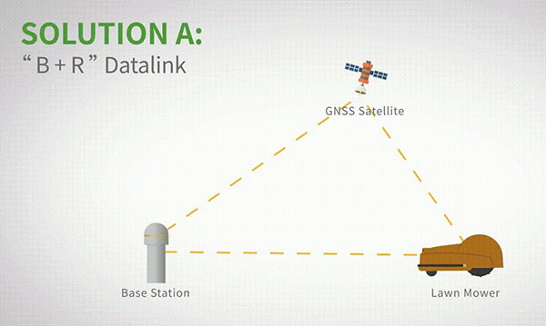
The high-precision positioning system for lawn mowers consists of a base station and a rover station. Three solutions are recommended for the terminal to obtain differential data from the base station.
Base and rover datalink. A base station acquires differential data through a datalink and provides corrections to the rover. The rover station — comprising the parts installed on the lawn mower, including the GNSS antenna, the GNSS high-precision module, datalink and UHF antenna — enables centimeter-level positioning and navigation.
Image: ComNav
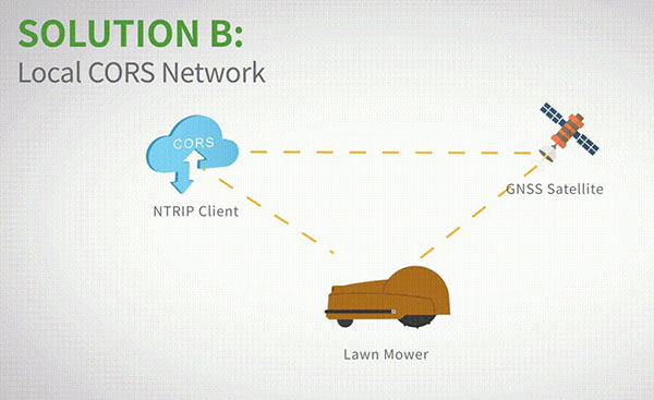
Local CORS network. Utilizing existed local CORS, the rover station obtains differential data from the CORS service, enabling the lawn mower to achieve positioning and navigation accuracy on a centimeter level.
Image: ComNav
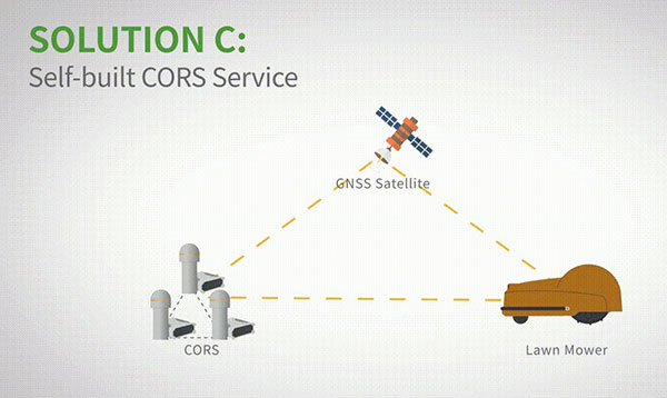
Self-built CORS network. Base stations can be placed anywhere based on requirements. Doing so eliminates the worry about prevailing conditions and makes high-precision positioning and navigation of lawn mowers possible.
Image: ComNav
Technology Features
LAI technology. ComNav’s patented low-power anti-interference (LAI) technology provides a jamming-to-signal ratio of up to 50 dB. Power consumption is only 0.1 W when turned on. By quickly detecting and eliminating interference with simple settings, LAI technology can reduce failure time and ensure safe operation. The technology can generate a spectrum diagram of interference sources, enabling identification of interference types and potential interference sources.
Quantum algorithm. ComNav’s quantum algorithm has sophisticated technology for detecting and repairing cycle slips. It uses full-constellation and full-frequency tracking capabilities along with multi-frequency combination, model and parameter estimation. Quantum is able to eliminate errors caused by the ionosphere, the troposphere and multipath in seconds. As a result, the initialization time of real-time kinematic (RTK) is greatly shortened and precision and reliability are improved. Meanwhile, the extra-long baseline calculation capability expands the operation range.
RTK-KEEP technology. By estimating model and parameter values, RTK-KEEP Technology can reduce errors caused by satellite orbit, clock difference, ionosphere and troposphere when the base station’s data is lost. Centimeter-level accuracy can be kept for more than 10 minutes, greatly improving the availability of RTK.
Benefits of ComNav’s Solution
ComNav’s solution allows the lawn mower to achieve centimeter-level positioning and reduce mowing repetitions. It helps the lawnmower to operate safely and reliably in the corners, under trees, or in other places where satellite signals are weak or lost. With its strong anti-interference capabilities, the lawn mower can maintain continuous and effective positioning in complex environments, meeting the needs of a variety of applications.
In 2020, OCP-TAP started working on highly precise and hyper-scalable time synchronization services in its data center market, using a GNSS clock source and precision time protocol (PTP) technologies. OCP-TAP technology adds scalability and improves the accuracy of timekeeping within the infrastructure industry.
In 2021, OCP-TAP integrated its technology into the time card and introduced it as an open-source solution to build time servers.
The Protempis Res720 embedded module provides a highly accurate GNSS clock source to further increase the accuracy, resiliency and adoption of the OCP-TAP’s new time card duo, which was announced in an OCP Tech Talk on June 2.
OCP-TAP provides a new collaborative community focused on designing hardware and software to efficiently support critical timing accuracy and resiliency demands on computer network infrastructure.
Protempis Res720
Protempis’s Res720 embedded module adds a dual-band GNSS time reference to the time card to improve resilience, noise rejection and anti-spoofing and anti-jamming capabilities.
The Res720 GNSS embedded timing module is suitable for data centers, 5G Open RAN and XHaul, smart grids, industrial automation and SATCOM networks. It provides 5 ns timing accuracy, dual-band GNSS support and anti-jamming/anti-spoofing capabilities.
The Res720 embedded module provides unparalleled performance as a timing source in embedded systems, including to time servers, network interface cards, radio units and routing/switching devices for 5G, private wireless, Open RAN and data networks.
“Protempis brings its expertise in GNSS and network synchronization to Meta, the OCP-TAP, and the open-sourced time card. Their highly accurate dual-band GNSS product has shown how it can improve operations,” said Ahmad Byagowi. Byagowi is inventor of the Time Card, founder and project lead for OCP-TAP, and a research scientist at Meta.
“We are honored that our Res720 dual-band technology will be used for enabling time-sensitive applications over OCP-compliant and PTP-aware networks,” said Karen Guldan, Protempis president. “We look forward to a continuing partnership with OCP-TAP and global network leaders working to advance solutions to provide ongoing timing accuracy and resilience.”
Precisional, an affiliate of The Jordan Company (“TJC”), announced May 9 that it completed the previously announced transaction to acquire four industrial technology businesses from Trimble, including Protempis (formerly Trimble Time and Frequency).
“Seen & Heard” is a monthly feature of GPS World magazine, traveling the world to capture interesting and unusual news stories involving the GNSS/PNT industry.
Xona’s first demonstration mission successfully completed testing at Experior Laboratories and prepares for launch on a Falcon 9 in May. (Photo: Xona)
TAKING GNSS PRIVATE
At press time, Xona Space Systems’ first in-space demonstrator satellite, named Huginn, was ready to launch on May 25 aboard Space X’s Transporter 5 mission. Xona said the launch is a significant step toward realizing its high-performance commercial navigation system, a constellation of small, powerful satellites in low Earth orbit that will meet the navigation and timing needs of intelligent systems.
U.S. cellular carrier AT&T is rolling out location-based routing to automatically transmit wireless 9-1-1 calls to the appropriate call centers, rather than relying on which cell tower handles the call. Cell towers can cover a 10-mile radius, and overlap with more than one call-center boundary. With location-based routing, a device can be located and routed within 50 meters of the device location. The “Locate Before Route” feature from Intrado enables AT&T to use device GNSS and hybrid information to route the call to the right call center.
Russian jets have been found using GPS receivers, while ground vehicles use paper maps, according to the UK Express. The GPS receivers were found taped to the dashboards of Russian SU-34s downed in Ukraine because of “the poor quality of their own systems,” UK Defense Secretary Ben Wallace said in a speech. With many reports of maintenance and aging issues for the Russian military, most likely the jets did not have quality GNSS receivers rather than the fault lying with GLONASS.
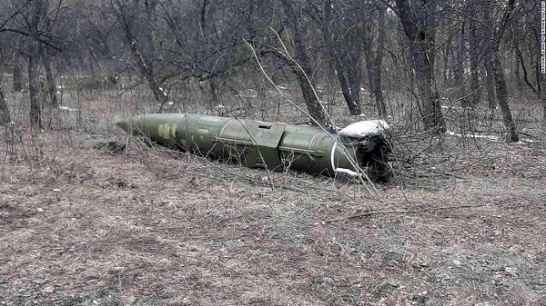
A Russian short-range ballistic missile, believed to be an unexploded Iskander missile, was found near Kramatorsk, Ukraine, in this photo released March 9 by Ukrainian authorities. (Photo: National Guard of Ukraine handout via Reuters)
UNEXPLODED BOMBS MAPPED
The HALO Trust is partnering with Esri to map unexploded ordnance in an immediate humanitarian response to the war in Ukraine. More than 10 million Ukrainians have been displaced by the war and many are forced to move across a landscape littered with unexploded rockets, bombs and landmines. In response, Esri has committed its cutting-edge geographic information system (GIS) software resources, expertise and staffing in support of HALO’s mission in Ukraine. HALO already is using GIS to map the heaviest conflict zones, and the partnership with HALO will support planning for future clearance operations.
Skydel 22.5 features advanced hardware-in-the-loop testing
Orolia has released Skydel 22.5, a significant software upgrade to its Skydel simulation product line that features advanced hardware-in-the-loop (HIL) testing solutions providing very low to zero effective latency.
The enhanced visualization tools can monitor internal latency through real-time curves showing when the data is generated and sent to the RF signal. Users can also review the transmission of HIL packets for optimizing the entire network’s latency, checking its stability (jitter), and that data is available and used at the right time in Skydel.
HIL testing is an essential step in the verification process of the model-based design (MBD) approach because it involves all the hardware and software that will be used operationally. HIL verification can test a standalone device-under-test (DUT) or, more generally, an entire complex system consisting of multiple DUTs in both open- and closed-loop architectures.
“The vast majority of problems encountered by engineers on HIL systems are related to poor control of the latency of the entire simulation chain, as they are insufficiently accessible, transparent and controlled on the competing systems,” said Pierre-Marie Le Veel, principal system architect and product manager for GNSS simulation. “Thanks to these tools, our high-end performance and well-known intuitive automation, Skydel dramatically reduces the implementation time of a HIL system (which can be very significant) and, therefore, the project’s overall cost.”
Photo: Orolia
In addition to these tools, Skydel implements modern extrapolation algorithms that achieve zero effective latency. These algorithms make it possible to keep position errors negligible, even for equipment with very high dynamics used in national defense applications such as missiles, rockets and guided shells.
“These advanced HIL algorithms and tools are available – and with the same performance – on our Wavefront simulation systems to test controlled reception pattern antenna (CRPA) systems,” Le Veel added.
Additional constellations, signal types and options such as real-time kinematic (RTK) and multi-instance are available along with dedicated bundled simulation starter packages for automotive.
The upgrade is available at no additional cost for existing users operating Skydel 22.5. Application notes, support documents and tutorials are available online.
Flyability has unveiled the Elios 3, a collision-tolerant drone equipped with a lidar sensor for indoor 3D mapping. The drone is powered by a new SLAM engine called FlyAware that lets it create 3D models as it flies.
It also is accompanied by a new version of Flyability’s software for inspectors, Inspector 4.0.
The launch of the Elios 3 marks a new partnership with GeoSLAM. The Elios 3 comes with an Ouster OS0-32 lidar sensor, allowing inspectors to collect data for the creation of survey-grade 3D models using software from GeoSLAM.
The drone gives users real-time digital replicas of previously inaccessible areas with the inclusion of the lidar sensor and GeoSLAM’s Connect software. The drone is protected by a cage and has advanced collision-tolerance features that allow inspectors to fly it inside dangerous confined spaces such as boilers, pressure vessels and mines.
With its integration with Connect, the Elios 3 creates survey-grade point clouds. Fitted to the back of the drone, the lidar sensor maps the environment in real time using Flyability’s FlyAware SLAM algorithm.
Survey package option
Those that need highly accurate data can upgrade to the survey package, provided by GeoSLAM, providing access to the Connect software, as well as specialist Volumes and Draw modules. Powered by GeoSLAM’s established SLAM algorithm, Connect offers a simple and automated way to process point cloud data.
Using the survey package, data is processed to an accuracy of 8 mm, suitable for mapping hazardous environments such as mines and industrial applications including chimneys, production plants, warehouses, silos and tanks. Processed data can then be viewed in the easy-to-use 3D viewer and exported to industry-standard file types including LAZ, LAS, PLY and TXT for use in third-party software.
The Boston Dynamics Spot robot equipped with Velodyne lidar. (Photo: Velodyne)
Velodyne Lidar Inc. has signed a multi-year agreement for its lidar sensors with Boston Dynamics, a mobile robotics company best known for its “Spot” dog-like robot.
Boston Dynamics selected Velodyne’s sensors to provide perception and navigation capabilities for its highly mobile robots. The sensors enable mobile robots to operate autonomously and safely, without human intervention. They provide real-time 3D perception data for localization, mapping, object classification and object tracking.
Velodyne’s power-efficient sensors support autonomous mobile robots in a wide range of challenging indoor and outdoor environmental conditions, including varying temperature, lighting and precipitation, the company said.
Velodyne’s lidar sensors will enable the robots to autonomously navigate complex environments, safely avoiding obstacles and finding the fastest route to perform tasks in environments from manufacturing plants and construction sites to distribution centers and warehouses.
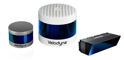
The Alpha Puck, Alpha Prime and Velarray M1600 lidar sensors. (Photo: Velodyne)
Manuscripts submissions are being sought for a special issue of Applied Sciences, which will be dedicated to “Recent Advances in GNSS High-Precision Positioning and Applications.”
Deadline for manuscript submissions is Dec. 30. Full instructions are available on the special issue website.
The goal of the special issue is to highlight recent developments in high-precision GNSS positioning models, algorithms and applications. The topics of interest include, but are not limited to, the following:
multi-GNSS multi-frequency PPP, RTK, PPP-RTK models and algorithms, making use of high-grade and low-cost equipment
quality characterization of smartphone GNSS observations
functional and stochastic models for multi-GNSS precise positioning with smartphones
characterization and handling of multi-GNSS inter-system and inter-/intra-frequency code and phase biases
ionospheric and tropospheric modeling
carrier-phase ambiguity resolution
GNSS-LEO observation modeling and integration
integrity monitoring
GNSS-based lunar navigation
satellite orbit dynamics.
Special-issue editors are Safoora Zaminpardaz and Dimitrios Psychas.
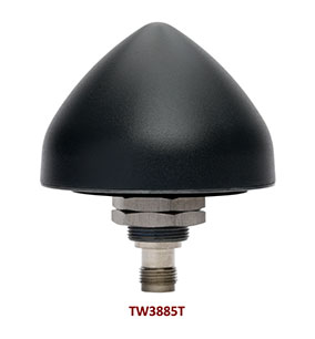
Tallysman Wireless has added the housed TW3885T dual-band (L1/L5) Accutenna technology timing antenna to its line of GNSS products.
The dual-band TW3885T antenna supports
GPS/QZSS L1/L5
Galileo E1/ E5a/b
BeiDou B1/B2/B2a
GLONASS G1/G3
Satellite-based augmentation systems (SBAS) in the region of operation: WAAS (North America), EGNOS (Europe), MSAS (Japan) or GAGAN (India).
Historically, dual-band antennas and receivers commonly supported GPS L1 and L2 and GLONASS G1 and G2. In recent years, GPS, GLONASS, Galileo, BeiDou and NavIC have added GNSS signals in the L5 frequency band (1164-1217 MHz). As a result, the new dual-band GNSS standard has become L1 and L5. Tallysman’s new TW3885T antenna has been tuned to provide optimal support for both the upper (L1/ G1/E1/B1/) and lower (L5/G3/E5/B2) GNSS bands.
The TW3885T is housed in a through-hole mount, weatherproof (IP69K) enclosure. For permanent installations, L-bracket (PN 23-0040-0) or pipe (23-0065-0) mounts are available. Tallysman provides an antenna installation guide that recommends a 100-125 mm ground plane and provides antenna installation and cable connector waterproofing best practices.
The radio frequency spectrum has become congested worldwide as many new LTE bands have been activated, and their signals or harmonic frequencies can affect GNSS antennas and receivers. In North America, the planned Ligado service, which will broadcast in the frequency range of 1526 to 1536 MHz, can affect GNSS signals. New LTE signals in Europe (band 32, 1452–1496 MHz) and Japan (bands 11 and 21, 1476–1511 MHz) have also affected GNSS signals. Tallyman’s new TW3885T mitigates the effects of these new signals.
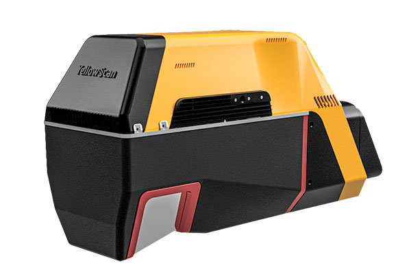
YellowScan has released a new long-range lidar scanner. Voyager is a powerful solution for both manned and unmanned aircraft.
With Voyager’s wide field of view, all of the points collected are oriented toward the ground, meaning there is no loss of points. This also means 1.5 million points per second will be usable, which would not be the case with a 360° scanner.
Voyager combines a Riegl VUX-120 laser scanner with a Trimble Applanix AP+ 50 AIR or Applanix AP+ 30 AIR GNSS-inertial board, providing precision of 0.5 cm and accuracy of 1 cm.
Voyager’s detection and processing of up to 15 target echoes per laser pulse allows for excellent vegetation penetration. Its has an extremely fast data-acquisition rate of up to 1800 kHz, suitable for projects requiring the highest point density.
The laser scanner’s specifications can be customized to fit the needs of various projects and platforms, and can be combined with YellowScan’s full suite of software solutions to easily extract, process, merge and colorize point-cloud data.
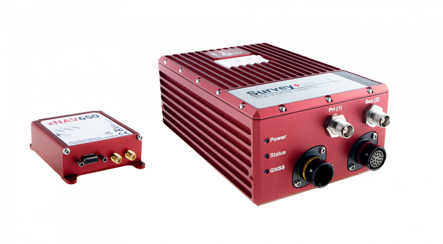
OxTS manufactures inertial navigation systems (INS) and proprietary software on which survey professionals have come to rely. Our devices, the Survey+ and the xNAV650, output highly accurate position, heading and pitch/roll measurements. An advanced navigation engine combines streams of data from onboard inertial measurement units (IMUs) and GNSS receivers. This data can then be used in a multitude of applications including lidar survey, mobile mapping and open road positioning.
Surveying, especially with a lidar sensor, can be a complicated art. There are many factors to consider even before you begin. However, system manufacturers involved in the survey industry, such as OxTS, are taking steps to simplify lidar survey.
The end goal for many lidar surveyors is to create an accurate point cloud. However, to produce the best possible results, the hardware and software involved must be working together in unison.
Hardware = lidar sensor and INS
Software = georeferencing, post-process and configuration
In this article, we have picked out a few of our favorite developments on the topic of simplifying lidar survey.
Research and Development
OxTS invests substantially in research and development to ensure that our hardware and software developments meet the ever-evolving demands of the survey industry. Many of the improvements generally center around improving accuracy, clarity of results and user experience. However, general industry demands also drive some development.
For example, the increasing use of drones in surveying has increased demand for smaller and lighter INS hardware. Whilst developing smaller and lighter hardware is therefore important it cannot be to the detriment of reliability and accuracy. The xNAV650 was born from this industry demand.
Although development of the xNAV650 was primarily driven by the needs of the survey industry (smaller/lighter hardware), other improvements OxTS has made to the software portfolio has focused on improving user experience.
xNAV650 and Survey+ inertial navigation systems. (Photo: OxTS)
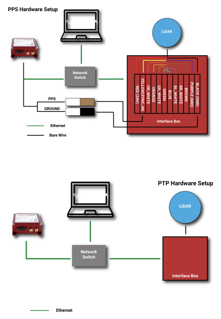
Precision Time Protocol (PTP)
One of the major advances in OxTS INS technology over the past 12 months is PTP. The drive to include PTP capability on all OxTS Survey INS devices was the intention to help surveyors simplify the lidar survey set-up process.
When using compatible lidar sensors, such as those from Hesai and Ouster with an OxTS INS, surveyors no longer need to build complex wiring solutions. A simple ethernet ‘plug-and-play’ process is all that is required.
The images below show a traditional PPS wiring set-up vs PTP:
A traditional PPS wiring set-up vs PTP. (Image: OxTS)
Software
To get the desired outcome, an accurate georeferenced point cloud, from any lidar survey in a timely manner the software must be simple and straightforward to use. As the saying goes “complexity is the enemy of execution,” and this is what drives software development at OxTS.
Once the lidar and INS are plugged in and ready to survey, configuration should be straightforward. A simple configuration wizard, such as the one available in NAVsuite (OxTS’ complimentary software toolbox) should structure the set-up process so that nothing is missed.
NAVconfig – OxTS’ INS configuration software. (Image: OxTS)
The latest NAVsuite update (version 3.3) included a new PTP graphical user interface (GUI) to simplify survey set-up even further.
Other tools are included within NAVsuite that allow users to analyze, troubleshoot and post-process their INS data. Read the NAVsuite for Survey and Mapping infosheet to find out more about these.
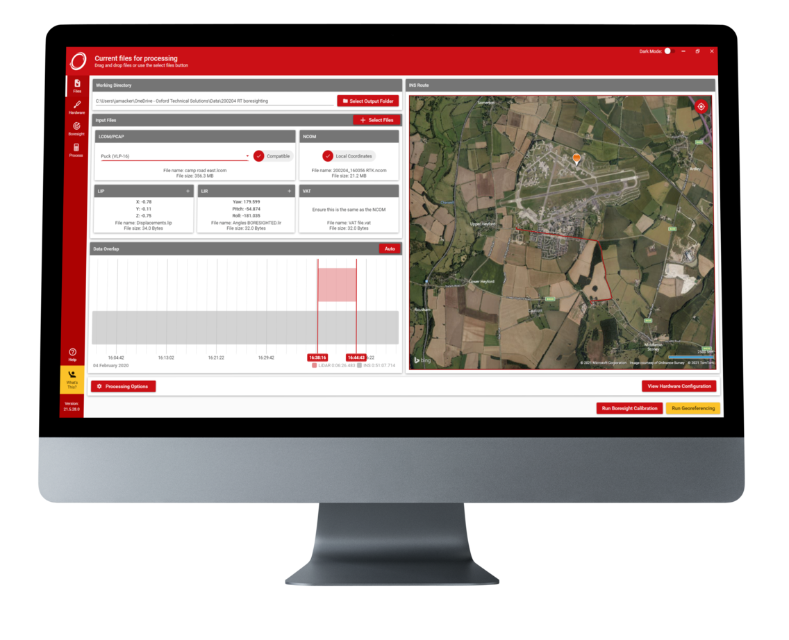
OxTS Georeferencer
OxTS Georeferencer. (Image: OxTS)
Since its launch approximately two years ago, OxTS Georeferencer has gone through some major changes. The first version included compatibility with the Velodyne VLP-16 lidar sensor. This meant that users of the VLP-16 had a quick and simple way to georeference the lidar data.
Over the course of the next 24 months, multiple new sensors have been introduced. Sensors from Hesai, Ouster, Livox and new Velodyne devices are now available, giving users more choice than ever before when it comes to choosing the hardware to do their job. Visit the OxTS Georeferencer product page for a complete list of available sensors.
Furthermore, as well as the integration of new sensors, we have introduced a raft of new features to improve the user experience for professional lidar surveyors. These include:
a 3D hardware setup viewer to enable quick and intuitive survey configuration
multiple processing options that allow users to view and process only the areas of the point cloud that are of interest therefore minimizing the data size
the ability for users to process data in a range of coordinate systems including, local coordinates, ECEF, LLA (latitude, longitude and altitude)
processing advances that enable users to process data faster than ever before.
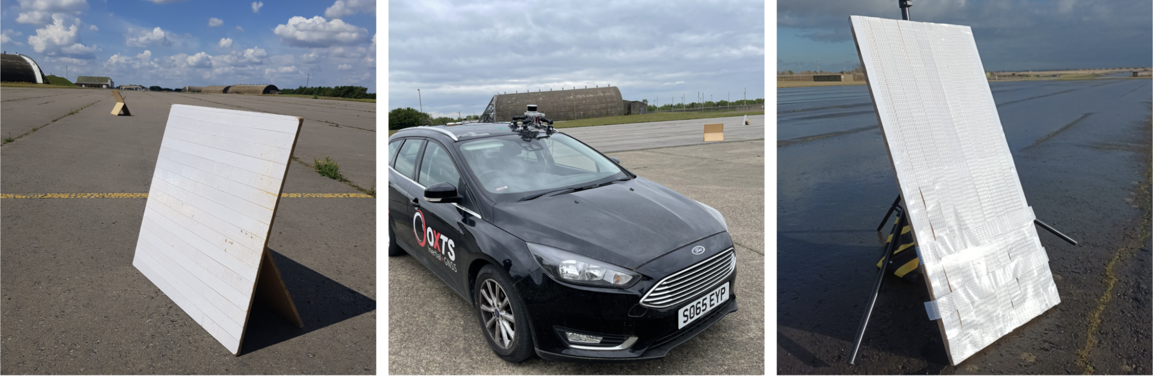
Data-Driven Boresight Calibration
One of the most challenging parts of the lidar survey set-up process is aligning the coordinate frames of the lidar and INS devices. Failure to align these with sufficient accuracy can lead to blurring and double-vision in point clouds.
Many surveyors try to do this by eye, or by developing expensive CAD models, however there is a simpler, quicker and more cost-effective way – using data.
Built into OxTS’ lidar georeferencing software OxTS Georeferencer, there is an optional boresight calibration tool. It requires the surveyor to survey two static “targets” (see the images below) from multiple distances and angles. The data is then calibrated, and the angle displacement calculated to a tenth of a degree.
OxTS Georeferencer includes an optional boresight calibration tool. (Photos: OxTS)
Once the initial boresight calibration has taken place, if the setup is not altered in any way, the coordinate frame alignment will be valid for any future survey.
The Future
In the coming weeks and months, the development of new hardware and software features will further streamline the survey process.
Ola Rollén to be proposed as chairman of the board
Paolo Guglielmini, Hexagon
Hexagon AB has announced that Paolo Guglielmini will succeed Ola Rollén as president and CEO of Hexagon AB, effective Dec. 31.
Gun Nilsson has decided to step down as CEO for Hexagon’s principal shareholder MSAB on Oct. 1 and leave her position as chairman of Hexagon AB at the Annual General Meeting (AGM) 2023. MSAB, in consultation with Hexagon’s nomination committee, will propose Ola Rollén as new chairman of the board at the AGM 2023.
Guglielmini, currently Hexagon’s chief operating officer (COO) and president of Hexagon’s Manufacturing Intelligence (MI) division, has served in key roles since joining Hexagon in 2010, from strategy and business development to M&A and general management. He has been instrumental in expanding MI’s focus towards software-centric quality data solutions, and with his team driving the business towards all-time-high performance in 2021. Before joining Hexagon, Guglielmini held positions at CERN, the European Organization for Nuclear Research in Switzerland and Accenture. He holds a master of science in engineering and master of business administration from IMD.
”I’m happy that we have found an internal solution for my succession, which will bring long-term stability and continuity, but at the same time needed rejuvenation as we prepare this amazing company for the next big leap strategically,” Rollén said. “I have preoccupied myself with the well-being of Hexagon 24/7 for the last 22 years, and it’s a true privilege to be able to continue to follow the company’s successful development as chairman.”
“I’m honored by the opportunity to build upon the legacy that Ola and our team have created over the past two decades, and excited to lead Hexagon into the future,” Guglielmini said. “We are very well positioned to capitalize on the vast opportunities ahead, combining software, sensors and autonomous technologies to create sustainable value for our stakeholders.”
At the same time, the following organizational changes will be made:
Josh (Joshua) Weiss, currently COO of Hexagon Geosystems, will succeed Guglielmini as president for Hexagon Manufacturing Intelligence, effective July 1. Weiss has served in multiple leadership roles since joining Hexagon in 2015, from his most recent role to the president of Geosystems’ mining and heavy construction businesses. Weiss will report to Hexagon’s president and CEO and be a part of the Executive Management Team.
Michael Ritter, currently president of Hexagon Autonomy & Positioning, will assume a new senior role overseeing Hexagon’s Autonomy & Positioning, Mining and Agriculture divisions, effective immediately. In this role, Ritter will be responsible for leading the strategy of the businesses, to accelerate synergies and strengthening the solutions portfolio for Hexagon’s customers. Ritter will continue reporting to Hexagon’s president and CEO and be a part of the executive management team.
Maria Luthström, currently head of Sustainability and Investor Relations for Hexagon, will succeed Ritter as president of Hexagon Autonomy & Positioning, effective Oct. 1. Luthström joined Hexagon in 2015 and has been instrumental in expanding the company’s strategy and environmental, social and governance agenda, strengthening Hexagon’s culture and increasing shareholder value. Luthström will report to Michael Ritter.